Showing 2333 items in the category Documentation with item type Map
-
 Bendigo Historical Society Inc.
Map - BAGSHOT : COUNTY OF BENDIGO, November 1948
Map. Bagshot. County of Bendigo, Huntly, Whirrakee, Egerton, Goornong, Ellesmere, Wellsford. Reedy Creek, Sandy Creek. Drawn and reproduced at the Department of Lands and Survey, Melbourne, Victoria. November 1948, Price 2/-. By authority J.J. Gourley, Government Printer, Melbourne. (number 46 in map cupboard 1)J.J. Gourley, Government Printer, Melbourne.map, bendigo, bagshot -
 Whitehorse Historical Society Inc.
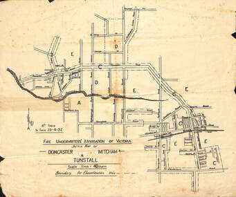
Map - Fire Underwriter's Association Sketch Map, Fire Underwriter's Association of Victoria, Doncaster, Mitcham and Tunstall, 29/4/1932
Shetch map of Doncaster, Mitcham and Tunstall. Scale 1inch = 40 chainsA sketch map of Doncaster, Mitcham and Tunstall by the Fire Underwriters' Association of Victoria.non-fictionShetch map of Doncaster, Mitcham and Tunstall. Scale 1inch = 40 chainsmap, doncaster, mitcham, tunstall -
 Bendigo Historical Society Inc.
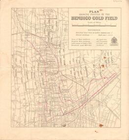
Map - BENDIGO GOLD FIELD - MAP OF PORTION OF THE BENDIGO GOLD FIELD
Map showing portion of the Bendigo Gold Field showing Alluvial working, shaft sites , streets and lines of reefs.Department of Mines, Victoria. Many mines, lines of reefs and gullies are on the map. Blue Royal Historical Society of Victoria Bendigo Branch stamp on the back.document, bendigo gold field, department of mines, lines of reefs, gullies, mines -
Bendigo Historical Society Inc.
Map - TOOLLEEN : COUNTY OF BENDIGO, 25-5-26
Map. Toolleen, County of Bendigo, County of Rodney, Campaspe, Colbinabbin, Cornella, Crosbie, Muskerry, Mount Pleasant Creek, Township of Toolleen. By authority H.J. Green, Govt. Printer. Photo-Lithographed at the Department of Lands and Survey, Melbourne by W.J. Butson, 25-5-26. (number 105 in map cupboard 1)H.J. Green, Govt. Printer.map, bendigo, toolleen -
 Marysville & District Historical Society
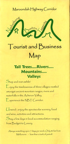
Map (Item) - Tourist and business map, Narbethong Community and Tourism Group, Narbethong Buxton Taggerty Tourist and Business Map, 04-2008
A tourist and business map of Narbethong, Buxton and Taggerty. This map was produced by the Narbethong Community and Tourism Group in April 2008. It was produced to promote the natural attractions, adventure activities and food trail from the Black Spur, through Narbethong, Buxton and Taggerty.A tourist and business map of Narbethong, Buxton and Taggerty.This publication has been produced by the Narbethong Community and Tourism/ Group (NCTG) to promote the natural attractions, adventure activities and food/ trail from the Black Spur, through Narbethong, Buxton and Taggerty./ the information provided in this publication has been supplied by the individual/ members. NCTG takes no responsibility for its accuracy./ April 2008narbethong, buxton, taggerty, victoria, australia, tourist and business map, narbethong community and tourism group, acheron valley, yarra track, wood's point, black spur, mystic mountains, the meeting of the waters, cathedral range, danico design counted cross stitch, things of sand & stone, buxton zoo nursery & oddz & enz, willowbank at taggerty, safe trek 4wd services, pnl 4wdriving, buxton trout and salmon farm, mystic mountains ski hire & outdoors, narbethong ski hire, highwood health centre, cathedral view natural therapies, narby cabinets, plants by shelian, gb timber, executive signs, rb automotive repairs, buxton car care, marysville towing & equipment hire, martyn slade building design, cathedral peak framing, black spur roadhouse & ski hire, tudor lodge roadhouse & ski hire, buxton roadhouse & persian bazzar, buxton post office general store & niche bar, igloo roadhouse, taggerty store, narby eggs, marapana agistment park, mantirri blueberry farm, carmyle farm, hazelwood hazelnuts, south cathedral lavender farm, cathedral cherries, black spur motel & caravan park, woodlands rainforest retreat, chestnut glade, black spur inn, wombat cottage, abbey lake luxury b & b spa cottages, blue views holiday cottages, camp narbethong, marapana farm stay b & b, mantirri blueberry farm b & b, little dene garden cottages, silverstream b & b cottages, nareen cabins, moondai farm b & b, south cathedral farm luxury b & b cottages, yarrolyn caravan park, sarsens rest, lomah retreat, pinjarra gardens, kingbilli country estate, henry viii manor house, buxton hotel, butters cafe of buxton, wagtail wines, little river wines, lanterns at willowbank, wirrawilla rainforest walk, wilhemina falls, the cascades -
Port Melbourne Historical & Preservation Society
Map - MMBW, 1895
MMBW 1895 Plan No's. 344 to 349 Segment: Ingles to Bridge, Nott to Esplanade East (on south) Scale 40ft=1" (large)311/H 22melbourne and metropolitan board of works, port melbourne town hall, built environment, business and traders - hotels -
 Bacchus Marsh & District Historical Society
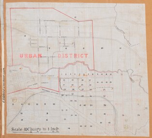
Map, Bacchus Marsh Urban District
The date of this map has not been established but the date would be sometime after 1887 as the Bacchus Marsh Railway Station, which opened in 1887, is shown on the map. A single page paper map showing blocks of land in the urban district of Bacchus Marsh. The 'urban district' is indicated by red drawn lines on the map and includes streets and blocks on the northern side of the Werribee River in Bacchus Marsh, and streets and blocks south of the Werribee in Maddingley. Scale 10 chains to 1 inch. The map is pasted into a bound volume containing 76 maps or plans in total. High resolution digital image stored on BMDHS computer network. bacchus marsh victoria maps, maddingley victoria maps -
![Parish of Nunawading, County of Bourke showing land acquired under Closer Settlement Acts [C 1887]](/media/collectors/56f368632162f118acbff12e/items/60d923316e5f99545134f182/item-media/6147b12a4806c7ae686c24e4/item-fit-380x285.jpg) Whitehorse Historical Society Inc.
Whitehorse Historical Society Inc.Map, Parish of Nunawading, ca 1887
Parish of Nunawading, County of Bourke showing land acquired under Closer Settlement Acts [C 1887]Parish of Nunawading, County of Bourke showing land acquired under Closer Settlement Acts [C 1887] 1947 reprint.Parish of Nunawading, County of Bourke showing land acquired under Closer Settlement Acts [C 1887] parish of nunawading, box hill, maps, land settlement -
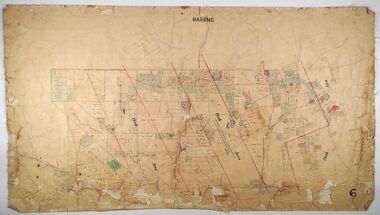 Bendigo Historical Society Inc.
Map - MARONG, Circa 1871
Map; Marong, Hand Draughted parish planmap, bendigo, parish plan, marong -
Whitehorse Historical Society Inc.
Map, Mitcham, 1880s?
Hand drawn map of area north and south of Whitehorse Road and South of Canterbury Road c.1880-1900.Hand drawn map of area north and south of Whitehorse Road and South of Canterbury Road c.1880-1900. Probably sketched by a McClare descendant. Includes locations and names of settlers of that time.Hand drawn map of area north and south of Whitehorse Road and South of Canterbury Road c.1880-1900. whitehorse road, mitcham, mitcham road, mitcham, l l vale road, vermont, canterbury road, mitcham -
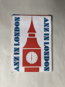 Robin Boyd Foundation
Map, ANZ in London; A map for visitors to London
walsh st library -
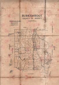 Bendigo Historical Society Inc.
Map - JACK FLYNN COLLECTION: BURRUMBOOT, August 1951
Map: Parish of Burrumboot, County of Rodney. Parish plan.By Authority J.J. Gourley, Government Printer Melbourne. Drawn and Reproduced at the Dept of Lands and Survey, Melbourne, Victoria. August 1951map, rodney, parish plan, burrumboot, rodney -
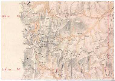 Bendigo Historical Society Inc.
Map - DIAMOND HILL AREA
Copy of map of Diamond Hill area, with the Trig Station mid centre on map. Shafts, mines and geological features are marked.bendigo, mining, diamond hill -
Moorabbin Air Museum
Map (item) - Map Gippsland
-
Stawell Historical Society Inc
Map, Parish of Stawell, Sheet 4, 1958
Parish of Stawell, Sheet 4stawell -
 Kew Historical Society Inc
Map, MMBW, River Yarra Beautification Schemes, c.1913
The Melbourne and Metropolitan Board of Works (MMBW) was established by an act of the Victorian Parliament in 1890 to prepare for and to implement a sewerage and water reticulation system across what was then inner Melbourne, its surrounding and middle distance suburbs, including Kew. The MMBW was disbanded in 1991.The map collection of the Kew Historical Society has at its core the historic maps assembled and originally stored in the City Engineer's Department of the City of Kew. These include maps in a number of scales. The vast majority of maps were produced by the MMBW in the first two decades of the twentieth century, and are solid working maps, backed by linen for durability. These maps are historically significant to Kew, the City of Boroondara and to the history of the development of state utilities in Victoria. A number of the Kew maps have additional details added by former municipal officers, including the levels reached by various floods. As these were working documents, information was added to them long after the period of their initial production and distribution.Map of the City of Kew showing part of the River Yarra Beautification Schemes. The map shows development to date and the flood levels reached in 1923 and 1924. This map may have been adapted from an earlier map, as most development in central Kew and Studley Park had occurred by this date yet numerous streets are not represented. Public buildings and institutions are clearly represented and named on the map as are significant public transport infrastructure (eg the Outer Circle railway).MELBOURNE AND METROPOLITAN BOARD OF WORKS / RIVER YARRA BEAUTIFICATION SCHEMES / SCHEME / SCALE 10 CHAINS TO AN INCHmelbourne & metropolitan board of works, mmbw maps, mmbw plans, city of kew, flood levels -- kew (vic.), cartography -
Beechworth Cemetery Trust
Map - Beechworth Cemetery reproduction of original map -Secretary copy, Beechworth Cemetery
Reproduction map displaying all grave sites in Beechworth Public Cemetery. Rotunda, fountain, nursery, memorial wall, pioneer sectionmap displays the plan of grave sitesLaminated Photocopy of original cemetery map with additional information hand-written on the map. All graves at the cemetery set out in denominational sections with hand-written information on additional graves added to sections in Roman Catholic A & C, Church of England A-F, Presbyterian A-C, Methodist/Uniting B and Wesleyan A. Multidenominational hand-written note on Jews section with Trust Minutes 4.7.'83 written next to this addition. Additions hand-drawn of fountain, memorial wall, nursery and pioneer cemetery.rotunda, fountain, nursery, memorial wall, pioneer section, graves, chinese section, un-numbered grave sites, cemetery -
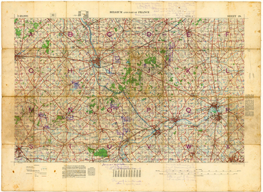 Whitehorse Historical Society Inc.
Map - Belgium and part of France map WW1, Belgium and part of France map WW1with penciled annotations by Charles H. Honybun, Nov 1917
WW1 map of Ypres and Menin. Sheet 28 Edition 3 Scale 1: 40,000 Nov 1917Map bounded by Balleul, Poperinghe, Ypres, Menin, Moorsele, Tourooingnon-fictionWW1 map of Ypres and Menin. Sheet 28 Edition 3 Scale 1: 40,000 Nov 1917world war 1914 - 1918, world war 1914 - 1918 battle of ypres, maps -
Canterbury History Group
Map - Canterbury. Sale of the season, c1929
Photocopy of sale notice for 28 mansion and villa sites in area bordered by Kent Avenue, Mont Albert Road, Faversham and Chatham Roads 29 September [1929]canterbury, mont albert road, faversham road, kent avenue, chatham road, flere & co, land subdivision, auctions -
Merbein District Historical Society
Map, White Cliffs Irrigation Settlement - Plan of Homestead Allotments, 1917
blocks, irrigation, parish of merbein, homestead allotments -
Stawell Historical Society Inc
Map, Kara Kara, Sheet One of Two, 1958 & 1959
Kara Kara, Sheet One of Twostawell -
Clunes Museum
Map - DOCUMENTS/MAP, 3 1887. .4 1891
MINING, CLUNES GOLD MINES, MAPS, SECTIONS.1 AERIAL VIEW OF CLUNES AND DISTRICT. COLOUR PHOTOGRAPH LAMINATED. .2 MAP OF MINING AREAS SHOWING EXCISED AREA. No. 9104. MINING DISTRICT OF BALLARAT. PARISH OF CLUNES. COUNTY OF TALBOT. SCALE 4 CHAINS TO AN INCH. .3 MAP OF GOLD MINING LEASE BLOCKS AT CLUNES .4 DRAWINGS OF SECTIONS, CLUNES GOLD MINES. SCALE 400 FEET TO AN NCH. ALL MOUNTED WITH PLASTIC HANGING STRIPS..1 ON BACK. CLUNES 1:25000 .2 ASSORTED HANDWITTEN NOTATIONS. .3 ASSORTED HANDWITTEN NOTATIONS. REPLACE IN DEPT. OF MINING REGISTRARS QUARTER ENDED 30TH JUNE 1887. P. 12.clunes, gold mining, leases, aerial photograph, mine sections -
Stawell Historical Society Inc
Map, Topographic Map Stawell South
Topographic Map 1:25000 Coloured 1990Stawell South 7423-1-Smapping -
Bendigo Historical Society Inc.
Map - CAMPBELL COLLECTION: BENDIGO AND DISTRICT MAPS, 8-2-29
Map. Bagshot, Parishes of Wellsford, Ellesmere and Bagshot. Scale 20 chains to 1 inch. Total area 5037 acres. Prepared in W.P.B. from A.C.l. and D.B. Plans, W.J. Galbraith, 8-2-29 (number 353 in map cupboard 1)W.J.Galbraithmap, bendigo, agricultural lands -
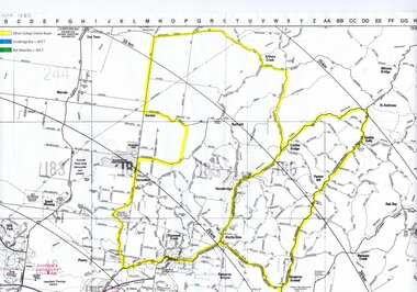 Greensborough Historical Society
Map, Greensborough c 1980s, 1980s
Map of Greensborough and surrounds showing bus routes servicing Eltham College.Map of Greensborough and surrounds, black print with colour markings."Bundoora Retirement Village" marked in red pen at E20greensborough - maps, eltham college, bus routes, public transport -
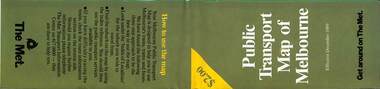 Melbourne Tram Museum
Map, The Met, Public Transport Map of Melbourne - Get around on The Met, 12/1989
Melbourne transport map - dated December 1989 - scratch ticket system, has a photo of the front of B2 2004, includes a map of the ticket zones, and The Met contact details.Yields information about Melbourne public transport services in December 1989 following the introduction of Scratch tickets.Fold out map (36 sections 9 across x 4 deep), "Public Transport Map of Melbourne", coloured of Melbourne's Tram and Bus routes, route numbers, rail lines, detailed for the central part of Melbourne and the outer Metropolitan services.tramways, melbourne, tram services, bus services, railways, maps, zones, scratch tickets -
Bendigo Historical Society Inc.
Map - CROSBIE : COUNTY OF BENDIGO, 28-9-76
Map. Crosbie, County of Bendigo, County of Rodney, Mt. Pleasant Creek, Weston, Toolleen, Redcastle, Dargile, Knowsley East. W.E. Porter, draughtsman, August 1878. Photo-Lithographed at the Department of Lands and Survey, Melbourne, J. Noune,28-9-76. (number 113 in map cupboard 1)W.E. Porter, Draughtsmanmap, bendigo, crosbie -
Canterbury History Group
Map - Elgar's Special Survey, copied 1989
Map of "Elgar's Special Survey" 8 square miles chosen by Henry Elgar in 1841, showing the location of J.B.Maling's Paddock and house, 13 acres bought in 1864.camberwell, balwyn, deepdene, canterbury, surrey hills, elgar's special survey, land subdivision, maps, maling family -
Whitehorse Historical Society Inc.
Map, Schwerkolt property by Arthur Schwerkolt, 1993
Map of Schwerkolt property and rough plan of original stone house produced by Arthur Schwerkolt. Also copy of covering letterschwerkolt cottage -
Stawell Historical Society Inc
Map, Stawell Gold Mine, Three dimensional View of Magdala Decline, March 1994
View of Mine looking from Stawell Hospital towards Big Hill Levels indicate depth in metres below hillParallel View Scale 1 : 2600mining, gold