Showing 2333 items in the category Documentation with item type Map
-
 Stawell Historical Society Inc
Map, Stawell Gold Mine, Milling Area Site Arrangement 2002, 12/6/2002
Plus Bench Mark Levels Stawell Gold Mines Victoria Scale 1 : 20000mining, gold -
 Bendigo Historical Society Inc.
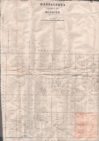
Map - MAP. WARRAGAMBA. COUNTY OF BENDIGO, 1915
Map. Warragamba. Colunty of Bendigo. Pannoomilloo. Minto. Diggorra. Kamarooka Photographedat the Department of LANDS AND Survey Melbourne by W. J. Butson. -
Bendigo Historical Society Inc.
Map - SANDHURST SHEET 2, No date visible
Map:Sandhurst, County of Bendigo Sheet 2. Parish plan, Eaglehawk. ( number 200 in Map Cupboard 1)map, bendigo, city streets, sandhurst -
 Bendigo Historical Society Inc.
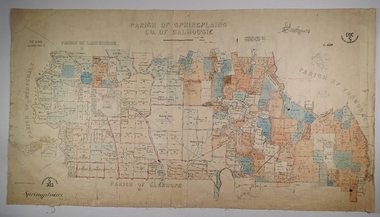
Map - SPRING PLAINS, Examined 31/01/1876
Map: Parish of Springplains, County of Dalhousie. Parish plan June 1874 A.D. Scott Examined E.D. 4.7.74 Additions made March 1877 Written in blue " See new plan."map, dalhousie, parish plan, spring plains, a. d. scott -
Stawell Historical Society Inc
Map, H C Bates Surveyor, Plan of Underground Workings. 1888, 25/8/1888
goldMagdala Co Now Moonlight Co StawellScale 80ft to an inch H C Bates Mining Surveyor 25/8/88mining -
 Whitehorse Historical Society Inc.
Map - WW1 map of France, WW1 map of France - regional. Field Survey Map of Enemy Rear Organisation, 08/10/1918
Enemy Rear Organisation map Scale 1 : 40,000Field Survey Map of Enemy Rear Organisationnon-fictionEnemy Rear Organisation map Scale 1 : 40,000maps, world war 1914 - 1918 -
Glenelg Shire Council Cultural Collection
Map - Map - Western Victoria / South Australia, n.d
Port of Portland Authority Archivesport of portland archives -
Clunes Museum
Map - CLUNES 1987, CHARLES FENTON, 1987
.1 .2 A MAP OF CLUNES TOWNSHIP - ORIGINAL AND COPY - 1987. ALL STREETS AND BIRCH'S CREEK MARKED WITH ALLOTMENT NUMBERS. .3 SAME MAP SHOWING PATH OF BUSHFIRE IN 1944CLUNES 1987local history, document, maps, clunes township -
 Ringwood and District Historical Society
Map, Plan of Subdivision - State School Estate, Ringwood East, Victoria - (Undated, circa 1920s)
Map of land for sale attached to green cardboard backing with handwritten notations showing numbered allotments on Dublin Road, Holland Road, King Street, Charles Street and Purser Avenue, Ringwood East.Locality plan includes reference to proposed Ringwood East railway station which opened in 1925. -
Bendigo Historical Society Inc.
Map - HUNTLY, 9th June 1880
Map:Huntly, County of Bendigo. Parish plan Canvas backed. ( number 138 in Map Cupboard 1)map, bendigo, city streets, huntly, county of bendigo -
 Bendigo Historical Society Inc.
Map - MARKS COLLECTION: GEOLOGICAL MAP OF IRELAND
Rolled map on wooden hanger, wooden rail on bottom. On top of map: 'geological survey of Ireland' On bottom LH side: the geology of this map published June 1855 by Sir R.I. Murchison, Director General, J. Beebe Jukes Local Director, surveyed by T. Oldham. Map part of Lansell material. On back of map at top written in black pen 'Ireland'.person, bendigo, george lansell -
 Bendigo Historical Society Inc.
Map - JACK FLYNN COLLECTION: VILLAGE OF BETLEY, 30/06/1874
Map: Village of Betley, on the Bet Bet Creek, Parish of Dunolly. Parish plan.Photo Lithographed at the Department of Lands and Survey Melbourne by J. Noone 30.6.74map, gladstone, village, betley, bet bet creek, dunolly -
Stawell Historical Society Inc
Map, The Litho Co Ballarat, Glyntowyn Estate Campbells Bridge 1909, 1909
Shows Hoestead CC McCulloch ESQPaper map / Poster Advertising Subdivision of EstateMitchell Bros & White. 5003 Acres The Litho Co Ballarat Black Printing with Red Coloured Sectionsfarming -
Bendigo Historical Society Inc.
Map - MAHER'S AND PRETTY'S ESTATE, 8/02/1926
Map: Maher's and Pretty's Estate, Parish of Toolamba West, County of Rodney. Parish plan Canvas backed. ( number 131 in Map Cupboard 1)map, rodney, rural, maher's , pretty's, toolamba west, county of rodney -
Moorabbin Air Museum
Map (Item) - Associated Area Terminal Charts - Various
-
Stawell Historical Society Inc
Map, Bellellen, County of Borung, 1952
Bellellen, County of Borungstawell -
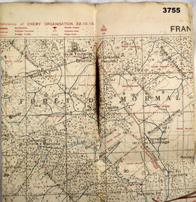 Bendigo Military Museum
Map - FIELD SURVEY MAP, FRANCE WW1, 1918
Area of map shows the River Sambre running from corner left to top corner right, Landrecies, Hachette, Petit Paris to Leval. Item re William Alexander No 502 AIF. refer cat No 3746.3 for his service details.Map, Enemy rear Organization France, Edition 3a, sheet 57A N.W, scale 1:20,000, Field Survey to 24.10.1918.Hand written on rear in black, “57A N.W”map, france, trench -
 Bendigo Historical Society Inc.
Map - GREAT EXTENDED HUSTLER'S MINE - TRANSVERSE SECTION OF THE GREAT EXTENDED HUSTLER'S MINE
Transverse Section of the Great Extended Hustler's Mine on the Hustler's Line of Reef. Bulletin No 33, Plate No XII. Shows Poppet legs at the surface and Sill of Shaft at 788.99 feet above Sea Level, Cross Cuts and their depths, stone and geographical features encountered and their references and a number of enlarged drawing of sections of the crosscuts, Geological Survey of Victoria emblem and signed by H A Whitelaw, Underground Survey Office Bendigo, September 1913. The depths of crosscuts to No 21 were taken from plans of surveys by Mr. Walker and Mr. Craven, noted under Reference. Another note: This Saddle Reef is sketched from Mr. Walker's plan. Dividends amounting to 360,000 pounds were obtained from it. mining, parish map, great extended hustler's mine, transverse section of the great extended hustler's mine, old shaft, mr walker, mr craven, geological survey of victoria, underground survey office bendigo, h a whitelaw -
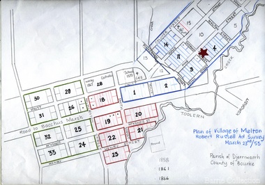 Melton City Libraries
Map, Plan for the Village of Melton, 1853
Site of early village Section numbers 1 - 17 Later became the Flat known as the Common Robert Russell – Surveyor Pinkerton, Sherwin, Bryan, Pyke, Yuille, CollyerMelton Town 1853 Plancouncil -
 Bendigo Historical Society Inc.
Map - HUSTLERS LINE OF REEFS - LONGITUDINAL SECTION THROUGH THE SADDLE REEFS
Drawing with Longitudinal Section through the Saddle Reefs along portion of Hustler's Line of Reefs, Bendigo. Map shows the depth of the mines, reef numbers and Datum 700 ft above sea level. North and South is also noted on the map. Map signed by H. S, Whitelaw, Underground Survey Office, Bendigo, September 1913. Bulletin No 33, Plate No XXXIV. Bendigo Creek, Ironbark Creek and Long Gully are also noted. Mines are: Fortuna Hustlers, Hustler's Royal Reserve No 2 Main Shaft, Hustler's Royal Reserve No 2 Park Shaft, Royal Hustler's, Imperial Hustler's, Extended Hustler's Freehold, Great Extended Hustler's Tribute (Pups), Old Shaft, Great Extended Hustler's Reef No 2, Great Extended Hustler's Main Shaft, Old Shaft, Hustler's Reef, Hustler's Reef No 1, Comet, K. K., United Hustler's & Redan, Old Shaft and Hustler's Consols. Has Geological Survey of Victoria Crest and underneath is: H. Herman, Director, W. Dickson, Secretary for Mines, The Hon. J Drysdale Brown M L C. Minister of Mines.Geological Survey of Victoria Crestmining, hustler's reef maps, hustlers line of reefs, bendigo creek, royal hustler's, imperial hustler's, extended hustler's freehold, great extended hustler's tribute (pups), great extended hustler's reef no 2, great extended hustler's main shaft, hustler's reef, hustler's reef no 1, united hustler's & redan, old shaft and hustler's consols.h s whitelaw, underground survey office bendigo september 1913 -
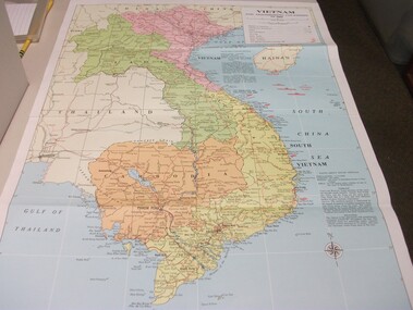 National Vietnam Veterans Museum (NVVM)
Map - Map, Vietnam and surrounding countries
Paper map of Vietnam, Laos, Thailand, Hainan Island, Cambodia & Burma. Coloured print, very detailed. Showing surrounding oceans & information on climate & population of North & South Vietnam.vietnam map -
Whitehorse Historical Society Inc.
Map, Burwood Road, Box Hill City, 15/02/1952 12:00:00 AM
Plan of subdivision of ten blocks in Burwood Road, Burwood.Plan of subdivision of ten blocks in Burwood Road, Burwood between Milford Avenue and Station Street. Marked as Survey Plan No 5441.Plan of subdivision of ten blocks in Burwood Road, Burwood. land subdivision, burwood road, burwood, milford avenue, burwood, central court, burwood -
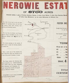 Bacchus Marsh & District Historical Society
Map, Nerowie Estate Land Sale 1910
The Nerowie Estate was a large rural property of 8,700 acres (3520 hectares) near the locality of Parwan only a few kilometers east of Bacchus Marsh. It had once formed a large part of the land owned by the pioneering Staughton family.A single page paper map showing the land offered for sale from the Nerowie Estate at Parwan near Bacchus Marsh in 1910. The map is pasted into a bound volume containing 76 maps or plans in total. High resolution digital image stored on BMDHS computer network. nerowie estate parwan, land sales parwan, land sales bacchus marsh, staughton family bacchus marsh -
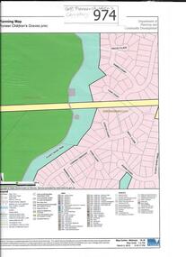 Greensborough Historical Society
Map, Pioneer children's graves precinct, 1848-1860
Map showing the location and surrounds of Pioneer Children's Cemetery on the Plenty River in Greensborough. Children from pioneer families are buried here.Official government planning map for the Pioneer Children's Graves Precinct.Printed coloured copy of map of Plenty River areapioneer childrens cemetery, greensborough, partington, whatmough -
 B-24 Liberator Memorial Restoration Australia Inc
Map - US World War II multi-coloured map, Side 1 - No. C-47 South Borneo, Side 2 - No. C-48 West Java, 1944
Silk and rayon maps were produced by the United States (c. 7.5 million in total), Great Britain (some 1.75 million in total) and Australia during World War II. They were issued to Allied military personnel as part of 'escape and evasion' kits.This map, printed on acetate rayon, is an original US 'escape and evasion' kit map from World War II.A multi-coloured, contoured, double-sided map printed on acetate rayon AAF Cloth Chart Side 1 - No. C-47 South Borneo Side 2 - No. C.48 West Javaunited states of america, silk and rayon maps, world war ii, a191 -
Whitehorse Historical Society Inc.
Map, City of Nunawading, n.d
Map of the City of Nunawading with streets and railway stations namedMap of the City of Nunawading with streets and railway stations named Scale 1 mile = 3.75 inMap of the City of Nunawading with streets and railway stations named city of nunawading, maps -
 Ballan Shire Historical Society
Map - Map. Bullarook State Forest, Bullarook State Forest Reserve
A small map of the Bullarook State Forest Reserve. Drawn on a fine buff coloured paper attached to a stiff cloth backing sheet. The title is hand written and includes a "scale one mile to one inch" hand written also. The map is signed "John Wrigglesworth, assistant ? and dated 26/6/1869" although the month and year are almost illegible.moorabool west, state forest, bullarook, eastern moorabool river, werribee river, moorabool east, blakes saw mill, wombat, andersons saw mill -
 Federation University Historical Collection
Map, Lancefield, 1947
Printed coloured map on paperlancefield -
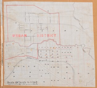 Bacchus Marsh & District Historical Society
Map, Bacchus Marsh Urban District
The date of this map has not been established but the date would be sometime after 1887 as the Bacchus Marsh Railway Station, which opened in 1887, is shown on the map. A single page paper map showing blocks of land in the urban district of Bacchus Marsh. The 'urban district' is indicated by red drawn lines on the map and includes streets and blocks on the northern side of the Werribee River in Bacchus Marsh, and streets and blocks south of the Werribee in Maddingley. Scale 10 chains to 1 inch. The map is pasted into a bound volume containing 76 maps or plans in total. High resolution digital image stored on BMDHS computer network. bacchus marsh victoria maps, maddingley victoria maps -
Stawell Historical Society Inc
Map, Department of Lands and Survey Melbourne, Swinton Estate. Parish of Riachella. County of Borong, 3-08-1921
Shows part of Warranook TrainwayA1 Printed Map With Cloth Backing. Annotations in Red Ink W.J. Butson 3-8-21farming