Physical description
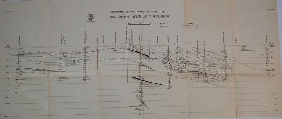
Drawing with Longitudinal Section through the Saddle Reefs along portion of Hustler's Line of Reefs, Bendigo. Map shows the depth of the mines, reef numbers and Datum 700 ft above sea level. North and South is also noted on the map. Map signed by H. S, Whitelaw, Underground Survey Office, Bendigo, September 1913. Bulletin No 33, Plate No XXXIV. Bendigo Creek, Ironbark Creek and Long Gully are also noted. Mines are: Fortuna Hustlers, Hustler's Royal Reserve No 2 Main Shaft, Hustler's Royal Reserve No 2 Park Shaft, Royal Hustler's, Imperial Hustler's, Extended Hustler's Freehold, Great Extended Hustler's Tribute (Pups), Old Shaft, Great Extended Hustler's Reef No 2, Great Extended Hustler's Main Shaft, Old Shaft, Hustler's Reef, Hustler's Reef No 1, Comet, K. K., United Hustler's & Redan, Old Shaft and Hustler's Consols. Has Geological Survey of Victoria Crest and underneath is: H. Herman, Director, W. Dickson, Secretary for Mines, The Hon. J Drysdale Brown M L C. Minister of Mines.
Inscriptions & markings
Geological Survey of Victoria Crest
Subjects
- mining,
- hustler's reef maps,
- hustlers line of reefs,
- bendigo creek,
- royal hustler's,
- imperial hustler's,
- extended hustler's freehold,
- great extended hustler's tribute (pups),
- great extended hustler's reef no 2,
- great extended hustler's main shaft,
- hustler's reef,
- hustler's reef no 1,
- united hustler's & redan,
- old shaft and hustler's consols.h s whitelaw,
- underground survey office bendigo september 1913