Showing 2323 items in the category Documentation with item type Map
-
 Canterbury History Group
Map - Canterbury subdivisions, 1996
Photocopy of map from Camberwell Library showing Canterbury subdivisions.canterbury, maps, land subdivisions -
Bendigo Historical Society Inc.
Map - BENDIGO GOLD FIELDS
Map, Bendigo Gold Fields, copy, mining leases, the numbers of their leases, as well as streets of Bendigo.( number 408 in Map Cupboard 1).bendigo, mining, mining leases -
 Bendigo Historical Society Inc.
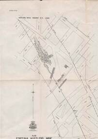
Map - STRUGNELL COLLECTION: HUSTLER'S LINE OF REEFS, BENDIGO, September 1913
Map, Hustler's Line of Reefs, Bendigo, Plan Fortuna Hustler's Mine, Hustler's Royal Reserve No. 2 Lease. Plate No.1(1) Bulletin No 33 Signed H.A.Whitelaw.Underground Survey Office, Bendigo.map, bendigo, fortuna hustler's mine -
 Bacchus Marsh & District Historical Society
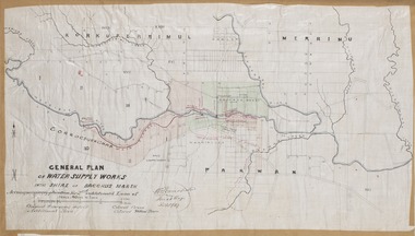
Map, General Plan for Water Supply Works, Shire of Bacchus Marsh 1887
Debate about water supply and its planning and development took place in the Bacchus Marsh region from the 1850s through into the twentieth century. This plan was part of documentation to support an application for an additional loan of money from the Ministry of Water Supply to the Bacchus Marsh Shire Water Supply Trust. The plan includes the route of a proposed water channel in the Parwan area, and other features of water supply infrastructure such as the location of standpipes and gates are also shown on the plan.A single page paper map showing a general plan for the supply of water in the Bacchus Marsh area.The plan shows the route of the 'Main Channel' near the Werribee River and a proposed route for a Parwan Channel. The location of 'Dryden's House' near the Werribee River is also shown and the locations of land held by T. (Tom) Oliver and the Racecourse Reserve in Maddingley. Scale 40 chains to 1 inch. The plan is signed by Bacchus Marsh Shire Engineer, W.E. Standfield. The map is pasted into a bound volume containing 76 maps or plans in total. High resolution digital image stored on BMDHS computer network. General Plan of Water Supply Works in the Shire of Bacchus Marsh. Accompanying application for 2nd additional Loan. Original Waterworks district. Additional area. W.E. Standfield, 30/8/87.water supply, water supply maps, water supply bacchus marsh, irrigation, bacchus marsh victoria maps -
Bendigo Historical Society Inc.
Map - TOWNSHIP OF HEATHCOTE SHEET 2, Circa 1935
Map: Township of Heathcote sheet 2. Parish plan (number 254 in map cupboard 1)map, dalhousie, township, heathcote -
Bendigo Historical Society Inc.
Map - BENDIGO SHEET 5, May 1949
Map: Bendigo sheet 5 . Parish plan ( number 209 in Map Cupboard 1)map, bendigo, parish plan, bendigo -
 Bendigo Historical Society Inc.
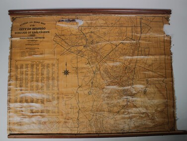
Map - Map of Bendigo streets
Situated at Cowlings Ford Dealership and Garage in Bendigo to enable employees to find streets from 1930 to 1970 when Cowlings closed.Paper on canvas wall map. Street and Road map of City of Greater Bendigo, Borough of Eaglehawk and Surrounding Districts. Wooden hanging rod on top edge. Wooden rod on lower edge has detached. Light brown background. Printed in black and red. Includes Street indexes, historical information and key to points of interest.eaglehawk, map, cowlings garage bendigo -
 Tatura Irrigation & Wartime Camps Museum
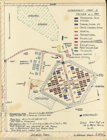
Map - Sketch Plan, Internment Camp 3 Tatura as in 1945, January 1992
Plan drawn from documents and memory by former internees Helmut Ruff and Manfred Haering. Sketch plan of Camp 3 Tatura layout as in 1945. Camp contained members of Palestine, Singapore/Straits Settlement & New Guinea Groups.Copy of black ink and coloured A3 plan mounted on hardboard showing layout of buildings and perimeter fencing of camp 3 Tatura. Original hand drawn.palestine group, singapore group, new guinea group, helmut ruff, manfred haering, camp 3 layout -
 National Vietnam Veterans Museum (NVVM)
Map
A laminated coloured map around the South China Seamap, 3rar, mcphail collection -
Port Melbourne Historical & Preservation Society
Map - Footscray, Public Lands Office, 19 Oct 1857
Map of Footscray, west of Saltwater Creek; south of Hopkins Street, east of Railway and north southern boundary of Botanical Garden reserve.The Township of Footscray, Parish of Cut-Paw-Pawfootscray -
Whitehorse Historical Society Inc.
Map, Melbourne and suburbs, 1923
Section of map 'Melbourne and Suburbs' compiled at the Department of Lands and Survey, Melbourne by E. S. Hilcke, March 1923, reprinted 1940.Section of map 'Melbourne and Suburbs' compiled at the Department of Lands and Survey, Melbourne by E. S. Hilcke, March 1923, reprinted 1940. Scale 40 chains: 1 inch. - Shire of Blackburn and MitchamSection of map 'Melbourne and Suburbs' compiled at the Department of Lands and Survey, Melbourne by E. S. Hilcke, March 1923, reprinted 1940.department of lands and surve, melbourne and suburbs -
Bendigo Historical Society Inc.
Map - DERBY, No date visible
Map: Derby. Hand draughted parish plan (number 303 in map cupboard 1)map, bendigo, parish plan, derby -
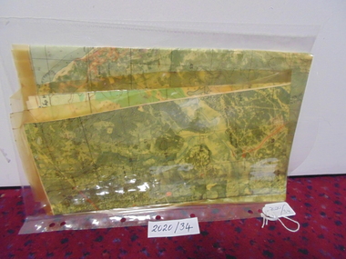
 Bendigo Historical Society Inc.
Map - BELLE VUE NO 2 - PLAN OF LEASES
BHS CollectionPlan of Mining Leases from Rowan Street to Long Gully. Reference J. N. Macartney 2nd Edition Bendigo Goldfields Registry for 1872. Names of Leases are: Moore ?, Ellesmere Co, Bonati & Co, Dennis, Abe Lincoln Co, Lansell & Hunt, Black & White Lead Co, Koch & Hildebrand, Ballerstedt, Lazarus Co No 1, Lazarus Co, Watson, Lazarus Freehold, Lazarus Co No 2, Lazarus Tribute, South Extended Burra, Endeavor Co, Old Chum Co, Burrows and Sterry, New Chum & Victoria Trib, Jackson, North Old Wybrants Chum Co, Myra Co, McLenn, Geary & Co, Western Victoria Hill G. M. Co, Victoria Reef G.M.Co, South Adventure Co, South Try Me Well, W. Rae, Wells Midway, Extended Co, Handy Andy, Moonta Co, Humboldt Co, Adventure Co, Try Me Well, Sterry & Co, Midway, Tudor, Friedman's Reef, Rising Sun, Try Me Luck, Pomponia, Confidence Co, Alfred Co, Advance Co, Prince Alfred Co, Canterbury Co, Platus Co, S. Platus Co, Golden Fleece United, Alfred Co, Iron Duke Co, Victoria Gold Mines Co, Hercules Co and Iron Bark. Notes prepared by Albert Richardson.map, bendigo, mining plan, belle vue no 2, no 2 belle vue new chum & c, j n macartney bendigo goldfields registry 1872, moore ?, ellesmere co, bonati & co, dennis, abe lincoln co, lansell & hunt, black & white lead co, koch & hildebrand, ballerstedt, lazarus co no 1, lazarus co, watson, lazarus freehold, lazarus co no 2, lazarus tribute, south extended burra, endeavor co, old chum co, burrows and sterry, new chum & victoria trib, jackson, north old wybrants chum co, myra co, mclenn, geary & co, western victoria hill g. m. co, victoria reef g.m.co, south adventure co, south try me well, w. rae, wells midway, extended co, handy andy, moonta co, humboldt co, adventure co, try me well, sterry & co, midway, tudor, friedman's reef, rising sun, try me luck, pomponia, confidence co, alfred co, advance co, prince alfred co, canterbury co, platus co, s. platus co, golden fleece united, alfred co, iron duke co, victoria gold mines co, hercules co, iron bark -
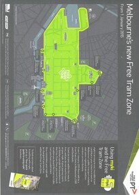 Melbourne Tram Museum
Map, Public Transport Victoria (PTV), "Melbourne's new Free Tram Zone", 2015
Printed A4 sheet - single sided off white sheet titled ""Melbourne's Free Tram Zone Map"., details the extent of the free tram zone or showing the tram lines that the free travel is allowed, locations, land marks, contact numbers and has the PTV logo in the top right hand corner and the Myki locos along with Yarra Trams and contact details for information. Dated 1/1/2015.trams, tramways, yarra trams, ptv, maps, free tram, melbourne -
Bendigo Historical Society Inc.
Map - CAMPBELL COLLECTION: BENDIGO AND DISTRICT MAPS, June 1953
Map. Marong, County of Bendigo, Scale 40 chains to 1 inch. Woodstock, Leichardt, Nerring, Sandhurst, Lockwood, Shelbourne. Drawn and reproduced at the Department of Lands and Survey, Melbourne, Victoria. By Authority : W.M. Houston, Government Printer. June 1953. Price 2/-. (number 403 in map cupboard 1)W.M. Houston, Government Printer.map, bendigo, agricultural lands -
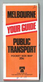 Melbourne Tram Museum
Map, Ministry of Transport, "Melbourne Transport Services Map - Tram, Train and Bus Services", 1977
Fold out map (27 sections 9 across x 3 deep), coloured of Melbourne's Tram and Bus routes, route numbers, rail lines, detailed for the central part of Melbourne and insert section for Frankston. On rear description of routes, private bus routes and map of Melbourne metro lines. Map No. 7, 1977. Has contact details for bookings and lost property etc. Priced 20c. 1977, route 59 showing as terminating opposite Essendon Airport.On front cover in ink "" in top right hand corner and "4 G 33 " along bottom edge.trams, tramways, melbourne, map, tram & bus services, railways, mmtb, minister for transport -
Whitehorse Historical Society Inc.
Map, Melbourne Metropolitan Area Base Map, 1957?
Sheet 254 of part of the Municipality of Nunawading and part of the Parish of Nunawading, showing roads, block numbers, creeks and contours mostly south of Canterbury Road.Sheet 254 of part of the Municipality of Nunawading and part of the Parish of Nunawading, showing roads, block numbers, creeks and contours mostly south of Canterbury Road. Prep. from State Aerial and Cadastral survey information, August 1957. Scale: 400 ft = 1 inchSheet 254 of part of the Municipality of Nunawading and part of the Parish of Nunawading, showing roads, block numbers, creeks and contours mostly south of Canterbury Road. city of nunawading, cadastral -
Bendigo Historical Society Inc.
Map - HEATHCOTE : COUNTY OF BENDIGO
Map. Heathcote, County of Bendigo, County of Dalhousie, Knowsley, Knowsley East, Dargile, Costerfield, Warrowitue, Tooborac, Langwornor, Argyle Station Ground, Bendigo to Heathcote to Kilmore Railway Line, Township of Heathcote, C.R.B. Main Road. Mount Ida Creek, Wild Duck Creek, Meadow Valley Creek. By Authority H.J. Green, Govt. Printer, Photo-Lithographed at the Department of Lands and Survey, Melbourne by W.J. Butson, Price 1/-. (number 91 in map cupboard 1)H.J. Green Govt. Printer.map, bendigo, heathcote -
 Bacchus Marsh & District Historical Society
Map, Pentland Hills Estate Land Sale 1904
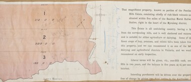
The Pentland Hills Estate property shown in this auction plan was put up for sale in 1904. It was a deceased estate sale. The property had been owned by Peter Grant who died in 1899. Peter Grant had worked and farmed in the Myrniong area for many years and had also been a Councillor on the Bacchus Marsh Shire for a number of terms. A property sales report in the Express newspaper recorded that the land for sale comprised 500 acres of the old Pentland Hills Estate. It was subdivided into three lots, all of which were sold at good prices. Lot l, 212 acres was sold to Messrs Thomas and Robert Lidgett of Myrniong, at £11/15/ per acre, lot 2, 200 acres, to Mr David Robertson, of Bacchus Marsh, at £9 17/0 per acre, and lot 3, 38 acres, was sold to Mr James Norton, jun at £11 per acre. A single page paper map showing a portions of land available for sale from the Pentland Hills Estate near Bacchus Marsh.The name of the seller, Mrs Grant, can seen handwritten on this map and the buyers of the three portions for sale, Lidgett lot 1, Robertson lot 2 and Morton lot 3. Parts of the text are missing along the edges due to tearing or excessive trimming of the edges. The map is pasted into a bound volume containing 76 maps or plans in total. High resolution digital image stored on BMDHS computer network. Handwritten: Mrs Grant, Myrniong, Executrix in the deceased Estate of Mr. Peter Grant to sell by public auction.land sales, pentland hills maps, myrniong area land sales, pentland hills estate -
 Whitehorse Historical Society Inc.
Map, Frank Ainger, 1873
Application by Frank Ainger for land in the Parish of Nunawading on Whitehorse Road near Mitcham Road. Also included are several references from other sources to Frank Ainger.ainger, frank, shire of nunawading, mitcham, land settlement -
Whitehorse Historical Society Inc.
Map, Sketch map, 1932
Sketch map of Doncaster, Mitcham and Tunstall. Scale 1 inch = 40 chains. 4th issue. 19 Apr 32Sketch map of Doncaster, Mitcham and Tunstall. Scale 1 inch = 40 chains. 4th issue. 19 Apr 32Sketch map of Doncaster, Mitcham and Tunstall. Scale 1 inch = 40 chains. 4th issue. 19 Apr 32maps, doncaster, mitcham, tunstall, nunawading -
 Bendigo Historical Society Inc.
Map - SPRING PLAINS, Examined 31/01/1876
Map: Parish of Springplains, County of Dalhousie. Parish plan June 1874 A.D. Scott Examined E.D. 4.7.74 Additions made March 1877 Written in blue " See new plan."map, dalhousie, parish plan, spring plains, a. d. scott -
 Melbourne Tram Museum
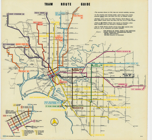
Map, Melbourne & Metropolitan Tramways Board (MMTB), "Tram Route Guide", Jun. 1979
Full colour map or poster printed on clear plastic with an adhesive peel off backing sheets, titled "Tram Route Guide". Map dated 6/79, showing proposed extension to Bundoora, routes with route numbers and names of main destinations. Has notes about the services, weekend and telephone numbers for information. 1979 Two copies held. See Reg Item 3765 for a larger version of this map.trams, tramways, mmtb, map, routes, posters -
Lakes Entrance Historical Society
Map - Oil Boring Lakes Entrance, 1935
Lease plan correct 9/9/1935Map showing where and the names of oil bores of Lakes Entrance. oil drilling, plan, local history -
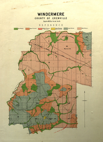 Federation University Historical Collection
Map, Windermere, County of Grenville
Coloured geological map of Windermere, County of Grenville. Scale is 40 chains to 1 inchwindermere, grenville, krause, plan, map -
Bendigo Historical Society Inc.
Map - GEOLOGICAL MAP: BENDIGO GOLD FIELDS
GEOLOGICAL MAP - BENDIGO GOLD FIELDS - Donated by JOHN HORWOOD. Two geological maps of the Bendigo Gold fields. The maps display , reef lines, Hills, Dams and mine locations. Also Anticlines, sinclines, shafts, alluvial deposits, contours and gullys. All items are superimposed on a map of the major roads and streets of Bendigo. The maps were printed by The Victorian Minister for Mines in 1923 and re-issued in 1936. The maps have been specifically framed and donated to The Bendigo Historical Society Inc. in May 2015 for display at Specimen Cottage. John had been a student at The School of Mines- Bendigo and found them useful as a student living in Bendigo. Prior to being framed , the maps have been kept rolled up in his home. Accession Number 309/15 Were on Display at Specimen Cottage 2015 - 2020. After all items removed from SC to the BRAC in 2021 the framed maps could not be located. Search ongoing. BP 2.3.2023Victorian Minister of Minesgoldfields -
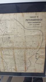 Peterborough History Group
Map - Map of the township of Peterborough, Township of Peterborough
Undated but indicative of the layout of the town. includes printed notes regarding the landscape and flora.Old map of the township of Peterborough from J S Irvine.A3 size paper map with tape around the sides. Includes handwritten notes.Handwritten on the rear is J.S Irvinepeterborough, old maps -
Bendigo Historical Society Inc.
Map - HARCOURT, September 1951
Map: Harcourt, County of Talbot. Parish plan ( number 177 in Map Cupboard 1)map, talbot, parish plan, harcourt, county of talbot -
Stawell Historical Society Inc
Map, Boroka, County of Borung, 1958
Boroka, County of Borung stawell -
Lakes Entrance Historical Society
Map - Colquhoun Counties of Tambo and Tanjil
Map showing original landowners of Colquhoun Countiesland settlement, records