Showing 2215 items
matching documentation
-
 Bendigo Historical Society Inc.
Map - PANNOOMILLOO : COUNTY OF BENDIGO, 17-12-13
Map. Pannoomilloo, County of Bendigo, Pannoobamawm, Warragamba, Milloo, Diggorra. Photo-Lithographed at the Department of Lands and Survey, Melbourne by W.J. Butson 17-12-13, Price 1/-. (number 82 in map cupboard 1)W.J. Butson.map, bendigo, pannoomilloo -
Stawell Historical Society Inc
Map, Glynwylln, Counties of Borung & Kara Kara, 1929
Glynwylln, Counties of Borung & Kara Karastawell -
 Kew Historical Society Inc
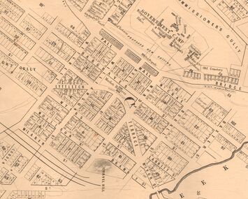
Map, MMBW, MMBW Plan No.67 Kew, 1900-1910
The Melbourne and Metropolitan Board of Works (MMBW) was established by an act of the Victorian Parliament in 1890 to prepare for and to implement a sewerage and water reticulation system across what was then inner Melbourne, its surrounding and middle distance suburbs, including Kew. The MMBW was disbanded in 1991.The map collection of the Kew Historical Society has at its core the historic maps assembled and originally stored in the City Engineer's Department of the City of Kew. These include maps in a number of scales. The vast majority of maps were produced by the MMBW in the first two decades of the twentieth century, and are solid working maps, backed by linen for durability. These maps are historically significant to Kew, the City of Boroondara and to the history of the development of state utilities in Victoria. A number of the Kew maps have additional details added by former municipal officers, including the levels reached by various floods. As these were working documents, information was added to them long after the period of their initial production and distribution.Early map of part of the Borough of Kew, created in the first decade of the twentieth century, at a scale 160 ft to 1 inch. The map covers what was then the north central part of Kew, bordered on its north by the Outer Circle Railway Spruzen and Beresford Avenues, in the west by Princess Street, in the south by High Street, and in the east by (about) Belford Road. The map shows the extent of urban development by that time, prominent institutions and the outlines of built structures in the municipality. Contour lines were added in ink to the map at a later stage.MELBOURNE AND METROPOLITAN BOARD OF WORKS / PLAN NO. 67 / KEW melbourne & metropolitan board of works, mmbw maps, mmbw plans, borough of kew, cartography -
 Melbourne Tram Museum
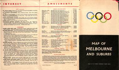
Map, Victorian Government Tourist Bureau, "Map of Melbourne and Suburbs", Jul. 1956
Map - .folded 12 sections full colour titled "Map of Melbourne and Suburbs". Issued at the time of the Melbourne Olympics by the Victorian Government Tourist Bureau. Has an index of Melbourne's suburbs, transport links, Places of Interest, Amusements, Facts of interest about Victoria. Major map shows the rail and tram lines, the detailed map of the CBD shows the buildings or locations referenced in the Tourist Guide to the City. Printed by the Victorian Railways - 2133-56trams, tramways, map, olympics, public transport, melbourne -
Whitehorse Historical Society Inc.
Map, Eastern Suburbs, 1922
Enlargement of sections of 1922 Ringwood Commonwealth Survey - Imperial General Staff (West - Camberwell; North - Templestowe; East - Ringwood; South - Clayton)maps, nunawading, tunstall, box hill, blackburn, mitcham, vermont, burwood east, mont albert -
Bendigo Historical Society Inc.
Map - HAYANMI, 16/05/1879
Map: Hayanmi, County of Bendigo. Parish plan (number 294 in map cupboard 1)map, bendigo, parish plan, hayanmi -
Bendigo Historical Society Inc.
Map - LYELL, 4/06/1873
Map: Lyell. Parish plan (number 278 in map cupboard 1)map, bendigo, parish plan, lyell -
 Bendigo Historical Society Inc.
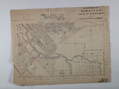
Map - NEWSTEAD ALLOTMENTS, 10/06/1886
Map: Town ans Suburban Lots, Newstead, Parish of Strangwaysmap, allotments, newstead , allotments, parish of strangways -
Bendigo Historical Society Inc.
Map - EGERTON, 13/05/1879
Map: Egerton, County of Bendigo. Parish plan ( number 236 in Map Cupboard 1)map, bendigo, parish plan, egerton -
 Ringwood and District Historical Society
Map, Partially Trimmed Copy of Elphin Estate, Ringwood, Vic. - (Undated, circa 1940s)
Clipped subdivision map on cardboard backing.Faint handwritten sales notations on and around numbered allotments in Heywood Street, Maidstone Street and Barkly Street, Ringwood.Surrounding streets also include Lutchie Street (later Sylvia Grove) and incorrect spelling of Barkly Street as Barkley. -
Beechworth Cemetery Trust
Map - Beechworth Cemetery reproduction of original map - On site in Rotunda, Beechworth Cemetery
Reproduction map displaying all grave sites in Beechworth Public Cemetery. Rotunda, fountain, nursery, memorial wall, pioneer sectionmap displays the plan of grave sitesLaminated Photocopy of original cemetery map with additional information hand-written on the map. All graves at the cemetery set out in denominational sections with hand-written information on additional graves added to sections in Roman Catholic A & C, Church of England A-F, Presbyterian A-C, Methodist/Uniting B and Wesleyan A. Multidenominational hand-written note on Jews section with Trust Minutes 4.7.'83 written next to this addition. Additions hand-drawn of fountain, memorial wall, nursery and pioneer cemetery.rotunda, fountain, nursery, memorial wall, pioneer section, graves, chinese section, un-numbered grave sites, cemetery -
Bendigo Historical Society Inc.
Map - CAMPBELL COLLECTION: BENDIGO AND DISTRICT MAPS, 23-4-29
Map. Whirrakee, Parish of Whirrakee, Total area 4419 acres, scale 20 chains to 1 inch. Unused water race in centre of map. Eucalypt Oil Distillery, bottom of map. Prepared in W.P.B. from Assessor's Plan and Parish Plan. G.W.Latimer 23-4-29. (number 385 in map cupboard 1)G.W.Latimermap, bendigo, agricultural lands -
 Bendigo Historical Society Inc.
Map - SANDHURST, SHEET ?, Date missing
Map: Sandhurst (sheet No., Missing) P_arish planmap, bendigo, parish plan, sandhurst -
Bendigo Historical Society Inc.
Map - ELMORE, 2/03/1880
Map: Parish of Elmore, County of Bendigo. Parish plan. (number 344 in map cupboard 1)map, bendigo, parish plan, elmore -
Bendigo Historical Society Inc.
Map - KANGAROO FLAT SUBDIVISION, 26/11/1900
Map: Plan of Subdivision at Kangaroo flat, Parish of Sandhurst, County of Bendigo ( number 149 in Map Cupboard 1)map, bendigo, parish plan, kangaroo flat, parish of sandhurst, county of bendigo -
Port Melbourne Historical & Preservation Society
Map - "The Township of Sandridge", Public Lands Office, 1859
Photocopy 1859 map of township of Sandridgelocal government - municipal district of sandridge, frank callaghan -
 Melbourne Tram Museum
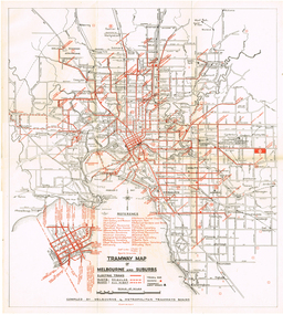
Map, "Tramway Map of Melbourne and Suburbs", c1952
Map of Melbourne's Tram and Bus routes, route destinations, MMTB Guest houses, all-night bus routes, depots, golf links and sporting grounds, rail lines, and location of major places of interest. Titled - "Tramway Map of Melbourne and Suburbs" - c1952, after the La Trobe or Latrobe St lines opened. Not known who produced the map. Does not give route numbers. See also Reg Item 2300 for an MMTB Map of the same era, 7315 for a similar version but without the guest houses, and 4525.1 for an MMTB Photograph.Yields information about Melbourne tram routes prior to Bourke St being built.Fold out map (6 sections), two colours. Has been removed from a book with the remnants of other paper in the top left-hand side.trams, tramways, melbourne, map, tram & bus services, all night services, mmtb, guest houses -
 Dandenong/Cranbourne RSL Sub Branch
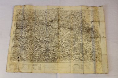
Map - Map of St Omer-France
-
Bendigo Historical Society Inc.
Map - BENDIGO, GREATER CITY OF, 2013
Map, City of Greater Bendigo, Epsom/Huntly, Heathcote, Strathfieldsaye/ Junortoun, Mandurang, Sebastian, Mia Mia, Maiden Gully, Ravenswoon, Axedale, Myers Flat, Redesdale, September 2013, on front. Lockwood South, Marong, Raywood, Neilborough, Elmore, Goornong, on reverse side. ( number 413 in Map Cupboard 1 ). Donated by Bendigo Council.bendigo, hospital -
Bendigo Historical Society Inc.
Map - Map of Lake Eppalock shoreline when empty
John Perry Collection. Laminated copy of map detailing Lake Eppalock shoreline when empty. Circa 1951. Has colored highlighter lines following roads leading to lake shoreline and various inundated old roads and tracks on lakebed. The dam was built by the State Rivers and Water Supply Commission of Victoria. The dam wall height is 45 metres (148 ft) and the main embankment is 1,041 metres (3,415 ft) long. At 100% capacity the dam wall was designed to hold back 304,651 megalitres (6.7014×10¹⁰ imp gal; 8.0480×10¹⁰ US gal) of water. The surface area of Lake Eppalock is 3,011 hectares (7,440 acres) and the catchment area is 2,124 square kilometres (820 sq mi). The controlled spillway is capable of discharging 8,040 cubic metres per second (284,000 cu ft/s). Lake Eppalock supplies both stock and domestic water to the Campaspe irrigation district. It also serves as a water supply to Bendigo and Heathcote and, in more recent times, Ballarat. The lake is a major attraction for those engaging in watersports, with a number of tourist parks and accommodation facilities available. Permissible activities on the lake include high-speed boating, water skiing, sailing, canoeing, fishing and swimming. The lake's water levels were low for approximately eight years between 2002 and 2010 during a prolonged drought, which restricted the amount of recreational activity until rainfall in the latter half of 2010 returned the lake to 100 percent capacity. Built between 1961 and 1964, Lake Eppalock remains the only water storage on the Campaspe River system.map, eppalock, reservoir, lake, water -
Glenelg Shire Council Cultural Collection
Map - Fold-out Tourist Map of Portland and District, n.d
Black and white fold-out map of Portland District. reverse has maps of Portland and Mt. Gambier, plus tourist information about points of interest in both towns. When folded, photo of Cape Nelson lighthouse on front. -
 Bendigo Historical Society Inc.
Map - MARKS COLLECTION: MAP SANDHURST 1867
Original map: Sandhurst 1867, shows central Bendigo and surrounds, including police camp, stockade, 'old cemetery', reserve for. On bottom of map: 'Lithographed at the Department of Lands and Survey by D. Henderson, 20 February, 1867'. On top RH corner 'Sheet No 1 Sandhurst'.map, bendigo, 1867 sandhurst map -
Port Melbourne Historical & Preservation Society
Map, John Millar, "Design for Ship Canal or 'tidal harbor' and docks for the Port of Melbourne", 21 Sep 1860
COPYRIGHT STATE OF VICTORIA Hydrographic map. "Design for Ship Canal or 'tidal harbor' and docks for the Port of Melbourne". Shows proposed extension of the city westward. Signed 21.09.1860, lithographed 21.12.1860 and reproduced 1986transport - shipping, piers and wharves, engineering - canals and drainage, town planning -
 Bacchus Marsh & District Historical Society
Map, Allotments in the Village of Rowsley, Parish of Gorrocburkghap, County of Grant c.1856
Rowsley is a locality 11 kilometers south-west of Bacchus Marsh. The date of this map is uncertain. A very similar map held by the State Library of Victoria (SLV) contains slightly more information than this copy and is dated as an 1856 map. SLV reference: 'Allotments in the Village of Rowsley, Parish of Gorrocburkghap, County of Grant', by T. Nixon, Assistant Surveyor, May 1856 ; Surveyor General’s Office, July 18 1856 (lithographed by R. Meikle). (1856). Melbourne: Surveyor General’s Office. MAPS 820 BJE 1837- ROWSLEY 1856. A single page paper map. A cadastral map of the Village of Rowsley in Victoria, showing numbered land allotments. 57 allotments are shown on the map and some areas set aside as reserves. Allotments 8, and 10-16 are outlined in red ink and allotment 9 has a cross in red ink on it. The map is pasted into a bound volume containing 76 maps or plans in total. High resolution digital image stored on BMDHS computer network. rowsley victoria history, rowsley victoria maps -
 Melbourne Tram Museum
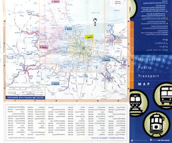
Map, Department of Infrastructure (DOI), "Melbourne's Public Transport Map", Jul. 1999
Map - 18 fold - 6 x 3 with colour map of public transport including buses, titled "Melbourne's Public Transport Map", published by the Department of Infrastructure, Effective July 1999. Gives rail and tram maps, information on tickets, zones (3 Number) Has The Met contact details and website. Has DOI and State Govt logos. Priced $2.trams, tramways, map, doi, melbourne, the met