Showing 2323 items in the category Documentation with item type Map
-
 Queenscliffe Maritime Museum
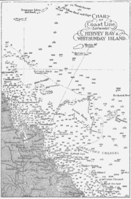
Map - B & W coastal map between Hervey Bay & Whitsunday Island, in Queensland, Coastal map, Queensland, between Whitsunday Island & Hervey Bay, Before donation in 1987
Australian coastal mapsAustralian coastal mapsCoastal 'soundings' map between Hervey Bay & Whitsunday Island, in Queensland, from an unknown book, pre-1987Reverse " NIL "old maps of australian coast -
 Peterborough History Group
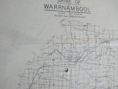
Map - Shire of Warrnambool East Riding
Contextual location of Peterborough town within the shire at that time, including local roads.Historic informationA3 size map of the Warrnambool Shire East Riding, includes landscape details, and the location of town in the Shire.Irvine written in pencil on the backpeterborough, curdies river inlet, old maps, warrnambool shire map -
 National Vietnam Veterans Museum (NVVM)
Map
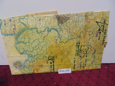
A large laminated coloured map of Joint Operations Graphic (ground), Vietnam. there are specific information highlighted in pen.3rar, mcphail collection, map -
 Port Melbourne Historical & Preservation Society
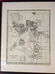
Map - Plan of Melbourne, 1855
Framed copy of 1855 "Plan of Melbourne and its suburbs". Black frame. Some writing can be seen on left hand side of print.built environment, melbourne and metropolitan board of works -
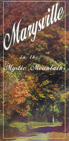 Marysville & District Historical Society
Map (Item) - Information brochure, Project Art & Photo, Marysville in the Mystic Mountains, Unknown
An information brochure on Marysville, the surrounding district and the natural attractions in the region published by Mystic Mountains Tourism.An information brochure on Marysville, the surrounding district and the natural attractions in the region published by Mystic Mountains Tourism.marysville, victoria, australia, information brochure, mystic mountains, mystic mountains tourism, cathedral range, lady talbot drive, cameron cascades, phantom falls, keppel falls, beech forest cascades, the beeches rainforest walk, the big tree, cumberland memorial scenic reserve, cambarville, cumberland falls, cora lynn falls, the big culvert, steavenson falls, lake mountain, marysville visitor information centre -
 Canterbury History Group
Map - Victorian Railways, Sheet no.10 , Hawthorn to Canterbury, 1/02/1914 12:00:00 AM
Map of Canterbury Railway Station and its surrounds, includes railway lines and station yards and may houses in nearby streets, February 1914.canterbury, canterbury railway station, canterbury road, maling road, bowling green, canterbury gardens, stationmasters houses, scott crescent, victorian railways -
Bendigo Historical Society Inc.
Map - LYELL, 4/06/1873
Map: Lyell. Parish plan (number 278 in map cupboard 1)map, bendigo, parish plan, lyell -
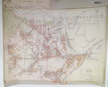 Bendigo Military Museum
Map - Map of Newcastle NSW 4 Inch - 1 Mile 1910, Australian Intelligence Corps, Nov 1910
In 1909 the Australian Army Headquarters realized that mapping in Australia was either non existent or inadequate for Military use. It was requested that Australia borrow Survey personnel from the UK Royal Engineers (RE) for a two-year detachment. On 11 April 1910 four RE NCOs arrived in Melbourne comprising CPL J Lynch, and LCPLs AH Barrett, EF Davies and R Wilcox. LCPL Barrett had 12yrs experience with RE. They were aiming at producing eight map sheets per year covering about 7,000 square miles (18,000 square Km) This map sheet of the Newcastle area was produced using plane table methods and was surveyed and hand drawn by LCPL A Barrett Oct - Nov 2010. It was unique because it was now produced on an accurate gridded base and included contouring. Lynch and Davies transferred to the Royal Australian Engineers (RAE) whilst Barrett and Wilcox returned to the UK in June 1913. Barrett returned to Australia in 1915 and also enlisted in the RAE and served until 1919.A gridded Map of Newcastle NSW area scale four inches to one mile with 25 feet interval contouring. Coloured hand drawn map produced in 1910. Signed by " A Barrett LCPL Royal Engineers"royal australian survey corps, rasvy, fortuna, army svy regt, army survey regiment -
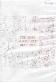 Bendigo Historical Society Inc.
Map - BENDIGO GOLDFIELD MAP 1913, 1913
DVD. Bendigo Goldfield Map 1913. -
Bendigo Historical Society Inc.
Map - SEDGWICK, 5/04/1881
Map: Parish of Sedgwick, County of Bendigo. Parish plan (number 312 in map cupboard 1)map, bendigo, parish plan, sedgwick -
Bendigo Historical Society Inc.
Map - SALISBURY WEST : COUNTY OF BENDIGO, 24-6-24
Map. Salisbury, County of Bendigo, County of Gladstone, Powlett, Yarrayne, Bridgewater, Inglewood, Glenalbyn, Kurting, River Loddon, Bulabul Creek. By authority A.J. Mullett, Government Printer, Melbourne. Photo-Lithographed at the Department of Lands and Survey, Melbourne by W.J. Butson, 24-6-24. Price 1/-. (number 116 in map cupboard 1)A.J. Mullett, Government Printer, Melbourne.map, bendigo, salisbury west -
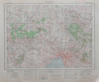 Federation University Historical Collection
Map, Melbourne, 1943, 1943
2 copies of printed colour map on papermelbourne -
Bendigo Historical Society Inc.
Map - CAMPBELL COLLECTION: BENDIGO & DISTRICT MAPS, 16-5-29
Map. Egerton, Parishes of Egerton and Whirrakee, scale 20 chains to 1 inch. Total area 5401 acres. Prepared in W.P.B. from A. and C.L. Plans by W.J. Galbraith (number 376 in map cupboard 1)W.J.Galbraithmap, bendigo, agricultural lands