-
 Eltham District Historical Society Inc
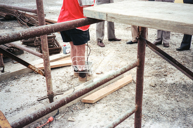
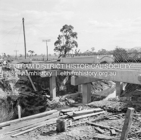
Negative - Photograph, Construction work, Main Street Bridge, Greensborough, c.Dec. 1983
The original bridge over the Plenty River was replaced by a single lane bridge each way fed by two lanes each way on either side. As traffic grew a second bridge was added to complete the divided road across the riverFilm - Kodak CM 400 5079 7 strips, 26 framesinfrastructure, roads, bridge construction, greensborough, main street bridge, road construction -
 Eltham District Historical Society Inc
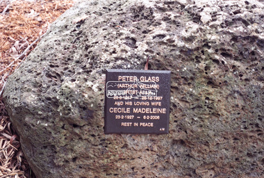
Negative - Photograph, Harry Gilham, Memorial for Peter Glass and Cecile Madeleine Glass, Eltham Cemetery, 1 Aug 2007
Peter Glass (Arthur William) Artist A.I.L.A. 28.8.1917 - 28.12.1997 And his loving wife Cecile Madeleine 23.2.1927 - 6.2.2006 Rest In Peaceeltham cemetery, gravestones, memorials, cecile madeleine glass, peter glass -
 Ballarat Tramway Museum
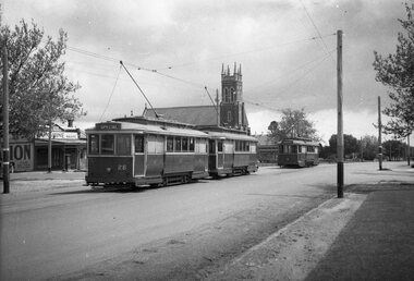
Negative, Wal Jack, late 1940's?
Yields information about the Victoria St line and the use of King St loop and special trams.Negative and Digital image of the Wal Jack Ballarat Negative file of No. 26 west bound (showing Special) nearing the King St Loop in Victoria St. In front of the tram is No. 20? and No. 28 (Special) in the loop. Has the St Alipius church in background and a general store advertising Sunshine biscuits, operated by Stan ?owsell. Has a letter box under the verandah. See Reg Item 7633 - likely to have been taken at the same time.trams, tramways, victoria st, king st, tram 26 tram 20? tram 28 -
 Eltham District Historical Society Inc
Negative - Photograph, Water treatment plant at Kangaroo Ground end of Maroondah Aqueduct tunnel, 1991
Roll of 35mm colour negative film, 9 strips Colour print 10 x 15 cmFuji HG 200 CA-1kangaroo ground, maroondah aqueduct, water treatment plant -
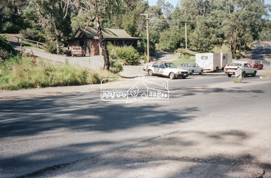 Eltham District Historical Society Inc
Negative - Photograph, Intersection of Mt Pleasant Road at Main Road, Eltham, c.Dec. 1983
Reconstruction work was planned for Main Road to install a roundabout at Mount Pleasant Road. Traffic to Lower Plenty and Templestowe to be diverted down Bridge Street (and Bolton Street) effective January 1984. The proposed roundabout did not proceed. Instead traffic islands on Mount Pleasant Road were installed in place of temporary blocked out islands and revised extended driveway to properties 622-642 Main Road with access off Mount Pleasant Road instead.Film - Kodak CM 400 5079 7 strips, 26 framesinfrastructure, roads, road construction, roundabout, road sign, main road, mount pleasant road, eltham -
 Eltham District Historical Society Inc
Negative - Photograph, Shire of Eltham, Eltham Meadows Estate, Zig Zag Road subdivision, Jan. 1980
eltham, eltham meadows estate, k.g. mcgorlick pty ltd, mcgorlick real estate, zig zag road subdivision -
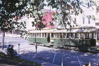 Ballarat Tramway Museum
Negative, Campbell Duncan, 1971
Yields information about tram operations and the area around City Loop in Sturt St.Colour positive (from a 35mm slide film) of No. 27 and 26 parked in the city loop, 1971 on a sunny day. Was from the end of a slide film strip and had a bit of the film holder remaining on the right hand edge. Has the parking meters on Sturt St in the photograph.trams, tramways, city loop, tram 26 tram 27 -
 Glenelg Shire Council Cultural Collection
Negative - Negative - KS Anderson Wharf Portland, Victoria, Zilah Maschmedt, 1961
Negative for a black and white photograph. Image shows a view for KS Anderson Wharf, from elevated position. Looking along pier to the Corkscrew. Wharf entrance in foreground transit shed. -
 Eltham District Historical Society Inc
Negative - Photograph, J.A. McDonald, Dixons Creek Road, c.May 1958
Dixons Creek Contractor MorrisRecord of various Shire of Eltham infrastructure works undertaken during the period of 1952-1962 involving bridge and road reconstruction projects, sometimes with Eltham Shire Council Project Reference numbers quoted. It was during this period that a number of significant improvements were made to roads and new bridges constructed within the shire that remain in place as of present day (2022). In many situations, the photos provide a tangible visible record of infrastructure that existed throughout the early days of the Shire. The album was put together by or under the direction of the Shire Engineer, J.A. McDonald.infrastructure, shire of eltham, 1958-05, bridge construction, dixons creek bridge, dixon's creek road -
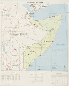 Beechworth RSL Sub-Branch
Map - Map Somalia Region, 1992
This map was used for briefing purpose only as the relief data is incomplete. Double sided coloured paper map of the Somalia Region with a 1:2 250 000 scale. Display side - PRODUCED AND PRINTED BY / 1 TOPO SVV SQN / ROYAL AUSTRALIAN SURVEY CORPS / DECEMBER 1992 DEF/ARMY 20463 / -
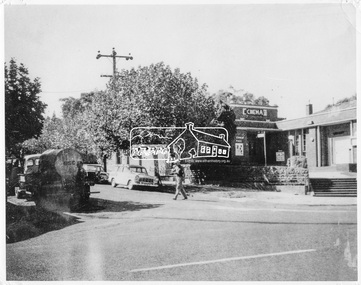 Eltham District Historical Society Inc
Negative - Photograph, Ian McDonald, Corner of Main Road and Arthur Street, Eltham, 4 Jan. 1968
The intersection of Arthur Street and Main Road Eltham, January 4, 1968. The Eltham Shire Council hall and offices on the right hand side. The Hall was also a cinema and operated as the Plaza Theatre from 1943 to about 1968. A truck with a water tank is on the left of the street, possibly cleaning the street. Note Cinema sign on hall. Copied from an original document produced by Ian McDonald (Eltham Shire Council) 1970. During the period 1969-1971 photos were being collected for a proposed publication on the history of the Shire of Eltham as part of its centenary celebrations in 1971 (managed by the Shire of Eltham Historical Society and Alan Marshall). The publication was Pioneers & Painters (1971), edited by Alan Marshall. The document titled "Shows area sold to Woolworths" consisted of a panorama of three B&W photo prints creating a panorama of the frontage along Main Road (SEPP_0744) and a single B&W photo print of the Shire of Eltham offices and Hall on the corner of Arthur Street and Main Road (SEPP_0737) along with typed and hand written notes by Ian McDonald. The panorama (SEPP_0744) was captioned in typewritten text "Old Shire Office and Hall, etc - Frontage of 285 feet along Main Road" and in pencil the date "4-1-68" The single image of the shire offices (SEPP_0737) was captioned in typewritten text "Main Road and Arthur Street Corner" In addition, the following handwritten notes in pencil: " I took these photos from the new fire station - the building in the middle is the old fire station - Moved to Research for the Scouts 1970" and signed "IMcD"This photo forms part of a collection of photographs gathered by the Shire of Eltham for their centenary project book,"Pioneers and Painters: 100 years of the Shire of Eltham" by Alan Marshall (1971). The collection of over 500 images is held in partnership between Eltham District Historical Society and Yarra Plenty Regional Library (Eltham Library) and is now formally known as 'The Shire of Eltham Pioneers Photograph Collection.' It is significant in being the first community sourced collection representing the places and people of the Shire's first one hundred years.Digital image 4 x 5 inch B&W Negsepp, shire of eltham pioneers photograph collection, eltham, arthur street, cinema, eltham hall, main road, shire hall, motion picture theartre, plaza theatre -
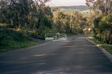 Eltham District Historical Society Inc
Negative - Photograph, Eltham Shire Council, Unidentified road, Eltham district, c.1985
One of a series of images on roll of film shot by Eltham Shire Council officers focussing on road and street infrastructure maintenance and upgrades and new rollover kerb and channel profilesRoll of 35mm colour negative film, 4 stripsKodak CP100 5094infrastructure, road construction, road drainage, road sealing, roadworks, shire of eltham, streets, streetscape -
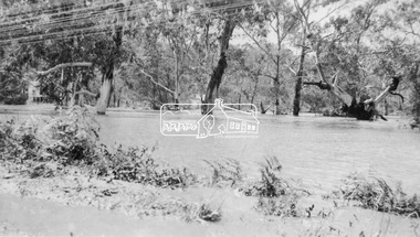 Eltham District Historical Society Inc
Negative - Photograph, Floodwaters, Diamond Creek, Eltham, 1934
The Diamond Creek in flood near the Main Road bridge at Eltham, Victoria. The Yarra also was in flood. In early December 1934 the "Greatest flood in the history of the Yarra" occured, according to The Argus newspaper. Bridges and houses were swept away with hundreds of people left homeless across the state. The historic 1934 flood of the Diamond Creek and Yarra River set the criteria for future planning with respect to flood water rise. Noted on reverse of print - Copied by Hugh Fisher, 82 Lygon St., BrunswickThis photo forms part of a collection of photographs gathered by the Shire of Eltham for their centenary project book,"Pioneers and Painters: 100 years of the Shire of Eltham" by Alan Marshall (1971). The collection of over 500 images is held in partnership between Eltham District Historical Society and Yarra Plenty Regional Library (Eltham Library) and is now formally known as the 'The Shire of Eltham Pioneers Photograph Collection.' It is significant in being the first community sourced collection representing the places and people of the Shire's first one hundred years.Digital image 4 x 5 inch B&W Neg (2 frames on one neg) Print 9 x 15.5 cmOn reverse of print - "Copied by Hugh Fisher, 82 Lygon St., Brunswick" (for Shire of Eltham)sepp, shire of eltham pioneers photograph collection, eltham, floods, 1934 flood, diamond creek (creek), floodwater -
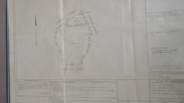 Peterborough History Group
Map - survey of Hamilton St wetland, Plan of Subdivision Hamilton Street
Subdivided to preserve the wetland, locals estimate it occurred between 1976 and 1983A3 plan of subdivision showing the outline of the swamp bounded by Hamilton St, Charles St and Cumming St. peterborough, survey map, golden pond -
 National Vietnam Veterans Museum (NVVM)
Map
Highly detailed map of Vietnam on parchment from Fwouc Tho Province. Map is waterproof.map, peter lewis -
 Eltham District Historical Society Inc
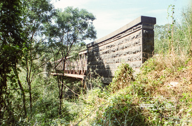
Negative - Photograph, Old Lower Plenty Bridge, c.Mar. 1983
Roll of 35mm colour negative film, 4 stripsKodak Safety 5035lower plenty bridge -
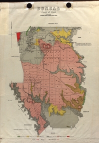 Federation University Historical Collection
Map - Plan, E.J. Dunn, Bungal County of Grant Parish Plan
E.J. Dunn was tje surveyor of this parish plan.Colour geological plan of Bungal in the County of Grant, Victoria. The areas circled in red ar craters.plan, bungal, bungeltap, black horse co. egerton, egerton, mount egerton, sister rose shaft, south learmonth co, kerrit bareet, bungaeeltap, yaloak, eastern moorabool river, corong, bungal station preemptive right, lal lal, western moorabool river, moorabool rover, borhoneychurck, mount egerton battery, bungal creek -
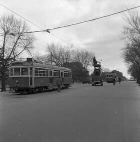 Ballarat Tramway Museum
Negative, Geoff Grant, 19/06/1955 12:00:00 AM
Negative No. N324 and black and white print made by a laser printer (stored in folder ) of W6 988 and W7 in Nicholson St. around the Albert St. intersection testing overhead. Two tower trucks in photo - assume to be No. 2 and 8. Negative scanned hi res and imaged updated 21/5/2020.trams, tramways, melbourne, nicholson st, testing overhead, commissioning, tram w6 988 tram w7 1003 -
Port Melbourne Historical & Preservation Society
Map - Melbourne and suburbs, MMBW, 8 Dec 1909
MMBW map of Melbourne and suburbs - Record plan up to July 1st 1913 (scale 3/4" = 1 mile)engineering - board of works, calder e oliver, russwaul(?) -
 Eltham District Historical Society Inc
Negative - Photograph, Cool Stores, Hurstbridge, 1917
View overlookng Hurstbridge with the Cool Stores complex in the middle of the view (opened in March 1915) surrounded by an orchard of fruit trees. Local orchardists housed their fruits in cold storage here before despatch by rail to domestic and international markets, sometimes out of season.This photo forms part of a collection of photographs gathered by the Shire of Eltham for their centenary project book, "Pioneers and Painters: 100 years of the Shire of Eltham" by Alan Marshall (1971). The collection of over 500 images is held in partnership between Eltham District Historical Society and Yarra Plenty Regional Library (Eltham Library) and is now formally known as 'The Shire of Eltham Pioneers Photograph Collection.' It is significant in being the first community sourced collection representing the places and people of the Shire's first one hundred years.Digital image 4 x 5 inch B&W Negshire of eltham pioneers photograph collection, hurstbridge, cool stores, orchards -
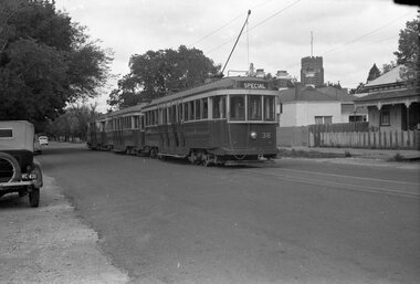 Ballarat Tramway Museum
Negative, Wal Jack, early 1950's
Yields information about three bogie trams possibly stored in Ripon St awaiting their use for an event.Negative and Digital images of the Wal Jack Ballarat Negative file of No. 36 and two other bogie trams parked in Ripon St North, just to the north of Sturt St. The house in the background is No. 3 Ripon St North and is still there (27-4-2020),. The spire of the St Peters Anglican Church can be seen. Tram is showing Special, possibly parked in Ripon St for a special event and waiting use. Perhaps for the Royal Visit. Photo may be related to Reg Item 7728.trams, tramways, ripon st, events, bogie trams, tram 36 -
Glenelg Shire Council Cultural Collection
Map - Fold-out Tourist Map of Portland and District, n.d
Black and white fold-out map of Portland District. reverse has maps of Portland and Mt. Gambier, plus tourist information about points of interest in both towns. When folded, photo of Cape Nelson lighthouse on front. -
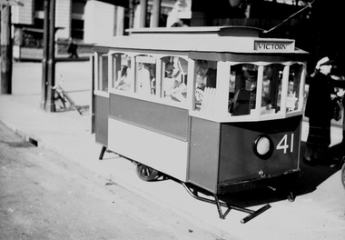 Ballarat Tramway Museum
Negative, Wal Jack, Jul. 1944
Yields information about Ballarat 's Treasure tram and fund raising during the second world war.Negative and Digital image of the Wal Jack Ballarat Negative file of the Treasure Tram built for fund raising by the depot staff to support the Most Popular Conductress Competition. See Reg Items 2129 and 5108 for more details. July 1944. Photographed at the corner of Sturt and Lydiard Streets. Image i1, original scan of the negative, image i2, and adjusted scan. trams, tramways, world war i, most popular conductress competition, conductresses, treasure tram, tram 41 -
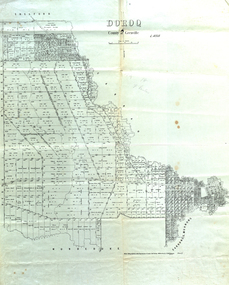 Federation University Historical Collection
Map, Doroq County of Grenville L4935, 1911, 28 June 1911
This plan is associated with former Ballarat School of Mines Student Richard Squire (1875-1876). Gift of the Squire FamilyParish Plan of Doroq in black ink printed on cream paper. It includes the township of Inverleigh and Barwon Rover. Some of the names on the plan are William McRobie, William MacRobie, Thomas Russell, W.C. Smith, John Bell, J. Moffatt, Thomas Moffatt, John Anderson, George Synnot, Charles Lloyd, William MacRobie, J. Flack, Alexander Campell, T. Maher, William Berthon. Thomas Jewell, James Carstairs, D. MCInnerney, F.H. Holland, Robert Morrison17 7/9 18 9 miles handwritten in pencil Photo lithographed at the Department of Lands and Survey Melbourne by T. E. McGauran 28.6.11 Price 1/-carrunge-murnong, murdeduke, carrah, shelford, inverleigh, barwon river, hesse, wingeel, george russell, george russell's pre-emptive section, john moffatt, w. c. smith, macrobie, john bell, thomas russell, t.f. mcgauran -
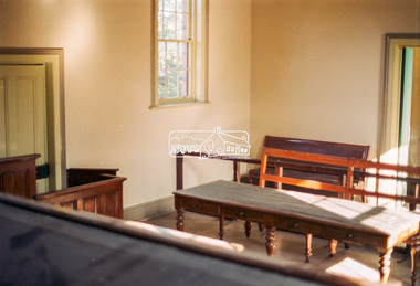 Eltham District Historical Society Inc
Negative - Photograph, Harry Gilham, Interior, Eltham Courthouse, 730 Main Road, Eltham, Sep 2004
eltham courthouse -
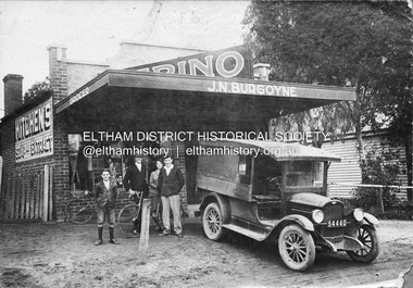 Eltham District Historical Society Inc
Negative - Photograph, J.N. Burgoyne’s store, Main Road, Eltham, Vic, c.1930
The photo is of John Neville and Ethel (Polly) Burgoyne’s store with eldest children and a 1927/28 model Chevrolet 1 ton truck. The store was located on Main Road just south of Bridge Street (present day No. 820 Main Road). L-R (unconfirmed): Francis (Frank) Neville Burgoyne (1916-2002), unidentified, Mary Frances Burgoyne (1914-1991) and John (Jack) William Burgoyne (1913-2005) which would date the picture as circa 1929/1930. Henry Charles Burgoyne (1920-1994) and Royston (Roy) Edward Burgoyne (1922-2004) not in picture. The unidentified male is believed to be an early boyfriend of Mary Frances at the time, not Reginald John Squire (1916-1981) whom she married in 1938 who was two years her junior. The new store was built in late 1925. At the same time Mr C. Nicholls’s new store was constructed. Both were considered modern shops, and an improvement on most, business establishments of the time. Mr. Nicholls’s store included alongside it a modern, weatherboard villa residence. Mr. Burgoyne’s store incorporated the post and telegraph office, which was operated by John Neville Burgoyne’s half-aunt, Miss Anne Hunniford. The unsealed footpath in front is reasonably extensive as not visible is a concrete kerb and channel which was laid from the Post Office to John Street during Nov-Dec 1926. Footpath construction in front of Burgoyne’s store commenced August 1942. An extension to the store was erected in 1939 for a new telephone exchange adjacent to the store and post office. A continuous telephone service operated by Mr Burgoyne and his family commenced operation 18 November 1939. Approximately 70 extensions were routed through the new exchange, 40 of which were transferred from the Greensborough Exchange. Reproduced on p92 of 'Pioneers & Painters' Cross Ref: 0702 shows extension on right of shopThis photo forms part of a collection of photographs gathered by the Shire of Eltham for their centenary project book,"Pioneers and Painters: 100 years of the Shire of Eltham" by Alan Marshall (1971). The collection of over 500 images is held in partnership between Eltham District Historical Society and Yarra Plenty Regional Library (Eltham Library) and is now formally known as the 'The Shire of Eltham Pioneers Photograph Collection.' It is significant in being the first community sourced collection representing the places and people of the Shire's first one hundred years.Digital image 4 x 5 inch B&W Negshire of eltham pioneers photograph collection, 1927 chevrolet series aa truck, burgoyne's shop, eltham, francis (frank) neville burgoyne (1916-2002), frank burgoyne, henry charles burgoyne (1920-1994), jack burgoyne, john (jack) william burgoyne (1913-2005), john neville burgoyne, main road, mary frances burgoyne squire (1914-1991), pioneers and painters, post office, shops -
 Kew Historical Society Inc
Map, MMBW, MMBW Plan No.67 Kew, 1900-1910
The Melbourne and Metropolitan Board of Works (MMBW) was established by an act of the Victorian Parliament in 1890 to prepare for and to implement a sewerage and water reticulation system across what was then inner Melbourne, its surrounding and middle distance suburbs, including Kew. The MMBW was disbanded in 1991.The map collection of the Kew Historical Society has at its core the historic maps assembled and originally stored in the City Engineer's Department of the City of Kew. These include maps in a number of scales. The vast majority of maps were produced by the MMBW in the first two decades of the twentieth century, and are solid working maps, backed by linen for durability. These maps are historically significant to Kew, the City of Boroondara and to the history of the development of state utilities in Victoria. A number of the Kew maps have additional details added by former municipal officers, including the levels reached by various floods. As these were working documents, information was added to them long after the period of their initial production and distribution.Early map of part of the Borough of Kew, created in the first decade of the twentieth century, at a scale 160 ft to 1 inch. The map covers what was then the north central part of Kew, bordered on its north by the Outer Circle Railway Spruzen and Beresford Avenues, in the west by Princess Street, in the south by High Street, and in the east by (about) Belford Road. The map shows the extent of urban development by that time, prominent institutions and the outlines of built structures in the municipality. Contour lines were added in ink to the map at a later stage.MELBOURNE AND METROPOLITAN BOARD OF WORKS / PLAN NO. 67 / KEW melbourne & metropolitan board of works, mmbw maps, mmbw plans, borough of kew, cartography -
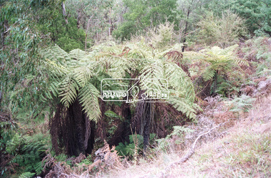 Eltham District Historical Society Inc
Negative - Photograph, Tree ferns beside Maroondah Aqueduct, Kangaroo Ground, 1991
Roll of 35mm colour negative film, 9 strips Colour prin 10 x 15 cmFuji HG 200 CA-1kangaroo ground, maroondah aqueduct -
Stawell Historical Society Inc
Map, 1971
Jallukar, County of Borungstawell -
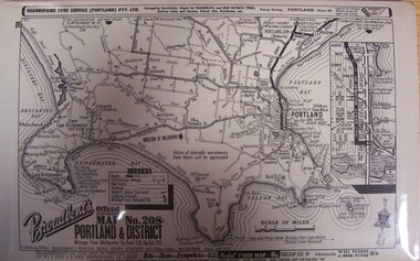 Glenelg Shire Council Cultural Collection
Map - Map - "Broadbent's Map of Portland and District, no. 28", n.d
Unknown