-
 Kew Historical Society Inc
Map, MMBW, MMBW Plan No.65 Kew & Heidelberg, 1900-1910
The Melbourne and Metropolitan Board of Works (MMBW) was established by an act of the Victorian Parliament in 1890 to prepare for and to implement a sewerage and water reticulation system across what was then inner Melbourne, its surrounding and middle distance suburbs, including Kew. The MMBW was disbanded in 1991.The map collection of the Kew Historical Society has at its core the historic maps assembled and originally stored in the City Engineer's Department of the City of Kew. These include maps in a number of scales. The vast majority of maps were produced by the MMBW in the first two decades of the twentieth century, and are solid working maps, backed by linen for durability. These maps are historically significant to Kew, the City of Boroondara and to the history of the development of state utilities in Victoria. A number of the Kew maps have additional details added by former municipal officers, including the levels reached by various floods. As these were working documents, information was added to them long after the period of their initial production and distribution.Early map of part of the Borough of Kew, created in the first decade of the twentieth century, at a scale 160 ft to 1 inch. The map covers what was then the south central part of Kew, bordered on its north by Malmsbury Street, in the west by Florence Avenue, in the south by Barkers Road, and in the east by Princess Street. The map shows the extent of urban development by that time, prominent institutions and the outlines of built structures in the municipality. Contour lines were added in ink to the map at a later stage.MELBOURNE AND METROPOLITAN BOARD OF WORKS / PLAN NO. 65 / KEW & HEIDELBERGmelbourne & metropolitan board of works, mmbw maps, mmbw plans, borough of kew, cartography -
 Stawell Historical Society Inc
Map
Shows Newington Co, Moonlight Co, St George Co, Victoria Co, Galatea Co Shows Tramline over Big Hill, Leviathan Co, Parish of Stawell, North Ward & Big Hill etcstawell -
Glenelg Shire Council Cultural Collection
Negative - Glass Plate Negative - Jackass Fern Gully, c. 1890
Stereographic glass plate negative. Image shows a group of people at Jackass Fern Gully. -
 Ballarat Tramway Museum
Negative, Geoff Grant, 7/05/1955 12:00:00 AM
Negative No. 297 and colour print made by colour laser printer (stored in folder ) of W5 723 inbound past the Camberwell Depot access tracks on route 74 on 7/5/1955. Photo by Geoff Grant. Negative scanned hi res and imaged updated 20/5/2020.trams, tramways, melbourne, camberwell depot, tram w5 723 -
 Eltham District Historical Society Inc
Negative - Photograph, J.A. McDonald, Building site inspection by Eltham Shire Council Building Surveyor, George Newton, c. July 1962
Record of various Shire of Eltham infrastructure works undertaken during the period of 1952-1962 involving bridge and road reconstruction projects, sometimes with Eltham Shire Council Project Reference numbers quoted. It was during this period that a number of significant improvements were made to roads and new bridges constructed within the shire that remain in place as of present day (2022). In many situations, the photos provide a tangible visible record of infrastructure that existed throughout the early days of the Shire. The album was put together by or under the direction of the Shire Engineer, J.A. McDonald.1962-07, building site, building surveyor, george e. newton, houses, eltham shire council -
 Greensborough Historical Society
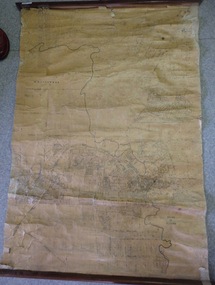
Map, Map of Greensborough - Jessop's Real Estate, 1930c
This map of Greensborough hung in the office of Cec Jessop's Real Estate office corner Main and Grimshaw Street. Includes a word document listing street name changes from the original map to today, according to Norm Colvin.This map was saved from the building when the business closed.Canvas roll-up map with timber rails top and bottom.greensborough - maps, cecil jessop, greensborough street names -
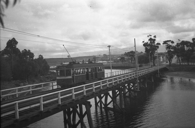 Melbourne Tram Museum
Negative, Wal Jack, 1943-44
Black and white negative, by Wal Jack, of W5 832, showing Special B, crossing the Maribyrnong River Bridge westbound with a number of passengers. The tram only bridge has been duplicated during September 1943. Photo not dated in the Wal Jack album, c1943 - 44trams, tramways, w5 class, special b, maribyrnong river bridge, maribyrnong rd, world war 2, tram 832 -
Glenelg Shire Council Cultural Collection
Negative - Negative - Portland Botanic Gardens, c. 1934
Negative for black and white photo. Portland Botanic Gardens. Footpath and arch. Photo also includes the Gardens Curators Cottagenegative, portland botanic gardens, curators cottage -
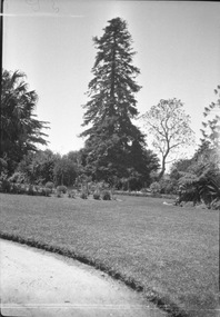 University of Melbourne, Burnley Campus Archives
Negative - Black and white negative, Garden View, 1922-1923
View across the lawn to the Californian Redwood and Jacaranda.lawns, californian redwood, jacaranda, j.l. provan, trees, garden view -
Whitehorse Historical Society Inc.
Map, Map of City of Nunawading, n.d
Hand drawn map of City of Nunawading showing heights above sea level.city of nunawading, maps -
 Marysville & District Historical Society
Map (Item) - Tourist and business map, Narbethong Community and Tourism Group, the Gateway TOURIST AND BUSINESS MAP, 08-2009
A tourist and business map of Narbethong, Buxton, and Taggerty. This map was produced by the Narbethong Community and Tourism Group Inc in August 2009. It was produced to promote the natural attractions, adventure activities, and food trail from the Black Spur, through Narbethong, Buxton, and Taggerty.A tourist and business map of Narbethong, Buxton and Taggerty.This publication has been produced by the Narbethong Community and Tourism Group Inc./ (NCTG) The information provided in this publication has been supplied by the individual/ members. NCTG takes no responsibility for its accuracy./ August 2009narbethong, buxton, taggerty, victoria, australia, tourist and business map, the gateway tourist and business map, black spur motel & caravan park, woodlands rainforest retreat, chestnut glade, black spur inn, wombat cottage, abbey lake luxury b&b spa cottages, camp narbethong, marapana farm stay b&b, mantirri b&b, little dene garden cottages, nareen cabins, silverstream b&b cottages, buxton hotel motel, south cathedral farm luxury b&b cottages, cathedral view b&b retreat, kingbilli country estate, cathedral valley farm, pinjarra gardens, willowbank at taggerty, sarsens rest, yarrolyn caravan park, danico design counted cross stitch, things of sand & stone, buxton zoo nursery, safetrek 4wd services, mystic mountains ski hire & outdoors, pnl 4wdriving, buxton trout and salmon farm, buxton bait and tackle, black spur roadhouse, tudor lodge service station roadhouse & ski hire, buxton roadhouse, buxton p.o. general store, igloo roadhouse, henry v111 manor house, buxton hotel, butters cafe, wagtail wines, little river wines, narby eggs, marapana agistment park, carmyle farm, hazelwood hazelnuts, cathedral view naturall therapies, cre8ing growth, linda hailey, naby cabinets, gb timber, narbethong timber & trading, rb automotive repairs, buxton car care, martyn slade building design, taggerty vet clinic -
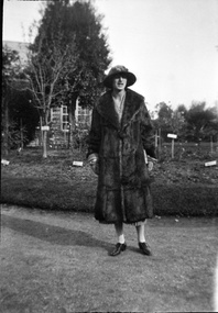 University of Melbourne, Burnley Campus Archives
Negative - Black and white negative, A Distinguished Guest?, 1922-1923
Woman wearing a splendid hat and full length fur coat standing on lawn at Burnley.women, hat, fur coat, lawn, burnley gardens, j.l. provan -
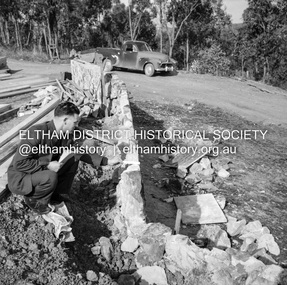
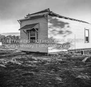 Eltham District Historical Society Inc
Negative - Photograph, J.A. McDonald, Inspection of storm damaged Abraham house at Kangaroo Ground, c. May 1962
Showing the effect of a wind storm that destroyed the house circa May 1962.. The Abraham family owned land near the Aqueduct and east of Nicholas Lane at Kangaroo Ground (based on photos, at or near 40 Nicholas Lane).Record of various Shire of Eltham infrastructure works undertaken during the period of 1952-1962 involving bridge and road reconstruction projects, sometimes with Eltham Shire Council Project Reference numbers quoted. It was during this period that a number of significant improvements were made to roads and new bridges constructed within the shire that remain in place as of present day (2022). In many situations, the photos provide a tangible visible record of infrastructure that existed throughout the early days of the Shire. The album was put together by or under the direction of the Shire Engineer, J.A. McDonald.1962-05, abraham house, kangaroo ground, nicholas lane, property damage, storm damage -
Whitehorse Historical Society Inc.
Map, City of Nunawading Street and Block Map
City of Nunawading Street and Block map.City of Nunawading Street and Block map. Scale: 1:10,000. with enlargement, Canterbury Road South to Burwood Highway.City of Nunawading Street and Block map. canterbury road nunawading, burwood highway burwood east, city of nunawading -
Whitehorse Historical Society Inc.
Map, Map of Mitcham, 1916?
Copy of early map of Mitcham.Copy of early map of Mitcham showing main roads and large blocks of land with owners' namesCopy of early map of Mitcham. mitcham road mitcham, heatherdale road mitcham, whitehorse road mitcham, morton, william, ainger, f, morgan, r. r., harding, w, sergeant, r, mcclelland, john, wilson, w, cook, j -
 Ballarat Tramway Museum
Negative, Geoff Grant, Feb. 1954
Negatives No. 270 and 271 and colour print made by colour laser printer (stored in folder ) of Melbourne PCC tram No. 980 decorated for the Royal Visit. Two negatives very similar. No. 271 slightly closer up by corners have light coming in. Envelope describes the negatives as "Especially decorated tram from Royal visit. It was the PCC tram done up. At Caulfield on the Darling Road, Pt Ormond Line. Feb. 23, 24, 25, 26 '54". 2 views side on". Photo by Geoff Grant. Negative scanned and image updated 19/5/2020.trams, tramways, pcc, point ormond, caulfield, darling road, tram 980 -
Whitehorse Historical Society Inc.
Map, Nunawading Road District, 01/04/1863
Plan of proposed new road - April 1863 & estimated expenses.Plan of proposed new road - April 1863 & estimated expenses. Scale 20 chains per inch. Proclaimed Roads 149.Plan of proposed new road - April 1863 & estimated expenses.nunawading road district, roads and streets -
Stawell Historical Society Inc
Map, 1959
Stawell, County of Borungstawell -
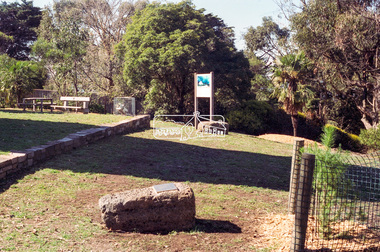 Eltham District Historical Society Inc
Negative - Photograph, Harry Gilham, Menin Gate Memorial Plaque and rock, Shire of Eltham Memorial Park, Kangaroo Ground, 1 Aug 2007
Memorial plaque created (2006) and mounted on a rock in conjunction with planting of a pine tree from the Lone Pine of Gallpoli. The Lone Pine (Descendant of the originbal tree from Gallipoli) Donated and planted by Betty Wickham 11/11/2005 In memory of those Shire of Eltham enlistees in the 1914-1918 war who lie in the cemeteries in Gallipoli Herberet Joseph Atkins (Queenstown) Frederick Carpenter (Queenstown) Geoffrey Treacher Grant (Eltham) Arthur George Hunt (Steels Creek) Alexander John McLeod (Yarra Glen) James Pryor (Eltham) Donald Robert Shillito (Yarra Glen) George Davidson Sommerville (Eltham) George Weir (Queenstown) John Valentine Wilson (Christmas Hills) Lest We Forgetshire of eltham memorial park, kangaroo ground, alexander john mcleod, arthur george hunt, christmas hills, donald robert shillito, eltham, frederick carpenter, geoffrey treacher grant, george davidson sommerville, george weir, herberet joseph atkins, james pryor, john valentine wilson, memorials, queenstown, steels creek, the lone pine, yarra glen -
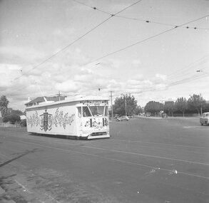
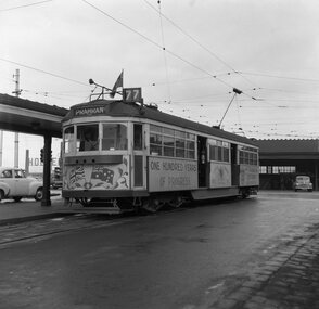 Ballarat Tramway Museum
Negative, Geoff Grant, 7/05/1955 12:00:00 AM
Negative No. 287 and colour print made by colour laser printer (stored in folder ) of SW6 961decorated for the centenary of the City of Prahran at Batman Avenue terminus on 7/5/1955. Photo by Geoff Grant. Showing destination of Prahran and route 77. Has three holes cut in the dash canopy lighting shield. Reference page 52 of Destination City 4th Edition. Hi res scan of negative and image updated 19/5/2020. See Destination City 4th Edition. page 52.trams, tramways, melbourne, batman ave, city of prahran, decorated trams, tram 961 -
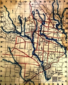 Melton City Libraries
Map, Mount Cottrell Fire group, Unknown
"In 1966, the Mount Cottrell Fire Brigades Group was formed as a way of consolidating the smaller groups around Melton, Rockbank, Toolern Vale, Sydenham, Truganina and Werribee. Its headquarters were established at the home of Ernest ‘Bon’ and Edna Barrie in Ferris Road, Melton. Captain Bon Barrie was a member of the Melton Fire Brigade and elected group and communications officer of the new Mount Cottrell Brigades Group". Fire Brigade Meeting 14th September held at Rockbank Formation a new Group in Region 14 Present: R/O H Rothsay, Assistant R/O R Orchard Tru? G Summerton Purpose of Group The pooling of the equipment in the area should be co-ordinated under one leader. The Brigade and private equipment should be co-ordinated under one leader. Formation was carried unanimously. To be called Mt Cotterill Group. Rockbank nominated Captain E W Barrie elected, Secretary K Watt Toolern Vale. Names listed C/O K L McNaughton Anakie Group COO/O R B Chirnside Lieut J Richmond Capt E Gillespie Toolern Vale Eddie L/ T S Atkin Stan L/T B Storey Bert Sec K Watt Keith Capt E W Barrie Melton Bon L/T K Gillespie Keith A Gillespie Arthur L/T G Lunson George L/T J Robinson Jeff Capt A Marquand Truganina Alan L/T I Cowie Ian Sec T Gard Tom Capt G Harrison Rockbank a/ps G Harrison N Harrison N Fisher a/ps S Hirt Melton Steve Pres M Chomley Sydenham Capt S Hughes Stan Capt L Waterson Werribee Lex Res/o J Hanson G/O S Cooper Bacchus Marsh Syd P/GO W Lidgett Wal Pro/O D Dunton G/O T Healy R C [Mt Macedon] Tom Reg Sec G Douglas Hand written notes of Edna Barrie Typed by Wendy Barrie Maps of the Mt Cottrell Fire groupemergency services, maps -
 Eltham District Historical Society Inc
Negative - Photograph, Warrandyte Bridge over River Yarra, c.1910
View of the 1875 timber trestle bridge over the Yarra River reproduced from a newsprint image. Also known as Anderson's Creek (Road) Bridge A contract was accepted for William Elliot to erect a bridge over the Yarra River at Warrandyte on Anderson's Creek Road and other improvements for £1,331.6.2 - Gazette No. 143. Tuesday, November 13th 1860 - http://gazette.slv.vic.gov.au/view.cgi?year=1860&class=general&page_num=2161&state=V&classNum=G143&id=). The bridge was washed away by floods in 1863. It was replaced with a taller timber trestle structure in October 1875, designed and built by C.S. Wingrove, Shire Clerk, Engineer and Surveyor for Eltham Shire Council. A replacement for this bridge was commenced in 1955 to cope with increasing traffic and this structure was widened in 2018 to meet further traffic demands. Argus (Melbourne, Vic. : 1848 - 1957), Thursday 23 September 1875, page 7 ________________________________________ THE WARRANDYTE BRIDGE. The ceremony of formally opening the newly erected bridge over the Yarra at Ander-son's Creek was performed on Monday last, in the presence of the members of the Eltham and Bulleen shire councils whose territories it joins, and a goodly number of the residents of the district. The task was delegated to Mr. Cameron, M.L.A., who, after a few introductory remarks declared the bridge to be opened, and christened it the " Warrandyte Bridge." The party then adjourned to Grant's Hotel, where a cold collation had been prepared. The chair was taken by the president of the Eltham shire (Mr. John Bell) and the vice chair by Mr. Kent, a member of the Bulleen council. Mr Robert Williamson proposed "Success to the bridge," coupling with it the name of Mr. Cameron, to whose exertions was in the main to be attributed the erection of that structure which was an ornament to the district and would prove of great service to both sides of the river. Mr. Cameron, in responding, alluded to the great difficulties, mainly of a pecuniary nature, that had been encountered in carrying out the project, and which had only been got over by their united efforts and by the liberal spirit in which the late Commissioner of Roads had dealt with the case. The healths of the contractor and the engineer were also drunk. The bridge is a trussed timber one, resting on yellow box piles sunk into the solid rock, each pier being weighted with 50 tons of stone. The abutments consist of dry stone walls, 6ft. thick at the base, and tapering to 3ft. on the top, the face of the work having a batter of 1 to 1. The length of the bridge is 308ft., there being four openings in the centre of 66ft. each, and two at the ends of 20ft. each. The width in the clear is 9½ft., and the height from the bed of the river about 33ft. The approaches comprise 1,100 cubic yards of earthwork, and the formation of 48 chains of sideling, the whole cost of the work, which was carried out under the direction of the engineer to the Eltham Shire Council, being £1,413.This photo forms part of a collection of photographs gathered by the Shire of Eltham for their centenary project book,"Pioneers and Painters: 100 years of the Shire of Eltham" by Alan Marshall (1971). The collection of over 500 images is held in partnership between Eltham District Historical Society and Yarra Plenty Regional Library (Eltham Library) and is now formally known as the 'The Shire of Eltham Pioneers Photograph Collection.' It is significant in being the first community sourced collection representing the places and people of the Shire's first one hundred years.Digital image 4 x 5 inch B&W Neg B&W Print 12.5 x 9 cmsepp, shire of eltham pioneers photograph collection, warrandyte, bridge -
Whitehorse Historical Society Inc.
Map, Springvale Road, c1970
Enlarged aerial photo of intersection of Springvale and Whitehorse Roads, Nunawading.Enlarged aerial photo of intersection of Springvale and Whitehorse Roads, Nunawading.Enlarged aerial photo of intersection of Springvale and Whitehorse Roads, Nunawading.springvale road, nunawading, whitehorse road, nunawading, maroondah highway, nunawading, aerial photographs -
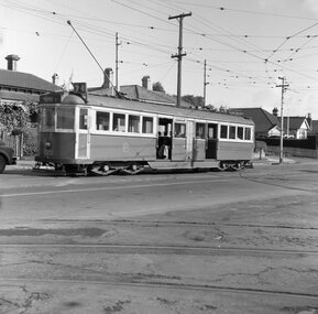
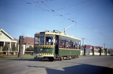 Ballarat Tramway Museum
Negative, Travis Jeffrey, 5/08/1962 12:00:00 AM
Colour Negative No. N410, of the Bendigo No 11 turning from McCrae St into Nolan St, with in the background. Tram has the destination of Lake Weeroona. Photo taken possibly on Sept or Oct 1962, given the tree pruning in the background - pruned back stumps. Colour laser printed copy of image stored in box 73. Original negative hires scan and image updated 28/5/2020.In red pen on folder that contained negative, "NR65A" and "23 Feb 1962" and inside "26 Sep 1962" and "6 Oct 1962". and "55A" in pencil. trams, tramways, bendigo, nolan st, lake weeroona, tram 11 -
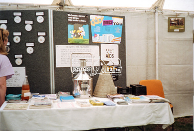 Eltham District Historical Society Inc
Negative - Photograph, Eltham Shire Council display, 1987 Eltham Community Festival, Alistair Knox Park, 7 Nov. 1987
Regular display by Council at the Eltham Festival providing ratepayers and visitors some insight into the daily operations of and services provided by Council and various equipment and machinery used.Roll of 35mm colour negative film, 4 stripsKodak GB 200 5096aids, community health, eltham festival, eltham shire council, infrastructure, shire of eltham, weights and measures, displays, alistair knox park -
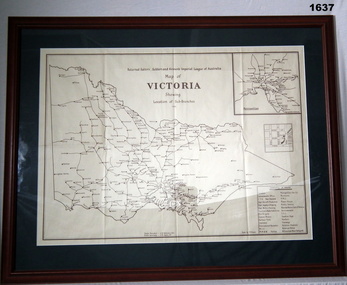 Bendigo Military Museum
Map - MAP, FRAMED, Bethany Gallery, 1949
Dark green mount with brown wooden frame. Brown printing on cream paper. Perspex covering map.Top centre of map: “Returned Sailors, Soldiers & Airmen's Imperial League of Australia Map of Victoria showing Sub Branches 1949” Stamped on rear: Bethany Gallery. Traditionally a touch of Excellence Terry ? Jarvis, 116 Bridge Street, Bendigo Vic 3550 Ph (03) 5442 4771brsl, smirsl, map rsl's -
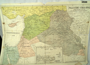 Bendigo Military Museum
Map - MAP MIDDLE EAST, Dyag Press Ltd
Coloured map of Palestine, Syria, Iraq & Crete, countries involved in the war.documents - maps, military history, middle east -
Whitehorse Historical Society Inc.
Map, Deakin, 1977
Map of the Commonwealth Electoral Division of Deakin. Scale 1: 25,000.Map of the Commonwealth Electoral Division of Deakin. Scale 1: 25,000.Map of the Commonwealth Electoral Division of Deakin. Scale 1: 25,000.electoral boundaries, deakin (commonwealth electoral division), australia. parliament -
 Mission to Seafarers Victoria
Map - Street Map, Port de Papeete Tahiti
Several items were given by a seafarer, Mr Nicholas Garlick (1926-2009) into the care of Father Brady who retired from St Pauls Cathedral, Melbourne in 2018. Father Brady later donated the collection of; objects, documents and an extensive collection of cruise ship menus (1937-end of 20thC) to the Mission via the intermediary William Hastie, volunteer at the Mission for Seafarers.Tourist map of the streets of Port de Papeete, Tahiti printed in greenish-grey ink on thin ochre coloured cardboard. Produced for Hertz rent a car (see media). port de papeete, tahiti, hertz, nick garlick, nicholas garlick, father brady, william hastie, ship engineer, sailors, seamen, seafarers -
 Eltham District Historical Society Inc
Negative - Photograph, J.A. McDonald, Unidentified quarry, Jan. 1961
Record of various Shire of Eltham infrastructure works undertaken during the period of 1952-1962 involving bridge and road reconstruction projects, sometimes with Eltham Shire Council Project Reference numbers quoted. It was during this period that a number of significant improvements were made to roads and new bridges constructed within the shire that remain in place as of present day (2022). In many situations, the photos provide a tangible visible record of infrastructure that existed throughout the early days of the Shire. The album was put together by or under the direction of the Shire Engineer, J.A. McDonald.1961-01, quarry