Showing 86650 items in the category Documentation with item type Photograph
-
 Malmsbury Historical Society
Photograph (Item), Mhs At Cemetery Working Bee C1995, Malmsbury c1995
Associated with - Mhs Buildings - Drive Way -
 St Kilda Historical Society
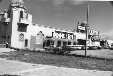
Photograph, The St Kilda Baths, c. 1970s
Old St Kilda Baths; daytime, shows nightclubs with signage affixed to frontage, cars parked immediately outside black and white photograph, original, unmounted, good conditionOld Sea Baths 100% -
 Southern Sherbrooke Historical Society Inc.
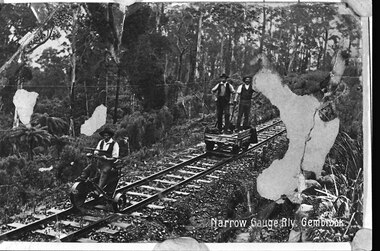
Photograph, Narrow gauge railway, Gembrook
B&W postcard sent to Jean Hermon's mother, Jane Beazley. It shows two men standing on a railway jigger and a third man in front of them, seated on a small three-wheeled vehicle on the track. All are dressed in hats, waistcoat, trousers and shirts. The railway line passes through thick bush. 'Narrow Gauge Rly. Gembrook' is printed at the bottom right corner. The original postcard has three patches where the surface is missing. -
 Marysville & District Historical Society
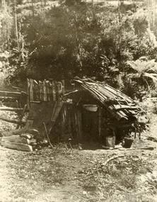
Photograph (item) - Black and white photograph, Unknown
An early black and white photograph of George Locke's hut in the Cumberland Valley near Marysville in Victoria.An early black and white photograph of George Locke's hut in the Cumberland Valley near Marysville in Victoria. George Locke was a well-educated young man and had some success prospecting in the Cumberland area before partnering with William Chester with whom he opened the Golden Bower gold mine in 1896. George and William then discovered a second reef which they named the Silver Bower mine. George lived in a log cabin in the Cumberland reserve and was known to be a loner. He was clever with his money and chose not to have a bank account in Marysville, where everyone would learn about his financial status. He banked at the ES&A in Fitzroy and at the time of his death in 1941 he had accumulated the princely sum of three hundred and sixty pounds. George Locke was known as "the Hermit of Cumberland Valley" and lived in his humpy until his last few days during which he moved into a Forest Commission's patrol hut because his old humpy had started to fall to pieces. When George passed away at the age of 81 years he had not visited Marysville for over 14 years. Today (2022) George Locke's hut is part of the Cumberland Reserve.george locke, cumberland valley, marysville, victoria, william chester, golden bower mine, silver bower mine, cumberland reserve, hermit of cumberland valley -
 Sunbury Family History and Heritage Society Inc.
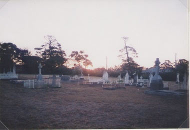
Photograph, Lydia Keyworth, Sunbury Cemetery, March 2001
The photograph of Sunbury Cemetery at sunset was entered into the Photograph Competition organised by the former Sunbury & District Heritage Association in March 2001.In 1862, land set aside in Cemetery Road for the Sunbury Cemetery was laid out in the following Christian denominational groups, Church of England, Roman Catholic, Baptist, Methodist, Presbyterian and Lutheran. Other non-denominational sites were set aside for paupers, heathens, Asians and pagans. Rebecca Jenkinson was the first person to be buried there in 1862. Over the years the size of the cemetery has expanded but it still occupies the original site off Shields Street in Sunbury and the names of the denominational divisions have changed over the years reflect a more inclusive outlook.Sunbury Cemetery replaced other smaller graveyards that were situated in some of the local church grounds and the earlier cemetery that was at The Gap township.A non-digital coloured photograph of a cemetery landscape with a number of old graves scattered across the open space. Some have small fences around them, while others simply display the headstones. There are trees in the background. sunbury cemetery, shields street, cemetery road, sunbury, cemeteries -
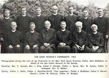 St Patrick's Old Collegians Association (SPOCA)
Photograph - Teachers, Jesuits
-
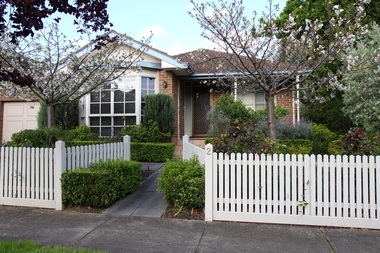 Surrey Hills Historical Society Collection
Photograph - 2 St Johns Avenue, Mont Albert, The Street Where You Live Project
Photos documenting this address as part of a photographic series undertaken by volunteer photographers during 2013 and 2014 for The Street Where You Live Project. This was organised through the Surrey Hills Neighbourhood Centre and covered the postcode 3127 in the cities of Boroondara and Whitehorse.These photos provide a snapshot of real estate in the suburbs of Mont Albert and Surrey Hills during a period of rapid change with many properties on large blocks demolished to create higher density residential development or renewal of single dwellings. At particular risk were properties not covered by heritage overlays, especially interwar housing and post 1950's housing. -
Stawell Historical Society Inc
Photograph, Interior Allanvale Great Western. Photographic Committee National Trust Photographs of Stawell
7006 National Trust Photographs Interior Allanvale Great WesternSeries of Colour Photographs of buildings of interest to National TrustJune 1993buildings, heritage buildings -
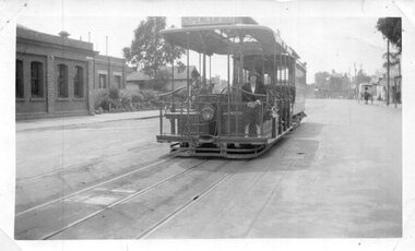 Melbourne Tram Museum
Photograph - Set of 4 Black & White Photograph/s, Don Schulz, mid 1920's
Series of four Black and White Photographs cable trams in Melbourne at the Bridge Road terminus or city during the mid 1920's/ .1 - Bridge road terminus with the car house or depot on the left hand side with the destination of Spencer St. .2 - Gripman possibly checking his watch with a depot worker? stepping off the tram. .3 - family stepping off the tram with cable trailer 368 in the view - Elizabeth St, near Flinders St? See Brian Weedon's notes re the photo and the trailer. .4 - As for .1 - with an X marked above the lady and a very large motor car passing. Printed on Kodak Paper. Adam Chandler advised by email 5/8/2020: " note there's a destination box fitted to the grip - from memory, these started to be used from the mid-1920s with the dummy and trailer repaints into the brown colour? That also looks to be either a 1925 or 26 Buick - the "moustache" shape at the top of the front radiator grille and the distinctly angled lower sash of the windscreen are further hints. Given the Richmond line closed in 1927 for conversion I'd say some time between 1924 and 29 June 1927." Also see image i5.pdf for further notes regarding the photographs and the Bridge Road tram depot building - use the original pdf file to read. Image i6, has had the "X" removed - done by Darren Hutchesson.On rear in ink in each print, "Cable car Melbourne" and "286 Anzac Hy/Marion Rd Adelaide SA, collection of late Don Schultz"trams, tramways, cable trams, bridge road, flinders st, richmond depot, hawthorn bridge, tram 368 -
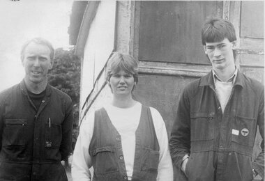 Ballarat Tramway Museum
Photograph - Working on horse tram No. 1, 13/12/1985
791.1 - From left to Right - Dave Macartney, Jacqui Edwards and Gary Wood standing in front of the horse tram. Photo by Paul McDonald 791.2 - Jacqui Edwards scraping back old paintwork to reveal car lining details. 791.3 - As above, but with niece, Kelly Edwards (age 12) 791.1 - see page 5 of Feb. 1993 issue of Trolley Wire, shows tram on trailer before being unloaded. See Reg Item 7401 for tracings made after scraping back the paintwork.Has a close association with those involved in the reconstruction of horse tram No. 1Set of three prints of Ballarat Tramway Museum personnel involved in the reconstruction of the horse tram during early 1986.trams, tramways, btps personnel, horse trams, reconstruction, btps , tram 1 -
Glenelg Shire Council Cultural Collection
Photograph - Photograph - Blacknose Quarry, 1952
Port of Portland Authority ArchivesFront: Front- Blacknose Quarry face 29/8/52 Bulldozer spreading overburden from top of Blacknose quarry, at foot of cliff face.- Printed in bottom frame. Back- Purple PHT stampport of portland archives, blacknose quarry, bulldozer -
Glenelg Shire Council Cultural Collection
Photograph - Photograph - aerial view of railway line between Heywood and Rennick, 03/05/1952
From a series of photographs taken for Victorian Railways in 1952.Back: 'Heywood - Rennick 21394 - 19665 261m 42c ' - all black ink. Purple VR aerial survey stamp. '3 May 1952' - black stampvictorian railways, heywood, rennick, aerial photography -
 Bialik College
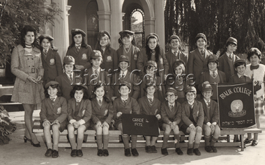
Photograph (item) - Grade 4, 1972, 1972
Grade 4, 1972. Please contact [email protected] to request access to this record.class photograph, 1970s -
 Lakes Entrance Historical Society
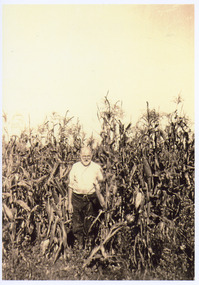
Photograph - Falk Family, 1925 c
Sepia toned photograph of Frederick Louis Falk standing in a tall crop of maize at Kalimna West Victoriagenealogy, agriculture -
 Surrey Hills Historical Society Collection
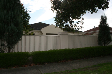
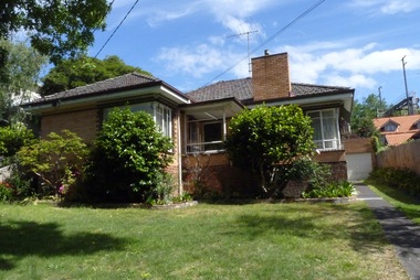
Photograph - 5 Tyndall Street, Surrey Hills, The Street Where You Live Project
Photos documenting this address as part of a photographic series undertaken by volunteer photographers during 2013 and 2014 for The Street Where You Live Project. This was organised through the Surrey Hills Neighbourhood Centre and covered the postcode 3127 in the cities of Boroondara and Whitehorse.These photos provide a snapshot of real estate in the suburbs of Mont Albert and Surrey Hills during a period of rapid change with many properties on large blocks demolished to create higher density residential development or renewal of single dwellings. At particular risk were properties not covered by heritage overlays, especially interwar housing and post 1950's housing. -
Glenelg Shire Council Cultural Collection
Photograph - Photograph - grain silo construction, 1964
Port of Portland Authority archivesFront: (no inscriptions) Back: P.H.T./ Print No. ... Neg. No 80/ Date taken 9-9-64/ SUBJECT. (Ink stamp with blue pen and pencil additions, centre)port of portland archives, grain silos -
 Ringwood and District Historical Society
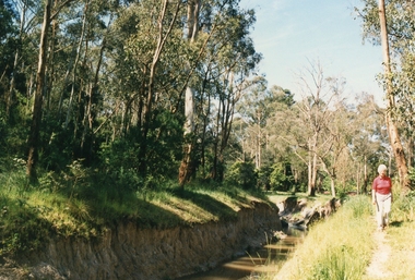
Photograph, Mullum Mullum Creek on 29th Oct 1989, south bank near end of Margaret Street, 1989
Digital photograph -
 Melbourne Tram Museum
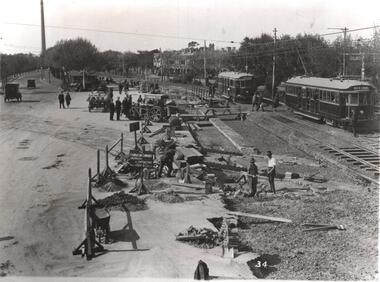
Photograph - Black & White Photograph/s, Melbourne & Metropolitan Tramways Board (MMTB), Jan. 1926
Black and white photograph of the conversion of the intersection of Domain Road, St Kilda Road, Domain Junction from cable tram to electric tram. Shows the Toorak Road Tram remaining trackwork, the temporary track for the electric trams with 276 inbound with the destination of North Coburg and another W class tram outbound to St Kilda Beach. Note the temporary platform and the temporary board crossing. Has "The Foundation Company Engineers and Contractors" sign in the view and the petrol? powered roller. Photo from the Collection of the Department of Infrastructure now with the Public Records Office - image number H101. Note: this photo is now out of copyright and was not an original VR photograph, but one copied from another source and collected as their Heritage series.Has Department of Infrastructure copy right stamp on rear and number "H513" in ink on rear and "2-5".trams, tramways, swanston st, cable trams, trackwork, new tramway, flinders st, conversion -
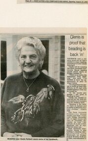 Park Orchards Community House
Photograph, Beading course at Park Orchards Community House, with tutor Gladys Rohrlach. Doncaster-Templestowe News 16 August 1988
Unknown year -
 City of Moorabbin Historical Society (Operating the Box Cottage Museum)
Photograph - Map of Dendy's Special Survey, 1852 Map of Henry Dendy's Special Survey of 1841, 19th Century
A Map drawn in 1852 that shows the 5,120 acres that formed Dendy's Special Survey of 1841. In 1840 Henry Dendy, a farmer in Surrey, England acquired a "Special Survey" from the Commissioners for Land and Emigration which gave Dendy the right to choose land in Port Phillip for the "bargain basement" price of only £1 per acre for 5120 acres, (an area of 8 square miles). The Special Survey also included the right to "the shipment of a worker for every £20 spent on land, whose free passage was paid by the Crown, equalling a total of 100 workers ". Accordingly Dendy sold his English holdings and paid the required £5120 and arrived in Melbourne in February 1841. However by this time land in the new colony was selling for £5 - £40 per acre. Because Henry Dendy possessed the order from the Colonial Office in London he was able to successfully oppose Governor LaTrobe's attempts to alter the price of the land. Dendy appointed Jonathan Were, (an entrepreneur, who had arrived in 1839), as his Manager and who later became a partner. Together, Dendy and Were decided on an area 5 miles south from Melbourne, bounded by North Road, East Boundary Road, South Road and to the west by Port Phillip Bay. Were and Dendy pitched their tents in the area now known as ' Park St, Brighton' and sank a well near the corner of 'St Andrew's St and Wells St'. By 1845 J.B Were and Company had bought almost half of Dendy's land and Were built himself "Moorabbin House" in Were St Brighton made from stone, quarried from local cliffs. It was still standing in 1924. Legend records Moorabbin is named after the Aboriginal word for ' Mother's Milk ' The soil is very fertile and well supplied with water especially in the area called 'East Brighton' - now known as Bentleigh and East Bentleigh - By 1850 the area had developed with numerous market gardens, dairy farms, fruit gardens and vineyards supplying food for the growing population of Melbourne.This Map shows the birth of the Brighton and Moorabbin area. On 18th January1859 Brighton was proclaimed a Municipality and a Borough by October 1863. Meanwhile, following a Petition, the area of East and South Brighton, incorporating Mordialloc, Cheltenham, Mentone, Sandringham and Oakleigh separated from Brighton to form the Moorabbin District Roads Board becoming the first Local Government Authority. Col. William Mair was elected as the first Chairman of the Moorabbin Roads Board. Moorabbin Shire 1871 developed further and was declared a City in1934. The City of Moorabbin was the largest Municipality in Melbourne before the Amalgamation of Councils in 1994 when it was divided in the south to City of Kingston and in the north to City of Glen Eira A Photo-lithographed 1852 Map showing the 5,120 acres that formed Dendy's Special Survey of 1841. Henry Dendy & Jonathan Were chose an area 5 miles south from Melbourne, bounded by North Road, East Boundary Road, South Road and to the west by Port Phillip Bay. Moorabbin County of Bourke / Photo-Lithographed at the department of Lands and Survey. /Melbourne. / Price 1/- brighton, moorabbin, bentleigh, cheltenham, dendy henry, bent thomas, were jonathan, special survey -
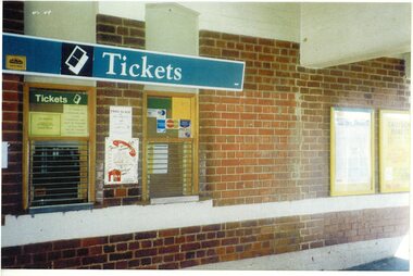 Ringwood and District Historical Society
Photograph, Ringwood Railway Station before development- circa 2000
Coloured photograph"Written on back of photograph" Ringwood station before development. Ticket Office -
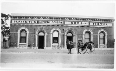 Stawell Historical Society Inc
Photograph, Slattery's Bricklayers Arms Hotel in Barnes Street Stawell
Bricklayers Arms Hotel Barnes Street Stawell Hotel with horse and cart out front plus bicycles leaning against buildingstawell -
 Lakes Entrance Historical Society
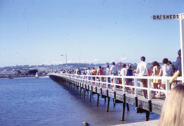
Photograph - Footbridge, Nelson Joan, 1985c
Colored photograph of a crowd of people in summer clothing returning to the town across the footbridge. Yacht and small boat on northern shore, delicatessen on corner of Myer St and Esplanade in view. Lakes Entrance Victoriabridges, waterways, tourism -
 Melbourne Legacy
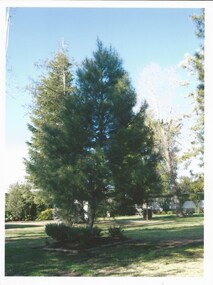
Photograph - Photo, tree planting, Legacy Lone Pines, 2008
A letter from Mrs Alwyn Drysdale on behalf of her husband Bob, to accompany photos of pine trees planted by him over time in various towns and schools. The trees had been organised by Legacy as part of their Lone Pine programme and he wanted to provide an update of their growth. Since the early 1970s Legacy had a commemorative programme of providing trees grown from seeds from Gallipoli to various towns throughout Australia. See the Lone Pine brochure at 00593. These trees were planted in the early 2000s. Melbourne Legacy's Commemoration Committee was responsible for the collection, propagation and dedication of Lone Pines from the 24th Battalion tree at the Shrine of Remembrance. On the 14th September 1989 further seedlings were collected with the hope to raise 1,000 trees from the seeds. Thus, Legacy is helping to keep the memory of the Gallipoli "Lone Pine" alive - its spirit living on today. Presentations are made to schools, ex-service organisations and interested bodies by Legacy Clubs in the hope that they will be cherished as a symbol of nationhood and of its just pride, devotion, courage, selflessness and sense of service to others.A record of tree planting of Lone Pine trees and their progress.Colour photo x 10 of pine trees and a letter.00746.1 Letter to Carmel at Legacy from Mrs Alwyn Drysdale of Kyabram. 00746.2 Kyabram Secondary College. Planted 10/9/1998. 00746.3 St Augustine's College, Kyabram. Planted 11/11/1998 00746.4 Girgarre Primary School. Planted 11/11/1999 00746.5 Tongala Aged Care Hostel. Planted 25.4.2000 00746.6 Merrigum Primary School. Planted 1.9.2000 00746.7 Kyabram and District Memorial Hospital. Planted 19/1/2001 00746.8 Tongala Primary School "Lone Pine" planted 2/9/2003, taken 31/7/2008 00746.9 "Warramunda" Village for Aged. Planted 13/9/2003 00746.10 St. Pat's College Tongala. Planted 11/11/2004 00746.11 Stanhope Primary School. Lone Pine planted 15/8/2005, taken 27/7/2008 tree planting, lone pine -
 Old Colonists' Association of Ballarat Inc.
Photograph, Clare Gervasoni, 5 Charles Anderson Grove, Lake Gardens
charles anderson grove, old colonists association of ballarat, retirement village, 5 charles anderson grove -
Stawell Historical Society Inc
Photograph, Mr Will J. Rees's water colour painting called "Near The End Of Spring" 1900
Will J. Rees Water colour painting 1900stawell -
 Surrey Hills Historical Society Collection
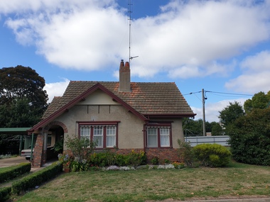
Photograph - 50 Zetland Road, Surrey Hills, The Street Where You Live Project
Photos documenting this address as part of a photographic series undertaken by volunteer photographers during 2013 and 2014 for The Street Where You Live Project. This was organised through the Surrey Hills Neighbourhood Centre and covered the postcode 3127 in the cities of Boroondara and Whitehorse.These photos provide a snapshot of real estate in the suburbs of Mont Albert and Surrey Hills during a period of rapid change with many properties on large blocks demolished to create higher density residential development or renewal of single dwellings. At particular risk were properties not covered by heritage overlays, especially interwar housing and post 1950's housing. -
 Ringwood RSL Sub-Branch
Photograph, 2 naval ships
Photograph -
 St Patrick's Old Collegians Association (SPOCA)
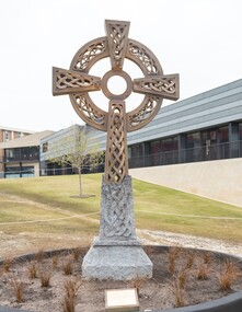
Photograph - History, Celtic Cross
-
 Creswick Campus Historical Collection - University of Melbourne
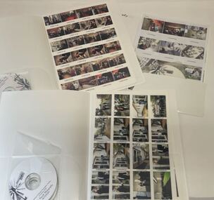
Photograph - Professional photographs from 2007 to 2010 for the School of Forest and Ecosystem Sciences, Neil Newitt
Seven A4 folders of proof sheets and CD ROM files of professional photographs from 2007 to 2010 for the School of Forest and Ecosystem Sciences. Includes the 2010 centenary dinner.