Showing 89456 items in the category Documentation with item type Photograph
-
 Lakes Entrance Historical Society
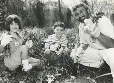
Photograph, B Advertiser, Weed Worriors, East Gippsland Victoria, 1990 c
Black and white photograph of Don Burke with Weed Worriors seven year old Zephyr Pavey and Maisie Dubosersky removing invasive seedlings from bushland East Gippsland Victoriaeducation, environment, land reclamation -
 Ballarat Tramway Museum
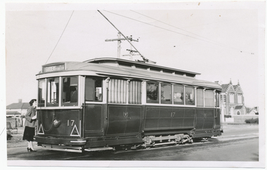
Photograph - Black & White Photograph/s, Digital Image, Wal Jack, 27/06/1957 12:00:00 AM
Yields information about Ballarat Trams and streetscapes early 1960's and the details of the Victoria St terminus, Yields information about Ballarat Trams and streetscapes early 1960's and the details of the Victoria St terminusBlack and white print of Ballarat 17, in Victoria Street, at Otway St photographed by Wal Jack, 27/6/1957. Two copies. A lady is standing at the back of the tram, possibly talking to the conductor. Tram has the destination of Gardens via Sturt St West. Has the Convent building in background. Photo print courtesy of Port Dock Railway Museum, now the National Railway Museum. See worksheet 4311 for letter and details of prints sent to Bill Scott, 19/10/2001. Any photo credit to mention NRM Collection. 4412.1 - Digital image from the Wal Jack Ballarat Album of the same photograph. See i3 for details of the rear of the photograph.On rear of copy 1 "SEC Ballarat / 17 / Victoria / 27/6/57 / Wal Jack" Copy 2 "DAC" in ink, bottom right hand corner. 4412.1 - on rear of photo in ink, "SEC Ballarat, No. 17 Victoria St at Otway St, Ballarat East 25 June '57" and "W. Jack photo Neg. to D. Colquhoun"trams, tramways, victoria st, tram 17 -
 Stawell Historical Society Inc
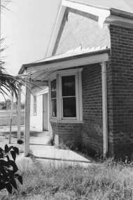
Photograph, Wehl Family home "Carlsruhe" on the Western Highway
Front Corner of Living Room and bay Windows Private Home "Carlsruhe" Western Highway (Wehl) Family Demolished 1993stawell -
 Bendigo Historical Society Inc.
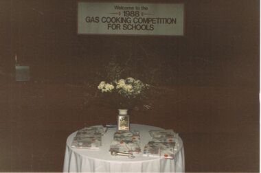
Photograph - CASTLEMAINE GAS COMPANY COLLECTION: PHOTO TABLE, 1988
Photo of a table with several packages and a vase of white flowers. The sign ''Welcome to the 1988 Gas Cooking Competition for Schools'' above the tableKodakevent, entertainment, school's cooking competition -
 Marysville & District Historical Society
Photograph (Item) - Colour photograph, Travel Victoria, 2006
A colour photograph of Murchison Street in Marysville in Victoria.A colour photograph of Murchison Street in Marysville in Victoria.murchison street, marysville, victoria, photograph -
 Glenelg Shire Council Cultural Collection
Photograph - Photograph - Portland Rifle Club, n.d
Black and white photo. Group of men sittings and standing on wooden sleeper outdoors. Most of them are holding firearms. Members of shooting club.sporting, recreation, sport, hunting -
 Surrey Hills Historical Society Collection
Photograph - 3 Como Avenue, Surrey Hills, The Street Where You Live Project
Photos documenting this address as part of a photographic series undertaken by volunteer photographers during 2013 and 2014 for The Street Where You Live Project. This was organised through the Surrey Hills Neighbourhood Centre and covered the postcode 3127 in the cities of Boroondara and Whitehorse.These photos provide a snapshot of real estate in the suburbs of Mont Albert and Surrey Hills during a period of rapid change with many properties on large blocks demolished to create higher density residential development or renewal of single dwellings. At particular risk were properties not covered by heritage overlays, especially interwar housing and post 1950's housing. -
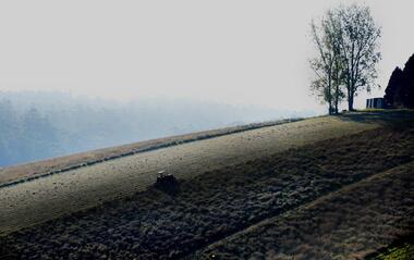 Southern Sherbrooke Historical Society Inc.
Photograph - Photo, Cotswold Valley
Colour photograph of a farm in the Cotswold Valley, Menzies Creek, possibly Bob Endersby's land. Photo shows a field in morning mist. A tractor is ploughing the fields. There are trees and tanks on the right side, and many trees in the misty background. Sourced from Facebook, 2019. Photographer unknown. -
 Ringwood and District Historical Society
Photograph, Looking north down Werac Drive, North Ringwood with lake headwater's site behind light standard on left in February 1979
B552 N19 Part of a 51-photo record of the development of the "Kubis" Estate, Ringwood North, including road works to Debbie Place, Kubis Drive, Werac Drive, Manuelo Drive, Iluka Place and Glenvale Road. From the Jack Lundy Clarke collection. -
Port Melbourne Historical & Preservation Society
Photograph - Starch factory', 1994
Donor had this print made for display purposes, from a neg belonging to the PMCC Engineering staff; one of a series shot by a staff member from vantage points relating to 19th C photos belonging to the city (in this case, beside the Lagoon)Colour photo of 'starch factory' (former Harper's factory) from corner West Esplanade and Beach Street late 1980s/early 1990s- building as shell only, waiting redevelopmentbuilt environment - industrial -
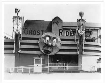 St Kilda Historical Society
Photograph, Ghost Ride Luna Park, c. 1934
Amateur photograph, entrance to the Ghost Ride entrance, Luna Park, St Kildablack and white photograph, unmounted, a small and a large copy, good conditionNEG 19 -
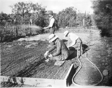 University of Melbourne, Burnley Campus Archives
Photograph - Black and white print, Putting Out Seedlings, Unknown
Note by T.H. Kneen 11 December 1991, "Gentleman holding hose is George Russ (1916-36), who was the staff member responsible for the management of the grounds and practical training of students. Position of espaliers is puzzling-are the beds being planted up the future creation of the bush house?"Black and white print. 2 female students sitting on a board planting and a man standing watering with a hose. On reverse, "Title: Putting out Seedlings Neg:176."female students, planting, seedlings, george russ, students, espaliers, students working outside, bush house, shade house -
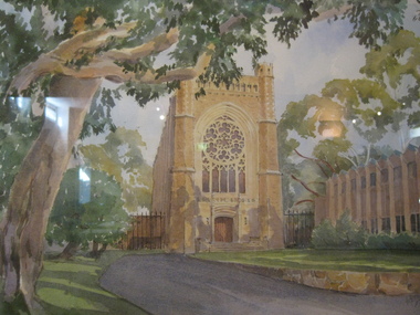 St Patrick's Old Collegians Association (SPOCA)
Photograph - Buildings, Newman, Artwork, Chapel
-
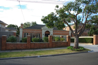
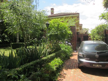
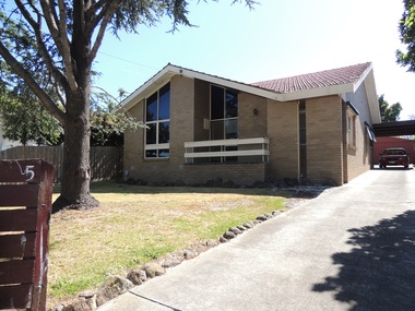 Surrey Hills Historical Society Collection
Photograph - 5 Inglisby Road, Mont Albert, The Street Where You Live Project
Photos documenting this address as part of a photographic series undertaken by volunteer photographers during 2013 and 2014 for The Street Where You Live Project. This was organised through the Surrey Hills Neighbourhood Centre and covered the postcode 3127 in the cities of Boroondara and Whitehorse.These photos provide a snapshot of real estate in the suburbs of Mont Albert and Surrey Hills during a period of rapid change with many properties on large blocks demolished to create higher density residential development or renewal of single dwellings. At particular risk were properties not covered by heritage overlays, especially interwar housing and post 1950's housing. -
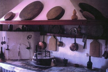 Ithacan Historical Society
Photograph, Traditional Ithacan kitchen
Pictured is the open fire used for cooking that would have been found in a traditional Ithacan home. Whilst most now use electric and portable gas appliances, these open cooking areas can still be found in the kitchens of many of the old homes on the island. The mortar and pestle and baking dishes pictured are sill used today in the preparation of traditional dishes.Cooking and food is an intrinsic part of Ithacan culture and plays an important role in maintaining identity and traditions for the Melbourne's Ithacan community. Recipes and particular cooking techniques are passed on from generation to generation. A coloured photograph of the typical kitchen copper pans and cooking utensils used in a traditional Ithacan kitchen. -
Malmsbury Historical Society
Photograph (Item), Memorabilia Display At Town Hall, Malmsbury ca1989
Buildings - Town Hall People - "Slimmon, Bill & Bruce; Bates, Alf" -
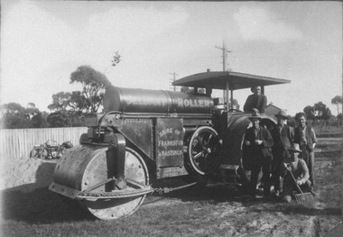 City of Ballarat Libraries
Photograph, Jelbart Road Roller circa 1930s
Jelbart Road Roller property of Shire of Frankston and Hastings circa 1930. This roller was manufactured in Ballarat by Jelbarts, whose foundry was located in Mair Street. jelbart, road roller, mair street, manufacturing, foundry, frankston, hasting, ballarat -
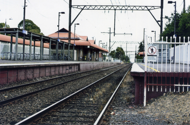 Whitehorse Historical Society Inc.
Photograph, Mitcham Railway Station
Coloured photograph of Mitcham Railway Station southern platform looking west towards the city -2012mitcham railway station, railways -
 Ringwood and District Historical Society
Photograph - Group, Ringwood Technical School 1964 Form 2D, c 1964
Black and White Photographrts, ringwood tech -
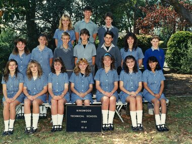 Ringwood and District Historical Society
Photograph - Group, Ringwood Technical School 1989 Year 10.6, c 1989
Colour Photographrts, ringwood tech -
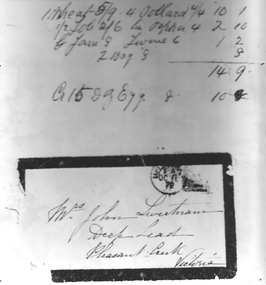 Stawell Historical Society Inc
Photograph - Realia, McMullin -- Docket, Sweetman envelope
McMullin. Docket. Envelope to Mrs SweetmanDocket Sept. 22 1903 to Mr J.R. Morgan for 8 items: Total Price 2 L. 16 S. 1D. also photo of black bordered envelope to Mrs John Sweetman with post mark and stampEnvelope: Mrs. John Sweetman, Deep Lead, Pleasant Creek, Victoria. Post Mark Mel S.A. OC 11 72 1 Wheat = 5/9; 4 Pollard 10/1: 1/2 Job =2/6 ; Pepper= 4/2/10; Jam= 8; Liver 6 1/2: 2 bags= 8; Sub total =14/8 150z eggs = 10 stawell -
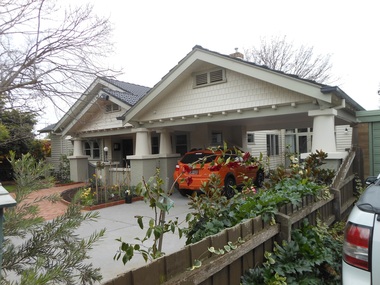 Surrey Hills Historical Society Collection
Photograph - 26 Langford Street, Surrey Hills, The Street Where You Live Project
Photos documenting this address as part of a photographic series undertaken by volunteer photographers during 2013 and 2014 for The Street Where You Live Project. This was organised through the Surrey Hills Neighbourhood Centre and covered the postcode 3127 in the cities of Boroondara and Whitehorse.These photos provide a snapshot of real estate in the suburbs of Mont Albert and Surrey Hills during a period of rapid change with many properties on large blocks demolished to create higher density residential development or renewal of single dwellings. At particular risk were properties not covered by heritage overlays, especially interwar housing and post 1950's housing. -
University of Melbourne, Burnley Campus Archives
Photograph - Colour prints, Demolition Around Tennis Court and Nursery, 1990
11 photographs of views near the tennis court and nursery. Not scanned.tennis court, nursery, demolition, science laboratories -
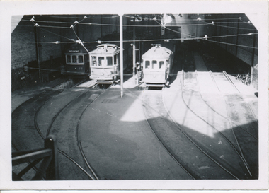 Ballarat Tramway Museum
Photograph - Black & White Photograph/s, Wal Jack, 24/06/1949 12:00:00 AM
Black and White print contained within the Wal Jack Bendigo and Geelong Album, see Reg Item 5003 for more details. Photo of Geelong Nos 36, 3 and 31 at the depot building entrance, or inside depot, 24-6-1949. Photo by Wal Jack from the Roster Room landing. Shows the depot track arrangements. See Also Reg item 5891 for a ground level photograph. i1 - scan of print in the album i2 - rear of image i3 - scan of negative at 3200dpi added 18/6/2020. On rear in ink SEC Geelong / Nos. 36, 3, 31 inside depot from Roster Room landing / 24-6-1949". Has the Wal Jack copyright stamp in the top right hand corner with the number T296 written in.trams, tramways, geelong, depot, tram 36, tram 3, tram 31 -
National Vietnam Veterans Museum (NVVM)
Photograph, Photograph of medical personnel
Contains various photos of RAAMC (Royal Australian Army Medical Corps) in Vung Tau in 1971 & medical personnel off duty shots in sleeping quarters.raamc, royal australian army medical corps., vung tau -
 Surrey Hills Historical Society Collection
Photograph - 53A Essex Road, Surrey Hills, The Street Where You Live Project
Photos documenting this address as part of a photographic series undertaken by volunteer photographers during 2013 and 2014 for The Street Where You Live Project. This was organised through the Surrey Hills Neighbourhood Centre and covered the postcode 3127 in the cities of Boroondara and Whitehorse.These photos provide a snapshot of real estate in the suburbs of Mont Albert and Surrey Hills during a period of rapid change with many properties on large blocks demolished to create higher density residential development or renewal of single dwellings. At particular risk were properties not covered by heritage overlays, especially interwar housing and post 1950's housing. -
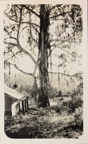 Kew Historical Society Inc
Photograph - Marysville, 1926
Henry Beater Christian (1886-1962) , was a descendant of one of the earliest settler families in Kew. Employed at the Kew Asylum as a 'public servant', he was a skilled amateur photographer, photographing numerous scenes in Kew and on his travels around Victoria. The majority of his photographs date from 1916 to 1929. His finest photographs are housed in two photograph albums. Digital copy of a photograph from page 26 of the 47-page photograph album containing 261 gelatinous silver images, loaned by Diane Washfold with permission given to digitise and hold a copy in our collection. John Chapman has written in 'Bushwalking Clubs - A Brief History', about the establishment in Victoria of the first bushwalking club in 1888, and the popularisation of bushwalking during the interwar period. Henry Christian's 'walks' appear to have been undertaken solely or with a companion/s. On a trip to Marysville in 1926, he focuses on a huge eucalypt beside a bush hut."Marysville / 1-1926"henry beater christian (1886-1962), landscape photography, christian-washfold collection, photograph albums, bushwalking, marysville -
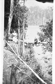 Southern Sherbrooke Historical Society Inc.
Photograph - Allan Currie and three women
Photograph of Allan Currie and three women at Belgrave Reservoir. They are all sitting on a fallen tree, with Allan sitting above the creek. -
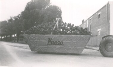 Bendigo Historical Society Inc.
Photograph - HANRO COLLECTION: EASTER FAIR ENTRY
Black and white photo of a Hanro Easter Fair float entry, float appears to be pulled by a tractor and is made up of a tractor trailer decorated to look like a huge basket of flowersorganization, business, hanro, hanro, easter fair -
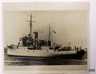 Flagstaff Hill Maritime Museum and Village
Photograph - Vessel, Steam Ship, HMAS Warrnambool J202, Between 1941-1947
The photograph shows the vessel HMAS Warrnambool J202, which was commissioned by the Royal Australian Navy for use as a minesweeper during World War II. The Bathurst Class Corvette, fitted out with a range of armaments, was launched in Sydney 1941. The ship began service in Bass Strait in 1941. At the end of the year it called into its namesake city, Warrnambool, where the crew paraded for the public marching eastwards along Timor Street. A gift of books for the ship’s personnel and a plaque bearing the City of Warrnambool’s Coat of Arms were presented to the ship. The ship was involved in evacuating a family of nine from the Dutch East Indies that was later successful in its challenge of Australia’s Immigration Restriction Act (White Australia Polity). The ship had many other appointments around Australia. On 13th September 1947 HMAS Warrnambool was leading a flotilla of minesweepers in northern Queensland’s coastal waters, clearing mines previously laid to defend Australia. The ship hit a mine, which exploded and very quickly sunk the ship. Boats from the nearby ships rescued most of the seamen although one was killed at the time. The survivors were taken by the HMAS Swan II to Darwin, and they went from there to hospitals in Brisbane and Sydney. Three of these men later died from their injuries. A number of items were recovered by Navy divers in 1948 including the ship’s bell and a plaque with Warrnambool’s Coat of Arms. In 1972-75 the wreck was sold and other items were salvaged. In 1995 a memorial plaque was erected in Warrnambool near the RSL. NOTE: The RAN built a second HMAS Warrnambool FCPB204, launched in 1981 and decommissioned in 2005. There was also a steam ship SS Warrnambool built in London 1892 and broken up in 1926. [A more detailed history can be found in our Collection Record 3477.] This photograph of HMAS Warrnambool is significant for its association with Royal Australian Navy and its vessel, HMAS Warrnambool (J202). The HMAS Warrnambool played a nationally significant role in overturning Australia’s Immigration Restriction Act 1901 (colloquially known as the White Australia policy). The ship rescued, and brought to Australia, Samuel and Annie Jacob and their family after they evacuated Dutch East India. The family was threatened with deportation and made the first successful appeal to High Court regarding that Act. The HMAS Warrnambool has - Local significance for being the namesake of the City of Warrnambool - Local significance, having docked in Warrnambool Harbour - Local significance, the crew having paraded in Timor Street, Warrnambool - State significance for its first patrol being in Bass Strait. - National significance, being present in Timor at the Japanese surrender - National significance, shown by the significance of the ship’s bell being curated as Military Heritage and Technology at the Australian War Memorial. - National significance as part of Australia’s defence force history, being one of only four Bathurst class corvettes lost while in Australian service, the only Bathurst class corvette lost after World War II, the only RAN vessel to be sunk by a mine, and associated with the last four Navy deaths of WWIIPhotograph of HMAS Warrnambool near land. Black and white photograph shows a steam and sail vessel in calm water beside land. Figures are standing on board. A flag flies on a mast. The ship's name is on the stern. The light coloured funnel has emitted a small amount of smoke.On side of ship "WARRNAMBOOL"flagstaff hill, maritime village, maritime museum, warrnambool, shipwreck coast, mort's dock & engineering co ltd, h.m.a.s. warrnambool, hmas warrnambool, hmas warrnambool i, hmas warrnambool j202, hmas swan ii, j202, world war ii, bathurst class corvette, royal australian navy, ran, sydney built ship, bass strait patrol, sea mine patrol, mine sweeper, mine clearance, navy divers, great barrier reef, cockburn reef, southern cross diving and salvage, warrnambool city council, cr j r astbury, mayor j r astbury, warrnambool patriotic fund, seal, coat of arms, dedicatory plaque, hmas warrnambool 1941, shipwreck by sea mine 1947, sinking ship, sunk ship, minesweeper