Showing 86452 items in the category Documentation with item type Photograph
-
 Bialik College
Photograph (Item) - Student playing with lego, c. 1980s, c. 1980s
Student in a classroom playing with lego, c. 1980s. Please contact [email protected] to request access to this record. -
Port Melbourne Historical & Preservation Society
Photograph - Garden City Pensioner's Club at Warburton, 16 Oct 1963
.01 - B&W photocopy of Garden City Pensioner's Club at Warburton (16.10.1963). .02 B&W photocopy of Garden City Pensioner's Club outside St Mary's Parish Hall at Warburton (16.10.1963).Gardengarden city, garden city pensioner's club, st mary's warburton -
 Eltham District Historical Society Inc
Photograph - Digital Photograph, Alan King, Kinglake National Park, 27 March 2008
Fern gullies around Jehosaphat Gully Covered under National Estate. Published: Nillumbik Now and Then / Marguerite Marshall 2008; photographs Alan King with Marguerite Marshall.; p125 The magnificent Kinglake National Park, fringing Nillumbik’s north, is the largest national park close to Melbourne. Thanks to the vision and hard work of a band of local people, the park was created from what was rapidly becoming degraded land. Seeing a threat to Kinglake’s indigenous flora and fauna, several prominent local people campaigned for a national park, which was established in 1928.1 Since then, the park has grown through donations and acquisitions of land, from around 13,800 acres of land (5585ha) to 22,360 hectares. The Sugarloaf and Everard Blocks – of almost 8000 hectares – stand in Nillumbik and the park extends into Mitchell and Murrundindi Shires and the City of Whittlesea. Mt Everard commemorates William Hugh Everard, State member for Evelyn when the park was established. Before 1928, European settlers had degraded the Kinglake area, which was named after the celebrated English author and lawyer, Alexander William Kinglake. Remains of gold shafts and diggings in the park are reminders of Kinglake’s first settlers, who hoped to strike it rich at the gold diggings. But like other gold fields in this shire, they proved not very lucrative and soon timber cutting replaced mining in importance. However, before long, the accessible timber supply ran out, so in the 1920s agriculture took over – particularly potatoes and berry fruits – which involved large-scale clearing.2 The park’s instigator was retired Melbourne University Professor of Music, William Laver.3 As chair of the Kinglake Progress Association he began negotiations to have crown lands on the southern scarp of the Great Dividing Range reserved as a national park. Even before the park was proclaimed, from 1927, KPA members cut tracks to the major scenic points. Professor Laver was one of several people who gave land for the park, donating around 50 acres (20ha), including the Jehosaphat Gully.4 Laver chaired the park’s first Committee of Management, which raised money to employ a ranger and provide facilities, including tracks and roads for fire protection vehicles, toilets and shelters. The committee charged fees for firewood collection, some grazing of livestock, and visitor entrance, and obtained small State Government and Eltham Shire grants. In 1957 the State Government provided revenue for national parks. Then, in 1975, the State Government took over the management and the Committee of Management became an advisory committee, which disbanded in 1978. Originally, the park covered crown land in the Shires of Eltham and Whittlesea; then Wombelano Falls in Yea and other areas were added. In 1970 the park extended into the Shires of Eltham, Healesville, Whittlesea and Yea.5 Bush fires have been an ongoing problem. In 1939 hundreds of eucalypts and acacias had to be sown around the Jehosaphat Gully to rejuvenate the forest. To manage bushfires, the Committee of Management, then the State Government, worked closely with the Forestry Commission, shire councils and local fire brigades. Early national parks focussed on recreation. But by the 1980s, conservation, education and scientific research became more important, playing a vital role in preserving representative samples of the natural environment. Each year many thousands of people use the park’s extensive network of walking tracks amongst the protected plant and animal life as well as camping, cycling and horse riding. The park, along the slopes of the Great Dividing Range, has lookouts revealing magnificent views of the Melbourne skyline, Port Phillip Bay, the Yarra Valley and the You Yangs. Vegetation in the Masons Falls area includes messmate forest, Austral grass-trees, ferns and Hazel Pomaderris. In spring, orchids, lilies, everlasting daisies, correas, grevillea and heath appear. Around Jehosaphat Gully are wet and dry forest, fern gullies and banksia. Animal life includes wallabies, kangaroos, koalas, echidnas, possums, gliders and bandicoots. Male lyrebirds can be heard mimicking in the Jehosaphat Gully, particularly in the Everard Block in winter.This collection of almost 130 photos about places and people within the Shire of Nillumbik, an urban and rural municipality in Melbourne's north, contributes to an understanding of the history of the Shire. Published in 2008 immediately prior to the Black Saturday bushfires of February 7, 2009, it documents sites that were impacted, and in some cases destroyed by the fires. It includes photographs taken especially for the publication, creating a unique time capsule representing the Shire in the early 21st century. It remains the most recent comprehenesive publication devoted to the Shire's history connecting local residents to the past. nillumbik now and then (marshall-king) collection, kinglake national park, jehosaphat gully -
Glenelg Shire Council Cultural Collection
Photograph - Photograph - Machinery, n.d
Port of Portland Authority Archivesport of portland archives -
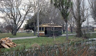
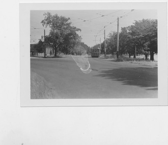 Ballarat Tramway Museum
Photograph - Tram 26 at View Point looking Sth, Ken Magor, Early 1950s
Tram 26 at intersection of Wendouree Pde and Macarthur St intersection. Location was known by Ballarat Tramways as View Point.Yields information on Tram 26 and the View Point locationBlack and White photograph on plain paper5, A1, KEN MAGOR, Neg. No.1403ballarat, wendouree parade, macarthur st, view point, tram 26 -
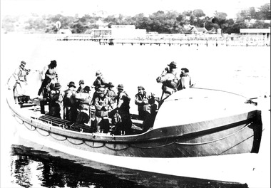 Queenscliffe Maritime Museum
Photograph - Black & white photograph of lifeboat Queenscliffe with crew, Lifeboat at Queenscliffe, c1920
16 oared lifeboat with crew at QueenscliffeLifeboatBlack & white photo of a 16 oar lifeboat at QueenscliffeReverse - " circa 1920? - see Frank (Ferrier?) "historical references, lifeboat -
 Eltham District Historical Society Inc
Photograph, A walk through the cemetery at Kangaroo Ground, Diana Bassett-Smith, 1 October 2001, 2001
Another of a good friend and neighbour, Jean Stewart. Lloyd's wife and the mother of Mardi Crocker whose son Zac played with our G'son Richard last weekend. A brief collection of reminiscences by Diana Bassett-Smith of locals who are buried at Kangaroo Ground Cemetery along with 17 photographs following a visit on 1 October 2001.Colour photograph print1983 bushfire, air vice marshall wackett, ambrose erswell, barry roach-pierson, bill pelling, billy roach-pierson, birrarung, bourchiers road, ca 13, crichton, david grant, diamond street, diana bassett-smith, donald grant, donaldson road, dorrie bourchier, duff, early settlers, elizabeth cottee, ewan cameron mp, grey house, helen kohn, isabella grant (nee stevenson), jack bourchier, james balfour, james wilson, jean stewart, jessie bull (nee haughton), jimmy cook, jocelyn, joseph stevenson, judge book village, judith furphy, kangaroo ground cemetery, kay roach-pierson, keith jocelyn, kraft foods, lacey, lloyd stuart, louise grant (nee gordon), mardi crocker, marion erswell, ned haughton, nursery, pam chevallier, passiona, peter bassett-smith, pigeon bank, rath, ricketson, robinson, ruth boyd, steven crawford baes, tintagell, tosch, vera jackson, wackett trainer, watershed jackson, willandra poultry farm, zac crocker -
Stawell Historical Society Inc
Photograph, Commonwealth Federation Monument in Main Street Stawell 1904, 27 December 1904
Commonwealth Memorial Lower Main Street StawellErected in Honor of First ParlimentPostcard with Stamp of Commonwealth Monument Main Street. Boys Sitting around BaseFront- Souvenir From Stawell (Victoria) A Picard - Stawell) Commonwealth Monument. Rear - Miss K A Simpson Young House Parkside S.A.stawell -
 Surrey Hills Historical Society Collection
Photograph - 35 Sunbury Crescent, Surrey Hills, The Street Where You Live Project
Photos documenting this address as part of a photographic series undertaken by volunteer photographers during 2013 and 2014 for The Street Where You Live Project. This was organised through the Surrey Hills Neighbourhood Centre and covered the postcode 3127 in the cities of Boroondara and Whitehorse.These photos provide a snapshot of real estate in the suburbs of Mont Albert and Surrey Hills during a period of rapid change with many properties on large blocks demolished to create higher density residential development or renewal of single dwellings. At particular risk were properties not covered by heritage overlays, especially interwar housing and post 1950's housing. -
 Ballarat Tramway Museum
Photograph - Colour Photograph/s, David Endacott, 1971
Colour print of a Ballarat No. 13 en route for the Gardens, just past St Aidans Drive during the winter of 1971. Photo taken from partly within Lake Wendouree, looking at the tramcar through the trees, before it has passed the photographer. See also Reg Nos. 1278 and 1279 for related images. On Kodak paper. Tram has a Twin Lakes advertisement on the front dash panel. Homes along St. Aidans drive can be seen in the background. Original film image scanned at 3200dpi 12/5/2020.On rear in blue ink "Lake Wendouree" and in top left hand corner "1971".ballarat, lake wendouree, st aidans drive, tram 13 -
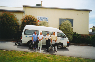 Mission to Seafarers Victoria
Photograph - Photograph, Colour
Pat Danne, volunteer, and three seamen standing outside the Hastings Seafarer Centre' shuttle bus with golfing gear at the entrance of the Devilbend Golf Club in the Mornington Peninsula.hastings mission, mission to seafarers, golf, equipment, van, pat dann, sailors, seamen, welfare -
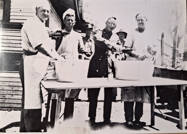 Tatura Irrigation & Wartime Camps Museum
Photograph, Christmas Pudding
Making of the Christmas pudding at Camp 4. Captain Scates in the middle. Black and white photograph of 6 men, 4 in front and 2 behind. 3 of the 4 men in front in white aprons the other in uniform. The two men in background are in uniform. They are pouring liquid into two big tubs, making Christmas pudding.christmas pudding, camp 4 kitchen staff, captain scates -
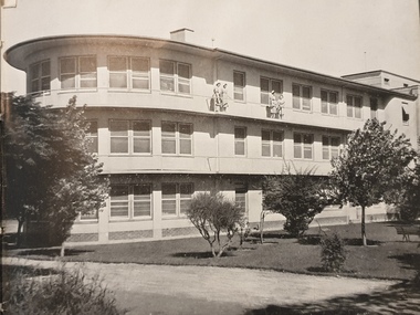 Ballarat Heritage Services
Photograph, Building
Three storey building.building, architecture -
 Surrey Hills Historical Society Collection
Photograph, Surrey Hills Wesleyan Sunday School teachers, Before 1888
Donor identification was that man in back row on left was Henry Beckett; 2nd from left was Emma Beckett, later Mrs John Gray. The Beckett family were important in the establishment of the Wesleyan / Methodist church in Surrey Hills and adjacent areas. Emma Beckett married John Gray in 1888 at 'Guildford Villa' in Essex Road, Surrey Hills which was the Beckett family home.B&W photo of a group of 15 women and 9 men standing and seated in front of a light-coloured weatherboard wall. surrey hills wesleyan sunday school, surrey hills wesleyan church, surrey hills methodist church, churches, (mr) henry beckett, (miss) emma beckett, (mrs) john gray, beckett family -
Glenelg Shire Council Cultural Collection
Photograph - Photograph - Main Breakwater Construction, 06/12/1960
Port Of Portland Authority ArchivesFront: F1 '6-12-60' - pencil Back: F1 '6/12/60' - Pencilport of portland archives, portland harbour, breakwater -
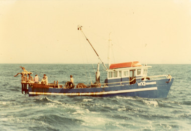 Lakes Entrance Historical Society
Photograph - Yarrandoo, 1980
Colour photograph of the scallop fishing boat Yarandoo, showing two people at dredge table, one other person on deck in Bass Strait off Lakes Entrance Victoriaboats and boating, fishing industry, ocean -
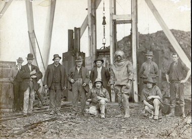 Bendigo Historical Society Inc.
Photograph - TAMBOUR MAJOR MINE AT SPECIMEN HILL, 1920
Black and white photograph mounted on brown board. Ten males in front of mine shaft. One male in divers suit. Male second from L holding small dog. Cage and poppet legs in background. Mullock heap at back. Inscriptions: Hand written on BR corner of photo 'Percival Pinder, Photo, Bendigo' Hand written on board under photo 'Tambour Major GM Coy 846 ft'. On separate card glued to bottom of mount board, printed 'Diver inspecting flooded Tambour Major Mine at Specimen Hill in 1920'. Hand written in ball point pen on back 'Tambour Major' Mine Group photo taken at Tambour Major about 1920. Dad on extreme right, Joe Sheard, Mine Manager in diving suit. A Richardson, 29 Harrison Street' Hand printed in black ink on back 'Diver inspecting flooded Tambour Major Mine in 1920'. On back - circular purple stamp 'Royal Historical Society of Victoria, Bendigo Branch'.Percival Pinder, Bendigomining, surface equipment, tambour major mine, bendigo, mines and mining, miners, mine, specimen hill, flooded mine, diver -
 Stawell Historical Society Inc
Photograph, Ledcourt School Students in sack race
Ledcourt School Sports Teacher Winnie Cunningham Dr Andrew Cunninghams Aunty Bill Cunningham Loraine Pickering Margaret Howard Neville Howard Students in sack race with teacher on right education -
City of Kingston
Photograph - Black and white, 20 December 1945
This photograph depicts a section of Cheltenham with a mix of housing and market gardens. The visible market gardens, farms and paddocks have gradually been sub-divided into housing, commercial and industrial estates. A large part of Cheltenham was originally established as a rural market gardening community. The railway line and station brought urban development to the area and the gradual subdivision of farmland and large land holdings for the development of housing. Aerial photograph dated 1945 of the Cheltenham area in the City of Kingston. Sydney Street (bottom left); Sinclair Street (top left); Weymar Street area off Wilson Street, Charles Street (botton right).White print VIC-170; 57197; RUN5; PROJ.No.5; MELB.METROP AREA Lens information [indecipherable] Small photograph: clockface Black ink: 57197cheltenham, market gardens, urbanisation -
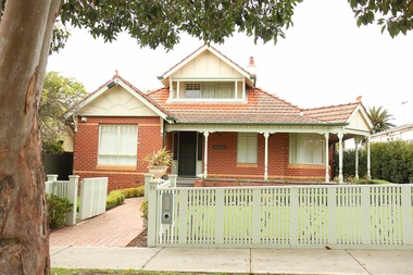 Surrey Hills Historical Society Collection
Photograph - 29 James Street, Surrey Hills, The Street Where You Live Project
Photos documenting this address as part of a photographic series undertaken by volunteer photographers during 2013 and 2014 for The Street Where You Live Project. This was organised through the Surrey Hills Neighbourhood Centre and covered the postcode 3127 in the cities of Boroondara and Whitehorse.These photos provide a snapshot of real estate in the suburbs of Mont Albert and Surrey Hills during a period of rapid change with many properties on large blocks demolished to create higher density residential development or renewal of single dwellings. At particular risk were properties not covered by heritage overlays, especially interwar housing and post 1950's housing. -
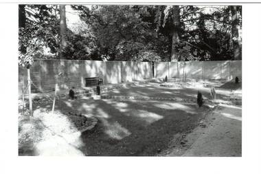 Buninyong & District Historical Society
Photograph - B/W photograph, Clive Brooks, Old Swimming Baths, Buninyong Botanic Gardens, 9 April 1994
Shows restoration of old swimming baths, and conversion to enclosed garden nearing completion.B/W photo of old Swimming Baths in Buninyong Botanic Gardens, constructed by Shire Engineer C P Wilson c 1919 around existing pool. Photo taken during refurbishment/conversion to walled garden. Old baths filled in, preparation for sunken lawn, bluestone edging, some planting in place.buninyong, swimming baths, botanic gardens, c p wilson -
Malmsbury Historical Society
Photograph (Item), Barb Slimmon At Daffodil Exhibition 1991, Malmsbury 4/9/1991
People - "Slimmon, Barb; Manktelow, Dennis" Associated with - "Mhs, Heritage Festival" -
 Ballarat Heritage Services
Photograph - Photograph - Colour, Corner of Vickers Street and Albert Street, Sebastopol, 2020, 07/04/2020
The South Star Mine commenced operations in the 1880s and worke the quartz laods after the great floods of 1875 forced the closure of most alluvial mines. The South Star Mine sunk its first shaft in 1886, but broke into old alluvial workings and had to be abandoned because of flooding. The second shaft commenced in 1887, and was the deepest eer sunk in the Ballarat district, reaching 956 metres. 180 men worked three shifts each day.Colour photograph of the site of the South Star Mine in Sebastopol. sebastopol, albert street, south star mine, mining -
Canterbury History Group
Photograph - Street view of the enamelled picture plaque of the former Canterbury Station, Jan Pigot, 2004
Coloured photograph of the street view of the enamelled picture plaque of the former Canterbury Station on the brick wall at No. 111 Maling Road, Canterburycanterbury, maling road, theatre place, shops, signs, plaques -
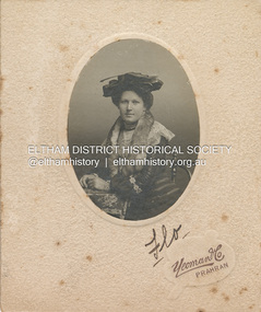 Eltham District Historical Society Inc
Photograph, Yeoman and Co, Florence May Shillinglaw, c.1906
Florence May Shillinglaw born September 21, 1886 at Eltham, Victoria was the tenth child of Phillip Shillinglaw and Sarah Ann (nee Kidd). She commenced school at Eltham State School No. 209 (Register No. 552) in 1891 at age 4. She married Edward Thomas Bunker September 6, 1906 and they had eight children all born in Eltham where they had a cherry orchard and all lived full lives. Florence died July 26, 1969 at Ivanhoe."Mary Shillinglaw"marg ball collection, 1883-1918, 1906, florence may bunker (nee shillinglaw) (1886-1969), yeoman & co photographer prahran -
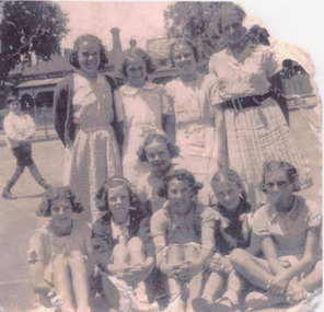 Port Melbourne Historical & Preservation Society
Photograph - Nott Street girls netball team, 1920s - 1940s
Series of photos loaned for copying by Thelma Nixon Edgar and Emily Nixon Davis.13 - Nott St girls netball team 1937. Emily Nixon Davis is at top leftfamilies, montague, sam nixon, mary nixon, thelma nixon edgar, emily nixon davis -
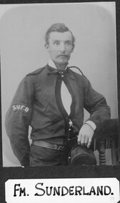 Stawell Historical Society Inc
Photograph, Stawell Fire Brigade's Fireman Sunderland 1885 -- Studio Portrait
Portrait. Fm. Sunderland. Stawell Fire Brigade 1885 stawell -
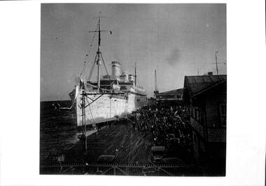 Port Melbourne Historical & Preservation Society
Photograph - German liner, Reliance, Inner East Station Pier, Port Melbourne, 6 Apr 1938
B&W lasercopy of photo of Station Pier 6.4.1938 and the German liner 'Reliance' at Inner East Berth. Over gatehouse can be seen the funnels and mast tops of Empress of Britain.transport - shipping, piers and wharves - station pier, reliance, empress of britain -
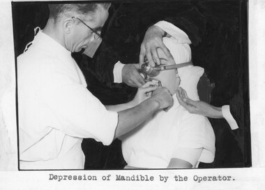 Geoffrey Kaye Museum of Anaesthetic History
Photograph
Black and white photograph of a demonstration of a dental procedure on a patient who is receiving anaesthesia. Dr Geoffrey Kaye, wearing a white gown, is holding an instrument to the patient's mandible. An anaesthetist's hands are supporting the patient's head and administering anaesthesia to the patient through an inhaler. A fourth person's hand is holding a mouth gag dental instrument in the patient's mouth. The background of the photo has been covered with black ink so that only Dr Kaye, the patient, and the hands of the anaesthetist and fourth person are visible.•Printed text in black ink on paper label glued under photo: Depression of Mandible by the Operator. •Handwritten with blue ink on reverse: Photo. 5. / (Frame 22).dental procedure, dental instrument, anaesthesia, anaesthetist, patient, geoffrey kaye -
Moorabbin Air Museum
Photograph (Item) - Assorted RAF B24 B&W Photos