-
 Eltham District Historical Society Inc
Negative - Photograph, J.A. McDonald, Inspection of storm damaged Abraham house at Kangaroo Ground, c. May 1962
Showing the effect of a wind storm that destroyed the house circa May 1962.. The Abraham family owned land near the Aqueduct and east of Nicholas Lane at Kangaroo Ground (based on photos, at or near 40 Nicholas Lane).Record of various Shire of Eltham infrastructure works undertaken during the period of 1952-1962 involving bridge and road reconstruction projects, sometimes with Eltham Shire Council Project Reference numbers quoted. It was during this period that a number of significant improvements were made to roads and new bridges constructed within the shire that remain in place as of present day (2022). In many situations, the photos provide a tangible visible record of infrastructure that existed throughout the early days of the Shire. The album was put together by or under the direction of the Shire Engineer, J.A. McDonald.1962-05, abraham house, kangaroo ground, nicholas lane, property damage, storm damage, building surveyor, george e. newton -
 Moorabbin Air Museum
Plan (Item) - Drawing Exterior Finishing Scheme Orion P3-B Aircraft , Drawing A16194, Sheet 1 Of 5 Sheets
-
Moorabbin Air Museum
Plan (item) - Bristol Aeroplane 170 schematic drawings, Ass. of Cut Out Switches
Bristol Aeroplane Company Ltd -
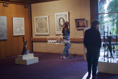 Eltham District Historical Society Inc
Negative - Photograph, Art show, Eltham Community Centre, c.1994
Art show held in the Eltham Community CentreRoll of 35mm colour negative film, 1 stripKodak Gold 100-4art exhibition, eltham community centre -
Kew Historical Society Inc
Plan - 30 Choice Home Sites in Kilby Road, Meldrum Street and Fairway Drive, 1965
Subdivision plans and real estate flyers/brochures reveal a number of aspects of urban development and history. The Kew Historical Society's collection of these plans, as well as advertisements extracted from magazines, cover key aspects of community development and architectural history of Kew and Kew Eat as well as surrounding suburbs. While most of the plans in the collection were gifted to the Society by the former City of Kew, a number of other plans and advertisements have been donated by individuals, of which this is an example.Original 4-page, bifold brochure, one of two in the collection, of home sites created following the creation of the Eastern Freeway which separated a section of land owned by the Kew Golf Club from the main course. The new estate featured 30 lots in Meldrum Street, Kilby Road and Fairway Drive.subdivisions -- kew east (vic.), subdivisions -- kew (vic.), kew golf club -
Port Melbourne Historical & Preservation Society
Plan - Handcoloured location of Libbis family members' homes on copy of a section of 1894 MMBW map, 1894
Obtained from MMBW by Peter Libbis when researching Libbis family historyPhotocopy of a section of 1894 MMBW plan 118 which has been handcoloured to indicate locations such as homes of various Libbis family membershandcoloured to indicate locations such as homes of various Libbis family membersbuilt environment, families, peter libbis -
 University of Melbourne, Burnley Campus Archives
Negative - Black and white negative, Garden View, 1922-1923
Garden Viewj.l. provan, garden view -
Port Melbourne Historical & Preservation Society
Plan, "State Bank of Victoria - Proposed dwelling Fishermans Bend"
Plans were brought to us for copying 19.05.2011 by CBA employee Steve Tserkezidis, who has access to old State Bank records. Borrowed for scanning by Gavin Rowson who put them on CD and returned 07.06.2011From series of State Bankhouse plans and elevations of types 1 - 8. A1 copies (.01) 1937 (stamp). (.02) 1928. (.03) 1937. (.04) 1937. (.05) no date. (.06) 1928. (.07) 1937. (.08) 1938. From plans accompanying bank House plans .01 to .08; (.09) MMBW plan showing bank properties (.10) Bank house plan: sections through walls. (.11) "Fishermans bend group" plan of properties (.12) Bank House plan of Pier Foundationgarden city, built environment - domestic, state savings bank of victoria, bank houses -
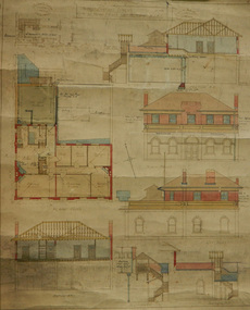 Mission to Seafarers Victoria
Plan - Architectural drawings, Walter Butler, 1916
An original group of plans drawn by Walter Butler who was also the architect of the Central Institute, Siddeley Street in 1906 and the Mission to Seamen building at 717 Flinders St that is still in use today. The early Port Melbourne onshore Mission gradually transformed from a 'wooden shack' to a one storey brick building designed by architect Frederick Williams in 1888. The St Nicholas chapel was added in 1915. Walter Butler was commissioned to add a second storey in 1917. The building retained its functions until 1937 when the Art Deco Mission, designed by Morris was built. The building has survived as a structure into the 21st century, and was incorporated as part of a multi-apartment development. Historical architectural record of Walter Butler's work. Walter Butler was a renowned architect and friend of the Fairfax family.Coloured architect's drawings of the proposed plans for Chaplain's Residence at Port Melbourne on heavy parchment. Including elevation drawings, floor plans and cross sections as well as architect's notes and measurements.Embossed architect's stamp in top right and left corners and bottom right corner "Walter R Butler [indecipherable] Melbourne" Printer's stamp on bottom right hand corner of rear "Printed by J. Creffield Propy. LTD. RIALTO, 493-5 Collins St. Melbourne"plans, walter richmond butler (1864–1949), mission to seafarers, chaplains residence, beach street, nott street, port melbourne, mission to seamen, frederick williams -
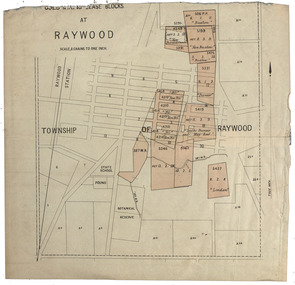 Federation University Historical Collection
Plan, Raywood Gold Mining Lease Blocks, c1986
Raywood is in the State of Victoria.Gold mining lease blocks at Raywood. Thought to be from The Gold-Fields of Victoria Reports of The Mining Registrars for the Quarter Ended 30th June 1886raywood, raywood botanical gardens, pound, raywood state school, buxton, new buxton, new perserverance, pioneer, new nil, south pioneer and may reef, london -
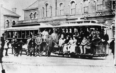 Melbourne Tram Museum
Negative, 11/11/1885
Copy negative of a photograph of the opening of the Richmond Cable Tramway 11/11/1885 Has the Richmond Town Hall in the background. See Reg Item 4643 for a prints ex Keith Kings and Colin Jones.On rear of Photo ex Colin Jones "Copied 14/2/83" in two locations "150L 76%^ B/W? and on bottom edge "MMTB 1885".trams, tramways, cable trams, mto co, opening, richmond -
 Kew Historical Society Inc
Plan - Subdivision Plan, Plan of Subdivision of Part of Crown Portion 84 / Parish of Boroondara / County of Bourke / Lodged Plan No. 2217, Twentieth Century
Pru Sanderson, in her groundbreaking ‘City of Kew Urban Conservation Study : Volume 2 - Development History’ (1988), summarised the periods of urban development and subdivisions of land in Kew. The periods that she identified included 1845-1880, 1880-1893, 1893-1921, 1921-1933, 1933-1943, and Post-War Development. These periods were selected as they represented periods of rapid growth or decline in urban development. An obvious starting point for Sanderson’s groupings involved population growth and the associated economic cycles. These cycles also highlighted urban expansion onto land that was predominantly rural, although in other cases it represented the decline and breakup of large estates. A number of the plans in the Kew Historical Society’s collection can also be found in other collections, such as those of the State Library of Victoria and the Boroondara Library Service. A number are however unique to the collection.The Kew Historical Society collection includes almost 100 subdivision plans pertaining to suburbs of the City of Melbourne. Most of these are of Kew, Kew East or Studley Park, although a smaller number are plans of Camberwell, Deepdene, Balwyn and Hawthorn. It is believed that the majority of the plans were gifted to the Society by persons connected with the real estate firm - J. R. Mathers and McMillan, 136 Cotham Road, Kew. The Plans in the collection are rarely in pristine form, being working plans on which the agent would write notes and record lots sold and the prices of these. The subdivision plans are historically significant examples of the growth of urban Melbourne from the beginning of the 20th Century up until the 1980s. A number of the plans are double-sided and often include a photograph on the reverse. A number of the latter are by noted photographers such as J.E. Barnes.Undated Plan of Subdivision of Crown Portion 84 in what is now Kew. The area shown is bordered by Burke Road, Harp Road, Arglye Road and Normanby Road.subdivision plans -- kew (vic), harp road, burke road, normanby road, lady loch's drive, gladstone street, second avenue, first avenue -
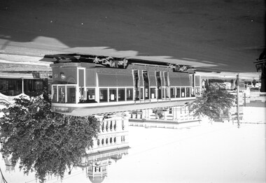
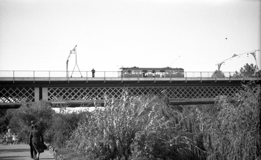 Melbourne Tram Museum
Negative, Wal Jack, c1941
Black and white negative, by Wal Jack, of W2 392 (from information in the Wal Jack Album) crossing the Swan St or Wallen St bridge over the Yarra River. Photo not dated, in the Wal Jack album.trams, tramways, swan st, wallen road, bridges, w2 class, yarra river, tram 392 -
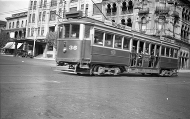
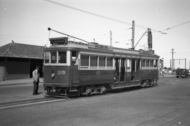 Melbourne Tram Museum
Negative - Set of 2, Wal Jack, 27/12/1939 12:00:00 AM
Set of two Black and white negatives of Victorian Railways tram 35 at the Brighton Station terminus - 27-12-1939. Tram has adverts for Robur tea. .1 - has the Motorman looking at the bogie. In the background is the waiting shelter at the terminus and an advert for Dandy Ham - get on for Christmas. Photo in the Wal Jack Victorian Railways Album which provides the date.trams, tramways, victorian railways, vr trams, brighton, motormen, tram 35 -
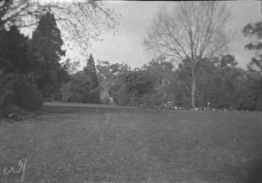
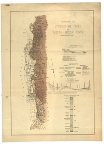 Federation University Historical Collection
Plan, Livinstone Creek and Mitta Mitta River
Plan showing geological eras and soil types. Scale 80 chains to 1 inchmitta mitta, mitta mitta river, hinnomunjie flats, mining, shafts, livingstone creek -
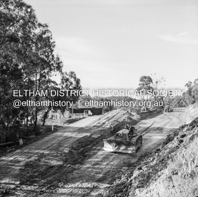 Eltham District Historical Society Inc
Negative - Photograph, J.A. McDonald, Heidelberg-Kinglake Road, Sep. 1959
Job 56M430 Contractor Hone Deviation opposite looking north from Hurstbridge endRecord of various Shire of Eltham infrastructure works undertaken during the period of 1952-1962 involving bridge and road reconstruction projects, sometimes with Eltham Shire Council Project Reference numbers quoted. It was during this period that a number of significant improvements were made to roads and new bridges constructed within the shire that remain in place as of present day (2022). In many situations, the photos provide a tangible visible record of infrastructure that existed throughout the early days of the Shire. The album was put together by or under the direction of the Shire Engineer, J.A. McDonald.infrastructure, shire of eltham, road construction, 1959-09, heidelberg-kinglake road -
 Melbourne Tram Museum
Negative, Wal Jack, 9/10/1938 12:00:00 AM
Black and white negative, of Victorian Railways trams 36 crossing Fitzroy St St Kilda, with the George Hotel in the background. Photo in the Wal Jack Victorian Railways Album - dated 9-10-1938trams, tramways, victorian railways, vr trams, st kilda, fitzroy st, tram 36 -
 Ballarat Tramway Museum
Negative, Wal Jack, c1946
Yields information about the appearance of the ex Melbourne bogie trams the city tram stop.Negative and Digital image of the Wal Jack Ballarat Negative file of bogie car No. 15, when "new" to Ballarat, c1946 at Sturt and Lydiard streets. Has the Commonwealth Bank, the National Mutual building and the trams, tramways, drummond st nth, sturt st, tram 15 -
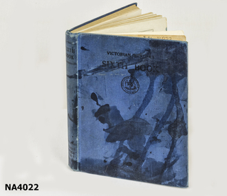 Whitehorse Historical Society Inc.
Education kit - Book - reader
From the Till collectionBlue covered Victorian reader. Sixth bookAlwyn Till (name of child)books, children's -
Moorabbin Air Museum
Plan (item) - C.A.C Turbojet Trainer A.S. Viper XP.59 P269
-
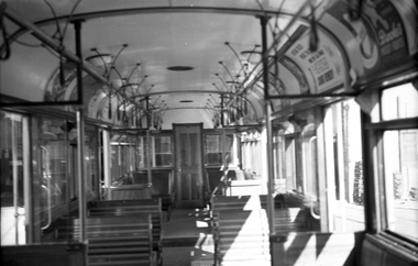 Melbourne Tram Museum
Negative, Wal Jack, c1941
Black and white negative, by Wal Jack, of an interior view of SW6 844. Photo undated, in the Wal Jack album but given as the car number. c1941.trams, tramways, sw6 class, interiors, tram 844 -
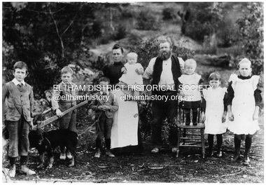 Eltham District Historical Society Inc
Negative - Photograph, Sabina and Will Mills and family, Upper Diamond Creek (Wattle Glen), c.1899
Sabina and William Henry Mills lived at "Golden Valley", Upper Diamond Creek (Wattle Glen) and had nine children in total. Here they are pictured with seven young children. Sabina died in 1916 aged 57 and William died in 1921 age 64. They are buried together at Diamond Creek (Nillumbik) cemetery. Reproduced on p46 of 'Pioneers & Painters'This photo forms part of a collection of photographs gathered by the Shire of Eltham for their centenary project book, "Pioneers and Painters: 100 years of the Shire of Eltham" by Alan Marshall (1971). The collection of over 500 images is held in partnership between Eltham District Historical Society and Yarra Plenty Regional Library (Eltham Library) and is now formally known as 'The Shire of Eltham Pioneers Photograph Collection.' It is significant in being the first community sourced collection representing the places and people of the Shire's first one hundred years.Digital image 4 x 5 inch B&W Neg 20 x 25 cm printsepp, shire of eltham pioneers photograph collection, wattle glen, sabina mills, will mills, mills family, pioneers and painters, upper diamond creek -
Glenelg Shire Council Cultural Collection
Plan - Plans - Line Drawing Port of Portland Authority, n.d
Port of Portland AuthorityFront: '36' - black texta, top right corner 'Total length cradle 24, outside' - black pen -
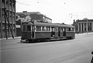 Melbourne Tram Museum
Negative, Wal Jack, 1940's
Black and white negative by Wal Jack of W5 808 (Toorak Route 8) in Victoria St, shunting. Has the Army Recruiting centre in the background and a building advertising Goodyear tyres and tubes. Photo undated, c1940.trams, tramways, victoria st, route 8, shunting, w5 class, tram 808 -
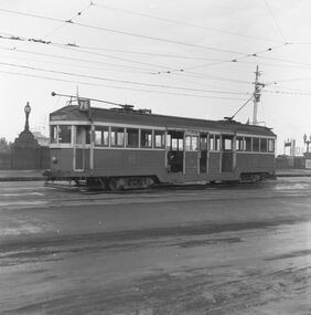 Ballarat Tramway Museum
Negative, Geoff Grant, 7/05/1955 12:00:00 AM
Negative No. 291 and colour print made by colour laser printer (stored in folder ) of W2 440 leaving Batman Avenue terminus on route 76 Camberwell Depot? on 7/5/1955. Photo by Geoff Grant. Hi res scan of negative and image updated 19/5/2020.trams, tramways, melbourne, batman ave, tram w2 440 -
University of Melbourne, Burnley Campus Archives
Plan, Plan of Richmond Park, 1872
Plan of Richmond Park L4461. Shows Horticultural Society's Garden without extra land used for Field Station (see 11.0363, but earlier). Photo-lithographed at the Department of Lands and Survey, 6th Sept. 1872.Handwritten notes on reverse and another railway line marked in pencil.richmond, parks, field station -
Moorabbin Air Museum
Plan (item) - Bristol Aeroplane 170 schematic drawings, Port Side Panel Harness
Bristol Aeroplane Company -
Glenelg Shire Council Cultural Collection
Plan - Plans / Line Drawing Port of Portland Slipway - bilge blocks, Trawler 'Wilson's Pride', 30/07/1987
Front: '43' - black texta, top right corner 'Job No 3003' - black penport of portland -
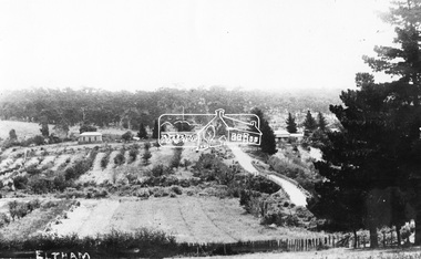 Eltham District Historical Society Inc
Negative - Photograph, Bridge Street, Eltham, c.1910
View from Maria Street (Main Road) along Bridge Street, Eltham, looking towards Montmorency. The house on the right at the corner of Susan and Bridge streets was owned for many years by the Hill family until Council bought it in the early 1960s. The house was built in the 1850s or 60s. The house on the left stood on what is now the southwest corner of Susan and Bridge Streets. The Braithwaite family was associated with this house. Orchards in the foreground either side of the Diamond Creek. The line of trees running up the hill to the left represents the Bolton street alignment. Based on hand writing of title on image compared with others, date is estimated at c.1910.This photo forms part of a collection of photographs gathered by the Shire of Eltham for their centenary project book,"Pioneers and Painters: 100 years of the Shire of Eltham" by Alan Marshall (1971). The collection of over 500 images is held in partnership between Eltham District Historical Society and Yarra Plenty Regional Library (Eltham Library) and is now formally known as the 'The Shire of Eltham Pioneers Photograph Collection.' It is significant in being the first community sourced collection representing the places and people of the Shire's first one hundred years.Digital image 4 x 5 inch B&W Negshire of eltham pioneers photograph collection, bolton steet, braithwaite, bridge, bridge street, bridge street bridge, eltham, hill family home, susan street, orchards -
 Eltham District Historical Society Inc
Negative - Photograph, Construction work, Main Street Bridge, Greensborough, c.Dec. 1983
The original bridge over the Plenty River was replaced by a single lane bridge each way fed by two lanes each way on either side. As traffic grew a second bridge was added to complete the divided road across the riverFilm - Kodak CM 400 5079 7 strips, 26 framesinfrastructure, roads, bridge construction, greensborough, main street bridge, road construction