-
 Melbourne Tram Museum
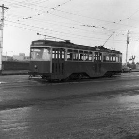
Negative, Wal Jack, 20-4-1945?
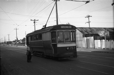
Black and white negative, by Wal Jack, of S 157 in Gordon St (possibly near Monash St.) Tram has the "Special E" destination indicating it was on an Explosive factory working. Note the CGA (Commonwealth Government of Australia) sub-station for the works on the other side of the road. There is a high voltage power line in the background and behind the substation. Could be very near the terminus as no passengers. Photo not dated in Wal Jack album. Could be the same date as Reg Item 5446 - 20-4-1945.trams, tramways, gordon st, footscray, world war 2, special e, s class, tram 157 -
 Eltham District Historical Society Inc
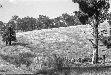
Negative - Photograph, J.A. McDonald, Rattray Road East, Montmorency, 1 May 1961
From south boundary lot looking along proposed alignment 1 May 1961Record of various Shire of Eltham infrastructure works undertaken during the period of 1952-1962 involving bridge and road reconstruction projects, sometimes with Eltham Shire Council Project Reference numbers quoted. It was during this period that a number of significant improvements were made to roads and new bridges constructed within the shire that remain in place as of present day (2022). In many situations, the photos provide a tangible visible record of infrastructure that existed throughout the early days of the Shire. The album was put together by or under the direction of the Shire Engineer, J.A. McDonald.1961-05-01, infrastructure, montmorency, rattray road, road construction, shire of eltham -
 University of Melbourne, Burnley Campus Archives
Plan, Steve Mullany, Energy Education Centre, 1988
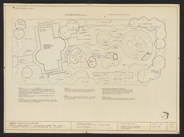
(1) Tracing paper and paper plans, Preliminary Landscape Plan by Steve Mullany, Lecturer Amenity Horticulture Dept. V.C.A.H. Burnley, Sheet 1 of 1 May 2, 1988. (2) 1 tracing paper and 2 paper copies State Schools' Nursery: Proposed Landscape Working Drawing Energy Education Centre Burnley by E.A.H. June 1988. (3) 2 copies State Schools' Nursery: Proposed Landscape Working Drawing Energy Education Centre Burnley, by EAH 18 June 1988 (Details). (4) 2 copies as (3) Pond Plans & Details 16 June 1988. (5.) Designs for small plans of above.vcah, steve mullany -
 Clunes Museum
Negative - NEGATIVES CLUNES HOSPITAL
TWO NEGATIVES OF THE CLUNES HOSPITALnew clunes hospital, negatives clunes hospital -
 Eltham District Historical Society Inc
Negative - Photograph, Tom Prior, Feminine reception for the U.S. Fleet near Research, Victoria, 1908
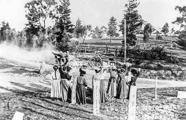
With the visit of the American Fleet to Melbourne in early September 1908, volunteers from the the Automobile Club of Victoria took 100 officers on an excursion to the Black Spur past Yarra Glen on the 4th September 1908. (The area we know today as the Yarra Valley). The convoy travelled through Eltham, Research and Kangaroo Ground, where a group of women gathered to wave to them. This was one of the first motor vehicles to pass through Research. The visit of the American Fleet was a big deal at the time. A Program of activites was compiled. City buidlings were illuminated, a State reception was given and a concert was held. The Federal Parliament sat in Melbourne at that time. This photo was made using a home-made camera constructed by the photographer Tom Prior (brother of Mrs E.R. Reynolds). Reproduced on p86 of 'Pioneers & Painters'This photo forms part of a collection of photographs gathered by the Shire of Eltham for their centenary project book,"Pioneers and Painters: 100 years of the Shire of Eltham" by Alan Marshall (1971). The collection of over 500 images is held in partnership between Eltham District Historical Society and Yarra Plenty Regional Library (Eltham Library) and is now formally known as 'The Shire of Eltham Pioneers Photograph Collection.' It is significant in being the first community sourced collection representing the places and people of the Shire's first one hundred years.Digital image 4 x 5 inch B&W Negsepp, shire of eltham pioneers photograph collection, research (vic.), u.s.a. fleet, automobile club of victoria, drive, excursion, visitors, welcome, usa fleet, us fleet, waving, tom prior, pioneers and painters, reynolds prior collection, u.s fleet -
 Eltham District Historical Society Inc
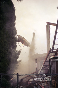
Negative - Photograph, Harry Gilham, Demolition of Eltham Shire Offices, 895 Main Road, Eltham, Aug. 1996
The Shire Offices opened in 1965 and were extended in 1971. The final Eltham Shire Council meeting was held in December 1994 before the forced amalgamations of municipal councils by the Kennett Government. The State-Government-appointed Commissioners (1994-1996) took the decision in July 1996 to demolish the Eltham Shire Offices. The demolition works started within 24 hours of the decision being made.Roll of 35mm colour negative film, 5 of 6 strips Associated colour printKodak Gold 100-5eltham shire office, demolition, shillinglaw trees -
 Eltham District Historical Society Inc
Negative - Photograph, Construction work, Main Street Bridge, Greensborough, c.Dec. 1983
The original bridge over the Plenty River was replaced by a single lane bridge each way fed by two lanes each way on either side. As traffic grew a second bridge was added to complete the divided road across the riverFilm - Kodak CM 400 5079 7 strips, 26 framesinfrastructure, roads, bridge construction, greensborough, main street bridge, road construction -
 Eltham District Historical Society Inc
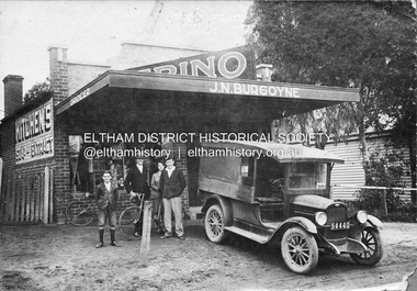
Negative - Photograph, J.N. Burgoyne’s store, Main Road, Eltham, Vic, c.1930
The photo is of John Neville and Ethel (Polly) Burgoyne’s store with eldest children and a 1927/28 model Chevrolet 1 ton truck. The store was located on Main Road just south of Bridge Street (present day No. 820 Main Road). L-R (unconfirmed): Francis (Frank) Neville Burgoyne (1916-2002), unidentified, Mary Frances Burgoyne (1914-1991) and John (Jack) William Burgoyne (1913-2005) which would date the picture as circa 1929/1930. Henry Charles Burgoyne (1920-1994) and Royston (Roy) Edward Burgoyne (1922-2004) not in picture. The unidentified male is believed to be an early boyfriend of Mary Frances at the time, not Reginald John Squire (1916-1981) whom she married in 1938 who was two years her junior. The new store was built in late 1925. At the same time Mr C. Nicholls’s new store was constructed. Both were considered modern shops, and an improvement on most, business establishments of the time. Mr. Nicholls’s store included alongside it a modern, weatherboard villa residence. Mr. Burgoyne’s store incorporated the post and telegraph office, which was operated by John Neville Burgoyne’s half-aunt, Miss Anne Hunniford. The unsealed footpath in front is reasonably extensive as not visible is a concrete kerb and channel which was laid from the Post Office to John Street during Nov-Dec 1926. Footpath construction in front of Burgoyne’s store commenced August 1942. An extension to the store was erected in 1939 for a new telephone exchange adjacent to the store and post office. A continuous telephone service operated by Mr Burgoyne and his family commenced operation 18 November 1939. Approximately 70 extensions were routed through the new exchange, 40 of which were transferred from the Greensborough Exchange. Reproduced on p92 of 'Pioneers & Painters' Cross Ref: 0702 shows extension on right of shopThis photo forms part of a collection of photographs gathered by the Shire of Eltham for their centenary project book,"Pioneers and Painters: 100 years of the Shire of Eltham" by Alan Marshall (1971). The collection of over 500 images is held in partnership between Eltham District Historical Society and Yarra Plenty Regional Library (Eltham Library) and is now formally known as the 'The Shire of Eltham Pioneers Photograph Collection.' It is significant in being the first community sourced collection representing the places and people of the Shire's first one hundred years.Digital image 4 x 5 inch B&W Negshire of eltham pioneers photograph collection, 1927 chevrolet series aa truck, burgoyne's shop, eltham, francis (frank) neville burgoyne (1916-2002), frank burgoyne, henry charles burgoyne (1920-1994), jack burgoyne, john (jack) william burgoyne (1913-2005), john neville burgoyne, main road, mary frances burgoyne squire (1914-1991), pioneers and painters, post office, shops -
University of Melbourne, Burnley Campus Archives
Plan (Item) - Landscape design, Landscape Design Plant List & Graphic interpretation - For?
amy willis, landscape design -
 Federation University Historical Collection
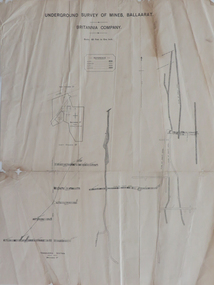
Plan, Underground Survey of Mines, Ballaarat, Britannia Company, not dated
Printed underground survey of the Britannia Companyunderground survey, britannia company, last chance company, transverse section -
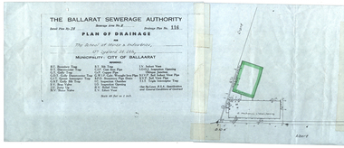 Federation University Historical Collection
Plan, Ballarat School of Mines Plan of Drainage, 1980?
Photocopied Sewerage Plan for Albert Street Scale 1: 480ballarat school of mines, ballarat sewerage authority, museum, welding shop, machine shop, ballarat junior technical school, plumbing -
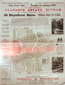 Eltham District Historical Society Inc
Negative - Photograph, Coghill & Haughton, Stanhope Estate, Eltham; great suburban subdivisional auction, New Year's Day - Tuesday 1st January 1924, 1923
Subdivision of Stanhope property into 80 blocks; auction sale 1 Jan 1924 Roll of 35mm colour negative film, 3 stripsKodak CL 200 5093butcher, coghill and haughton, eltham, eltham railway station, railway station, real estate agent, stanhope estate, stanhope house -
 Kew Historical Society Inc
Plan - Subdivision Plan, J R Mathers & McMillan, Glenferrie Road, Cotham Road, Belmont Avenue, Stirling Street, 1910-1930
Pru Sanderson, in her groundbreaking ‘City of Kew Urban Conservation Study : Volume 2 - Development History’ (1988), summarised the periods of urban development and subdivisions of land in Kew. The periods that she identified included 1845-1880, 1880-1893, 1893-1921, 1921-1933, 1933-1943, and Post-War Development. These periods were selected as they represented periods of rapid growth or decline in urban development. An obvious starting point for Sanderson’s groupings involved population growth and the associated economic cycles. These cycles also highlighted urban expansion onto land that was predominantly rural, although in other cases it represented the decline and breakup of large estates. A number of the plans in the Kew Historical Society’s collection can also be found in other collections, such as those of the State Library of Victoria and the Boroondara Library Service. A number are however unique to the collection.The Kew Historical Society collection includes almost 100 subdivision plans pertaining to suburbs of the City of Melbourne. Most of these are of Kew, Kew East or Studley Park, although a smaller number are plans of Camberwell, Deepdene, Balwyn and Hawthorn. It is believed that the majority of the plans were gifted to the Society by persons connected with the real estate firm - J. R. Mathers and McMillan, 136 Cotham Road, Kew. The Plans in the collection are rarely in pristine form, being working plans on which the agent would write notes and record lots sold and the prices of these. The subdivision plans are historically significant examples of the growth of urban Melbourne from the beginning of the 20th Century up until the 1980s. A number of the plans are double-sided and often include a photograph on the reverse. A number of the latter are by noted photographers such as J.E. Barnes.A ‘proposed’ subdivision of the area in the vicinity of Cotham and Glenferrie Roads and Belmont Avenue depicts an alternate vision for how the land might be divided into lots. When comparing this undated proposed subdivision with a modern map, it is possible to see why the subdivision did not eventuate. The right-of-way shown in the plan as beginning in Belmont Avenue was to be extended much further, preventing the lower lots from being created in the proposed shapes. Identifying the date of the name change may assist in the dating of the proposed subdivision. In faded writing at the top of the plan is an annotation referring to ‘Abbotsford’ and Finlayson’s Agency.subdivision plans - kew, glenferrie road, cotham road, belmont avenue, stirling street -
 Kew Historical Society Inc
Plan - Subdivision Plan, Flower Farm Estate, East Kew, 1922
Pru Sanderson, in her groundbreaking ‘City of Kew Urban Conservation Study : Volume 2 - Development History’ (1988), summarised the periods of urban development and subdivisions of land in Kew. The periods that she identified included 1845-1880, 1880-1893, 1893-1921, 1921-1933, 1933-1943, and Post-War Development. These periods were selected as they represented periods of rapid growth or decline in urban development. An obvious starting point for Sanderson’s groupings involved population growth and the associated economic cycles. These cycles also highlighted urban expansion onto land that was predominantly rural, although in other cases it represented the decline and breakup of large estates. A number of the plans in the Kew Historical Society’s collection can also be found in other collections, such as those of the State Library of Victoria and the Boroondara Library Service. A number are however unique to the collection.The Kew Historical Society collection includes almost 100 subdivision plans pertaining to suburbs of the City of Melbourne. Most of these are of Kew, Kew East or Studley Park, although a smaller number are plans of Camberwell, Deepdene, Balwyn and Hawthorn. It is believed that the majority of the plans were gifted to the Society by persons connected with the real estate firm - J. R. Mathers and McMillan, 136 Cotham Road, Kew. The Plans in the collection are rarely in pristine form, being working plans on which the agent would write notes and record lots sold and the prices of these. The subdivision plans are historically significant examples of the growth of urban Melbourne from the beginning of the 20th Century up until the 1980s. A number of the plans are double-sided and often include a photograph on the reverse. The subdivision called the ‘Flower Farm Estate’ in Kew East occurred in 1922. It included 61 lots on either side of Boorool Road between High Street and Harp Road. In an advertisement in The Argus in the same year, the proximity of the estate to the newly erected shops at the corner of Harp Road and High Street is noted. The Flower Farm Estate and similar subdivisions in Kew East were assisted by the extension of the High Street tramline in 1924.subdivision plans - east kew, flower farm estate, high street - kew east (vic.), boorool road -- kew east (vic.), harp road -- kew east (vic.) -
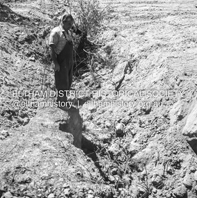 Eltham District Historical Society Inc
Negative - Photograph, J.A. McDonald, Buttermans Track, St Andrews, April 1962
Looking downstream from culvert to Fillia (?) property Circa April 1962Record of various Shire of Eltham infrastructure works undertaken during the period of 1952-1962 involving bridge and road reconstruction projects, sometimes with Eltham Shire Council Project Reference numbers quoted. It was during this period that a number of significant improvements were made to roads and new bridges constructed within the shire that remain in place as of present day (2022). In many situations, the photos provide a tangible visible record of infrastructure that existed throughout the early days of the Shire. The album was put together by or under the direction of the Shire Engineer, J.A. McDonald.1962-04, buttermans track, infrastructure, shire of eltham, st andrews, bridge construction -
 Ballarat Tramway Museum
Negative, Wal Jack, late 1950's?
Yields information about a possible variation of the end of section signs that was not adopted.Negative and Digital images of the Wal Jack Ballarat Negative file of tram stop sign in Wendouree Parade with a "Cars Stop Here", two End of Section signs. The vertical End of Section sign is different to all others seen. Haddon St? Has the Lake in the background. trams, tramways, tram stops, signs, end of section sign, wendouree parade, lake wendouree -
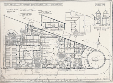 Mission to Seafarers Victoria
Plan - Architectural drawings, Walter Butler, New Missions to Seamen Institute Buildings Melbourne, 1916
In August 1916, Walter R. Butler presented the plans for the future central Seamen's Institute.The drawings show the original plans with rooms' names and intended use. They also show the original concept for the chapel which was in the Spanish Mission style.Plan copied from the 1983 Howden and Wardrop A4 report. A large plan on tracing paper (original or copy of the original) is held in the MSTV archives.flinders street, mission to seamen, mission to seafarers, walter richmond butler (1864–1949), norla dome, st peter chapel, spanish mission, arts and crafts, 1916 -
University of Melbourne, Burnley Campus Archives
Plan, Noel O'Keefe, Perennial Border Spring Display, 1994
Drawing No 1 by Noel O'Keefe. 15.07.1994. (Also see 11.0602).noel o'keefe, perennial -
Glenelg Shire Council Cultural Collection
Negative - Negative - Portland Bird Sanctuary, 1934
Negative for a black and white photograph. Portland Bird Sanctuary. Wooden post and rail fence in water. Seagulls, cormorants, sitting on it, swans in water behindzillah maschmedt, portland bird sanctuary, wildlife -
Glenelg Shire Council Cultural Collection
Negative - Negative - Nun's Beach, Portland, c. 1934
Negative for black and white photograph. Nun's Beach. Walkway to baths in foreground, camels sitting on beach. Whaler's Bluff with lighthouse and water tower in backgroundnegative, zillah maschmedt, nuns beach, portland, camels -
Glenelg Shire Council Cultural Collection
Plan - Plans / Line Drawings - Port of Portland Authority Slipway Tug Buccaneer, Victoria, 30/09/1989
Port of Portland Authority -
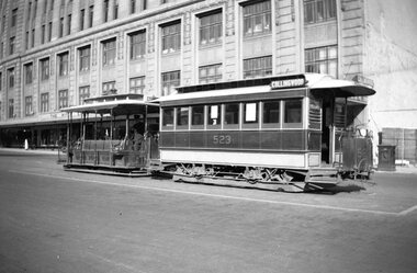 Melbourne Tram Museum
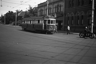
Negative, Wal Jack collection, Sep. 1939
Negative of a photograph of a cable car set at the Lonsdale St terminus, 9/1939, trailer 523. Tram has the destination of Collingwood. In the background is the Myer store - The Myer Emporium.trams, tramways, cable trams, lonsdale st, tram 523 -
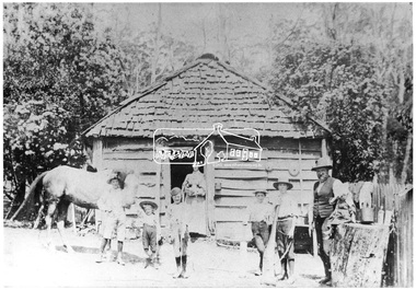 Eltham District Historical Society Inc
Negative - Photograph, Mr. Glower, Caretaker Cottage on Aitken's property
Reproduced on p42 of 'Pioneers & Painters'This photo forms part of a collection of photographs gathered by the Shire of Eltham for their centenary project book,"Pioneers and Painters: 100 years of the Shire of Eltham" by Alan Marshall (1971). The collection of over 500 images is held in partnership between Eltham District Historical Society and Yarra Plenty Regional Library (Eltham Library) and is now formally known as the 'The Shire of Eltham Pioneers Photograph Collection.' It is significant in being the first community sourced collection representing the places and people of the Shire's first one hundred years.Digital image 4 x 5 inch B&W Neg B&W Print 19 x 25 cmsepp, shire of eltham pioneers photograph collection, kinglake, aitken, caretaker cottage, glower, pioneers and painters -
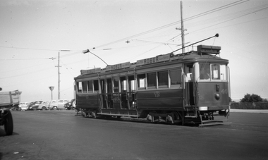 Melbourne Tram Museum
Negative, Wal Jack, c1951
Black and white negative, by Wal Jack, of VR 40 at the Brighton Beach terminus. Tram has the destination of St Kilda Rly (Railway Station) and two Robur Tea/Coffee adverts on the roof.trams, tramways, brighton beach, vr trams, st kilda brighton, tram 40 -
 Ballarat Tramway Museum
Negative, Geoff Grant, 7/05/1955 12:00:00 AM
Negative No. 283 and colour print made by colour laser printer (stored in folder ) of Y 613 leaving the Batman Avenue terminus 7/5/1955. Photo by Geoff Grant. Hi res scan of negative and image updated 19/5/2020.trams, tramways, melbourne, batman ave, tram y 613 -
University of Melbourne, Burnley Campus Archives
Negative - Colour negatives, Plant Materials
8 rolls negativesLabelled, "Diploma/Degree Semester 2 Weeks 6-13." "Weeds, Australian Plants, Climbing Plants & Ground Covers, Early Spring Flowering Plants, Californian Plants & Others, Plants for De Oxygenated Soils, Aquatic Plants, Botanical Gardens (Rarer Plants)." Not digitised.plant materials, weeds, australian plants, climbing plants, ground covers, early spring flowering plants, californian plants, deoxygenated soils, aquatic plants, botanical gardens, rare plants, degree, diploma -
 Eltham District Historical Society Inc
Negative - Photograph, Shire of Eltham, Eltham Meadows Estate, Zig Zag Road subdivision, Jan. 1980
eltham, eltham meadows estate, k.g. mcgorlick pty ltd, mcgorlick real estate, zig zag road subdivision -
 Melbourne Tram Museum
Negative - Set of 2, Wal Jack, 19/01/1941 12:00:00 AM
Set of two Black and white negatives by Wal Jack of SW2 432 (City Route 74) arriving Camberwell Junction in Camberwell Road. Photo dated 19-1-1941 Has the ES&A bank in the background.trams, tramways, camberwell junction, camberwell road, sw2 class, route 74, tram 432 -
Clunes Museum
Negative
Negatives on celluloid; .1 Clunes Cricket Club 1956-1957 .2 Clunes Cricket Club 1957-1958 .3 Clunes Cricket Club 1967-1968 .4 Clunes Cricket Club 1952-1953 .5 Clunes Football Club 1953 .6 Clunes Cricket Club 1963-1964 .7 Clunes Football Club 1967 .8 Clunes Football Club 1958 .9 Paper envelope (yellow).9 Handwritten in pencil "Negatives" Clunes Cricket club 1963-64, 52-53, 56-57 Clunes Football clube 1953, 1958 1951," Donated by Glenda Caboneclunes cricket club, clunes football club -
University of Melbourne, Burnley Campus Archives
Plan, Grace Park Feature Plan, 1901-1983
(1) City of Hawthorn plan dated August 1983. Drawing No P12/24 Sheet 1 of 1. Surveyed: L.B. & H.K. Traced H.K. Scale 1:500. (2) Photocopy of map of area, Grace Park coloured in. 1901 handwritten on page.hawthorn, grace park