Showing 1654 items in the category Documentation with item type Plan
-
 Federation University Historical Collection
Plan - Plans, University of Ballarat Plans for the Library Refurbishment creating the Geoffrey Blainey Research Centre at Mount Helen Campus, 2009, 11/2009
The E.J. Barker Library on the University of Ballarat (now federation University) campus was refurbished in 2009. Six A3 plans by Demaine of the Reading room and storage facility of the Geoffrey Blainey Research Centre.university of ballarat, geoffrey blainey research centre, demaine, refurbishment, library, mt helen library, e.j. barker library, library plan, mt helen library plan, gbrc -
 Bendigo Military Museum
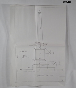
Plan - MONUMENT PLANS, C.1992
Plan for Monument in front of the Soldiers Memorial Institute Pall Mall Bendigo, refer Cat No 8245.2.Plan, white paper, all black ink of a proposed Monument, scale 1:100 showing front elevation, plan and section A.A"Proposed Monument to Ex Servicemen and Women to be erected in Pall Mall Bendigo"brsl, smirsl, monument, plan -
 Ringwood and District Historical Society
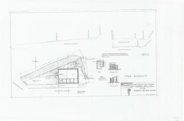
Plan, Drill Hall Site - Design for Military Units and Miniature Rifle Range, Ringwood, Victoria - Circa 1935
Technical drawings (a) Block Plan - Ringwood Drill Hall Site, Station Street, Ringwood. (b) Plan View, End and Side Elevation, Drill Hall Wodonga - Removed to Ringwood. (c) Plan View, Front and Rear Elevations, Minature Rifle Range at Ringwood Drill Hall.Commonwealth of Australia. Department of The Interior, Works & Services Branch, Victoria. -
Federation University Historical Collection
Plan, New Engineering Building for Ballarat School of Mines, 1939, 13/06/1939
.1) West and South Elevations .2) East and North Elecation and floor plan .3) Sections E-F, M-N, O-P, G-H, Z (Excavations and retaining walls) .4) Site plan and details of Retaining Walls .5) Excavations and retaining walls .6) Site Plan and retaining walls chief architect, ballarat school of mines, saw-tooth, engineering, architectural drawing -
Glenelg Shire Council Cultural Collection
Plan - Ships Plans/Moulds, n.d
Wooden pattern for mould for boat fitting. Half cylinder with rectangular section attached on angle, Smaller ½ cylinder each end. Holes on underside, to attach to other half of pattern piece. Painted brown, underside unpainted. -
University of Melbourne, Burnley Campus Archives
Plan, Yarra 500/045.043 Municipalities of Prahran 211 and Richmond 207, 1979
Melbourne and Metropolitan Board of Works Series 1:500. Map prepared by the Survey Division, MMBW January 1979. Scale 1:500. Area surrounding Heyington Station and St. Kevin's Junior Schoolmelbourne and metropolitan board of works, prahran, richmond -
 Falls Creek Historical Society
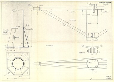
Plan - Diagram of Pylon for New Chairlift
Bob (Herman) Hymans (a former member of the Royal Netherlands Navy was born in Bloemendaal, Holland on 30th September 1922. During World War II he fought against the Japanese in the Dutch East Indies (now Indonesia) and was imprisoned in Changi and on the Burma Railway. After gaining qualifications as a Ski Instructor, Bob arrived in Falls Creek in May 1950. Working as an Instructor and Supervisor at Bogong Lodge, Bob decided his future was in accommodation. He was successful in negotiating an indenture for land from the State Electricity Commission (SEC). It took Bob two years to build his Grande Coeur Chalet but, tragically, it was burned down in August 1961. Bob also built the first Chairlift in Australia. This was a single chairlift and the structure was built from wooden electricity poles. He was constantly full of new ideas and proposals for the village. Bob Hymans died on 7th May 2007. This Collection of documents and letters tells the story of Bob’s endeavours to develop Falls Creek into the ski village it is today. This map is significant because it documents plans being proposed by Bob Hymans for Falls Creek.This diagram is part of Bob Hymans documents. It contains design drawings, measurements and cross sections for one of the pylons for a chairlift proposed by Bob Hymans. The design has been drawn up by Australasian Ropeways. It has been signed by Vladimir Hájek, a Czech engineer who Mr Hymans had consulted on several projects.Top right: AUSTRALASIAN ROPEWAYS with signature V. Hájek Bottom right: 204-01 PYLONmap of falls creek, falls creek leases, falls creek 1980s -
Port Melbourne Historical & Preservation Society
Plan - Williamstown Road, Derham Street to Raglan Street, Port Melbourne, 14 Mar 1893
Plan of Williamstown road from Derham street to Raglan street. (67.1), together with written specification of works attached. (67.2), 1893.A.V. Heath (Town Surveyor). J.J. Bartlett (Mayor).engineering - roads streets lanes and footpaths, arthur victor heath, town clerks, james john bartlett, mayors -
 Federation University Historical Collection
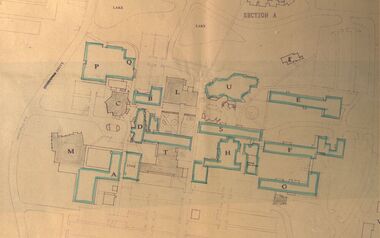
Plan - Site Plan, Mount Helen Campus Academic area
Federation University site plan made for the Ballarat College of Advanced Education Printed architectural plan of the Mount Helen campusprinted with location names and symbolssite plan, federation university, ballarat college of advanced education, mount helen campus, campus plan -
Port Melbourne Historical & Preservation Society
Plan - Port Melbourne Life Saving Club, Graeme Bentley Landscape Architects, Mar 1993
.01 - Plans and landscape drawings for Port Melbourne Life Saving Club, March 1993, 10pp .02 - One sheet "Landscape Master Plan" Port Melbourne Foreshorenatural environment - beaches and foreshore, built environment - recreational facilities, societies clubs unions and other organisations, graeme bentley - landscape architects -
University of Melbourne, Burnley Campus Archives
Plan, Henderson Residence, 1991
Landscape plans for a residence at 37 Auburn Road Hawthorn, Victoria by Patrick and Wallace Pty. Ltd. For Mr. and Mrs. N. Henderson. Drawn by RK February 1991. (1) Tracing paper and paper copies, Drawing No.9080/LD1, 'Hardworks Plan.' (2) Tracing paper copy, Drawing No. 9080/LD2 Hardworks Details.' (3) Tracing paper copy, Drawing No. 9080/3 'Planting Plann. henderson, patrick and wallace pty. ltd., hawthorn, planting plan, knot garden -
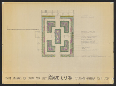 University of Melbourne, Burnley Campus Archives
Plan, Joanne Woodhead, Concept Drawing for Garden Week 1987 Potager Garden, 1986-1987
Drawn by Joanne Woodhead (Assoc. Dip. Hort.1986).joanne woodhead, potager garden, garden week 1987 -
Glen Eira Historical Society
Plan - Kooyong Road, 18, Caulfield North
Copies of correspondence, (5 pages) dated 8/07/1954 from valuer to Mr K W Blue concerning valuation of property at 18 Kooyong Road, Caulfield North. Correspondence provides property measurements, details of property, improvements and costings. In addition, the file also includes 2 pages of handwritten notes, undated and unattributed providing valuation details. Also included in the file is a hand-drawn property plan (150mm x 155mm) undated and unattributed. The plan may be of the property at 18 Kooyong Road ; the room measurements given by the plan correspond with the measurements for 18 Kooyong Road given by the correspondence. However, the plan has been labeled (in a biro pen) as 15 Kooyong Road, East St Kilda, though 18 has been written above the number 15.blue k w, a’beckett mrs, kooyong road, malonga court, caulfield, east st kilda, brick houses, land values, caulfield north -
Moorabbin Air Museum
Plan (Item) - Drawing Exterior Emergency Marking Lower Surface & STBD Side Orion P-3B Aircraft Drawing No. A16194 , Sheet 4 Of 5 Sheets
-
Port Melbourne Historical & Preservation Society
Plan - Multi-unit development, 164 Ingles Street, Port Melbourne, Site Plan 164 Ingles Street, 2015
Site plan for multi unit development. 164 Ingles St, Port Melbourne 2015-2016 A3 sheet black and white printing On the site of Symex, J KItchen &Sons factory sitebuilt environment - domestic, woodruff street development pty ltd, canny building pty ltd, j kitchen & sons pty ltd, symex holdings ltd -
Port Melbourne Historical & Preservation Society
Plan - Bridge over lagoon, Graham Street, Sandridge, Borough of Sandridge, 15 Oct 1878
Drawing of Graham Street bridge over the lagoon, 1878.Signed by E. Clark, Town Clerk, and Chas. Clay, Borough Surveyor.engineering - bridges, edward clark, town clerks, charles clay, graham street, sandridge lagoon -
Port Melbourne Historical & Preservation Society
Plan - Air raid shelter, Engineering Department, City of Port Melbourne, Shelter Type 'A', 7 Jan 1942
Plan for air raid shelter comprising 5'3" reinforced concrete pipe with seating - probably for schoolyard. January 1942.war - world war ii, built environment, city engineers, fred cook -
Port Melbourne Historical & Preservation Society
Plan - North west elevation, Port Melbourne Town Hall, Engineering Department, City of Port Melbourne, 1915
Plan of new (1915) Town Hall, Port Melbourne (proposal ?). North west elevation, longitudinal section, front elevation, cross section A-A, section B-B.port melbourne town hall -
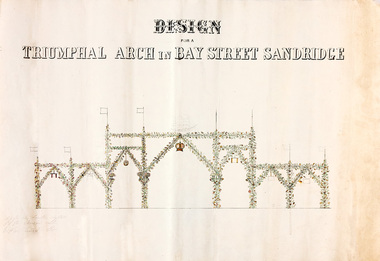 Port Melbourne Historical & Preservation Society
Plan - Triumphal Arch, Bay Street, Sandridge, Borough of Sandridge, 1867
Drawn for the Council Committee for reception of Prince Alfred Oct 1867Design for triumphal arches in Bay Street, Sandridge (with measurements for Fountain Inn, Bridge Street and Liardet Street locations) probably 1867 - visit of Prince AlfredMeasurements noted in pencil.royal visits and occasions, celebrations fetes and exhibitions, prince alfred, bay street -
Port Melbourne Historical & Preservation Society
Plan - Coal tramway, Town Pier to Gas Works via Esplanade West, 1880s
From set of three photocopies of two plans of coal tramway, Town Pier to Gas Works via Esplanade West: Plan of coal tramwaytransport - tramways, utilities - gas, sandridge lagoon, industry - manufacturing, piers and wharves - town pier, metropolitan gas company, australasia sugar refining company, robert harper & co ltd -
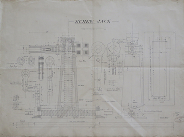 Federation University Historical Collection
Plan - Technical drawing, Hand drawn plan for screw jack, 1916
Ink on paper technical drawing for screw jack technical drawing, screw jack -
Moorabbin Air Museum
Plan (item) - Bristol Aeroplane 170 schematic drawings, Panel Additions for Auto Coarse Pitching
Bristol Aeroplane Company Ltd -
Port Melbourne Historical & Preservation Society
Plan - Drainage, 50 Beach Street, Port Melbourne, 18 Jan 1899
Photocopies (2) of black / white plan of drainage for Mr Warren, 50 Beach Street Port Melbournemmbw, melbourne and metropolitan board of works, f t warren -
Port Melbourne Historical & Preservation Society
Plan - Proposed footbridge over the Lagoon, Bridge Street, Port Melbourne, 1863
Plan of proposed footbridge over the Lagoon in line of Bridge StreetIn ink on reverse, two small drawings: elevation land view over a distance of 25.00 chains (colour tinted), and Plan view, section of an unidentified street:In pencil on reverse, notation '107 Albert Street'sandridge lagoon, robert h morgan -
University of Melbourne, Burnley Campus Archives
Plan, Horticultural & Experimental Garden in the Survey Paddock Richmond, 1862
Plan of site with area drawn in. From Office Dept. of Natural Resources.Handwritten on original: "To accompany letter from the Hon. Sec. of the Horticultural Society of Victoria to the Hon. The President of the Board of Land Works. A. Purchas, C.E. 9 October 1862 R 19 A1." and "Memo: The trees to be planted 50 feet apart in each row. AP"burnley, horticultural society of victoria -
Moorabbin Air Museum
Plan (item) - Bristol Aeroplane 170 schematic drawings, Throttle Control Lever Wheel (Complete) Outboard
Bristol Aeroplane Company Ltd -
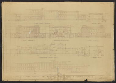 University of Melbourne, Burnley Campus Archives
Plan, New School of Primary Agriculture & Horticulture: Burnley Gardens, 1945
Original and photocopy of detailed architectural drawing and plan of new school by the Department of Public Works, Victoria Chief Architect, P. Everett.burnley school of horticulture, burnley gardens, percy everett -
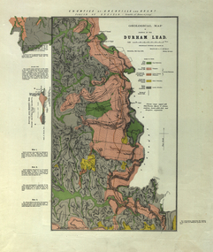 Federation University Historical Collection
Plan, Durham Lead, 1870
Geological Map of portions of Durham Lead. durham lead, reginald a.f. murray, plan, garibaldi, garibaldi company, geology, chryseis company, hardies hill, city of manchester company, williamson's creek, south grenville company, enfield company, pioneer company, duke of northumberland company, monmowth gully, extinct volcano crater, mount mercer basalt -
University of Melbourne, Burnley Campus Archives
Plan, Plan of the Zoological and Acclimatisation Society of Victoria, Royal Park, Melbourne, c. 1884
Copy of plan held at the State Library of Victoria surveyed by G. Purchas, possibly 1884. Possibly based on the winning competition entry by Alfred Lynch 1861 (See B17.0076). Also see B18.0030 Plan drawn by Caroline Le Souef.caroline le souef, alfred lynch, zoological and acclimatisation society of victoria, royal park, g. purchas -
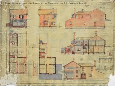 Whitehorse Historical Society Inc.
Plan - DVD, Mitcham Post Office Architect's Plans, 1923 (Digital Copy on DVD)
DVD containing scanned images of : Post office, shops and dwellings at Mitcham for P.J. Markham Esquire, plans and elevations - Sydney Smith, Ogg and Serpelt, Architects. Original document and preservation copy are held: see ND6466.markham, patrick joseph, mitcham post office