Showing 1648 items in the category Documentation with item type Plan
-
 Moorabbin Air Museum
Plan (item) - C.A.C Fighter Scale : 1/24th XP.67
-
 Federation University Historical Collection
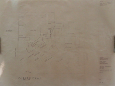
Plan, Ballarat School of Mines Schematic Proposal for the Former Ballarat Brewery Site
The Project Manager for the Ballarat School of Mines Brewery Building was Peter Davies. The plan suggests the closure of Lydiard Street South Copy of the Site plan for the Ballarat School of Mines Brewery Building, built on the site of the former Ballarat Brewery. The plan shows where the new building sites in relation to all other buildings at the Ballarat School of Mines ballarat school of mines, brewery building, ballarat brewery, architectural plans, schematic proposal, smb campus, former ballarat gaol, chimney tower, m.b. john building, lydiard street south, armstrong street south -
Glenelg Shire Council Cultural Collection
Plan - Ship Plan / Mould, n.d
Wooden pattern for mould for boat fitting. Boomerang shaped flat base, strip of ply wood attached at right angles to base, with copper nails, shaped block attached to underside of base with copper nails. Top painted cream, underside unpainted. -
Port Melbourne Historical & Preservation Society
Plan - Metalling and channelling Liardet Street from Esplanade East to Esplanade West, 14 Mar 1893
Specifications (102.1) & Plan (102.2) for metalling and channelling Liardet Street from Esplanade East to Esplanade West 1893..Both signed by J.J. Bartlett. (Mayor).engineering - roads streets lanes and footpaths, town planning, town clerks, mayors, arthur victor heath, james john bartlett -
University of Melbourne, Burnley Campus Archives
Plan, Richmond, 2001
Handdrawn plan of Burnley Campus and the surrounding Richmond area. Probably drawn by a student for Burnley Student Association. Found in former Staff Room 2012."Merryl 2001"burnley campus, richmond -
Glenelg Shire Council Cultural Collection
Plan - Plans / Line Drawings - Port of Portland Authority Slipway, Bilge Blocks Steel Fishing Vessel, Victoria, 26/08/1987
Port of Portland AuthorityFront: '44' - black texta, top right corner -
 Kew Historical Society Inc
Plan - Subdivision Plan, Jas R Mathers Son & McMillan, East Kew Tramway Estate, 1915
Pru Sanderson, in her groundbreaking ‘City of Kew Urban Conservation Study : Volume 2 - Development History’ (1988), summarised the periods of urban development and subdivisions of land in Kew. The periods that she identified included 1845-1880, 1880-1893, 1893-1921, 1921-1933, 1933-1943, and Post-War Development. These periods were selected as they represented periods of rapid growth or decline in urban development. An obvious starting point for Sanderson’s groupings involved population growth and the associated economic cycles. These cycles also highlighted urban expansion onto land that was predominantly rural, although in other cases it represented the decline and breakup of large estates. A number of the plans in the Kew Historical Society’s collection can also be found in other collections, such as those of the State Library of Victoria and the Boroondara Library Service. A number are however unique to the collection.The Kew Historical Society collection includes almost 100 subdivision plans pertaining to suburbs of the City of Melbourne. Most of these are of Kew, Kew East or Studley Park, although a smaller number are plans of Camberwell, Deepdene, Balwyn and Hawthorn. It is believed that the majority of the plans were gifted to the Society by persons connected with the real estate firm - J. R. Mathers and McMillan, 136 Cotham Road, Kew. The Plans in the collection are rarely in pristine form, being working plans on which the agent would write notes and record lots sold and the prices of these. The subdivision plans are historically significant examples of the growth of urban Melbourne from the beginning of the 20th Century up until the 1980s. A number of the plans are double-sided and often include a photograph on the reverse. A number of the latter are by noted photographers such as J.E. Barnes.The East Kew Tramway Estate was a subdivision of two separate parcels of land between Adeney Avenue and Normanby Road. The larger section included 54 lots facing Adeney Avenue, Argyle Road, and Campbell, Hunter and Wishart Streets. [Hunter and Wishart Streets were created as part of the subdivision.] A further 17 allotments faced Normanby Road, Hubert and Campbell Streets. [The name of Hubert Street was later to be changed to Cecil Street.] The promotion of the sale referred to the advantages of living between two tram routes, in High Street and Cotham Road. On the plan, quaintly drawn trams mark these routes. Also on the plan is the route of part of the Outer Circle [Railway] Line.east kew tramway estate, subdivision plans - east kew -
 Kew Historical Society Inc
Plan - Subdivision Plan, Harvest Home Estate, 1919
Pru Sanderson, in her groundbreaking ‘City of Kew Urban Conservation Study : Volume 2 - Development History’ (1988), summarised the periods of urban development and subdivisions of land in Kew. The periods that she identified included 1845-1880, 1880-1893, 1893-1921, 1921-1933, 1933-1943, and Post-War Development. These periods were selected as they represented periods of rapid growth or decline in urban development. An obvious starting point for Sanderson’s groupings involved population growth and the associated economic cycles. These cycles also highlighted urban expansion onto land that was predominantly rural, although in other cases it represented the decline and breakup of large estates. A number of the plans in the Kew Historical Society’s collection can also be found in other collections, such as those of the State Library of Victoria and the Boroondara Library Service. A number are however unique to the collection.The Kew Historical Society collection includes almost 100 subdivision plans pertaining to suburbs of the City of Melbourne. Most of these are of Kew, Kew East or Studley Park, although a smaller number are plans of Camberwell, Deepdene, Balwyn and Hawthorn. It is believed that the majority of the plans were gifted to the Society by persons connected with the real estate firm - J. R. Mathers and McMillan, 136 Cotham Road, Kew. The Plans in the collection are rarely in pristine form, being working plans on which the agent would write notes and record lots sold and the prices of these. The subdivision plans are historically significant examples of the growth of urban Melbourne from the beginning of the 20th Century up until the 1980s. A number of the plans are double-sided and often include a photograph on the reverse. A number of the latter are by noted photographers such as J.E. Barnes.The ‘Harvest Home Estate’ was advertised as being a subdivision in East Kew. Now, Campbell and Owen Streets on which the allotments were located are classed as being in Kew. The Estate included 11 residential allotments abutting the Outer Circle Railway line [at the end of Owen Street]. Understandably, the vendors focused on the availability of transport by tram, noting that the Estate was near the High Street tram terminus at the Harp of Erin. A small note on the subdivision advises that the Cotham Road tram was only 3 minutes away. The location – ‘The most elevated position in lovely Kew’ – was also promoted as an advantage.subdivision plans - east kew, harvest home estate -
 Bendigo Historical Society Inc.
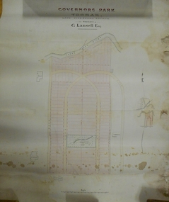
Plan - MARKS COLLECTION: PLAN OF G. LANSELL'S GOVERNOR'S PARK, TOORAK
Plan (tightly rolled) drawn on heavy paper mounted on fabric. On top of plan printed 'Governor's Park Toorak, late Vice-Regal Estate, the property of G. Lansell Esq' On top of plan Yarra River, on bottom Toorak Road, Plan shows subdivision, in centre of which is drawn outline of 8 acres containing the 'Mansion and Grounds'.bendigo, hospital -
Port Melbourne Historical & Preservation Society
Plan - Pathworks, Heath Street, Port Melbourne, Borough of Sandridge, 16 Feb 1861
Plan - Pathworks Heath StreetFrederick Wm. Bull Municipal Surveyor Sandridgeengineering - roads streets lanes and footpaths, frederick william bull -
Glenelg Shire Council Cultural Collection
Plan - Impression of the ultimate development of the Port of Portland, Ultimate Development of the Port of Portland, c. 1960
Donor's father was Shire Secretary at Hawkesdale and attended the opening of the Port.Impression of the ultimate development of the Port of Portland. Colour image on heavy, shiny white paper, white border round image. Folded in half.Front: 'Impression of Ultimate Development of the Port of Portland' - Printed in black, beneath colour image.port of portland -
Glenelg Shire Council Cultural Collection
Plan - Plans - Port of Portland Slipway - Steel Trawler 'Aqua Enterprise', 02/10/1980
PORT OF PORTLAND AUTHORITYFront: '18' - black texta, top right corner -
Moorabbin Air Museum
Plan (item) - Bristol Aeroplane 170 schematic drawings, Panel Additions for Auto Coarse Pitching
Bristol Aeroplane Company Ltd -
 Bendigo Military Museum
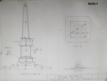
Plan - MONUMENT PLANS, C.1992
These plans were for a proposed Memorial to Ex Servicemen and Women to be erected in front of the Soldiers Memorial Institute in Pall Mall Bendigo. This building is now known as "The Bendigo Military Museum".1) .2) Two Cronaflex .004 thick black ink plans , scale 1 - 100showing front elevation and plan of a proposed Monument. Both plans are slightly different showing plan sections."Proposed Monument to Ex Servicemen and Women to be erected in Pall Mall Bendigo"brsl, smirsl, monument, plan, -
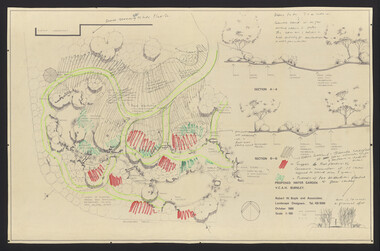
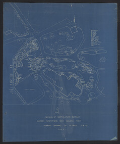
 University of Melbourne, Burnley Campus Archives
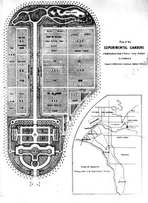
Plan, Plan of the Experimental Gardens of the Horticultural Society of Victoria. Survey Paddock. Richmond, c.1860-1862
Copy of Plan B92.0632 laminated for use in the Centenary Exhibition of 1991 at Burnley College.experimental gardens, horticultural society of victoria, plan -
University of Melbourne, Burnley Campus Archives
Plan, Ian Porter, Civic Square, 1994
Laminated, coloured , Preliminary Plan by Ian Porter dated 15.10.1994, No 3 of 3. Scale 1:200.civic square, ian porter -
 University of Melbourne, Burnley Campus Archives
Plan, Rainforest Garden Development VCAH Burnley, 1990-1992
Some of these plans were held in P. Tulk's office, used by Honours Student, Linda Hipwell in 1999. (1a) Rough sketch on tracing paper. (1) Rainforest Project drawn by G. Olive, rough sketch pen and pencil on paper. (2) 1 tracing paper and 2 paper copies, Rainforest Garden Development Plant Schedule Key by type of plant. (3) Blueprint of Rainforest Garden Development, plant names beside plants, note to P. Tulk from J. Kellow. (4) Native Garden Burnley VCAH Hort Eng. II. Surveying by Gail, John, Rebecca, Sean, Tim (Students). g. olive, phil tulk, linda hipwell, vcah, students, rainforest, gardens -
Moorabbin Air Museum
Plan (item) - Ram-Jet Helicopter No.1 Scale 1/24
-
Glenelg Shire Council Cultural Collection
Plan - Plan - Cantilever retaining walls, n.d
Port of Portland Authority Archives -
University of Melbourne, Burnley Campus Archives
Plan, Landscape Construction I Paving on Mortar, 1990-2000
Plan of paving construction. Fall to Grade. Scale 1:20.landscape construction, paving -
University of Melbourne, Burnley Campus Archives
Plan, Ratio Consultants Pty. Ltd, Conceptual Subdivision & Garden Layout Plan Project 'Rosecraddock' Rosecraddock Place Caulfield, 1991
Tracing paper plan by Ratio Consultants Pty. Ltd., for Mr P. Shellard, Project No 1887, drawing No LS3, October 1991. Scale 1:250.p. shellard, caulfield, ratio consultants, "rosecraddock", subdivision plans, landscape design -
Moorabbin Air Museum
Plan (Item) - Plan British Aerospace Hawk Ex GAF
-
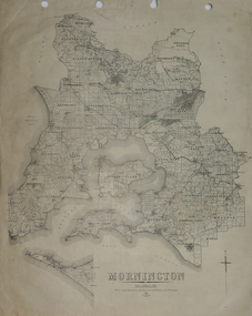 Federation University Historical Collection
Plan, Mornington, 1926, 1926
Printed plan on papermornington, phillip island, western port bay, bass straight, wonthaggi, lang lang, sherwood, nepean, narre worran, ringwood -
 University of Melbourne, Burnley Campus Archives
Plan, Water Garden & Grassy woodland, 1987-1995
(1) Water Garden V.C.A.H Burnley Irrigation Plan, drawn by M.D. 12.11.87. (2) Tracing paper copy, Proposed Pool Development Native Garden V.C.A.H. Burnley -Survey of approximate dimensions showing fall and depth of pools. Drawn by J.H.K. 9.9.88. (3) Rough coloured plan, Water Garden Planting Plan. (4) Proposed Water Garden V.C.A.H. Burnley by Robert W. Boyle and Associates October 1988, with handwritten annotations by James Hitchmough. (5) Coloured final version. (6) Tracing paper copy, Planting Scheme Native Garden VCAH Burnley. Design by James Hitchmough. Drawing J.K. 13.8.90. (7) Section Native Grassland Burnley Campus - Larger Tree Cover by Marika Kocsis & Martin Hopkins. Drawn by Leigh Stone 25.9.95. Survey Plan, no key to numbers. (8) Section Native Grassland by Marika Kocsis & Martin Hopkins. Drawn by Leigh Stone 20.9.95. No key to numbers. (9) Tracing paper copy Native Garden by Paul Eaves 6.9.90. Scale 1:100. Also 2 plant lists (11.0478/1 and /2). Also see 11.0478 List of plants. (11) Letter to P. Tulk from Robert Boyle dated 07.10.1988 "Re: Cost Estimates for Construction of Proposed Water Garden."water garden, vcah, robert w. boyle, james hitchmough, jill kellow, marika kocsis, martin hopkins, leigh stone, paul eaves -
 University of Melbourne, Burnley Campus Archives
Plan, Hilda Marriott ( Dance), Garden Plans by Hilda Marriott (Dance), 1947-1981
Set of 8 plans, including blue-prints, of various gardens, dated c. 1947 - 1981. See paper catalogue for complete list.Plans by Hilda Marriott Dance (1) Sketch plan and 2 blueprint copies of School of Horticulture Burnley. Garden Alterations New Building Area, Working Drawing by H. Dance, Scale ⅟₂₀"=1', 2/4/47, on reverse handwritten,"Proposed Garden Lay-out for New School Building (H. Dance-plan)." (NB Emily Gibson was also involved in the planning of this site.) (2) Tracing paper, paper and blueprint copies of Ararat & District Hospital Garden Plan - MacDonald Memorial & Court, Landscape Architect - H. Dance, Scale 1 inch=8 feet. Includes handwritten note, "Replacement for Ararat Hospital Nov. 1979," list of plants. (3) Blueprint Proposed Design for Garden Watermill Farm, Newbury for Norman Gadsden Esq., Scale ⅟₄₀"=1 ft. (4) Sketch Plan for Garden, Barcombe, Buangor - January 1981 by Hilda Marriott, Scale - Approximate Only - 1:40. (5) Tracing paper copy of plan of Garden at Plumhill, Templestowe, for Mr. & Mrs. Colin Smith. Hilda Dance, Designer 26/4/47, Scale ⅛"=1'. (6) Blueprint Garden House - Sketch. (7) Tracing paper and paper copies Ararat Medical Centre Courtyard Garden, Landscape Architect - Hilda Marriott, Scale - 1:25, Date 8.5.79. (8) Tracing paper copy National Trust of Australia (Victoria) The Heights, Newtown, Geelong Garden Plan, Scale 1:250, Drawn by - Hilda Marriott, Date 12.10.79.(1): on reverse handwritten,"Proposed Garden Lay-out for New School Building (H. Dance - plan)." (2): Includes handwritten note, "Replacement for Ararat Hospital Nov. 1979," list of plants.hilda marriott ( dance), burnley school of horticulture, students -
University of Melbourne, Burnley Campus Archives
Plan, Percy Everett, Sketch for Administration Office for the Egg-Laying Competition at the Burnley Horticultural Gardens, 1947
Architect's coloured drawing of proposed Administration Office for the Egg-laying Competition, by Percy Everett, Chief Architect dated 2.12.47. Not sure if ever executed but may have been in area sold off to Amrad/GEegg laying, competition, percy everett, burnley gardens -
Moorabbin Air Museum
Plan (Item) - Mirage III C Drawing , Markings MIR III C 092 F1
-
Glenelg Shire Council Cultural Collection
Plan - Ship Plan / Mould, n.d
Wooden pattern for mould for boat fitting. Rectangular, bottom corners rounded; 2 metal spikes on top edge, one each end; dark stain. -
University of Melbourne, Burnley Campus Archives
Plan - Planting Design, Gibson North Island Bed
emily gibson, plant list, garden plan -
Glenelg Shire Council Cultural Collection
Plan - Plans / Line Drawing - Port of Portland Slipway, Wooden Vessel 'Daniel', 21/08/1974
Front: '17' - black texta, top right cornerport of portland