Showing 1641 items
matching documentation
-
 University of Melbourne, Burnley Campus Archives
Plan, Landscape Construction Facility/Field Station Entry Development Proposal, 1997-1998
The same plan, coloured, drawn by Phil Tulk with different dates: 27.11.1997 and 18.05.1998.phil tulk, field station, landscape construction facility -
 Federation University Historical Collection
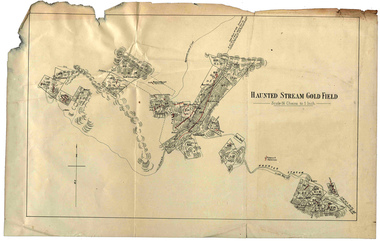
Plan, Haunted Stream Gold Field
Plan of the Haunted Stream Gold Field - scale 16 chains to 1 inchhaunted stream, plan, battery -
 Federation University Historical Collection
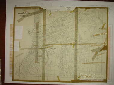
Plan, Ballarat East, 1916, 24/05/1916
Plan of streets and allotments in Ballarat East. Includes: Bakery Hill, Canadian Station, Eureka Cemetery, Orphan Asylum, Eureka Gardens and Reserve, Gun Clubballarat east, bakery hill, eureka stockade site, eureka gardens, ballarat orphanage -
 Bendigo Historical Society Inc.
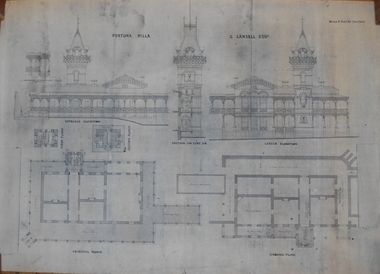
Plan - MARKS COLLECTION: PLAN OF FORTUNA VILLA
Copy of overall plan for Fortuna Villa. Plan shows entrance and garden elevations, ground plan and principal floor plan. Written on top of plan 'G Lansell Esq' 'Scale 8 feet to 1 inch'.bendigo, house, fortuna villa -
Moorabbin Air Museum
Plan (item) - Bristol Aeroplane 170 schematic drawings, Assy of Prop Controls ( De Havilland )
Bristol Aeroplane Company Ltd -
Port Melbourne Historical & Preservation Society
Plan - Fencng, Sandridge, Engineering Department, Borough of Sandridge, 1879
Design for fencing Block 19 (bounded by Lyons Street, Liardet Street and Esplanade West), Borough of Sandridge, 1879Signed by R Gabell (7-4-1879) and Chas. Clay, Surveyor (15-3-1879) and E. Clark, Town Clerk (14-4-1879):"Contract No. 355"engineering - fences, edward clark, town clerks, charles clay, r gabell -
Port Melbourne Historical & Preservation Society
Plan, J W Banks, Plans and Sections of Tramsway, Apr 1889
Large book of 9 pages, incl. title page, bound on left with black tape, wih plans and typeset descriptions of a proposal to run a cable tram under the Yarra from Williamstown to Melbourne (Falls Bridge) via Port Melbourne. Submitted to Victorian Legislative Assembly 1889Signed p. 2 by J.W. Banks, C.E.transport - tramways, town planning - proposals shelved, williamstown, j w banks -
Clunes Museum
Plan - PLANS CLUNES CARAVAN PARK, NO. 1 - SHIRE OF TALBOT & CLUNES. IAN MANSLEY, SHIRE ENGINEER NO. 2 - LEO MCMAHON & ASSOCIATES PTY. LTD. LICENSED SURVEYORS & ENGINEERS, 31 LYONS ST. NTH. BALLARAT, 1976
NO. 1 PLAN - CLUNES CARAVAN PARK ENGINEER - IAN MANLEY NO. 2 PLAN - SECTION 15 TOWNSHIP OF CLUNES, COUNTY OF TALBOT, BY LEO MCMAHON AND ASSOCIATES, LICENSED SURVEYORS AND CIVIL ENGINEERSplans, caravan park, ian manley, plan section 15 -
University of Melbourne, Burnley Campus Archives
Plan - Photocopy, Plan - Additions to Plant Research Laboratory (1) , Extension to Plant Research Laboratory for the Department of Agriculture, Burnley Gardens (2 & 3), 1953
University of Melbourne Property and Services has better copies Photocopies, reduced in size, of original plans. Signed by Dept of Public Works, Chief Architect. (1) and (2) dated 14.08.1953 (1) UCB.2.123 North Elevation, Perspective Sketch, Plan. (2) UCB.2.142₃ Floor plan. (3) UCB.2.157.0, dated 26.11.53, South Elevation Front (North) Elevation, West Elevation, Plan, Sections ₂. University of Melbourne - Property and Services has a better copy.plant research, laboratories -
Moorabbin Air Museum
Plan (item) - Bristol Aeroplane 170 schematic drawings, Replacement of Side Frame Tube Engine Nacelle Structure
Bristol Aeroplane Company Ltd -
University of Melbourne, Burnley Campus Archives
Plan, Alterations and Refurbishment of the Centen nial Display Building, 1990
Specification of workmanship and materials to be used in the construction of: Alterations and Refurbishment of the Centennial Display Building at Victorian College of Agriculture and Horticulture, Burnley for VCAH by Urban Spaces Pty. Ltd., Architects. Includes Plans and Elevations, and Presentation Drawings. Provenance Geoff C(?) 19.08.91. vcah, centennial -
Moorabbin Air Museum
Plan (item) - Bristol Aeroplane 170 schematic drawings, Additional Bolts at Top Boom Rear Spar
Bristol Aeroplane Company Ltd -
 Federation University Historical Collection
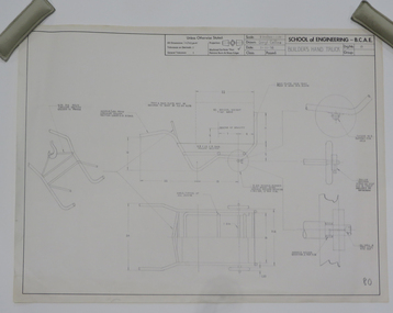
Plan - Student's Technical Drawing, Engineering drawing 'Builder's Hand Truck', 1976
Pencil on paper student's technical drawing ballarat school of mines, technical drawing, darryl collins, engineering -
Moorabbin Air Museum
Plan (item) - C.A.C Turbojet Trainer Rolls Royce Derwent X.P.60. P271
-
Moorabbin Air Museum
Plan (item) - Bristol Aeroplane 170 schematic drawings, Access Door Forward of Front Spar- Top Surface
Bristol Aeroplane Company Ltd -
 Kew Historical Society Inc
Plan, Melbourne & Metropolitan Board of Works : Borough of Kew : Detail Plan No.1291, 1905
The Melbourne and Metropolitan Board of Works (MMBW) plans were produced from the 1890s to the 1950s. They were crucial to the design and development of Melbourne's sewerage and drainage system. The plans, at a scale of 40 feet to 1 inch (1:480), provide a detailed historical record of Melbourne streetscapes and environmental features. Each plan covers one or two street blocks (roughly six streets), showing details of buildings, including garden layouts and ownership boundaries, and features such as laneways, drains, bridges, parks, municipal boundaries and other prominent landmarks as they existed at the time each plan was produced. (Source: State Library of Victoria). This plan forms part of a large group of MMBW plans and maps that was donated to the Society by the Mr Poulter, City Engineer of the City of Kew in 1989. Within this collection, thirty-five hand-coloured plans, backed with linen, are of statewide significance as they include annotations that provide details of construction materials used in buildings in the first decade of the 20th century as well as additional information about land ownership and usage. The copies in the Public Record Office Victoria and the State Library of Victoria are monochrome versions which do not denote building materials so that the maps in this collection are invaluable and unique tools for researchers and heritage consultants. A number of the plans are not held in the collection of the State Library of Victoria so they have the additional attribute of rarity.Original survey plan, issued by the MMBW to a contractor with responsibility for constructing sewers in the area identified on the plan within the Borough of Kew. The plan was at some stage hand-coloured, possibly by the contractor, but more likely by officers working in the Engineering Department of the Borough and later Town, then City of Kew. The hand-coloured sections of buildings on the plan were used to denote masonry or brick constructions (pink), weatherboard constructions (yellow), and public buildings (grey). A detail plan of part of Studley Park bordered by the major streets of Hodgson Street, Stevenson Street and Studley Park Road. Included on the plan are a number of significant Studley Park mansions in existence at the beginning of the 20th century. The unnamed street shown in the middle of the plan is McEvoy Street. The most important house still extant is Campion House, formerly named Dalsraith [Dalswraith] and Glendalough, owned since the 1940s by the Society of Jesus. Campion House can be seen on the corner of Hodgson and Studley Park Road. Its stables at the rear of the block have now been incorporated into a contemporary residence. An interesting feature of the plan is the 1910 annotation by Ed Seitz, professional designing engineer. Is Seitz the contractor who modified the MMBW original?melbourne and metropolitan board of works, detail plans, mmbw 1291, cartography -
Glenelg Shire Council Cultural Collection
Plan - Ship Plan / Mould, n.d
Wooden pattern for mould for boat fittings. Same as 6360 different size, painted gold -
University of Melbourne, Burnley Campus Archives
Plan, Nick Moore, Landscape Plan 12 Tyne Street Final Design Assignment, 2005
Coloured plan by Nick Moore dated June 2005. Scale 1:100.nick moore, landscape design -
 Wonga Park Community Cottage History Group
Plan (sub-item) - Plan re moving State School to corner of Yarra and Brysons Roads
A plan prepared by Mr. A.J. Upton (secretary and convenor of the Wonga Park School Committee) in about 1920, when residents were pressing for a new school to be located at the junction of Bryson’s and Yarra Road, the object being to combine the Wonga Park and Yarra Road Schools. Although the proposal was eventually dropped, this plan shows who lived in Wonga Park in the 1920’s and where they lived. [It is likely that this plan dates from some time after 1920.]wonga park school -
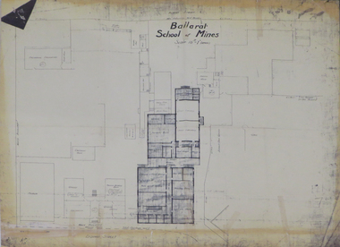 Federation University Historical Collection
Plan, Ballarat School of Mines 'Old Chemistry Building' Plan
Ballarat School of Mines is a predecessor institution of Federation University Australia. Two plans showing the Ballarat School of Mines Old chemistry Building and the Ballarat Technical Art School Building. It also shows the location of the Ballarat School of Mines Model Mine, Battery House, etc.ballarat school of mines, model mine, battery, old chemistry building, ballarat technical art school, laboratory, plan, architectural plans -
Port Melbourne Historical & Preservation Society
Plan - Soundings, Station Pier, Port Melbourne, Operation Division, Port of Melbourne Authority, Sep 1978
Plan: soundings taken at Station Pier, Port Melbourne: East and West Berths, 1978melbourne harbor trust - port of melbourne authority -
Glenelg Shire Council Cultural Collection
Plan - Line drawing - Port of Portland fishing vessel, n.d
port of portland -
Port Melbourne Historical & Preservation Society
Plan, A J Duncan, Draughtsman, Plans and Sections of Tramsway, May 1891
Plans and typeset descriptions of a proposal to run a cable tram under the Yarra from Williamstown to Melbourne (Falls Bridge) via Port Melbourne. Oriniginally submitted to Victorian Legislative Assembly 1889; this updated 1891 version has 10 pages, and includes an added section to take tramway to Sandridge Road as far as St. Kilda Road. A company has now formed to back the proposal being re-presented to the Legislative Assembly.Signed by Edward Clark 2-6-1891, with Borough stamp on cover; initialed, ditto, on page 2; signed by A.J. Duncan page 2.transport - tramways, town planning - proposals shelved, williamstown, edward clark, town clerks, mr jennings, austral - anglo tramway and general agency co ltd, a j duncan -
Port Melbourne Historical & Preservation Society
Plan - Water cart used in road construction, Borough of Sandridge, 21 Nov 1870
From a group of maps and plans not required by the Port Melbourne Council Engineering Department in May 1994 and offered at that time to the Port Melbourne Historical Society.Plan of water cart used in road construction including 4 diagrams and scales: signed by Borough Surveyor, Nov 21 1870.built environment - civic, engineering, engineering department - borough of sandridge -
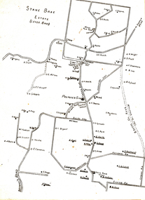
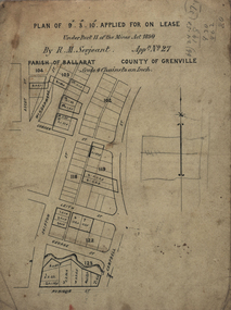 Federation University Historical Collection
Plan, Lease Applied for by R.M. Serjeant, c1890, c1890
Plan of a lease showing streets around Skipton and Windermere Streets, Redan. Scale 4 chains to 1 inch (!:3168)serjeant, r.m.serjeant, robert m. serjeant, george street, skiptn street, windermere stret, rubicon stret, cobdon street, ascot street, lease, redan, ballarat, robert malachi serjeant, band of hope and albion mine -
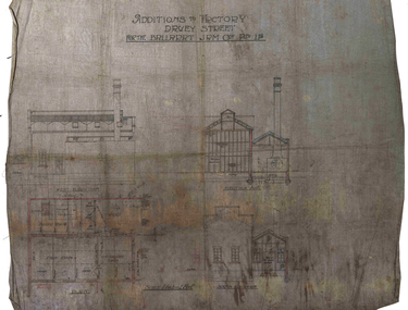 Federation University Historical Collection
Plan, Ballarat Jam Factory, Davey Street, not dated
Plan for the Ballarat Jam Factory, Davey StreetAdditions to Factory Davey Stret for the Ballarat Jam Coy Pty Ltdballarat jam factory, grigsby, industrial heritage, davey street -
University of Melbourne, Burnley Campus Archives
Plan, Road Diversions, 1881-1889
Sketch plan of Burnley College grounds showing road diversions in 1881 and 1889.burnley college -
Federation University Historical Collection
Plan, Ballarat Girls' Secondary School, Barkly Street, 1957
ballarat girls secondary school, ballarat east, barkly street -
Port Melbourne Historical & Preservation Society
Plan - Path, Bay Street and Crockford Street, Municipality of Sandridge, 8 Oct 1861
Path works, west side of Bay Street and Crockford Street (both sides) bearing Seal of Municipality of Sandridge.Frederick William Ball, Muncipal Surveyor: Kellyengineering - roads streets lanes and footpaths, local government - borough of sandridge, frederick william bull, kelly (surveyor) -
Port Melbourne Historical & Preservation Society
Plan - Evans Street from Ingles Street to Boundary Street, Engineering Department, Town of Port Melbourne, 1893 - 1919
Plan of Evans Street from Ingles Street to Boundary Street Loan no 5 1893.engineering - roads streets lanes and footpaths