Historical information
The Melbourne and Metropolitan Board of Works (MMBW) plans were produced from the 1890s to the 1950s. They were crucial to the design and development of Melbourne's sewerage and drainage system. The plans, at a scale of 40 feet to 1 inch (1:480), provide a detailed historical record of Melbourne streetscapes and environmental features. Each plan covers one or two street blocks (roughly six streets), showing details of buildings, including garden layouts and ownership boundaries, and features such as laneways, drains, bridges, parks, municipal boundaries and other prominent landmarks as they existed at the time each plan was produced. (Source: State Library of Victoria).
Significance
This plan forms part of a large group of MMBW plans and maps that was donated to the Society by the Mr Poulter, City Engineer of the City of Kew in 1989. Within this collection, thirty-five hand-coloured plans, backed with linen, are of statewide significance as they include annotations that provide details of construction materials used in buildings in the first decade of the 20th century as well as additional information about land ownership and usage. The copies in the Public Record Office Victoria and the State Library of Victoria are monochrome versions which do not denote building materials so that the maps in this collection are invaluable and unique tools for researchers and heritage consultants. A number of the plans are not held in the collection of the State Library of Victoria so they have the additional attribute of rarity.
Physical description
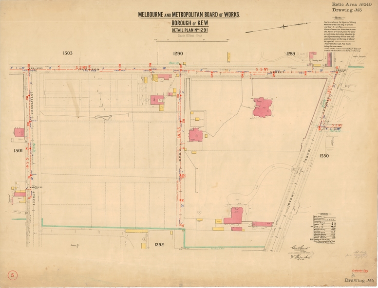
Original survey plan, issued by the MMBW to a contractor with responsibility for constructing sewers in the area identified on the plan within the Borough of Kew. The plan was at some stage hand-coloured, possibly by the contractor, but more likely by officers working in the Engineering Department of the Borough and later Town, then City of Kew. The hand-coloured sections of buildings on the plan were used to denote masonry or brick constructions (pink), weatherboard constructions (yellow), and public buildings (grey). A detail plan of part of Studley Park bordered by the major streets of Hodgson Street, Stevenson Street and Studley Park Road. Included on the plan are a number of significant Studley Park mansions in existence at the beginning of the 20th century. The unnamed street shown in the middle of the plan is McEvoy Street. The most important house still extant is Campion House, formerly named Dalsraith [Dalswraith] and Glendalough, owned since the 1940s by the Society of Jesus. Campion House can be seen on the corner of Hodgson and Studley Park Road. Its stables at the rear of the block have now been incorporated into a contemporary residence. An interesting feature of the plan is the 1910 annotation by Ed Seitz, professional designing engineer. Is Seitz the contractor who modified the MMBW original?