Showing 430 items matching "cartography"
-
 Sunshine and District Historical Society Incorporated
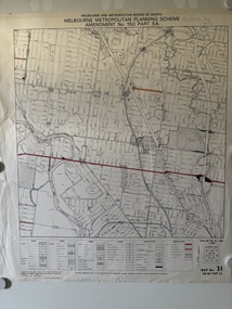
Map - Melbourne Metropolitan Planning Scheme Amendment No 31 Part 5A Map, Ford, Henry (Cartography)
... Ford, Henry (Cartography)...City of Sunshine Melbourne And Metropolitan Board Of Works Melbourne Metropolitan Planning Scheme Amendment No 31 Part 5A A map of parts of the municipalities of Brunswick, Coburg, and Essendon areas Map Melbourne Metropolitan Planning Scheme Amendment No 31 Part 5A Map Ford, Henry (Cartography) Ford, Henry ( Cartography) ...Melbourne And Metropolitan Board Of Works Melbourne Metropolitan Planning Scheme Amendment No 31 Part 5Acity of sunshine -
 Phillip Island and District Historical Society Inc.
Book, RMIT Cartography, Phillip Island : historical map series, 1991
... RMIT Cartography...Phillip Island : historical map series Book RMIT Cartography ...Stamped 'Phillip Island & District Historical Society'. -
 Sunshine and District Historical Society Incorporated
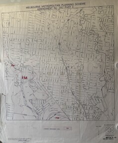
Map - Melbourne Metropolitan Planning Scheme Map No 282 Part 3, M.M.P.S (Melbourne Metropolitan Board of Works)
... Alonso, P. A. G (Cartography & Drafting)...City of Sunshine Lines showing Floodway Management Boundary A map of the Sunshine area, produced by the Sunshine Planning Committee Map Melbourne Metropolitan Planning Scheme Map No 282 Part 3 M.M.P.S (Melbourne Metropolitan Board of Works) Alonso, P. A. G (Cartography & Drafting) ...Lines showing Floodway Management Boundarycity of sunshine -
 Bendigo Military Museum
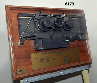
Plaque - Mounted Klimsch Commodore Cartographic Camera Lenses, WYCOMBE Constructions Pty Ltd, 1997
... These are the Lenses from the Klimsch Commodore Cartographic Camera that was located in Lithographic Squadron at the Army Survey Regiment, Fortuna, Bendigo. ...Lenses from the Klimsch Commodore Cartographic Camera mounted on a very heavy timber display board. ..."KLIMSCH COMMODORE CARTOGRAPHIC CAMERA 1977 - 1997", "FUNCTION: Precision Darkroom Camera especially suited for Cartographic Reproduction of Line, Continous Tone, Halftone and Colour Separation. ...THIS KLIMSCH COMMODORE CARTOGRAPHIC CAMERA was in operation 1977 - 1997". ...These are the Lenses from the Klimsch Commodore Cartographic Camera that was located in Lithographic Squadron at the Army Survey Regiment, Fortuna, Bendigo. The KLIMSCH Commodore camera was originally introduced to the Survey Regiment in 1953 and was the largest in the Southern Hemisphere. It was replaced with a new model of the same size in 1977. These lenses are from this new model. The new model with its computer-based interface provided productivity gains with improved speed and its consistent results led to less wastage in time and materials. Its variomat lens system provided improved retention of map feature linear weights during the camera reduction process. The camera which was specially made for the Australian Army in Germany was fully automatic and power operated. It was claimed to be one of the biggest automatic cameras of its type in the world. It was made to the specifications of the Royal Australian Army Survey Corps to assist in the production of the very high standard maps for the Australian Army. THIS KLIMSCH COMMODORE CARTOGRAPHIC CAMERA was in operation 1977 - 1997". It was a Precision Darkroom Camera especially suited for Cartographic Reproduction of Line, Continous Tone, Halftone and Colour Separation. Reproduction of Negatives and Positives from a variety of Reflection or Transmission Originals. Its characteristics were: Maximum Negative Size 1.27m sq, Copy Holder (Vacuum) 2m sq, Maximum Enlargement 400%, Maximum Reduction 13%, Automatic 60, 90 and 120cm Focal Length Lens, Transmission or Reflection Originals, Pulsed Xenon, Photo Flood or Fluorescent Tube Light Source, Maximum Reflection Original 1.3m x 1.85m, Maximum Transmission Original 1.3m x 1.85m, Exposure Light Monitoring System." The camera was superseded by computerized image manipulation software associated with the Automap system. These significant and extremely high-quality Lenses were retrieved by WYCOMBE Constructions Pty Ltd during the demolishment of the camera in 1997 and then mounted on a display board. See also Item 6189.4P for more photographs of the camera.Lenses from the Klimsch Commodore Cartographic Camera mounted on a very heavy timber display board. The display board contains an engraved plate that describes the technical characteristics of the camera."KLIMSCH COMMODORE CARTOGRAPHIC CAMERA 1977 - 1997", "FUNCTION: Precision Darkroom Camera especially suited for Cartographic Reproduction of Line, Continous Tone, Halftone and Colour Separation. Reproduction of Negatives and Positives from a variety of Reflection or Transmission Originals." "CHARACTERISTICS: Maximum Neg Size 1.27m sq, Copy Holder 2m sq, Maximum Enlargement 400%, Maximum Reduction 13%, Automatic 60, 90, 120cm Focal Length Lens, Transmission or Reflection Originals, Pulsed Xenon, Photo Flood or Fluorescent Tube Light Source, Maximum Reflection Original 1.3m x 1.85m, Maximum Transmission Original 1.3m x 1.85m, Exposure Light Monitoring System." royal australian survey corps, rasvy, fortuna, army survey regiment, army svy regt, asr, litho -
 Bendigo Military Museum
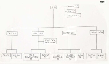
Administrative record - Army Survey Regiment - Cartographic Squadron Organisation Chart 1982, Army Survey Regiment, 1982
... .1 Army Survey Regiment - Organisation Schematic Diagram. .2 Organisation of Cartographic Squadron on 1 Mar 82. .3 Proposed Organisation/manning of Cartographic Squadron. .4 Cartographic Squadron.1 Mar 82. .5 Army Survey Regiment - Detachment Manpower Statistics. ...5 x Pages Manning Charts / Diagrams. 9187.1 Regimental Head Quarters - Planning Chart. 9187.2 Cartographic Squadron as of 1 March 1982. 9187.3 Proposed Organisation of Cartographic Squadron. 9187.4 Actual Manning Chart Cartographic Squadron 1 March 1982. 9187.5 Detachment Army Survey Regiment Manpower Statistics....1 Army Survey Regiment - Organisation Schematic Diagram. .2 Organisation of Cartographic Squadron on 1 Mar 82. .3 Proposed Organisation/manning of Cartographic Squadron. .4 Cartographic Squadron.1 Mar 82. .5 Army Survey Regiment - Detachment Manpower Statistics. ....1 Army Survey Regiment - Organisation Schematic Diagram. .2 Organisation of Cartographic Squadron on 1 Mar 82. .3 Proposed Organisation/manning of Cartographic Squadron. .4 Cartographic Squadron.1 Mar 82. .5 Army Survey Regiment - Detachment Manpower Statistics. Nov 81 - Oct 82.5 x Pages Manning Charts / Diagrams. 9187.1 Regimental Head Quarters - Planning Chart. 9187.2 Cartographic Squadron as of 1 March 1982. 9187.3 Proposed Organisation of Cartographic Squadron. 9187.4 Actual Manning Chart Cartographic Squadron 1 March 1982. 9187.5 Detachment Army Survey Regiment Manpower Statisticsregimental head quarters, cartographic squadron, army survey regiment, asr, army svy regt, fortuna -
 Bendigo Military Museum
Photograph - Scribing at the Army Survey Regiment, c1950s to 1979
... The photos were most likely taken in the Ballroom, Ante Room and Attic, Cartographic Squadron’s main production rooms on the top floor of Fortuna Villa. ...PTE BJ Madex. Cartographic Squadron...Cartographic Squadron Attic .5) - Photo, black & white, Oct 1961. ...These 10 photographs were taken over two decades from the late 1950s to 1979 at the Army Survey Regiment, Fortuna, Bendigo. The two photos taken in 1961 are annotated with named personnel and the date. The other photos are not annotated with dates, locations and names of personnel, although the technicians in the last three photos taken in 1979 are positively identified. The photos were most likely taken in the Ballroom, Ante Room and Attic, Cartographic Squadron’s main production rooms on the top floor of Fortuna Villa. Scribing was the cartographic process of drafting topographic features such as drainage, relief, vegetation, roads and culture on specially coated map reproduction material. The cartographic technician scribed out the map feature such as a creek to a specified line width on the map sheet, using a tool affixed with a metal or sapphire tipped cutter.This is a set of 10 photographs of technicians scribing topographic features at the Army Survey Regiment, Bendigo. The photographs were printed on photographic paper and are part of the Army Survey Regiment’s Collection. The photographs were scanned at 300 dpi. .1) - Photo, black & white, c1950s. unidentified personnel in Cartographic Squadron .2) - Photo, black & white, c1960s. unidentified personnel in Cartographic Squadron .3) - Photo, black & white, c1960s. unidentified personnel in Cartographic Squadron Attic .4) - Photo, black & white, c1960s. Cartographic Squadron Attic .5) - Photo, black & white, Oct 1961. L to R: PTE P. Carseldine, PTE H.S. Pasley, PTE C.A. Brown, WO2 M.A. McLaren, CPL Jennifer H. Murray. Cartographic Squadron .6) - Photo, black & white, Oct 1961. CPL Jennifer H. Murray. Cartographic Squadron .7) - Photo, black & white, 1979. SPR Mick Ellis in Cartographic Squadron .8) - Photo, black & white, 1979. SPR Mark Casey in Cartographic Squadron .9) - Photo, black & white, 1979. SPR Sharon (Jones) Treble in Cartographic Squadron .10) - Photo, black & white, 1961. PTE BJ Madex. Cartographic Squadron.1 to .4 - annotated “Scribing” .5 – annotated “Scribing PTE P. Carseldine, PTE H.S. Pasley, PTE C.A. Brown, WO2 M.A. McLaren, CPL Jennifer H. Murray. Oct 1961” .6 - annotated “Scribing CPL Jennifer H. Murray. Oct 1961” .7 to .9 - annotated “Scribing” .10 – annotated “PTE Madex Oct 61”royal australian survey corps, rasvy, army survey regiment, army svy regt, fortuna, asr, carto -
 Bendigo Military Museum
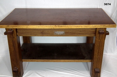
Furniture - TABLE, POW, c.1943 - 1944
... This table was made by Italian POW's at the Land HQ Cartographic Company for the Officers Mess, Fortuna, Bendigo in 1943-44....Plaque etched & attached to table: This Table Was Hand Made By The Italian Prisoners Of War Attached To The Land Headquarters Cartographic Company For The Officers Mess 1943 - 1944...Bendigo Military Museum 37 - 39 Pall Mall Bendigo goldfields This table was made by Italian POW's at the Land HQ Cartographic Company for the Officers Mess, Fortuna, Bendigo in 1943-44. ...This table was made by Italian POW's at the Land HQ Cartographic Company for the Officers Mess, Fortuna, Bendigo in 1943-44.Coffee table made from timber & masonite, has bottom shelf, all sections held together by wedge & groove, timber section has been varnished.Plaque etched & attached to table: This Table Was Hand Made By The Italian Prisoners Of War Attached To The Land Headquarters Cartographic Company For The Officers Mess 1943 - 1944army survey regiment, royal australian survey corps, rasvy, army svy regt, fortuna, asr -
 Bendigo Military Museum
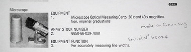
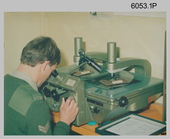
Instrument - Microscope Optical Measuring Cartographic, Hensoldt Wetzlar, Circa 1960
... A very accurate microscope for measuring cartographic line-weights (thickness) during the Mapping process. ...Silver alloy protecting Tube 5.5cms diameter and 12cms in height containing a Cartographic Microscope with imperial measurements. ...Microscope Optical Measuring Cartographic Instrument Microscope Optical Measuring Cartographic Hensoldt Wetzlar ...A very accurate microscope for measuring cartographic line-weights (thickness) during the Mapping process. Could be used to measure positive or negative line-weights or scribed lines in imperial measurements. Used at the Army Survey Regiment during the manual production of maps or charts.Silver alloy protecting Tube 5.5cms diameter and 12cms in height containing a Cartographic Microscope with imperial measurements. The Microscope is capable of 20 to 40 times magnification.Manufactured by "HENSOLDT WETZLAR" Serial Number 63024royal australian survey corps, rasvy, fortuna, army survey regiment, army svy regt, asr -
 Bendigo Military Museum
Photograph - Land Headquarters Cartographic Company - Group photograph Fortuna Villa, Bendigo Victoria, 1943
... This is a informal group photograph of soldiers serving at Land Headquarters Cartographic Company at Fortuna Villa, Bendigo, Victoria in 1943. ...This is an informal group photograph of personnel from Land Headquarters Cartographic Company - Fortuna Villa, Bendigo Victoria, 1943. ...This is a informal group photograph of soldiers serving at Land Headquarters Cartographic Company at Fortuna Villa, Bendigo, Victoria in 1943. ...This is a informal group photograph of soldiers serving at Land Headquarters Cartographic Company at Fortuna Villa, Bendigo, Victoria in 1943. VX85809 Charles Graham Kemp is named on the back of the photo 7th from the right. He enlisted in the Permanent Military Force in Bendigo, Victoria on the 02 Jun 1942. His previous occupation before enlistment was a commercial artist. In his 18 months of service years of service he was promoted twice, retiring at the rank of SGT from the AMF on 30 Nov 1943.This is an informal group photograph of personnel from Land Headquarters Cartographic Company - Fortuna Villa, Bendigo Victoria, 1943. The photograph was printed on photographic paper and is part of the Army Survey Regiment’s Collection. The photograph was scanned at 300 dpi. Photo, black & white, 1943 – Group photograph of Land Headquarters Cartographic Company personnel. Charles Graham Kemp is identified 7th from right.‘Charles Graham Kemp VX85809 Enlisted 2/06/1942. Discharged 30/11/1943. 7th from right.’ is annotated on back of the photoroyal australian survey corps, rasvy, fortuna, army survey regiment -
 Ballarat RSL Sub-Branch Inc.
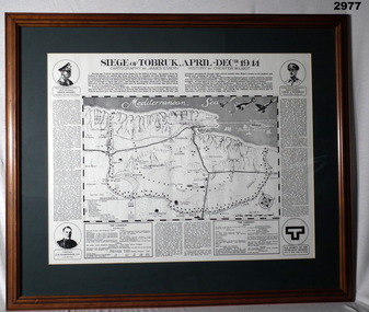
Picture - "Siege of Tobruk, April-Dec 1941"
... Cartography by James Emery; History by Chester Wilmot...Ballarat RSL Sub-Branch Inc. 330 Heinz Lane Invermay Park goldfields photo/pictures ballarat rsl ballarat Cartography by James Emery; History by Chester Wilmot Picture - "Siege of Tobruk, April-Dec 1941" ...Cartography by James Emery; History by Chester Wilmotphoto/pictures, ballarat rsl, ballarat -
 Bendigo Military Museum
Photograph - Retouching Reproduction Material at the Army Survey Regiment, c1960s, c1970s
... SGT Bob Scaddan appears in the fifth photo taken in the 1970s Photos .1P and .2P. could have been taken in Lithographic Squadron’s retouching room and Photos .3P, .4P and .5P. were probably taken in Cartographic Squadron’s Correcting Section, located in the Attic. ...SGT Bob Scaddan in Cartographic Squadron....The photographs were scanned at 300 dpi. .1) - Photo, black & white, c1960s. unidentified personnel in Lithographic Squadron. .2) - Photo, black & white, c1960s. unidentified personnel in Lithographic Squadron. .3) - Photo, black & white, c1960s. unidentified personnel in Cartographic Squadron Attic. .4) - Photo, black & white, c1960s. unidentified personnel in Cartographic Squadron Attic. .5) - Photo, black & white, c1970s. ...The first four photographs were most likely taken in the 1960 and the fifth in the 1970s at the Army Survey Regiment, Fortuna, Bendigo. As there are no annotations with the photos, the exact dates, locations and names of personnel are unknown. SGT Bob Scaddan appears in the fifth photo taken in the 1970s Photos .1P and .2P. could have been taken in Lithographic Squadron’s retouching room and Photos .3P, .4P and .5P. were probably taken in Cartographic Squadron’s Correcting Section, located in the Attic. Retouching mainly entailed the application of liquid opaque (Plumtree), commonly known as “duff” to cover blemishes such as scratches and spots on film negatives before photographic exposure. Retouching technicians also used specialised techniques such as “needling” to repair faults on the emulsion of map reproduction material. The technician in photo .4P is needling a hydrographic feature on a drainage negative, with a zoom transfer scope projecting a scaled projected aerial photograph as a positional reference. This is a set of five photographs of technicians retouching reproduction material at the Army Survey Regiment, Bendigo. The photographs were printed on photographic paper and are part of the Army Survey Regiment’s Collection. The photographs were scanned at 300 dpi. .1) - Photo, black & white, c1960s. unidentified personnel in Lithographic Squadron. .2) - Photo, black & white, c1960s. unidentified personnel in Lithographic Squadron. .3) - Photo, black & white, c1960s. unidentified personnel in Cartographic Squadron Attic. .4) - Photo, black & white, c1960s. unidentified personnel in Cartographic Squadron Attic. .5) - Photo, black & white, c1970s. SGT Bob Scaddan in Cartographic Squadron..1P to .3P, .5P - annotated “Retouching”royal australian survey corps, rasvy, army survey regiment, army svy regt, fortuna, asr, litho, carto -
 Kew RSL
framed print, Seige of Tobruk
... coloured print, cartography by James Emery & history by Chester Wilmott...Kew RSL 63 Cotham Rd Kew melbourne history of the Siege of Tobruk April to December 1941 tobruk, world war 2, maj gen leslie morshead, lt gen erwin romel, jh edmonson vc coloured print, cartography by James Emery & history by Chester Wilmott Seige of Tobruk framed print ...history of the Siege of Tobruk April to December 1941coloured print, cartography by James Emery & history by Chester Wilmotttobruk, world war 2, maj gen leslie morshead, lt gen erwin romel, jh edmonson vc -
 Bendigo Military Museum
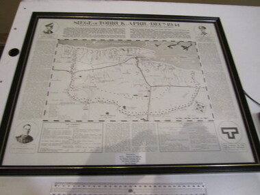
Map - MAP, FRAMED TOBRUK, Post WW2
... “Siege of Tobruk April - Decr 1941 Cartography By James Emery History By Chester Wilmot”...Bendigo Military Museum 37 - 39 Pall Mall Bendigo goldfields Framed maps tobruk Passchendaele barracks trust “Siege of Tobruk April - Decr 1941 Cartography By James Emery History By Chester Wilmot” Wooden framed, glass fronted, green bordered, black & white map with history. ...Wooden framed, glass fronted, green bordered, black & white map with history.“Siege of Tobruk April - Decr 1941 Cartography By James Emery History By Chester Wilmot”framed, maps, tobruk, passchendaele barracks trust -
 Bendigo Military Museum
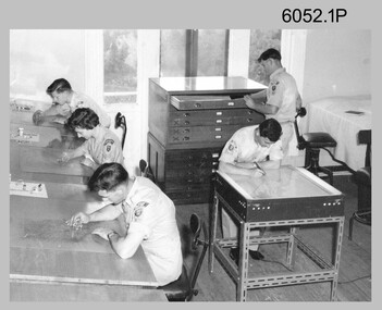
Photograph - Cartographic Squadron, Army Survey Regiment, Fortuna, Bendigo, c1985
... This is believed to be a photograph of Cartographic Squadron, one of the Army Survey Regiment’s squadrons at Fortuna, Bendigo. ...This is a photograph of Cartographic Squadron taken at the Army Survey Regiment, Fortuna, Bendigo. c1985. ...Bendigo Military Museum 37 - 39 Pall Mall Bendigo goldfields This is believed to be a photograph of Cartographic Squadron, one of the Army Survey Regiment’s squadrons at Fortuna, Bendigo. ...This is believed to be a photograph of Cartographic Squadron, one of the Army Survey Regiment’s squadrons at Fortuna, Bendigo. It was probably taken on Corps Day in July 1985 as its members appear in winter dress. Cartographic technician tasks undertaken by Cartographic Squadron at that time were scribing, compiling, retouching, masking, type setting, type stickup, terrain embossing, correcting and proving quality control. This is a photograph of Cartographic Squadron taken at the Army Survey Regiment, Fortuna, Bendigo. c1985. The black and white photograph was printed on photographic paper and is part of the Army Survey Regiment’s Collection. The photograph was scanned at 600 dpi. .1) - Photo, black & white, 1985, Cartographic Squadron, Army Survey Regiment. Back Row L to R: CPL Dave Cook, SPR John Keely, CPL Perry Burt, CPL Terry ‘TJ’ Wicker, CPL Roger Pearson, CPL Simon ‘Andy’ Capp, CPL Paul Richards, SPR Owen Jones, SPR Bjorn Sakariassen, CPL Graeme Priestley, SPR Roger Graf, SPR Robin Marshall, SGT Paul Hopes. Middle Row L to R: SPR Max Watson, CPL Doug Home, SGT Mick Flynn, SGT Alan Staley, CPL John Reid, SPR Denise (Muldoon) Marshall, CPL Mark Casey, SGT Greg Anderson, SPR Leah (Hoffman) Peppler, SPR Gayle Humphrey, CPL John ‘Stormy’ Tempest, SGT Paul Leskovec CSM, SGT Graeme Dowd, SPR Tracy (Parker) Ash. Front Row L to R: SGT John Zuringer, SSGT Adrian ‘Charlie’ Creedy, SSGT Dennis McCarthy, SSGT Ian ‘Rock’ Thistleton, SSGT Trevor Pearson, WO2 Russ Larsen, WO1 Doug Arman, MAJ Terry Edwards, WO1 Bill Griggs, WO1 Dick Manley, SSGT Tony Harder RE (UK Exchange), SSGT Doug Gay, SGT Tim Allanson, SGT Dennis Learmonth.No personnel are identified. royal australian survey corps, rasvy, army survey regiment, army svy regt, fortuna, carto, asr -
 Narre Warren and District Family History Group
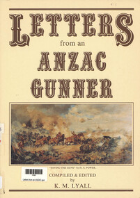
Book, Lyall's Yarns Pty Ltd, Letters from an ANZAC gunner, 1990
... xxiii, 214 p., [2] p. of plates : ill., cartographic materials, ports. ; 30 cm....Narre Warren and District Family History Group 110 High Street Berwick melbourne World War 1914-1918 Brian Lyall This book contains letters from an Anzac Gunner xxiii, 214 p., [2] p. of plates : ill., cartographic materials, ports. ; 30 cm. Letters from an ANZAC gunner Book Lyall's Yarns Pty Ltd Brian Lyall ...This book contains letters from an Anzac Gunnerxxiii, 214 p., [2] p. of plates : ill., cartographic materials, ports. ; 30 cm.non-fictionThis book contains letters from an Anzac Gunnerworld war 1914-1918, brian lyall -
 Bendigo Military Museum
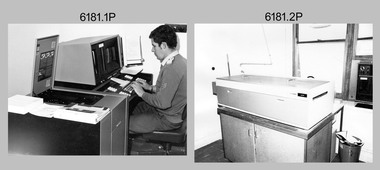
Photograph - Army Survey Regiment Map Production Equipment, c1980s, c1990s
... The resultant raster file was vectorized, feature coded with attributes and stored by cartographic technicians in the AUTOMAP 2 database. ...AUTOMAP 2 Graphic Edit Workstation, SPR Craig Kellet in Cartographic Squadron. .5) - Photo, colour, c1994. ...AUTOMAP 2 Graphic Edit Workstation, SPR Craig Kellet in Cartographic Squadron. .5) - Photo, colour, c1994. ...Photos .1P, .2P, and.4P were most likely taken in the 1980s and photos .3P, .5P to .8P in the c1990s at the Army Survey Regiment, Fortuna, Bendigo. Despite lacking annotation on exact dates, locations and personnel, they are positively identified. CPL Ian Nelson in photo .1P is operating a Wild Pug 4 point transfer device in Air Survey Squadron c1980s. Control points were transferred onto the mapping diapositives of aerial photography by drilling their locations into the photographic emulsion. SPR Viv (Hawkins) Doherty in photo .2P, SPR Jeanette Drury-Lane in photo .5P and SGT Sandy Craig are operating a Wild B8 Stereoplotter coupled to a digital workstation in Air Survey Squadron c1994. Topographic features were extracted with the B8 in 3D and feature coded with attributes, using keyboard, menu, keypad and voice inputs to the computer. The features were stored in the AUTOMAP 2 digital database for subsequent cartographic production and printing. CPL Mick Ellis in photo .3P is operating the Optronix 4040 Scanner/Film Writer in Lithographic Squadron c1990s. In scanning mode, compilation sheets were mounted on the drum and scanned. The resultant raster file was vectorized, feature coded with attributes and stored by cartographic technicians in the AUTOMAP 2 database. In film writing mode, digital cartographic files were output at very high resolution for each print colour on photosensitive film, for subsequent finalisation, platemaking and printing.This is a set of eight photographs of technicians operating map production equipment at the Army Survey Regiment, Bendigo. The photographs were printed on photographic paper and are part of the Army Survey Regiment’s Collection. The photographs were scanned at 300 dpi. Photo negatives were scanned at 2400 dpi. .1) - Photo, colour, c1980s. CPL Ian Nelson operating a Wild Pug 4 point transfer device in Air Survey Squadron. .2) - Photo, colour, c1980s. Wild B8 Aviograph stereoplotter feature extraction, SPR Viv (Hawkins) Doherty in Air Survey Squadron. .3) - Photo, colour, c1990s. CPL Mick Ellis operating the Optronics 4040 Scanner in Lithographic Squadron. .4) - Photo, colour, c1984. AUTOMAP 2 Graphic Edit Workstation, SPR Craig Kellet in Cartographic Squadron. .5) - Photo, colour, c1994. Wild B8 Aviograph stereoplotter feature extraction, SPR Jeanette Drury-Lane in Air Survey Squadron. .6) - Photo, colour, c1994. AUTOMAP 2 Graphic Edit Workstation, L to R: unidentified, SPR Rachel (Stanford) Scott, CPL Chris Wynn in Cartographic Squadron. .7) - Photo, colour, c1994. Wild B8 Aviograph stereoplotter AUTOMAP 2 Graphic Edit Workstation, L to R: unidentified (x2), SGT Sandy Craig in Air Survey Squadron. .8) - Photo, colour, c1994. AUTOMAP 2 Graphic Edit Workstation, L to R: unidentified, SPR Peter Smyth, SPR Frank Savy, SPR Quentin Seecamp, CPL Steve McGuiness in Cartographic Squadron. .1P – no annotations .2P – annotated “Stereoplotter Workstation. The operator has the use of keyboard, menu, keypad and voice for input to the computer. Feedback is given through voice and screen messages.” .3 to .8P – no annotationsroyal australian survey corps, rasvy, army survey regiment, army svy regt, fortuna, air survey, litho, aerotrig, automap 2 -
 Bendigo Historical Society Inc.
Document - BENDIGO CENTENARY COLLECTION: BOOKLET
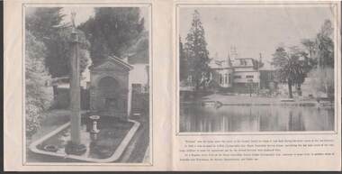
... Bendigo Centenary Celebrations booklet prepared by the AHQ Cartographic Company 'Fortuna' Oct 1951. Photograph of Fortuna and its grounds within....Bendigo Centenary Celebrations booklet prepared by the AHQ Cartographic Company 'Fortuna' Oct 1951. Photograph of Fortuna and its grounds within. ...Bendigo Centenary Celebrations booklet prepared by the AHQ Cartographic Company 'Fortuna' Oct 1951. Photograph of Fortuna and its grounds within.bendigo, history, fortuna and survey reg. -
 Williamstown Historical Society Inc
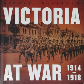
Book - Book - Victoria at War 1914 - 1918, Mckernan, Michael (1945, Victoria at war : 1914-1918 / Michael McKernan, 2014
... 230 pages : illustrations (some colour), portraits (some colour), colour maps ; 26 x 27 cm. cartographic image...Bestselling military historian Michael McKernan tells stories from the home front and battlefield that commemorates the generosity, devotion, sacrifice and spirit of a community pushed towards breaking point" -- from dust jacket. 230 pages : illustrations (some colour), portraits (some colour), colour maps ; 26 x 27 cm. cartographic image Victoria at war : 1914-1918 / Michael McKernan Book Book - Victoria at War 1914 - 1918 Mckernan, Michael (1945 - New South Publishing: University of New South Wales Press Ltd. ..."During the First World War, in Melbourne and communities throughout Victoria, schoolchildren knitted socks for the troops serving in Gallipoli, the Middle East and on the Western Front. Their families set up Red Cross branches to support the 91,000 Victorian servicemen and women overseas. Victoria at War records the achievements of the state's soldiers, nurses and their families - including the Whitelaws from Gippsland with six sons enlisting, 'Bert' Jacka, the first Australian to be awarded the Victoria Cross in the First World War, and commander Sir John Monash. By the end of the war 19,000 Victorian service people were dead and 42,000 wounded. Bestselling military historian Michael McKernan tells stories from the home front and battlefield that commemorates the generosity, devotion, sacrifice and spirit of a community pushed towards breaking point" -- from dust jacket.230 pages : illustrations (some colour), portraits (some colour), colour maps ; 26 x 27 cm. cartographic imagenon-fiction"During the First World War, in Melbourne and communities throughout Victoria, schoolchildren knitted socks for the troops serving in Gallipoli, the Middle East and on the Western Front. Their families set up Red Cross branches to support the 91,000 Victorian servicemen and women overseas. Victoria at War records the achievements of the state's soldiers, nurses and their families - including the Whitelaws from Gippsland with six sons enlisting, 'Bert' Jacka, the first Australian to be awarded the Victoria Cross in the First World War, and commander Sir John Monash. By the end of the war 19,000 Victorian service people were dead and 42,000 wounded. Bestselling military historian Michael McKernan tells stories from the home front and battlefield that commemorates the generosity, devotion, sacrifice and spirit of a community pushed towards breaking point" -- from dust jacket.world war 1, victoria at war -
Dandenong/Cranbourne RSL Sub Branch
Framed Print currents and surface winds for the west pacific area May- October. Reproduced by the RAAF Headquarters (Cartographic Section) OCT 1944 ___RESTRICTED
... Reproduced by the RAAF Headquarters (Cartographic Section) OCT 1944 ___RESTRICTED ...Reproduced by the RAAF Headquarters (Cartographic Section) OCT 1944 ___RESTRICTED ...Framed Print currents and surface winds for the west pacific area May- October. Reproduced by the RAAF Headquarters (Cartographic Section) OCT 1944 ___RESTRICTED -
 Bendigo Military Museum
Photograph - Personnel and Equipment, Army Survey Regiment, Fortuna, Bendigo. c1979, c1979
... This is a set of 23 photographs of cartographic, aero-triangulation and lithographic equipment, and personnel at the Army Survey Regiment, Fortuna, Bendigo circa 1979. ...This is a set of 23 photographs of cartographic, aero-triangulation and lithographic equipment, and personnel at the Army Survey Regiment, Fortuna, Bendigo, c1979. ...Bendigo Military Museum 37 - 39 Pall Mall Bendigo goldfields This is a set of 23 photographs of cartographic, aero-triangulation and lithographic equipment, and personnel at the Army Survey Regiment, Fortuna, Bendigo circa 1979. ...This is a set of 23 photographs of cartographic, aero-triangulation and lithographic equipment, and personnel at the Army Survey Regiment, Fortuna, Bendigo circa 1979. Photos .8P to .23P were taken in Lithographic Squadron’s printing, Camera, proofing rooms and external buildings. Cartographic Squadron’s SGT Jim McDonald operated the Editwriter type setting machine, as shown in photo .2P for a couple years in a room on the top floor of Fortuna Villa. This is a set of 23 photographs of cartographic, aero-triangulation and lithographic equipment, and personnel at the Army Survey Regiment, Fortuna, Bendigo, c1979. Black and white photos are on photographic paper and mounted on manilla card. They were scanned at 300 dpi. .1) - Photo, black & white, c1979, Typesetting machine, ‘Editwriter’ Model 7500, SGT Jim McDonald. .2) - Photo, black & white, c1979, Processor Model ACP101 & dual disk module (attached to Editwriter). .3) - Photo, black & white, c1979, Duplicating machine, stencil process electric ‘Gestetner’. .4) - Photo, black & white, c1979, Comparator photogrammetric stecometer, modified ‘Carl Zeiss’, CPL Jack Elverd. .5) - Photo, black & white, c1979, Point transfer device ‘Wild PUG IV. .6) - Photo, black & white, c1979, Zoom transfer scope, stereo ‘Bausch & Lomb’ .7) - Photo, black & white, c1979, Stereoplotter analytical automatic, ‘APC/3-1’. .8) - Photo, black & white, c1979, Prophylaxis unit, ‘Densply/Cavtron’ .9) - Photo, black & white, c1979, Machine punch register (made by Bendigo Ordnance Factory). .10) - Photo, black & white, c1979, Plan printer 122cm (48”) wide. ‘Admel Bruning’ Model - 5003A. .11) - Photo, black & white, c1979, Metal halide printing lamp. ‘Violight 5000 HV’ .12) - Photo, black & white, c1979, Densitometer transmission or reflection, ‘Macbeth’ Model – TR 524 MD. .13) - Photo, black & white, c1979, Machine whirling vertical type ‘Payne VLW’. .14) - Photo, black & white, c1979, Densitometer reflection, ‘Macbeth’ Model – RD917. .15) - Photo, black & white, c1979, Densitometer reflection, 240V ‘Cosar’ .16) - Photo, black & white, c1979, Printer contact ‘Hohlux’ Model RP-II, LCPL Martin Van der Maele. .17) - Photo, black & white, c1979, Frame printing vacuum vertical. .18) - Photo, black & white, c1979, Frame printing vacuum flip top 91cm x 117cm. .19) - Photo, black & white, c1979, Printer reduction stereo plotter diapositive ‘Wild’ Model – U3A modified and U4A modified to U4A plus. .20) - Photo, black & white, c1979, Printing press offset rotary lithographic 3 colour ‘Ultra-MAN-III’ .21) to. 23) - Photo, black & white, c1979, Camera cartographic consolidated super 100 32” x 32”The three personnel appearing in this set are identified. Most items have a full description, NSN, serial number, and the Repairer’s name, address and phone details and contact name. Just the full description is documented.royal australian survey corps, rasvy, army survey regiment, army svy regt, fortuna, asr -
 Bendigo Military Museum
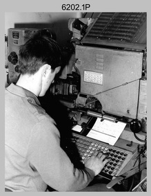
Photograph - Typesetting Equipment and Personnel, Army Survey Regiment, Fortuna, Bendigo, c1968 to 1979
... This is a set of nine photographs of cartographic typesetting equipment and personnel in Cartographic Squadron at the Army Survey Regiment, Fortuna, Bendigo circa 1968 to 1979. ...This is a set of nine photographs of cartographic typesetting equipment at the Army Survey Regiment, Fortuna, Bendigo, c1968 to c1979. ...Bendigo Military Museum 37 - 39 Pall Mall Bendigo goldfields This is a set of nine photographs of cartographic typesetting equipment and personnel in Cartographic Squadron at the Army Survey Regiment, Fortuna, Bendigo circa 1968 to 1979. ...This is a set of nine photographs of cartographic typesetting equipment and personnel in Cartographic Squadron at the Army Survey Regiment, Fortuna, Bendigo circa 1968 to 1979. The rooms on the top floor of Fortuna Villa where the photos were taken were formally the nursery and boys bedrooms during the Lansell family’s occupation of the building. The Fotosetter type setting machine replaced the letterpress method of type production in 1956. Its operator entered the text using a type order provided by cartographic draughtsmen/ draughtswomen. The type was output on a film positive, which was contacted onto strip film. The text was cut out by cartographic draughtsmen/ draughtswomen and affixed onto type sheets using bees wax. Cartographic Squadron’s CPL Arty Lane specialised in the operation of the Fotosetter type setting machine for many years, as shown in photos .3P and .4P. For more information on the Fotosetter, see page 71 of Valerie Lovejoy’s book 'Mapmakers of Fortuna – A history of the Army Survey Regiment’ ISBN: 0-646-42120-4. The computer based Editwriter Model 7500 typesetting system was introduced in 1975 as a replacement to the aging Fotosetter. It was operated by a specialised technician, who generated a large variety of map type styles and sizes quickly and reliably, as well as text panels. Output on Copy proof adhesive backed stripping type film replaced messy wax and spray adhesives in 1978. The Editwriter capability supported all RASvy units and its contractor type setting requirements. SGT Jim McDonald operated the Editwriter for a couple of years in the late 1970’s. He is seen in photos .7P and .8P. reading off a type order and entering text into the computer. See item 6181.23P, photo .1P for a reduced scale photo of SGT Jim McDonald undertaking this task. Also see item 6123.12P photos .1P and .2P featuring CPL Paul Richards, who was another technician that operated the Editwriter for several years in the 1980s. The Editwriter was also operated by SSGT Pat Lumsden, as featured in photo .9P taken in 1979. The Monotype Photolettering Machine seen in photos .5P and .6P is understood to be in service for a shorter period, as it was not as productive compared to the Fotosetter and Editwriter. This is a set of nine photographs of cartographic typesetting equipment at the Army Survey Regiment, Fortuna, Bendigo, c1968 to c1979. Black and white photos are on photographic paper and scanned at 300 dpi. .1) - Photo, black & white, c1960s, Fotosetter type setting machine, unidentified technician. .2) - Photo, black & white, c1960s, Fotosetter type setting machine. .3) to .4) - Photo, black & white, c1968, Fotosetter type setting machine, CPL Arty Lane. .5) to .6) - Photo, black & white, c1970s, Monotype Photolettering Machine, unidentified technician. .7) to .8) - Photo, black & white, c1979, Typesetting machine, ‘Editwriter’ Model 7500, SGT Jim McDonald. .9) - Photo, black & white, 1979, Typesetting machine, ‘Editwriter’ Model 7500, SSGT Pat Lumsden.Personnel and equipment are identified in photos .1P to .3P. on a card. A description is provided: ‘Fotosetter: This model was used from 1956 to 1974. Where photograph was taken: Army Survey Regiment. Person in Photograph: Arty Lane. Approx date photograph taken: 1968. Any Misc Information: All type on maps was set on this machine. The operator of the machine (Ex SGT Lane) joined the Army in 1956 and was discharged in 1977. Also with Survey from 1942 to 1946. Information given by: Arty Lane’. Photo .9P is dated 1979 on the back.’royal australian survey corps, rasvy, army survey regiment, army svy regt, fortuna, asr, carto -
 Bendigo Historical Society Inc.
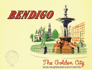
Book - BENDIGO THE GOLDEN CITY
... Printed while R.A.S.E. Cartographic Unit was in Fortuna, but before the Teachers' Training College was operating....Printed while R.A.S.E. Cartographic Unit was in Fortuna, but before the Teachers' Training College was operating. ...Bendigo the Golden City. Publisher: Nucolorvue Productions, Mentone, Victoria. 24 Pages. Photographs, illustrations, in colour. Printed while R.A.S.E. Cartographic Unit was in Fortuna, but before the Teachers' Training College was operating.bendigo, history, bendigo -
 Bendigo Historical Society Inc.
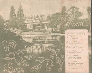
Document - THE BROOK AND ANDERSON FORTUNA COLLECTION: CHRISTMAS 1943 MENU
... L.H.Q. Cartographic Coy. Aust. Survey Corps. Christmas 1943 menu. ...History House 11 Mackenzie Street Bendigo goldfields MILITARY World war 2 L.H.Q. Cartographic Coy. Aust. Survey Corps. Christmas 1943 menu. ...L.H.Q. Cartographic Coy. Aust. Survey Corps. Christmas 1943 menu. Green cover with various festive drawing. Inside a picture of Fortuna with more festive drawing and the menu at the Corporals and Sappers' Mess.military, world war 2 -
 Bendigo Historical Society Inc.
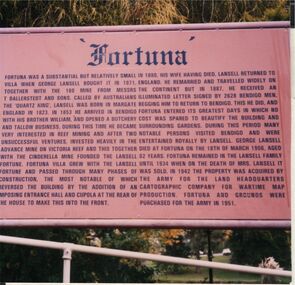
Photograph - FORTUNA COLLECTION: FORTUNA VILLA INTERPRETIVE SIGN
... Colour photograph: image of interpretive sign erected at Fortuna Villa, presumably by the Army Cartographic Corp during their time in residency. ...History House 11 Mackenzie Street Bendigo goldfields BENDIGO House fortuna villa Colour photograph: image of interpretive sign erected at Fortuna Villa, presumably by the Army Cartographic Corp during their time in residency. ...Colour photograph: image of interpretive sign erected at Fortuna Villa, presumably by the Army Cartographic Corp during their time in residency. Information regarding the Lansell family and the overall history of Fortuna Villa. Image taken 1990.bendigo, house, fortuna villa -
 Bendigo Military Museum
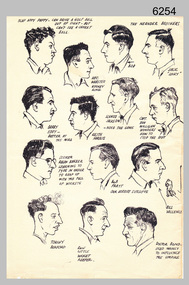
Drawing - Land Headquarters Cartographic Company’s Cricket Team Sketches, Fortuna, Bendigo, c1943
... This is a page containing portrait profile sketches of 14 members of Fortuna’s cricket team, possibly taken from a booklet published at Bendigo’s Land Headquarters Cartographic Company circa 1943. Fortuna’s involvement in the Bendigo community and local sporting competitions in the 1940s is covered in page 31 of Valerie Lovejoy’s book 'Mapmakers of Fortuna – A history of the Army Survey Regiment’ ISBN: 0-646-42120-4. ...This is a page containing profile sketches of 14 members of Fortuna’s cricket team, possibly taken from a booklet published at Bendigo’s Land Headquarters Cartographic Company circa 1943. Each sketch is annotated with the individual’s name or nickname, and some have witty comments in relation to their cricketing prowess. ...Land Headquarters Cartographic Company’s Cricket Team Sketches, Fortuna, Bendigo. ...This is a page containing portrait profile sketches of 14 members of Fortuna’s cricket team, possibly taken from a booklet published at Bendigo’s Land Headquarters Cartographic Company circa 1943. Fortuna’s involvement in the Bendigo community and local sporting competitions in the 1940s is covered in page 31 of Valerie Lovejoy’s book 'Mapmakers of Fortuna – A history of the Army Survey Regiment’ ISBN: 0-646-42120-4. It is noted Fortuna’s Cricket Team competed in the summer of 1943. From the annotations of each individual’s name or nickname and other comments, the team members were probably V15403 SGT RC Papworth, 315649 HR Webster, V301426 SGT JR Neander, V510526 SPR RL Neander, VX85797 SGT WH Eddy, VX121647 SGT KH Harris, VX110276 CPL HM Jackson or VX119801 LR Jackson, VX37958 CPL DD Milligan, VX37958 SPR RJ Barber, VX85798 WO2 RR Pratt, VX85805 SGT GW Vallence, VX86152 CP LA Burford, V275492 SGT Ron Little and VF510725 SPR VM Bond or VX100878 WO2 WJ Bond. This is a page containing profile sketches of 14 members of Fortuna’s cricket team, possibly taken from a booklet published at Bendigo’s Land Headquarters Cartographic Company circa 1943. Each sketch is annotated with the individual’s name or nickname, and some have witty comments in relation to their cricketing prowess. The black and white A4 size portrait sketch was printed on a single buff manilla card and are part of the Army Survey Regiment’s Collection. The sketch was scanned at 300 dpi. Each sketch is annotated: Top Row L to R: SLAP HAPPY PAPPY - CAN DRIVE A GOLF BALL OUT OF SIGHT - BUT CAN’T SEE A CRICKET BALL, HEC. WEBSTER – HOOKEY KING, THE NEANDER BROTHERS BOB, JACK “LUCKY”. Second Row L to R: BARRY EDDY – BETTER AT THE MIKE, KEITH HARRIS, SCHNOZ JACKSON - NOSE THE GAME, CAPT. DON MILLIGAN WONDERS HOW TO STOP THE ROT. 3rd Row L to R: SCORER RALPH BARBER LEARNING TO TYPE IN ORDER TO KEEP UP WITH THE FALL OF WICKETS, BOB PRATT OUR HERBERT SUTCLIFFE, BILL VALLENCE, Bottom Row L to R: TORCHY BURFORD, RON LITTLE WICKET KEEPER, DOCTOR BOND – USED MAINLY TO INFLUENCE THE UMPIRE. royal australian survey corps, rasvy, army survey regiment, army svy regt, fortuna -
 Bendigo Military Museum
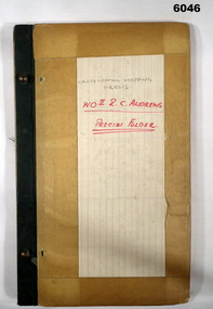
Journal - Cartographic Mapping Precis - WO2 R C Andrews Mapping Precis Folder, Circa 1960
... This is a compilation of Precis about cartographic mapping procedures to produce a map, compiled by WOII RC Andrews, Technical Warrant Officer Cartographic Squadron, retired 1975....Bendigo Military Museum 37 - 39 Pall Mall Bendigo goldfields This is a compilation of Precis about cartographic mapping procedures to produce a map, compiled by WOII RC Andrews, Technical Warrant Officer Cartographic Squadron, retired 1975. ...This is a compilation of Precis about cartographic mapping procedures to produce a map, compiled by WOII RC Andrews, Technical Warrant Officer Cartographic Squadron, retired 1975.Book with 2 x "chicago" screws, cardboard cover- brown, green cloth tape along binding edge"WO II R. C. ANDREWS PRECIS FOLDER"royal australian survey corps, rasvy, fortuna, army survey regiment, army svy regt, asr -
 Otway Districts Historical Society
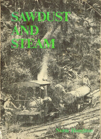
Book, Light Railway Research Society of Australia, Sawdust and Steam. Norman Houghton, December 1975
... Melbourne, 1975. Cartography: Alan Strempel....Melbourne, 1975. Cartography: Alan Strempel. Sawdust and Steam. ...Sawdust and steam. A history of the railways and tramways of the eastern Otway Ranges. Norman Houghton. IBSN 0 909340 03 X. Soft cover. iv, 106 p.; illus, maps. Melbourne, 1975. Cartography: Alan Strempel.steam and society; norman houghton; railways, east otways; tramways, east otways; tramways, forrest; coastal tramways; -
 Bendigo Military Museum
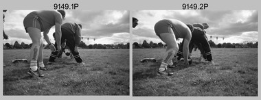
Photograph - Army Survey Regiment Inter-Squadron Athletics Competition, Bendigo, 1991
... Personnel from Headquarters, Air Survey, Cartographic and Lithographic Squadrons took part in traditional athletics events, wheelbarrow race, sack race, fireman’s carry and tug-of-war novelty events....Cam Bramich. .21) - Photo, black & white, 1991, tug-of-war, Cartographic Squadron L to R: Andrew Quin, Frank Savy, unidentified, Ian Baldwin. .22) - Photo, black & white, 1991, tug-of-war, Cartographic Squadron L to R: Matt Jackson CSM, Craig Kellet, Andrew Quin. .23) - Photo, black & white, 1991, tug-of-war, Cartographic Squadron: Ian Baldwin. .24) - Photo, black & white, 1991, tug-of-war, Cartographic Squadron L to R: Ian Baldwin, unidentified, Casey Northausen – facing away, Matt Jackson CSM, unidentified, Chris Woodman. .25) - Photo, black & white, 1991, tug-of-war, Cartographic Squadron L to R: Casey Northausen, Ian Baldwin, unidentified, Peter Tuddenham, Andrew Quin, Craig Kellet, Matt Jackson CSM, unidentified. ...Cam Bramich. .21) - Photo, black & white, 1991, tug-of-war, Cartographic Squadron L to R: Andrew Quin, Frank Savy, unidentified, Ian Baldwin. .22) - Photo, black & white, 1991, tug-of-war, Cartographic Squadron L to R: Matt Jackson CSM, Craig Kellet, Andrew Quin. .23) - Photo, black & white, 1991, tug-of-war, Cartographic Squadron: Ian Baldwin. .24) - Photo, black & white, 1991, tug-of-war, Cartographic Squadron L to R: Ian Baldwin, unidentified, Casey Northausen – facing away, Matt Jackson CSM, unidentified, Chris Woodman. .25) - Photo, black & white, 1991, tug-of-war, Cartographic Squadron L to R: Casey Northausen, Ian Baldwin, unidentified, Peter Tuddenham, Andrew Quin, Craig Kellet, Matt Jackson CSM, unidentified. ...This is a set of 48 photographs of an Army Survey Regiment inter-squadron athletics competition held at Epsom, Bendigo on the 4th of September 1991. Personnel from Headquarters, Air Survey, Cartographic and Lithographic Squadrons took part in traditional athletics events, wheelbarrow race, sack race, fireman’s carry and tug-of-war novelty events.This is a set of 48 photographs of an Army Survey Regiment inter-squadron athletics competition held at Bendigo on the 4th of September 1991. The photographs are on 35mm negative film and scanned at 2400 dpi. They are part of the Army Survey Regiment’s Collection. .1) - Photo, black & white, 1991, tunnel ball. Unidentified personnel. .2) - Photo, black & white, 1991, tunnel ball. Unidentified personnel, Ken ‘Sluggo’ Slater at far left. .3) - Photo, black & white, 1991, tunnel ball. Left team - Allison (Ottaway) Wooldrage 4th from front. Right team: 3rd - Sue (Foote) Bourne, 4th - Ailsa (Sorby) Miller, 5th - Paula (Golding) Brinsmead. In background L to R: Brian Paul, Mick Sarson, Mick Minchin. .4) - Photo, black & white, 1991, high jump. Unidentified athlete. .5) - Photo, black & white, 1991, high jump. Stuart Midgley. .6) - Photo, black & white, 1991, high jump. Scott Cameron. .7) - Photo, black & white, 1991, high jump, Matt Jackson CSM. .8) - Photo, black & white, 1991, distance race. Bob Garritty. .9) - Photo, black & white, 1991, distance race. CO LTCOL Rene van den Tol. .10) - Photo, black & white, 1991, distance race. Unidentified athletes. .11) - Photo, black & white, 1991, 100m sprint race. L to R: unidentified, Scott Cameron, Brendan McKinless, Barry Miller, remainder unidentified. .12) - Photo, black & white, 1991, 100m sprint race. L to R: unidentified (x2), Steve Wegener, Andrew Morrison-Evans. .13) - Photo, black & white, 1991, long jump. L to R: Roger Pearson, Dale Hudson, unidentified athlete. .14) - Photo, black & white, 1991, long jump. Dave Read. .15) - Photo, black & white, 1991, long jump. Unidentified athlete. .16) - Photo, black & white, 1991, long jump. L to R: Roger Pearson, unidentified athlete, Allan Hancox. .17) - Photo, black & white, 1991, long jump. L to R: unidentified athlete, Allan Hancox. .18) - Photo, black & white, 1991, long jump. Brendan McKinless, unidentified, Dale Hudson, unidentified athlete. .19) - Photo, black & white, 1991, long jump. Mick Hogan. .20) - Photo, black & white, 1991, long jump. Cam Bramich. .21) - Photo, black & white, 1991, tug-of-war, Cartographic Squadron L to R: Andrew Quin, Frank Savy, unidentified, Ian Baldwin. .22) - Photo, black & white, 1991, tug-of-war, Cartographic Squadron L to R: Matt Jackson CSM, Craig Kellet, Andrew Quin. .23) - Photo, black & white, 1991, tug-of-war, Cartographic Squadron: Ian Baldwin. .24) - Photo, black & white, 1991, tug-of-war, Cartographic Squadron L to R: Ian Baldwin, unidentified, Casey Northausen – facing away, Matt Jackson CSM, unidentified, Chris Woodman. .25) - Photo, black & white, 1991, tug-of-war, Cartographic Squadron L to R: Casey Northausen, Ian Baldwin, unidentified, Peter Tuddenham, Andrew Quin, Craig Kellet, Matt Jackson CSM, unidentified. Chris Woodman. .26) - Photo, black & white, 1991, tug-of-war, Headquarters Squadron L to R: Ken ‘Sluggo’ Slater, unidentified (x5), Paul Leskovec, unidentified, John ‘Stormy’ Tempest. .27) - Photo, black & white, 1991, tug-of-war, Headquarters Squadron L to R: Ken ‘Sluggo’ Slater, RSM WO1 Graham Ragless, unidentified, Geoff ‘GT’ Ford, Paul Leskovec, unidentified, John ‘Stormy’ Tempest. .28) - Photo, black & white, 1991, tug-of-war, Air Survey Squadron L to R: Grant Lloyd, unidentified. .29) - Photo, black & white, 1991, tug-of-war, Lithographic Squadron L to R: Peter Swandale, Tony Purton, unidentified, Shane Campbell, Syd Anstee, Graeme Spong, Dary; South. .30) - Photo, black & white, 1991, tug-of-war, Lithographic L to R: Syd Anstee, Graeme Spong. .31) - Photo, black & white, 1991, tug-of-war, Lithographic Squadron: Shane Campbell. .32) to .34) - Photo, black & white, 1991, discus. Unidentified athletes. .35) - Photo, black & white, 1991, discus. L to R: Bob Sheppard, Shaun Byers, Trevor Clarke, Ian Baldwin, Grant Lloyd. .36) - Photo, black & white, 1991, javelin. L to R: Ken Labouchardiere, unidentified, Shaun Byers, unidentified athlete, unidentified (x2). .37) - Photo, black & white, 1991, javelin. L to R: Cam Bramich, Penny Knott, Paula (Golding) Brinsmead, unidentified (x2). .38) - Photo, black & white, 1991, javelin. L to R: Penny Knott, Paula (Golding) Brinsmead, Cam Bramich, unidentified (x2). .39) - Photo, black & white, 1991, javelin. L to R: Tony Purton, Shane Campbell. .40) - Photo, black & white, 1991, sack race. Unidentified athlete, Brian Paul in left background. .41) - Photo, black & white, 1991, sack race. Perry Langberg. .42) - Photo, black & white, 1991, sack race. Noel ‘Nesty’ Coulthard, unidentified athlete in left background. .43) - Photo, black & white, 1991, sack race. Colin Cuskelly. .44) - Photo, black & white, 1991, sack race. Unidentified athlete. .45) - Photo, black & white, 1991, sack race. L to R: unidentified athlete, Gary Warnest. .46) - Photo, black & white, 1991, wheelbarrow race. Noel ‘Nesty’ Coulthard. .47) - Photo, black & white, 1991, wheelbarrow race. L to R: unidentified, Rob Bogumil, unidentified, Russell ‘Rusty’ Williams, Bill Jones, Geoff ‘GT’ Ford, Bob Rogister, Matt Jackson CSM. .48) - Photo, black & white, 1991, firemans carry. L to R: Keith Quinton, Daryl South.No personnel are identified.royal australian survey corps, rasvy, army survey regiment, army svy regt, fortuna -
 Bendigo Historical Society Inc.
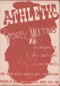
Programme - THE BROOK AND ANDERSON FORTUNA COLLECTION: ATHLETIC SPORTS MEETING
... LHQ Cartographic Company, Australian Survey Corps (OC Maj WM Sarll). ...History House 11 Mackenzie Street Bendigo goldfields MILITARY World war 2 LHQ Cartographic Company, Australian Survey Corps (OC Maj WM Sarll). ...LHQ Cartographic Company, Australian Survey Corps (OC Maj WM Sarll). Athletic sports meeting, Upper Reserve, Bendigo. Monday 31stJanuary 1944, first event at 12.45pm Eight pages listing all the events and the participants.military, world war 2 -
 Bendigo Historical Society Inc.
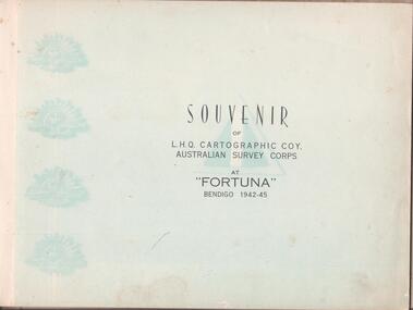
Book - THE BROOK AND ANDERSON FORTUNA COLLECTION: SOUVENIR OF CARTOGRAPHIC COMPANY AT FORTUNA
... Souvenir of L.H.Q. Cartographic Company, Australian Survey Corps at ''Fortuna'' Bendigo 1942-45. ...Souvenir of L.H.Q. Cartographic Company, Australian Survey Corps at ''Fortuna'' Bendigo 1942-45. ...Brown hardcover book. Souvenir of L.H.Q. Cartographic Company, Australian Survey Corps at ''Fortuna'' Bendigo 1942-45. A forward by the Officer Commanding W.M. Sarll (Major) is followed by photographs of all personnel divided in the various section. At the back a roll with all the names.royal australian survey corps, fortuna villa