Showing 1650 items in the category Documentation with item type Plan
-
 Port Melbourne Historical & Preservation Society
Plan - Handcoloured identification of wood and brick buildings, hotels and lanes on copy of a section of MMBW map, 1930s
Given to Peter LIBBIS, who hand ocloured legend etc. while researching his house and family, then donated to society in 1997.Photocopy of MMBW plan 326 - block between Stokes and Princes, Rouse and Graham. Colour coded for brick or wood builidngs, lanes marked in green and four hotels indicated.As abovereligion - roman catholic church (st josephs), peter libbis, business and traders - hotels, built environment -
University of Melbourne, Burnley Campus Archives
Plan, Royal Children's Hospital, 1989-1991
(1) Landscape Concept Royal Children's Hospital by Bates Smart and McCutcheon. (2) Tracing paper Sketch Plan. Scale 1:250 dated 29.3.90 by Jill Kellow. (3) Garden Project, The Foundation Royal Children's Hospital by Denise L. Stephens, DLS Design. Sheet 6 of 7, May 1990. Scale 1:100. (4) Photocopy of Surfaces and Playground Equipment, Royal Children's Hospital, August 1991. No 9046/01. Scale 1:100. (5) Photocopy of Surfaces and Playground Equipment, Royal Children's Hospital, August 1991. No 9046/02. Drawn By R.K. Scale 1:100.royal children's hospital, bates smart, jill kellow -
Bialik College
Plan (item) - Bialik College, 1970s
Two boxes of architectural plans of proposed Bialik College, 429 Auburn Road, Hawthorn East, created by architects Joshua and Mary Pila, c. 1970s. Box 1: 1970s, Box 2: 1979. Please contact [email protected] to request access to this record.1970s, building and planning -
Port Melbourne Historical & Preservation Society
Plan - Annotated and handcoloured by Peter Libbis to indicate his research into Libbis family residences and hotels on copy of a section of an MMBW map, Melbourne and Metropolitan Board of Works, c. 1980s
Peter LIBBIS obtained these copies from the MMBW when he researched his family history in the 1980s. He has annotated them, colour in hotels etc. Donated to Society in 1997.One of a group of 19 photocopies of various 20th century MMBW plans, annotated/coloured in to indicate residences of Libbis family and local hotels, by Peter LIBBIS in family and hotel research - Railway yards, Ross and Clark, South Graham c 1950sbusiness and traders - hotels, built environment - domestic, transport - railways, melbourne and metropolitan board of works, libbis family -
Port Melbourne Historical & Preservation Society
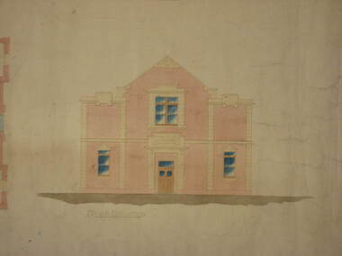
Plan - Entrance, Proposed Port Melbourne Library, Fred Cook, City Engineer, 12 Jan 1938
Plan of entrance elevation City of Port Melbourne Library 1938."Library Details":"Fred Cook City Engineer"built environment - civic, city engineers, fred cook, port melbourne library -
Moorabbin Air Museum
Plan (item) - Bristol Aeroplanes170 Schematic Drawings, Wiring on Main Stbd Dash Mk21 A/C
Bristol Aeroplane Company Ltd -
University of Melbourne, Burnley Campus Archives
Plan - Photocopy, New Cottage for Caretaker Royal Horticultural Gardens Burnley 1897, 1897
Photocopies. New cottage for Caretaker, Royal Horticultural Gardens Burnley (1) Elevations, Ground floor and Roof plans. Drawing No 1 dated 5th March 1897 GB 5198. (2) Detail Drawings. Drawing No 2. From Public Records Office.Signed SEM (?) 5-1-97; J. Fisher, F.J. Moore (?) 5 Mar. 97caretaker's cottage, burnley gardens -
Clunes Museum
Plan - Building Plans, Proposed Layout Plan Clunes Neighborhood House, 12 June 2009
Architectural plan of proposed Clunes Neighborhood House Free Lending Library Development.A1 size architectural plan of proposed Clunes Neighborhood House Free Lending Library Development. Includes floor plan, front and side elevations. Dated 12 June 2009 by Kevyn Joy Architects.clunes neighbourhood house, kevyn joy architects, building plans -
Port Melbourne Historical & Preservation Society
Plan - Side balcony, Port Melbourne Town Hall, Port Melbourne City Council, 1916
Plan - Details of side balcony, doors and main windows (1915 Town Hall).port melbourne town hall -
Glenelg Shire Council Cultural Collection
Plan - Plans / Line Drawings - Port of Portland Authority Slipway Fishing Vessel Soluna, Victoria, 06/10/1989
Port of Portland AuthorityFront: '33'- black texta, top right corner. 'JOB NO 3110' - black pen -
University of Melbourne, Burnley Campus Archives
Plan - Planting Design, Cul-de-sac Planting Design, Nov 2020
john rayner, garden plan, plant list -
Glenelg Shire Council Cultural Collection
Plan - Plans / Line Drawings - Port of Portland Slipway, Bilge Blocks Fishing Vessel Seamount Enterprise, Portland, Victoria, 08/11/1990
PORT OF PORTLAND AUTHORITY -
Port Melbourne Historical & Preservation Society
Plan - Proposed Bayside development, Sep 1987
SCDC plans for the Bayside development were revised as investigations into water circulation in artifical canals/harbour were completed. This is the altered plan, with alterations drawn in red on the original proposal, for the EES hearing in September 1987. The EES hearing, scheduled for three days in September, ran for 57 sessions into February 1988.Large plan of original proposed Bayside development as submitted to council in 1987; as 502.01 but with alterations superimposed in red, It was this altered plan that was submitted at the enquiry into the Environmental Effects Statement in September.In blue: EES Variation September 1987:In red: markings to indicate alterations to land configurationtown planning - proposals shelved - bayside, sandridge city development co pty ltd, scdc -
 Kew Historical Society Inc
Plan - Subdivision Plan, Forres Estate, East Kew, 1919, 1919
Pru Sanderson, in her groundbreaking ‘City of Kew Urban Conservation Study : Volume 2 - Development History’ (1988), summarised the periods of urban development and subdivisions of land in Kew. The periods that she identified included 1845-1880, 1880-1893, 1893-1921, 1921-1933, 1933-1943, and Post-War Development. These periods were selected as they represented periods of rapid growth or decline in urban development. An obvious starting point for Sanderson’s groupings involved population growth and the associated economic cycles. These cycles also highlighted urban expansion onto land that was predominantly rural, although in other cases it represented the decline and breakup of large estates. A number of the plans in the Kew Historical Society’s collection can also be found in other collections, such as those of the State Library of Victoria and the Boroondara Library Service. A number are however unique to the collection.Subdivision plans are historically important documents used as evidence of the growth of suburbs in Australia. They frequently provide information about when the land was sold on which a built structure was subsequently constructed as well as evidence relating to surveyors and real estate and financial agents. The numerous subdivision plans in the Kew Historical Society's collection represent working documents, ranging from the initial sketches made in planning a subdivision to printed plans on which auctioneers or agents listed the prices for which individual lots were sold. In a number of cases, the reverse of a subdivision plan in the collection includes a photograph of a house that was also for sale by the agent. These photographs provide significant heritage information relating house design and decoration, fencing and household gardens.An annotated subdivision plan for the Forres Estate, Kew East. The estate was advertised in 1919, the Melbourne Auctioneers being represented locally by Henry Kellett, Estate Agent of High Street, Kew. The name of the estate was derived from the mansion (demolished 2016) of the same name in Normanby Road, which was at one stage owned by the Mayor of Kew, Cr. J. S. Were.subdivision plans - kew, forres estate, argyle road, simpson street, hubert street, normanby road -
 Bendigo Military Museum
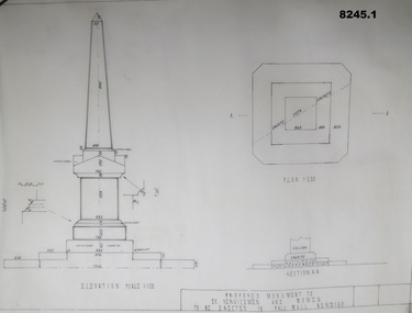
Plan - MONUMENT PLANS, C.1992
These plans were for a proposed Memorial to Ex Servicemen and Women to be erected in front of the Soldiers Memorial Institute in Pall Mall Bendigo. This building is now known as "The Bendigo Military Museum".1) .2) Two Cronaflex .004 thick black ink plans , scale 1 - 100showing front elevation and plan of a proposed Monument. Both plans are slightly different showing plan sections."Proposed Monument to Ex Servicemen and Women to be erected in Pall Mall Bendigo"brsl, smirsl, monument, plan, -
 Port Melbourne Historical & Preservation Society
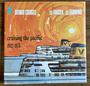
Plan - Ship plans, Melbourne Harbor Trust, 1980s
Ship Plans In 2 boxes labelled "Harbour Trust" .01 Flotta Lauro .02 Sea Princess .03 Shaw Saville - Ocean Monarch- MV Akaroa - Mv Arawa - MV Aranda .04 Chandris - Britanis - Queen Frederica .05 Sitmar - TV Fairsky - SS Fairsea - SS Fairwind - Fairstar .06 SS United States - Marco Polo - Monterey- Mariposamelbourne harbor trust - port of melbourne authority, flotta lauro, sea princess, ocean monarch, shaw savill, p & o, lauro line, britanis, chandris lines, sitmar, fairstar, fairsky, fairwind, marco polo, monterey, mariposa, ss united states, united states line, royal interocan lines, mv tswingi, mv akorda, mv arawa, mv aranda, queen frederica, fairsea, transport - shipping -
 Federation University Historical Collection
Plan, Department of Crown Lands and Survey, Melbourne, Buninyong County of Grant, 23/07/1929
The plan was photo-lithographed at the Departmen tof Lands and Survey, MelbourneA parish plan of Buninyong, including Robert Scott's Mt Buninyong Pre-emptive Right, Mt Buninyong Public Park, Thomas Learmonth's land, John Learmonth's land, Scotchan's, Yendon. The Buninyong POst Office is Allotment 1. Pisition of tracks in 1859 have been marked on the plan in red.buninyong, scotchman's, mt buninyong, robert scott, clarendon, lal lal creek, yendon, warrenheip, yarowee, enfield, thomas learmonth, john learmonth, archibald fisken, g. schloo, george innes, peter inglis, durham lead, j. fry, j. forrest, parkin lee, buninyong recreation reserve -
University of Melbourne, Burnley Campus Archives
Plan - Photocopy, Wendy Varcoe, Killamont, 1907? 1980?
Larger plan is probably of original fencing and drains from C.B. Luffman's layout. Killamont is the only known surviving private garden designed by Luffman.(1907).Photocopies of 2 hand drawn maps/plans of the garden at "Killamont." Drawn by Wendy Varcoe. Garden designed by C. B. Luffmann. (Also see B10.0040 Conservation Analysis and other C.B. Luffmann files in Box 75 A .)gardens, killamont, wendy varcoe, charles bogue luffman -
 Federation University Historical Collection
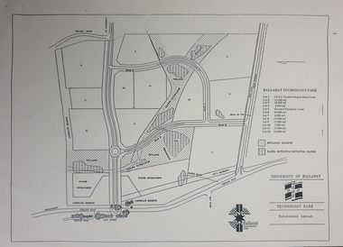
Plan - map, Ballarat Technology Park Wetlands Reserve and water retention basins, c1999
Yellow A4 page with a subdivision layout of the Ballarat Technology Park. It shows the Canadian Wetlands Researve and the water retentino.Detention Basins.canadian wetlands, ballarat technology park, mount helen campus -
University of Melbourne, Burnley Campus Archives
Plan, [Plan of Burnley Gardens], c.1940
Layout of Burnley Gardens in colour wash and ink. Framed and glazed. (Also unframed B11.0360.)burnley gardens -
 Federation University Historical Collection
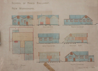
Plan, Ballarat School of Mines New Workshops, 1912, 08/1912
Original plan for new workshops for the Ballarat School of Mines. Includes elevations and sections, abd has been coloured with watercolour. The new workshops housed carpenters shop, plumbers, blacksmihing and stores. ballarat school of mines, new workshops, carpentry, blacksmithing, plumbing, architectural plan, laboratory -
Glenelg Shire Council Cultural Collection
Plan - Plans / Line Drawings - Port of Portland Authority Slipway Bilge Blocks, Wooden Vessel, Jane Kerr, victoria, 12/10/1982
PORT OF PORTLAND AUTHORITYFront: '8' - black texta, top right corner -
Port Melbourne Historical & Preservation Society
Plan - Coal tramway, Town Pier to Gas Works via Esplanade West, 1880s
From set of three photocopies of two plans of coal tramway, Town Pier to Gas Works via Esplanade West: Plan of coal tramwaytransport - tramways, utilities - gas, sandridge lagoon, industry - manufacturing, piers and wharves - town pier, metropolitan gas company, australasia sugar refining company, robert harper & co ltd -
 Kew Historical Society Inc
Plan, Melbourne and Metropolitan Board of Works, Borough of Kew : Detail Plan No.1580, 1904
The Melbourne and Metropolitan Board of Works (MMBW) plans were produced from the 1890s to the 1950s. They were crucial to the design and development of Melbourne's sewerage and drainage system. The plans, at a scale of 40 feet to 1 inch (1:480), provide a detailed historical record of Melbourne streetscapes and environmental features. Each plan covers one or two street blocks (roughly six streets), showing details of buildings, including garden layouts and ownership boundaries, and features such as laneways, drains, bridges, parks, municipal boundaries and other prominent landmarks as they existed at the time each plan was produced. (Source: State Library of Victoria)This plan forms part of a large group of MMBW plans and maps that was donated to the Society by the Mr Poulter, City Engineer of the City of Kew in 1989. Within this collection, thirty-five hand-coloured plans, backed with linen, are of statewide significance as they include annotations that provide details of construction materials used in buildings in the first decade of the 20th century as well as additional information about land ownership and usage. The copies in the Public Record Office Victoria and the State Library of Victoria are monochrome versions which do not denote building materials so that the maps in this collection are invaluable and unique tools for researchers and heritage consultants. A number of the plans are not held in the collection of the State Library of Victoria so they have the additional attribute of rarity.Original survey plan, issued by the MMBW to a contractor with responsibility for constructing sewers in the area identified on the plan within the Borough of Kew. The plan was at some stage hand-coloured, possibly by the contractor, but more likely by officers working in the Engineering Department of the Borough and later Town, then City of Kew. The hand-coloured sections of buildings on the plan were used to denote masonry or brick constructions (pink), weatherboard constructions (yellow), and public buildings (grey). The area represented in this detail plan has undergone significant change during the 20th century. The widening of High Street in the 1930s and 1950s involved the shops on the south side of High Street being demolished and later rebuilt to fit the widened street. Another significant loss was the mansion ‘Drayton’ fronting Wellington Street, owned at this stage by Susannah Fenton. Her family name would later to be given to Fenton Way, which was to be built over the grounds of the house following its demolition. The plan of the garden is particularly interesting, containing a batten dome fronting Wellington Street, an ornamental pond, a fountain and a brick and glass conservatory. The notes by the plumbing contractor on this plan are particularly detailed. Pink borders delineate the ownership of the varying parcels of land. Some of the better known owners listed include the real estate agent Cr. Henry de Castres Kellett (bt) and John Padbury, the funeral director. This particular plan provides a clear view of the configuration of the Kew Junction in 1903 and the commercial buildings that surrounded it.melbourne and metropolitan board of works, detail plans, maps - borough of kew, mmbw 1580, cartography -
Moorabbin Air Museum
Plan (item) - Bristol Aeroplane 170 schematic drawings, Access Door- Top Skin- Rear Front Spar
Bristol Aeroplane Company Ltd -
 Federation University Historical Collection
Plan, Plan for the Art Deco Facade on the Ballarat School of Mines Museum, c1920
Two hand-drawn and shaded architectural plans for the remodeling of the old Museum. .1) Plan for a new facade for the former Ballarat School of Mines Museum (formerly the Ballarat Wesleyan Church) showing front elevation. .2) Detail of front of the former Ballarat School of Mines Museum.ballarat school of mines, buildings, ballarat school of mines museum, art deco, former ballarat wesleyan church, grigsby, "a" hall -
University of Melbourne, Burnley Campus Archives
Plan, Swan Street Entrance. Also see B15.0352, 1988-1998
(1) 1 coloured and 2 copies, hand drawn , and 4 tracing paper sketches. Concept and Drawing by Steve Mullany, Lecturer V.C.A.H. Burnley, 09.12.1988. (2) 2 copies on tracing paper, original on paper with some additional notation and 3 copies of Landscape Plan by Steve Mullany 3 Feb 1989. (3) Photocopy of Project Eden, Swan Street, Richmond - Landscape Plan LA2 Project No 682 by Mark Mc Wha Pty. Ltd. Nov 1997. Includes Irrigation and Plant Schedule. (4) Coloured, Swan St Frontage Planting Scheme by P. Tulk for AMRAD 19.2.1998. -
Port Melbourne Historical & Preservation Society
Plan - Melbourne and suburbs sewerage works, MMBW, 1 Jul 1908
MMBW map of Melbourne and Suburbs sewerage work to 1-7-1908. Reticulation areas in red, reticulation areas under construction in blue.engineering - canals and drainage, engineering - board of works -
Port Melbourne Historical & Preservation Society
Plan - Proposed Bayside development, Aug 1987
SCDC plans for the Bayside development were revised as investigations into water circulation in artifical canals/harbour were completed. This is the plan as originally proposed prior to the EES hearing in September 1987.Large plan of original proposed Bayside development as submitted to council in 1987town planning - proposals shelved - bayside, sandridge city development co pty ltd, scdc -
 Flagstaff Hill Maritime Museum and Village
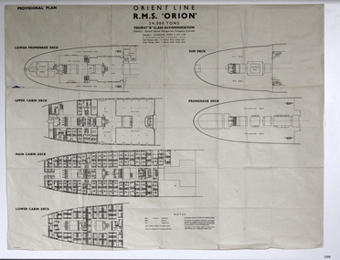
Plan - Ship Plan, Orient Steam Navigation Company, Orient Line, RMS Orion, ca. 1934
The Orient Steam Navigation Company Limited launched the Ocean Liner RMS Orion in 1934 and it remained in operation until 1963. The twin screw steamship was built to carry first class and tourist class passengers, over 1100 in all, plus almost 500 crew from Europe to Australia in comfort. The ship had a single funnel and a single mast. During WWII the vessel served as a troop carrier. The ventilation system noted on the plan, Punkah Louvre System, was designed for heating fresh air ventilation in buildings, ships and railroads. The system originated from Thermotank in Glasgow, Scotland. The ship plan for the RMS Orion is significant for its connection with the vessel. The ship was a leader, with several 'firsts'; the first Orient Line ship to be built with a single funnel since 1902, and the first to be painted in the Orient Line's livery, with a corn-coloured hull. It was the first liner to use chromium and bakelite materials for the surfaces throughout the ship, which provided greater resistance to the sea. It was also the first British ship to be fitted with air conditioning.Plan: printed provisional line drawing of the Orient line vessel "R.M.S. Orion". Inscriptions are printed on the plan. There are diagrams of six decks included in the plan. The ship is built for tourist "B" accommodation. The plan's Notices include details of the cabins including wardrobes, drawers, hinged seats, mattresses and bunk numbers. It also notes that there is a Punkah-Louvre System of Ventilation.Printed on the plan: "PROVISIONAL PLAN" "LOWER PROMENADE DECK" "UPPER CABIN DECK" "MAIN CABIN DECK" "LOWER CABIN DECK" "SUN DECK" "PROMENADE DECK" "ORIENT LINE / R.M.S. "ORION" / 24,000 TONS / TOURIST "B" CLASS ACCOMMODATION" "Owners: Orient Steam Navigation Company Limited"' "Managers : ANDERSON, GREEN & CO. LTD" "7 BISHOPS GATE, LONDON, E.C.2" "Chief Passenger Office : 14 Cockspur Street, London, S.W.1" "Branch Passenger Office : 1 Australia House, Strand, W.C.2" "notices"flagstaff hill, flagstaff hill maritime museum and village, warrnambool, maritime museum, maritime village, great ocean road, shipwreck coast, rms orion, plan, ship plan, provisional plan, orient line, orient ship, vissel orion, class b passenger accommodation, punkah louvre system of ventilation, deck plan, ship ventilation, ship floor plan, orient steam navigation company limited, anderson green & co ltd, steamship, ocean liner, war ship, troop carrier