Showing 1646 items
matching documentation
-
 University of Melbourne, Burnley Campus Archives
Plan, Burnley College Faculty of Agriculture Forestry and Horticulture
site plan -
Glenelg Shire Council Cultural Collection
Plan - Plan - subdivision at Cape Bridgewater, n.d
Black and white photocopy of a 1990s plan of a subdivision at Cape Bridgewater - 'Heritage Valley'. Twenty-eight lots . In two halves, not joined togethertown planning, residential, sub divide, cape bridgewater -
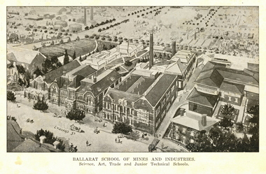 Federation University Historical Collection
Plan - Image, Ballarat School of Mines (Birds Eye View)
Birds Eye View of the Ballarat School of Minesballarat school of mines -
University of Melbourne, Burnley Campus Archives
Plan - Photocopy, Contour Map 1891, 1891
Photocopy of plan showing contour lines from Yarra River. Shows Pavilion and Principal's Residence but not much of the garden design. From Central Plan Office Dept. of Natural Resources."Contour map 1891" written in biroyarra river, pavilion, burnley horticultural college, burnley gardens -
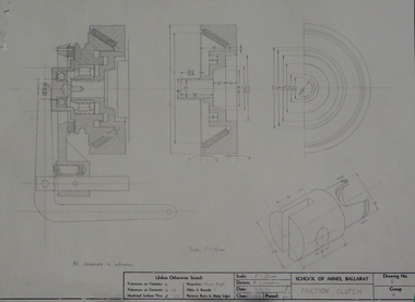 Federation University Historical Collection
Plan - Engineering drawing, 'Friction Clutch', 1974
Student's technical drawing ballarat school of mines, technical drawing, r.h. livingston, alumni -
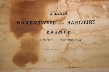 Bendigo Historical Society Inc.
Plan - Robert Moffatt Plan of Estate
A very old plan of the Estate or Robert Moffatt including Ravenswood and Harcourtnumerous numbers in pencilravenswood estate, harcourt, robert moffatt -
Glenelg Shire Council Cultural Collection
Plan - Plans / Line Drawings - Port of Portland Authority Slipway Fishing Vessel Soluna, Victoria, 06/10/1989
Port of Portland AuthorityFront: '33'- black texta, top right corner. 'JOB NO 3110' - black pen -
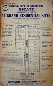 Kew Historical Society Inc
Plan - Subdivision Plan, Osburn Heights Estate, 1938
Edward Haughton & Co, in promoting the Osburn Heights Estate in what is now Balwyn North, attempted to capitalize on the subdivision’s proximity to East Kew. One section of the plan is includes the text: ‘The New Suburb: Camberwell North or East Kew (the names are synonymous)’. The Osburn Heights subdivision was part of a series of subdivisions running between Doncaster Road and Maud Street, including the ‘Pointed Firs Estate’ (MAP.0010). This subdivision included 13 ‘grand residential sites’ for sale in Doncaster Road, Maud Street and Osburn Avenue.subdivision plans - camberwell north, osburn heights estate -
 University of Melbourne, Burnley Campus Archives
Plan, K.O. Wood, Mechanical Ventilation System, 1946
Blue print of mechanical ventilation system for Assembly Hall by K.O. Wood, Mechanical Engineer. Dated 9.7.'46.k.o. wood, mechanical engineer, ventilation -
Moorabbin Air Museum
Plan (item) - Bristol Aeroplane 170 schematic drawings, Panel Additions for Auto Coarse Pitching
Bristol Aeroplane Company Ltd -
 Kew Historical Society Inc
Plan - Subdivision Plan, Bella Vista Estate, 1929
Pru Sanderson, in her groundbreaking ‘City of Kew Urban Conservation Study : Volume 2 - Development History’ (1988), summarised the periods of urban development and subdivisions of land in Kew. The periods that she identified included 1845-1880, 1880-1893, 1893-1921, 1921-1933, 1933-1943, and Post-War Development. These periods were selected as they represented periods of rapid growth or decline in urban development. An obvious starting point for Sanderson’s groupings involved population growth and the associated economic cycles. These cycles also highlighted urban expansion onto land that was predominantly rural, although in other cases it represented the decline and breakup of large estates. A number of the plans in the Kew Historical Society’s collection can also be found in other collections, such as those of the State Library of Victoria and the Boroondara Library Service. A number are however unique to the collection.The Kew Historical Society collection includes almost 100 subdivision plans pertaining to suburbs of the City of Melbourne. Most of these are of Kew, Kew East or Studley Park, although a smaller number are plans of Camberwell, Deepdene, Balwyn and Hawthorn. It is believed that the majority of the plans were gifted to the Society by persons connected with the real estate firm - J. R. Mathers and McMillan, 136 Cotham Road, Kew. The Plans in the collection are rarely in pristine form, being working plans on which the agent would write notes and record lots sold and the prices of these. The subdivision plans are historically significant examples of the growth of urban Melbourne from the beginning of the 20th Century up until the 1980s. A number of the plans are double-sided and often include a photograph on the reverse. A number of the latter are by noted photographers such as J.E. Barnes.Bella Vista (later ‘Malinda’) was a large Federation house designed by the architect Robert Haddon for Abel Hoadley. The house was built in 1902 and occupied the eastern corner of Thomas Street and Cotham Road. It was a single-storey, red brick house, set back from the road, featuring a central tower topped by a pagoda-like red terra cotta roof, on top of which was perched a very large terra cotta dragon. The Bella Vista subdivision of 1929 included Hoadley’s house as well as nine allotments facing Cotham Road and Alfred and Thomas Streets. In 1941, the land on which Hoadley’s house stood was to be further subdivided. Bella Vista is believed to have lasted until it was demolished in the 1980s.subdivision plans - kew, bella vista estate -
University of Melbourne, Burnley Campus Archives
Plan, Delysia Westwood, Tree Survey Central Gardens, 1986
Numbered plan with legend of trees in Central Gardens [Hawthorn]: Height, Diameter, Rating and comments for each tree. Dated November 1986 by Delysia Westwood. Scale 1:500.delysia westwood, tree survey, central gardens -
University of Melbourne, Burnley Campus Archives
Plan, Road Diversions, 1881-1889
Sketch plan of Burnley College grounds showing road diversions in 1881 and 1889.burnley college -
University of Melbourne, Burnley Campus Archives
Plan, Science Bench, c. 1960
Plan No. 3.science -
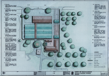 Federation University Historical Collection
Plan, City of Ballarat Botanic Gardens Nursery Masterplan
Four laminated plans from the City of Ballarat Botanic Gardens Nursery Masterplanballarat botanic gardens, ballarat botanic gardens nursery -
Moorabbin Air Museum
Plan (item) - C.A.C Fighter Scale : 1/24th XP.67
-
Glenelg Shire Council Cultural Collection
Plan - Ship Plan / Mould, n.d
Wooden, pattern for moulds for boat fittings. 'Waisted' cylinder: made in two parts, held together by wooden dowels; unpainted.Front: Inside of 1 piece - 'RON STEWART PORTLAND' - blue biro Other piece - '1 OFF brass' - blue biro Back: Outside of 1st piece -'bore hole -11/16 1 off' - pencil -
 Kew Historical Society Inc
Plan, Melbourne & Metropolitan Board of Works : Borough of Kew : Detail Plan No.1574, 1905
The Melbourne and Metropolitan Board of Works (MMBW) plans were produced from the 1890s to the 1950s. They were crucial to the design and development of Melbourne's sewerage and drainage system. The plans, at a scale of 40 feet to 1 inch (1:480), provide a detailed historical record of Melbourne streetscapes and environmental features. Each plan covers one or two street blocks (roughly six streets), showing details of buildings, including garden layouts and ownership boundaries, and features such as laneways, drains, bridges, parks, municipal boundaries and other prominent landmarks as they existed at the time each plan was produced. (Source: State Library of Victoria)This plan forms part of a large group of MMBW plans and maps that was donated to the Society by the Mr Poulter, City Engineer of the City of Kew in 1989. Within this collection, thirty-five hand-coloured plans, backed with linen, are of statewide significance as they include annotations that provide details of construction materials used in buildings in the first decade of the 20th century as well as additional information about land ownership and usage. The copies in the Public Record Office Victoria and the State Library of Victoria are monochrome versions which do not denote building materials so that the maps in this collection are invaluable and unique tools for researchers and heritage consultants. A number of the plans are not held in the collection of the State Library of Victoria so they have the additional attribute of rarity.Original survey plan, issued by the MMBW to a contractor with responsibility for constructing sewers in the area identified on the plan within the Borough of Kew. The plan was at some stage hand-coloured, possibly by the contractor, but more likely by officers working in the Engineering Department of the Borough and later Town, then City of Kew. The hand-coloured sections of buildings on the plan were used to denote masonry or brick constructions (pink), weatherboard constructions (yellow), and public buildings (grey). This plan shows several very large houses, particularly along Glenferrie Road, and the area now occupied by Ruyton Girls’ School. ‘Tarring’ (incorrectly spelled here as ‘Karring’) was built for Henry Henty in 1872, on part of his original allotment of 20 acres, and ‘Mount View’, which retains its original building and the fountain in the front garden, is part of Ruyton’s Junior School. The most significant change to Tarring and its grounds since 1903, involve the removal of a number of the outbuildings, including a Burmese temple, bought by Henty from the Burmese Exhibit at the Great Exhibition of 1880. It is shown on the plan as a summerhouse. The two-storey mansion, on the corner of Glenferrie Road and Wellington Street, was built in 1891 by leading architect Alfred White as his own home. Having an initial N.A.V. of £160, the house was purchased by a warehouseman Henry Lister, by 1900, when the N.A.V. was recorded at £111. By the turn of the century the house was known as ‘Comaques’. By contrast, much smaller houses are shown in Scott and Byron Streets, including a tiny Mission Hall in Byron Street, which belonged to the Anglican Church from at least 1903 to 1917.melbourne and metropolitan board of works, detail plans, maps - borough of kew, mmbw 1574, cartography -
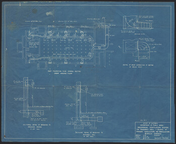
 Federation University Historical Collection
Plan, Ballarat School of Mines Development Plan, 1947, 09/12/1947
The Ballarat School of Mines was future planning before the proposed division of the tertiary division (Mt Helen Campus).Plan of the Ballarat School of Mines Lydiard Street Campus showing existing buildings, proposed demolition of all gaol buildings and court house. ballarat school of mines, development plan, former ballarat gaol, former ballarat court house, lydiard street, master plan, campus plan, ballarat school of mines campus -
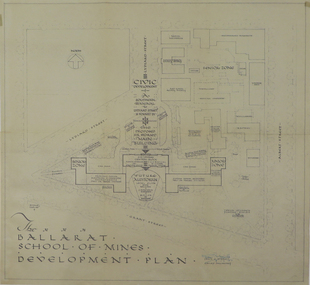
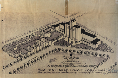 Federation University Historical Collection
Plan, Ballarat School of Mines Future Development: A Southern Terminal to Lydiard Street, 1947, 09/12/1947
In 1947 Percy Everett, Chief Architect for the Victorian Government, drew up plans to accomodate the growth in student numbers on the Ballarat School of Mines site. It was an era of government buildings surrounding the Ballarat School of Mines campus either being transfered to the school or foreshadowed for transfer. In 1947 two Red Cross huts were transferred from Victoria Park to the western side of the former Ballarat Supreme Court (later Courthouse Theatre) for use by Wool Classing and Motor Mechanics. In the same year additional facilities were provided for Pottery due to the increase in enrolments and a large brick classroom was built at the rear of the Ballarat Junior Technical School Building. In the annual report of 1947 the President said: "These transfers are, however, only temporary expedients and indicate the pressing need for more buildings of a permanent nature". By the end of the year the School Council decided to request the Education Department of Victoria to proceed with the implementation of the School's long-range plan whch had received approval earlier and to treat it as an urgent post-war requirement. After much communication a plan for a six-storied building, flanked by two three storied buildings was planned to be built on the site of the Ballarat Gaol was developed. The plan was sent to the Education Department for the Minister's Approval. It is not know if approval was granted, but the building did not proceed, possibly becausse the Ballarat Gaol was still very miuch in use. When a tertiary division of the Ballarat School of Mines was being developed in 1967 it corresponded with the closure of the Ballarat Gaol. It was determined that the Lydiard Street South site had no room for future growth so a new campus was sought. The new campus was purchased at Mt Helen, and was initially known as the Ballarat Insittute of Advanced Education. In 1976, when the Ballarat Teachers' College merged into the structure, the campus became known as the Ballarat College of Advanced Education and it was no longer a part of the Ballarat School of Mines. Plans for a proposed building to replace the Ballarat Gaol buildings. The proposed building was never built, the concept being replaced by a new teritary facility at Mt Helen. buildings, percy everett, ballarat school of mines battery, ballarat technical art school, engineering workshops, machine shop, ballarat junior technical school, architectural plans, ballarat school of mines, smb campus -
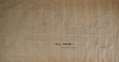 Bendigo Historical Society Inc.
Plan - HORWOOD COLLECTION: DRAWINGS FOR CONSTRUCTION OF 18'' ENGINE
Engineers plan for an 18 '' engine. Written on bottom 'J. Horwood and Sons, Engineers, Sandhurst. 18 IN Engine, Scale one inch = one foot' Plan drawn in fine black pen on waxed paper.bendigo, industry, horwood, foundry, mining equipment -
Moorabbin Air Museum
Plan (Item) - Plan SIAI Marchetti S211 Ex GAF
-
Port Melbourne Historical & Preservation Society
Plan - Evans Street from Ingles Street to Boundary Street, Engineering Department, Town of Port Melbourne, 1893 - 1919
Plan of Evans Street from Ingles Street to Boundary Street Loan no 5 1893.engineering - roads streets lanes and footpaths -
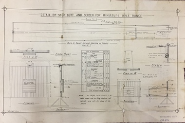 Kew Historical Society Inc
Plan, JC Brown, Detail of Step Butt and Screen for Miniature Rifle Range, 26 February 1910
On 19 July 1907, The Box Hill Reporter published an article on the Miniature Rifle Range. It stated: "Miniature Rifle Range for Kew. The Kew rifle club has made arrangements for the establishment of a miniature rifle range. The Kew borough council has provided a site in the yard at the rear of the town hall, fronting Brougham street. The site has been inspected by the military authorities, who have approved of the locality selected and the arrangements to be made to render the range absolutely safe. The plans are at present being prepared, and it is expected that the range will be completed within the next two months. The range will be under the direct control of the rifle club, subject to the supervision of a joint committee from the council and the club. The first committee will consist of Crs Wishart (mayor), Kellett, and Hiscock as representing the council, and Captain Argyle and Mr S. Abbott representing the rifle club. The range when completed will be available for the use of cadets, friendly societies, and other miniature rifle clubs in the district. Miniature rifle ranges are now occupying a great deal of attention in Great Britain, on the Continent, and in America. Lord Roberts, writing recently on the subject, remarks- "While I do not for a moment pretend that miniature rifle shooting is, in all respects, as useful as knowing how to shoot on a long range, I am satisfied that men can learn to shoot on miniature ranges, and that unless miniature ranges are very generally made use of, the greatest majority in this country will never learn to shoot at all." It is possible by this means also to divert the at present dangerous enthusiasm of uninstructed youths for the pea rifle into safer and more useful channels."Important early document identifying the specifications for a miniature rifle range in central Kew. Rifle clubs and rifle ranges were an important element in defending Victorians and Australians to outside threats. Single page plan (folded), created and approved in 1910, listing the approved specifications for a miniature rifle range in Brougham Street, Kew.Handwritten signature: J.M. / Staff officer for Works Victoria / 26-2-10rifle clubs - rifle ranges, miniature rifle ranges, rifle clubs -- kew (vic) -
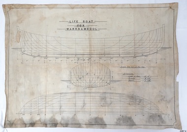 Flagstaff Hill Maritime Museum and Village
Plan - Vessel Line Drawing, Life Boat for Warrnambool, ca. 1900-1909
The plans were used for the construction of the lifeboat ‘Warrnambool’, which began 15th September 1909 and was completed almost 12 months later 1st September 1910. It was built at the Government Dockyard in Williamstown, Victoria, along the lines designed by Great Britain’s Royal Lifeboat Institution, and included whaleback decks fore and aft, mast and centreboard, and rudder and tiller hung from the sternpost. It could be propelled by both sail and oar. At that time Captain Ferguson was Chief Harbour Master and Mr Beagley was the foreman boat builder. Mr Beagley built the lifeboat with his fellow workmen. The boat was described as “… a fine piece of workmanship and does credit to her builders and designers…” It had all the latest improvements in shape, disposition of weight and watertight compartments, and it had space for a large number of people in addition to the crew. It appears that 'H Meiers' whose signature was on the plaque that was found concealed in the hull, was involved with the building of the lifeboat. His signature and the dates of the start and finish of the boat’s construction are pencilled on the raw timber 'plaque' found in the hull in the early 1990s when the lifeboat was being restored. It is interesting that the ‘Melbourne Directory’ of 1911, published by Sands and MacDougal, lists McAuley and Meiers, boat builders, Nelson Place foreshore, between Pasco and Parker Streets, Williamstown, (Victorian Heritage Database, ‘Contextual History, Maritime Facilities’), It is quite possibly the business of the person whose name is inscribed on the lifeboat plaque. Flagstaff Hill’s documentation also mentions that the keel was laid at ‘Harry Myers, boat builders, Williamstown, Melbourne’ – the name ‘Myers’ can also be spelled ‘Meiers’, which could be the same person as the Meiers in “McAuley and Meiers” (as mentioned in genealogy lines of Myers). The new lifeboat, to be named ‘Warrnambool’ was brought to town by train and launched at the breakwater on 1st March 1911 using the Titan crane (the old lifeboat built in 1858, was then returned to Melbourne in 1911). This new lifeboat was stationed at Warrnambool in a shed located at the base of the Breakwater, adjacent to the slipway. A winch was used to bring it in and out of the water. The lifeboat ‘Warrnambool’ was similar in size to the old lifeboat but far superior in design, build and sea-going qualities such as greater manoeuvrability. The ‘self-righting, self-draining design was “practically non-capsizeable” and even if the boat overturned it would right itself to an even keel and the water would drain away. The hull was built of New Zealand Kauri, using double diagonal planking, laid in two layers at right angles, with a layer of canvas and red lead paint between the timbers to help seal the planking. It has “… plenty of freeboard area, high watertight spaces between the deck and bottom… through which pipes lead…” The backbone timbers were made of Jarrah. The lifeboat Warrnambool was one of several rescue boats used at Port Fairy and Warrnambool in the early 1900s. In late 1914 the Warrnambool lifeboat and crew were used to help find what was left of the tragic wreckage of the Antares and were able to discover the body of one of the crewmen, which they brought back to Warrnambool. Between 1951 and 1954 the lifeboat was manned under the guidance of Captain Carrington. He held lifeboat practice each month on a Sunday morning, to comply with the Ports and Harbour’s request that lifeboats be manned by a strong and competent crew, ready for action in case of emergency. In the early 1960’s it ended its service as a lifeboat and was used in Port Fairy as a barge to help dredge the Moyne River, bolted to the Port Fairy lifeboat. Flagstaff Hill obtained the Warrnambool in 1975. In 1984 it was on display at Flagstaff Hill Maritime Village, Warrnambool. On 23rd May 1990, she was lifted from the water and placed in a cradle for restoration. The name ‘WARRNAMBOOL could be seen faintly on the lifeboat before it was restored. It was during the restoration that Flagstaff Hill's boat builder discovered the 'plaque' inside the hull. A copy of the blueprint plans has the name “V.E.E. Gotch” printed on it. His advertisement in Footscray’s ‘Independent’ newspaper of Saturday 11th May 1901 states he is “Principal and Skilled member (Naval Architect) to the Court of Marine Inquiry of Victoria and holds classes for naval architectural drawing and arithmetic.” The line drawing is significant for its connection with the lifeboat WARRNAMBOOL. The lifeboat is very significant to local and state history for its use in the lifesaving rescues of seafarers, particularly in Lady Bay. It was part of the local rescue equipment. It gave a half-century of service to the local community as a lifesaving vessel, including its involvement in retrieving the body of a shipwrecked crew member of the ANTARES. Line drawing in black ink and pencil on rectangular parchment or waxed linen. Drawing has diagrams of three profiles of a vessel, with measurements and connecting pencil lines on the left quarter. The plan is for the lifeboat named “Warrnambool”, which was built in Melbourne and completed in 1910. Old blue copies of the Lifeboat plan are archived also.“LIFE BOAT / FOR / WARRNAMBOOL” “Scale, One Inch to One Foot” “ “Length as shown 30’ – 8” “ “Breadth “ “ 8’ – 6 ½ “ “ “Depth “ “ 3’ – 4 ¾” “flagstaff hill, warrnambool, shipwrecked-coast, flagstaff-hill, flagstaff-hill-maritime-museum, maritime-museum, shipwreck-coast, flagstaff-hill-maritime-village, lifeboat, warrnambool lifeboat, boat plans, lifeboat plans, boat construction, boat building, line drawing, plan for lifeboat, life boat, life boat 'warrnambool', clinker design, 1910 lifeboat, life saving equipment, shipbuilding -
 Vision Australia
Plan - Image, New verandah & draining to court for the Royal Victorian Institute for Blind, April 1924
In 1924 plans were submitted to the RVIB board for the addition of a new veranda and associated drainage pipes located in the courtyard behind Ormond Hall. Hand written notes on the plan indicate that the tender for materials from Pollards was 330 pounds, asphalt 35 pounds totally a cost of 365 pounds. And that additional costs of 120 pounds, comprising of 20 for G Lavatory (?) and J Famdy (?) 100 pounds.1 architectural plans for proposed verandah and drainageStephenson & Meldrum, Architects Collins Court 374 Little Collins Street Melbourne Phone: 6990royal victorian institute for the blind, plans -
 Kew Historical Society Inc
Plan - Subdivision Plan, Old Kew Golf Links Estate - Third Section, 1920-1929
Pru Sanderson, in her groundbreaking ‘City of Kew Urban Conservation Study : Volume 2 - Development History’ (1988), summarised the periods of urban development and subdivisions of land in Kew. The periods that she identified included 1845-1880, 1880-1893, 1893-1921, 1921-1933, 1933-1943, and Post-War Development. These periods were selected as they represented periods of rapid growth or decline in urban development. An obvious starting point for Sanderson’s groupings involved population growth and the associated economic cycles. These cycles also highlighted urban expansion onto land that was predominantly rural, although in other cases it represented the decline and breakup of large estates. A number of the plans in the Kew Historical Society’s collection can also be found in other collections, such as those of the State Library of Victoria and the Boroondara Library Service. A number are however unique to the collection.The Kew Historical Society collection includes almost 100 subdivision plans pertaining to suburbs of the City of Melbourne. Most of these are of Kew, Kew East or Studley Park, although a smaller number are plans of Camberwell, Deepdene, Balwyn and Hawthorn. It is believed that the majority of the plans were gifted to the Society by persons connected with the real estate firm - J. R. Mathers and McMillan, 136 Cotham Road, Kew. The Plans in the collection are rarely in pristine form, being working plans on which the agent would write notes and record lots sold and the prices of these. The subdivision plans are historically significant examples of the growth of urban Melbourne from the beginning of the 20th Century up until the 1980s. A number of the plans are double-sided and often include a photograph on the reverse. A number of the latter are by noted photographers such as J.E. Barnes.When the old Kew Golf Links was subdivided in the mid 1920s, the developers were able to break the sale into sections. The third section included eighty lots. The lots faced Kilby Road, Kodak Avenue, Belford Road, Baker Avenue, Mathers Avenue, and White Avenue. [Kodak Avenue was renamed Page Avenue at a later date].The ‘Kew Conservation Study (1988) notes that ‘On the subdivision plan, Kodak’s involvement is commemorated by the naming of the streets after Company directors, and their decision to not proceed with the construction of the factory is explained as a response to the increase in the value of the land. This explanation may have been Estate Agent’s hyperbole, as the Kodak Company records suggest that the land, with its wide creek gully, was unsuitable and too small for its purposes.subdivision plans - kew, old kew golf links estate - third section -
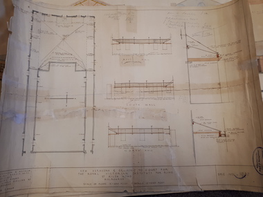
University of Melbourne, Burnley Campus Archives
Plan, VCAH Burnley College, Swan Street Richmond - Site Plan 1:1000 Fire Services Survey, 1991
Plan with Buildings named, External Hydrant Sources and Main Entry Points marked. Scale 1:1000. Dated January 1991.vcah, burnley, fire safety -
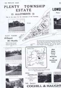 Greensborough Historical Society
Plan - Advertising Leaflet, Coghill & Haughton, Plenty Township Estate and Bryn Teg Hill's Estate, 1925c
Copy of Real Estate Agent's advertising leaflet for two subdivisions, the Plenty Township Estate and Bryn Teg Hill's Estate in Lower Plenty, by order of Mrs M Thomas (d. 1925)Black and white photocopy of advertising leafletlower plenty, bryn teg, plenty river -
Moorabbin Air Museum
Plan (item) - Bristol Aeroplane 170 schematic drawings, Assy. Real Spar Starboard
Bristol Aeroplane Company Ltd