Showing 1649 items in the category Documentation with item type Plan
-
 Federation University Historical Collection
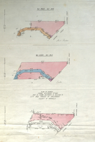
Plan, Plan of Survey Crown Allotment 9A and Part of Crown Allotment 8 Section 10 City and Parish of Ballaarat, after 1929
ink and watercolor on watermarked laid paper dated 1928text and measurementsballaraat, ballarat, plan, plan of survey, armstrong street, skipton street -
 Federation University Historical Collection
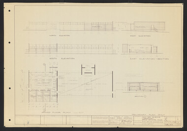
Plan, Ballarat School of Mines Clay Mill Building Alterations, 1962, 04/10/1962
Two plans for alterations to the Ballarat School of Mines Clay Mill Building to the Fluid Mechanics Labratory. .1) Existing Clay Mill Building .2) Plan and sections of proposed changes to the Clay Mill Building.john e. dixon, clay mill building, ceramics, ballarat school of mines, battery building -
 University of Melbourne, Burnley Campus Archives
Plan, L.R.B. Simmons, New Soil Science Laboratory, 1973
Plans by Govt. Of Victoria Public Works Dept.: L.R.B. Simmons (Senior Project Architect), D.C. Bradbury (Chief Architect), Drawn by Aldo Bellarmo. A. Proposed addition to existing laboratory. B. Plan of Section and Elevation of proposed new Soil Science laboratory.laboratory, glasshouse, l.r.b. simmons, d.c. bradbury, aldo bellarmo -
 Moorabbin Air Museum
Plan (item) - CAC Wirraway Agricultural Conversion XP.77 Drawing, C.A.C Wirraway Agricultural Conversion XP.77, 02/1957
This schematic was drawn by W. J. Watkins for the Commonwealth Aircraft Corporation during February 1957. It shows the XP-77 experimental conversion of the Wirraway general-purpose military aircraft. This drawing appears to depict the early stages of the CAC's Ceres design, which later had limited success as an agricultural aircraft carrying out tasks such as crop spraying. As the prototype first flew in February 1958, this diagram represents part of the development process for that aircraft. It also demonstrates an important phase in the history of the CAC, where, after the Second World War, the company was innovating in an attempt to stay relevant after the rapid shrinking of the RAAF. -
Glenelg Shire Council Cultural Collection
Plan - Plans / Line Drawings - Port of Portland Slipway Bilge Blocks Tug Buccaneer, Victoria, 30/09/1989
PORT OF PORTLAND AUTHORITY -
University of Melbourne, Burnley Campus Archives
Plan - Photocopy, Additions to Curator's Residence Royal Horticultural Gardens Burnley 1899, 1899
Photocopy. Additions to Curator's Residence, Royal Horticultural Gardens, Burnley. Elevations and Ground and Roof Plan. Drawing No 1 Stamped GB 5169. Dated 6.6.99. From Public Records Office.burnley gardens, curator's residence -
 Ringwood and District Historical Society
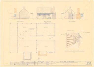
Plan - Ringwood Lake Reserve Museum Miners Cottage - 1983, Detailed Building Plans - 4 Sheets
Sheets 1, 2, 3 & 4 - Structural drawings for construction of miners cottage museum at Ringwood Lake Reserve, opened May, 1983. -
Port Melbourne Historical & Preservation Society
Plan - Alternative SCDC plan for Bayside development, Port Melbourne, Barry Merat, Foreshore Use, 1987
Display item used during public information sessions conducted in 1987 by the Port Melbourne City Council's Community Committee (Brenda BEDFORD, Frank CALLAGHAN, Ron WEST and Barry MERAT) regarding SCDC Bayside Development.Sketched plan illustrating alternative to SCDC plan for Bayside development.town planning - proposals shelved - bayside, public action campaigns, sandridge city development co pty ltd, scdc, brenda bedford, frank callaghan, ron west, barry merat -
 Ithacan Historical Society
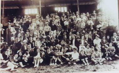
Plan, Ithacan Picnic - group photo, c1940
The group were photographed at an annual Ithacan Philanthropic Society picnic.A sepia photograph of a large group of people photographed in front of a grand stand. -
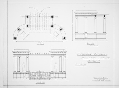 Friends of Ballarat Botanical Gardens History Group
Plan - Proposed Entrance to Gardens; Clegg and Morris Architects, Melbourne and Ballarat
Shows proposed elevations and sections of proposed structureHistoricPhotocopy ballarat botanical gardens, buildings, plan, entrance -
Federation University Historical Collection
Plan, Plan of 130 Victoria Street, Ballarat East, 1989, 1989
A colour photocopy of a plan of the proposed layout of dwelling and Student Dining / Kitchen Amenity at 130 Victoria Street.student residences, ballarat school of mines, 130 victoria street -
Glenelg Shire Council Cultural Collection
Plan - Ship Plan / Mould, n.d
Wooden pattern for mould for boat fittings. Rectangular, two smaller rectangles attached to either end, circular hole in middle with raised border around it. Unpainted, underside painted white. -
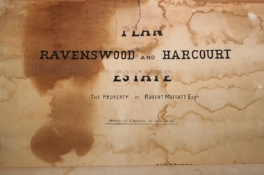 Bendigo Historical Society Inc.
Plan - Robert Moffatt Plan of Estate
A very old plan of the Estate or Robert Moffatt including Ravenswood and Harcourtnumerous numbers in pencilravenswood estate, harcourt, robert moffatt -
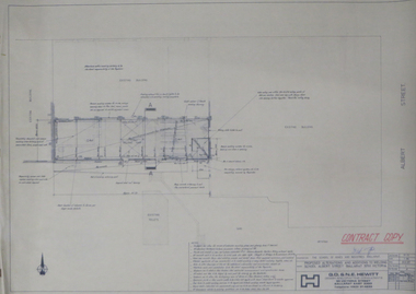 Federation University Historical Collection
Plan, Ballarat School of Mines Plans for Welding Additions
ballarat school of mines, buildings, g.d. & n.e. hewitt -
University of Melbourne, Burnley Campus Archives
Plan (Item), Gibson North Island Bed 1:50 Nov. '17, 2017 - 2019
-
 University of Melbourne, Burnley Campus Archives
Plan, Old Caretakers Cottage: Base Plan 1:100, 198-?
1. Tracing paper and paper plans of Old Cottage and surroundings. Scale 1:100. 2. Tracing paper copy of Caretaker's residence.cottage, caretaker, burnley, vcah -
Glenelg Shire Council Cultural Collection
Plan - Plans / Line Drawing Port of Portland Slipway Tuna Vessel 'Roza-S', c. 1986
Front: '24' - black texta, top right cornerport of portland -
 Kew Historical Society Inc
Plan - Subdivision Plan, Warne Estate, Undated
Pru Sanderson, in her groundbreaking ‘City of Kew Urban Conservation Study : Volume 2 - Development History’ (1988), summarised the periods of urban development and subdivisions of land in Kew. The periods that she identified included 1845-1880, 1880-1893, 1893-1921, 1921-1933, 1933-1943, and Post-War Development. These periods were selected as they represented periods of rapid growth or decline in urban development. An obvious starting point for Sanderson’s groupings involved population growth and the associated economic cycles. These cycles also highlighted urban expansion onto land that was predominantly rural, although in other cases it represented the decline and breakup of large estates. A number of the plans in the Kew Historical Society’s collection can also be found in other collections, such as those of the State Library of Victoria and the Boroondara Library Service. A number are however unique to the collection.The Kew Historical Society collection includes almost 100 subdivision plans pertaining to suburbs of the City of Melbourne. Most of these are of Kew, Kew East or Studley Park, although a smaller number are plans of Camberwell, Deepdene, Balwyn and Hawthorn. It is believed that the majority of the plans were gifted to the Society by persons connected with the real estate firm - J. R. Mathers and McMillan, 136 Cotham Road, Kew. The Plans in the collection are rarely in pristine form, being working plans on which the agent would write notes and record lots sold and the prices of these. The subdivision plans are historically significant examples of the growth of urban Melbourne from the beginning of the 20th Century up until the 1980s. A number of the plans are double-sided and often include a photograph on the reverse. A number of the latter are by noted photographers such as J.E. Barnes.The Warne Estate included four lots in Argyle Street, Kew. It represents a typical small-scale subdivision in this area. The lots for sale must have been further divided as there are now more houses in the street than there were blocks advertised in the subdivision. The agent left the proximity of the Outer Circle Railway off the plan. The Railway would have run along the triangular shaped lot 4. Lot 4 was offered for the sum of £600 plus the costs of footpath construction.subdivision plans - kew, warne estate -
 Kew Historical Society Inc
Plan - Subdivision Plan, Birdwood Estate, 1920
Pru Sanderson, in her groundbreaking ‘City of Kew Urban Conservation Study : Volume 2 - Development History’ (1988), summarised the periods of urban development and subdivisions of land in Kew. The periods that she identified included 1845-1880, 1880-1893, 1893-1921, 1921-1933, 1933-1943, and Post-War Development. These periods were selected as they represented periods of rapid growth or decline in urban development. An obvious starting point for Sanderson’s groupings involved population growth and the associated economic cycles. These cycles also highlighted urban expansion onto land that was predominantly rural, although in other cases it represented the decline and breakup of large estates. A number of the plans in the Kew Historical Society’s collection can also be found in other collections, such as those of the State Library of Victoria and the Boroondara Library Service. A number are however unique to the collection.The Kew Historical Society collection includes almost 100 subdivision plans pertaining to suburbs of the City of Melbourne. Most of these are of Kew, Kew East or Studley Park, although a smaller number are plans of Camberwell, Deepdene, Balwyn and Hawthorn. It is believed that the majority of the plans were gifted to the Society by persons connected with the real estate firm - J. R. Mathers and McMillan, 136 Cotham Road, Kew. The Plans in the collection are rarely in pristine form, being working plans on which the agent would write notes and record lots sold and the prices of these. The subdivision plans are historically significant examples of the growth of urban Melbourne from the beginning of the 20th Century up until the 1980s. A number of the plans are double-sided and often include a photograph on the reverse. A number of the latter are by noted photographers such as J.E. Barnes.Bordering Burke Road, the Birdwood Estate included a subdivision of 34 lots on either side of Birdwood Street, Balwyn. Six of the lots faced Burke Road. At the other end of the subdivision a line would indicate that a creek once bordered the subdivision. Lots were advertised for sale at a low figure on five-year terms. Purchasers could pay off the balance in twenty quarterly instalments (i.e. over five years).subdivision plans - balwyn, birdwood estate -
 Kew Historical Society Inc
Plan - Subdivision Plan, Myrtle Park Estate, City of Camberwell, 1916
The Kew Historical Society collection includes almost 100 subdivision plans pertaining to suburbs of the City of Melbourne. Most of these are of Kew, Kew East or Studley Park, although a smaller number are plans of Camberwell, Deepdene, Balwyn and Hawthorn. It is believed that the majority of the plans were gifted to the Society by persons connected with the real estate firm - J. R. Mathers and McMillan, 136 Cotham Road, Kew. The Plans in the collection are rarely in pristine form, being working plans on which the agent would write notes and record lots sold and the prices of these. The subdivision plans are historically significant examples of the growth of urban Melbourne from the beginning of the 20th Century up until the 1980s. A number of the plans are double-sided and often include a photograph on the reverse. A number of the latter are by noted photographers such as J.E. Barnes.The ‘Myrtle Park Estate’ was a subdivision bounded by Victoria Road (now Lansdowne Street), Buchanan Avenue and Dight Avenue. Other streets that were created by the subdivision included Eurolie Street, Boorahman Street and Moody Street (now Sylvan Street). The Estate took its name from Myrtle Park (later changed to Macleay Park), which had been created in 1923 by Camberwell Council. The Park adjoined the southeast corner of the new subdivision. The Estate included 74 regular allotments characterised by narrow frontages and long blocks. Confusion may have greeted prospective purchasers as the Estate was advertised in the daily newspapers as being in East Kew, rather than in Camberwell, where it was at that stage located.subdivision plans - balwyn, myrtle park estate - camberwell [surrey hills] -
University of Melbourne, Burnley Campus Archives
Plan, Re-organization of apple block, 1980 - 1982
Plans and lists with row numbers and names. (1) Almonds, quinces, figs, peaches, dated 20.02/81. (2) Crabapples, nectarines, peaches, flowering cherries, feijoas, currants and deciduous trees. Bud stock area - Crops (3) Citrus, plums, apricots, apples, pears, almonds, peaches, figs, quinces, medlars. (4) As for (3) but with amendments. (5) Pear Block.orchards -
Port Melbourne Historical & Preservation Society
Plan - Annotated and handcoloured by Peter Libbis to indicate his research into Libbis family residences and hotels on copy of a section of an MMBW map, Melbourne and Metropolitan Board of Works, c. 1980s
Peter LIBBIS obtained these copies from the MMBW when he researched his family history in the 1980s. He has annotated them, colour in hotels etc. Donated to Society in 1997.One of a group of 19 photocopies of various 20th century MMBW plans, annotated/coloured in to indicate residences of Libbis family and local hotels, by Peter LIBBIS in family and hotel research - Beach, Nott to Dow,South of Graham - date unknownbusiness and traders - hotels, built environment - domestic, transport - railways, melbourne and metropolitan board of works, libbis family -
Moorabbin Air Museum
Plan (item) - C.A.C 5 Roomed Cottage Of 10 Squares Model "CL"
-
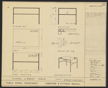 University of Melbourne, Burnley Campus Archives
Plan, N.S. Jemmerson, Specification for School Library Table, 1961
Plan. A. No. 47 B. No. 48 for Chief Architect, Ray Davey, Public Works Dept., Furniture & Fittings Branch. Drawn by N.S. Jemmeson.ray davey, n.s. jemmerson -
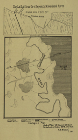 Federation University Historical Collection
Plan, Lal Lal Iron Ore Deposits, Moorabool River, 1881
This plan was printed in the Ballarat School of Mines Annual Report were Ferdinand Krause was a professor.Printed plan showing iron ore deposits at Lal Lal.lal lal ore, moorabool river, ferdinand krause -
Port Melbourne Historical & Preservation Society
Plan - Passenger ship, Oriana, shipside doors and centres of cranes, Vckers-Armstrong Ship Building Ltd, 1961
Plan - Passenger ship Oriana (1961) - shipside doors and centres of cranes - arrangement.melbourne harbor trust - port of melbourne authority -
 Kew Historical Society Inc
Plan - Subdivision Plan, Houghton Street & Buchanan Avenue, Balwyn North, ca. 1906
The Kew Historical Society collection includes almost 100 subdivision plans pertaining to suburbs of the City of Melbourne. Most of these are of Kew, Kew East or Studley Park, although a smaller number are plans of Camberwell, Deepdene, Balwyn and Hawthorn. It is believed that the majority of the plans were gifted to the Society by persons connected with the real estate firm - J. R. Mathers and McMillan, 136 Cotham Road, Kew. The Plans in the collection are rarely in pristine form, being working plans on which the agent would write notes and record lots sold and the prices of these. The subdivision plans are historically significant examples of the growth of urban Melbourne from the beginning of the 20th Century up until the 1980s. A number of the plans are double-sided and often include a photograph on the reverse. A number of the latter are by noted photographers such as J.E. Barnes.A hand-drawn subdivision plan listing six blocks bounded by Houghton Street, Doncaster Road, Buchanan Avenue and Maud Street, North Balwyn. Written on the plan of subdivision are the lot numbers, the dimensions of the blocks and the price at which two lots were for sale or had been sold for.subdivision plans - balwyn -
Federation University Historical Collection
Plan, Barkly Street Campus, Ballarat East, c1950s ?
Ink on paper plan: Barkly Street Campus. plans, barkly street campus, ballarat east, ballarat girls', ballarat girls' secondary school -
Port Melbourne Historical & Preservation Society
Plan - Proposed Beacon Cove Development plan by Sandridge City Development Company Pty Ltd, 17 July 1989
A photocopy of a detailed of areas 3,4,11,12, 5c, 5b & 5c of the plan for Beacon Cove from the Sandridge City Development Company Pty Ltd.sandridge city development company pty ltd, local government - city of port melbourne, beacon cove -
University of Melbourne, Burnley Campus Archives
Plan, Plan of the Melbourne Botanic Gardens, 1948
Partially coloured plan on a grid. Prepared from Field Notes of Survey by F.C. Ridoutt drawn and reproduced at the Dept. of Lands & Survey, Melbourne, March 1948.f.c. ridoutt, gardens, melbourne, royal botanic gardens melbourne