Showing 142886 items in the category Documentation
-
 Bendigo Historical Society Inc.
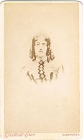
Photograph - ELMA WINSLADE WELLS COLLECTION: HARRIET ROTHERHAM (GRANDMOTHER )
COLLECTION OF PHOTOGRAPHS FROM MISS E.W.WELLS -black and white, faded PHOTO OF HARRIET ROTHERHAM (GRANDMOTHER).Bartlett Brothers photographersphotograph, portrait, female, 'bartlett bros. , view place sandhurst , photographers -
 Whitehorse Historical Society Inc.
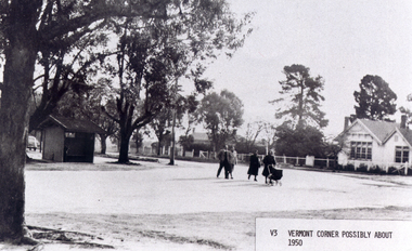
Photograph, Vermont Corner
Black/white - Vermont - Corner of Canterbury Road and Mitcham-Boronia Roads with Vermont Primary School, possibly about 1950vermont primary school no. 1022, canterbury road, vermont, mitcham road, boronia road, mitcham, armstrong, ian -
 Ballarat Tramway Museum
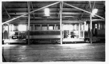
Photograph - Black & White Photograph/s, Keith Kings, 14/03/1949 12:00:00 AM
Black and White photograph contained with Reg. Item 1902 - Photo Album from Keith Kings to Les Denmead 1970. Photograph of SEC Ballarat tram No. 23, inside the depot, 14/3/1949 in unaltered condition. Has another tram undergoing repairs behind. Keith Kings No. B(w)(7) Scanning: i - image file, p - presentation file, b - back of photograph.Stamp in top left hand corner and handwritten number with "K.S. Kings No. B(w)(7) Copyright reserved". In blue ink "Ballarat / No. 23 / Unaltered, ex Adelaide / Depot 14/3/49"trams, tramways, ballarat, depot, adelaide, tram 23 -
 Kew Historical Society Inc
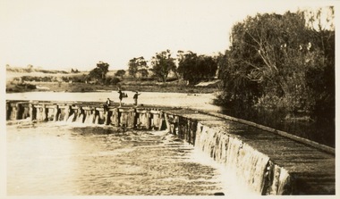
Photograph - Victorian Canoe Club, Dight's Falls, Studley Park, 1920-30
Canoeing on the River Yarra at Melbourne was an important and widespread recreational pursuit for Melbournians, especially in the first half of the twentieth century. The Victorian Canoe Club was formed in 1912 at a meeting in Melbourne and its first committee elected in the same year. Records indicate that the Club continued into at least the 1950s .The album has historic and social significance as a record of recreational activities (as well as canoe making) in the early years of the twentieth century. It has local significance as the site of the headquarters of the Club was in Studley Park. A number of photographs in the album provide vistas of Kew on the Yarra that are otherwise unavailable.One of 24 labelled photos in part album, originating from the Victorian Canoe Club, which had its headquarters in Studley Park, Kew. The album includes a photographic record of canoe construction and also locations in Studley Park and Kew where the canoes were used. The subject of this photograph is identified as 'Dight's Falls, Studley Park'.The view shows an early trestle bridge across the Falls on which people, possibly members of the Club, are standing. The point of view would appear to be looking up river towards Fairfield."Dyghts Falls, Studley Park"victorian canoe club, river yarra, burke road -- kew (vic.), dight's falls -- fairfield (vic.), dight's falls -- kew (vic.), dight's falls -- yarra river -
 Port Melbourne Historical & Preservation Society
Document - Port Melbourne Council re exempt properties, 1974 - 1978
Retained by donor from his service on Port Melbourne Council 1973-78Miscellaneous Port Melbourne Council documents 1974-78 list of exempt propertieslocal government - city of port melbourne, town planning, glen cosham -
 Eltham District Historical Society Inc
Photograph - Aerial Photograph, Landata, Eltham North, Vic, Apr. 1972
Centred on present day Eltham North reserve near Eltham North Primary School, Eltham North bounded by Allendale Road to north, Bellevue Road to south, Zig Zag Road and Beard Street to east and Ryans Road to west. Historic Aerial Imagery Source: Landata.vic.gov.au Aerial Photo Details: Project No :985 Project : MELBOURNE 1972 Run : 26 Frame : 190 Date : 04/1972 Film Type : B/W Camera : RC10 Flying Height : 5700 Scale : 9600 Film Number : 2636 GDA2020 : 37°41'52"S, 145°08'52"E MGA2020 : 336705, 5826102 (55) Melways : 11 J12 (ed. 42)aerial photo, neil webster collection, 1972-04, allendale road, beard street, bellevue road, eltham, eltham north, eltham north reserve, melway 11j12, ryans road, zig zag road, eltham north primary school -
 Whitehorse Historical Society Inc.
Photograph, Whitehorse Road, Mitcham, 1/10/2000 12:00:00 AM
Coloured photograph of Whitehorse Road/ Station Street corner.whitehorse road, mitcham, station street -
 Melbourne Tram Museum
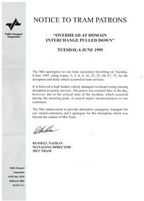
Document - Notice, Public Transport Corporation (PTC), "Notice to Tram Patrons", 6/06/1995 12:00:00 AM
Printed A4 sheet - "Notice to Tram Patrons" - apology for disruption when the overhead was pulled down at Domain Interchange - Tuesday 6 June 1995. Signed by Russell Nathan, Managing Director, Met Tram. Printed on PTC paper in black and white. Has been folded into three.trams, tramways, ptc, domain junction, notices and information, overhead, accidents -
 Flagstaff Hill Maritime Museum and Village
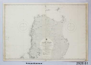
Document - Navigation Chart, Luzon Island, North of Latitude 16° 20' north
British Admiralty Navigation Chart - Phillippine Islands - Luzon Island, North of Latitude 16° 20' northwarrnambool, shipwrecked-coast, flagstaff-hill, flagstaff-hill-maritime-museum, maritime-museum, shipwreck-coast, flagstaff-hill-maritime-village, shipwrecked-artefact, navigation chart, british admiralty navigation chart, british admiralty, luzon island -
 Surrey Hills Historical Society Collection
Photograph - 7 Scheele Street, Surrey Hills, On The Street Where You Live Project
Photos documenting this address as part of a photographic series undertaken by volunteer photographers during 2013 and 2014 for The Street Where You Live Project. This was organised through the Surrey Hills Neighbourhood Centre and covered the postcode 3127 in the cities of Boroondara and Whitehorse.These photos provide a snapshot of real estate in the suburbs of Mont Albert and Surrey Hills during a period of rapid change with many properties on large blocks demolished to create higher density residential development or renewal of single dwellings. At particular risk were properties not covered by heritage overlays, especially interwar housing and post 1950's housing. -
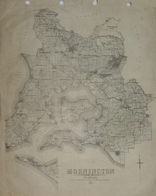 Federation University Historical Collection
Plan, Mornington, 1926, 1926
Printed plan on papermornington, phillip island, western port bay, bass straight, wonthaggi, lang lang, sherwood, nepean, narre worran, ringwood -
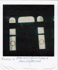 Kew Historical Society Inc
Photograph - 'Otira', 73 Walpole Street, 1978
Sanderson P (1988): '73 Walpole Street (Kew), 'Otira'. Built 1887. Original use - Residence. Architect - Crouch. Henry Berry, a noted philanthropist and salt merchant of Melbourne, was the original owner of this two-storey, boom-period house. Berry occupied the residence until his death in 1923 while in February the following year, the property was auctioned. Subsequently purchased by the Methodist Church for use as a training college for missionaries, a number of additions and alterations were made at that stage including a memorial chapel that was built on the property in 1957.' Otira is now a private residence. Original colour positive photograph (polaroid) of 'Otira', 73 Walpole Street, Kew, taken in 1978 by students in Form 3R at Trinity Grammar School as part of a project. The view is of the painted glass panels surrounding the main door, viewed from the hall."Photo 4 / Stained glass door panels Otira"otira - 73 walpole street, henry berry, historic houses -- kew (vic.), trinity grammar school, melbourne architects -- crouch, interior design -- front doors -- 1880s, interior design -- painted glass -- 1880s -
Moorabbin Air Museum
Manual (Item) - Ansett technical training powerplants, Aviation Maintenance Technician Integrated Training Program Study Guide Powerplant Section
Ansett Collection -
 Eltham District Historical Society Inc
Photograph - Digital Photograph, Alan King, Maroondah Aqueduct Siphon Bridge over the Plenty River, 26 January 2008
Opened in 1891, the bridge formed part of the Maroondah Aqueduct carrying water from Watts River near Healesville to the reservoir at Preston where it joined Melbourne's metropolitan water system. Covered under Heritage Overlay, Nillumbik Planning Scheme. Published: Nillumbik Now and Then / Marguerite Marshall 2008; photographs Alan King with Marguerite Marshall.; p99 Built to supply thirsty Melbourne in the late 19th century, the siphon bridge spanning the Plenty River off Leischa Court, Greensborough, was part of an engineering masterpiece. Opened in 1891, the bridge formed part of the Maroondah Aqueduct carrying water from the Watts River near Healesville to the reservoir at Preston where it joined the metropolitan distribution system. A major link in Melbourne’s water supply, it also had a huge impact on communities, which mushroomed along its route. Named after the Aboriginal word for the area around the Maroondah Reservoir, the Maroondah Aqueduct was fully operational until the 1970s. Since the 1980s the land along parts of the aqueduct have been used for walking and bicycle riding, shaded in places by Monterey Pine trees planted to stabilise the surrounding ground. From 1857 the Yan Yean Reservoir supplied Melbourne’s water but the growing city needed additional catchments.1 In 1886 work began on a weir on the Watts River to enable the aqueduct to carry most of the river water 41 miles (66km) to Melbourne. The aqueduct, built by the Board of Works, is the oldest remaining aqueduct near Melbourne and was probably the first built with concrete.2 Although the aqueduct is now only used between the Maroondah and Sugarloaf Reservoirs, it can still be traced across the Shire. It extends from the Maroondah Reservoir through Christmas Hills, Kangaroo Ground, Research, Eltham, St Helena and then previously wound west through Greensborough to Reservoir.3 Built by horse and manpower the aqueduct gravity fed 25 million gallons (113.6ML) of water a day to Melbourne along a gradient of one foot to the mile. It included 25 miles (41km) of open concrete and brick channel, six miles (10km) of tunnels, and nine miles (15km) of 14 inverted siphons of riveted wrought-iron across creeks. Bricks for the aqueduct were made from clay found near the sites and remains of several kilns can still be found between Kangaroo Ground and Christmas Hills. Building the aqueduct transformed local communities. An abattoir was established at Christmas Hills. Grog shanties and labourers’ camps sprang up and local courts dealt with cases of ‘petty pilfering and boisterous behaviour’.4 The Kangaroo Ground school population jumped to 91, crammed into a room with one teacher. Miners who built the tunnels camped just north of Churinga in Greensborough – then called Tunnel Hill Camp – and adjacent to the Evelyn Arms Hotel. The miners’ high spirits were sometimes quenched in horse troughs or by a ‘welt under the ear and kick on the behind’ as the local constable calmed them down rather than lock them up.5 But the growing city of Melbourne needed more water, so the O’Shannassy catchment, east of Warburton, was added to the system in 1914. In 1920 work began on the present concrete Maroondah Dam one mile (1.6km) from the weir on the Watts River. The aqueduct capacity was thus doubled to 50 million gallons (227ML) a day.6 Intense land development threatened to pollute the open water supply, so channel sections were replaced with large pipes. In the late 1960s a large water main was built from the tunnel outlet at Research and extended through St Helena and Greensborough, so this section of the aqueduct was taken out of use. Long sections of the unused open channels in Greensborough and Bundoora were destroyed, but the old channel in Research and Eltham North remained largely intact. In the 1970s, the Sugarloaf Reservoir was constructed, inundating 445 hectares of land in Christmas Hills. Sugarloaf was officially opened in 1980 and serves as a water storage and treatment plant supplying Melbourne. In the early 1980s pipes replaced the section from Sugarloaf Reservoir to the tunnel entrance at Kangaroo Ground. The Research-Kangaroo Ground tunnel operates as part of the pipeline system.This collection of almost 130 photos about places and people within the Shire of Nillumbik, an urban and rural municipality in Melbourne's north, contributes to an understanding of the history of the Shire. Published in 2008 immediately prior to the Black Saturday bushfires of February 7, 2009, it documents sites that were impacted, and in some cases destroyed by the fires. It includes photographs taken especially for the publication, creating a unique time capsule representing the Shire in the early 21st century. It remains the most recent comprehenesive publication devoted to the Shire's history connecting local residents to the past. nillumbik now and then (marshall-king) collection, maroondah aqueduct, pipe bridge, siphon bridge -
 Ringwood and District Historical Society
Photograph, Moving Presbyterian Church, Ringwood - 1916, Unknown date
Digital photographET Miles photo -
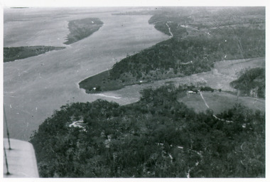 Lakes Entrance Historical Society
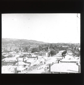
Photograph - Kalimna, Bulmer H D, 1940c
Black and white photograph of view over Kalimna, Maringa Creek, Saw Mill Flat, Fraser Island, Flannagan Island, aireal view. Lakes Entrance, Victoria.waterways, topography, townships -
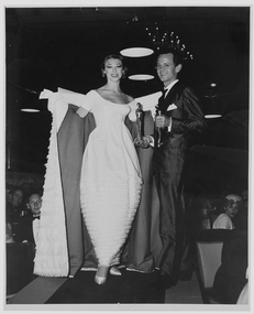 RMIT Design Archives
Photograph - Photographs, Photograph featuring Hall Ludlow and Diane Masters modelling Gown of the Year, 1959
The Gown of the Year Program was a gala event in Melbourne's cultural calendar. Australia's supermodels of the day, such as Diane Masters (pictured), Bambi Shmith, and Betty Jackson modelled clothes by Melbourne's leading designers, Hall Ludlow, Le Louvre, and others. Diane Masters has played a seminal role in contributing to the Design Archives through her personal and professional fashion archive, her role in the Hall Ludlow collection and archive, the Laurie Carew collection, and her generosity in gifting items from the Frederick Romberg archive to the RMIT Design Archives. She has been and remains a key figure in Melbourne and Australian fashion. Suzanne Davies, 2017Black and white photograph features fashion designer Hall Ludlow (right), holding his trophies for winning the 1959 Gown of the Year at the Menzies Hotel, Melbourne. Model Diane Masters (right) is wearing the winning gown: a pale full length gown with short sleeves, scoop neck, and ruffled skirt. The matching coat also features small ruffled down its length.Verso: Stamped in black ink, bottom right: 'Photographed by/ ATHOL SHMITH/ F.R.P.S . . F.R.S.A/ 125 COLLINS STREET, MELBOURNE/ TELEPHONE MF 5[illegible]4australian fashion, fashion design, mid-century modern -
Moorabbin Air Museum
Manual (Item) - Airborne ADF System Mk3
-
Glenelg Shire Council Cultural Collection
Photograph - Photograph - aerial view of Portland, c. 1954
Black and white aerial photograph of coastline around Portland. Black border, scale all sides, 5 rows of 3 't' at regular intervals. 75/25 land to ocean. Further left than 8475, ?end of beach.Front: '607 - 94 ' - handwritten, white, border 'RUN - 6 PORTLAND', printed, white, borderaerial photography, central portland, portland harbour, south west coastline -
 Stawell Historical Society Inc
Photograph, Deep Lead School and shelter shed 1947
Deep Lead School and shelter shed 1947stawell education -
 Warrnambool and District Historical Society Inc.
Photograph - Black and White Photograph
From Margaret Jansen -possibly a Wallace (or Wallace connection) Golden Wedding Anniversary celebration.anniversary, family history, local history, warrnambool -
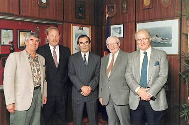 Port Melbourne Historical & Preservation Society
Photograph - City of Port Melbourne policy launch, c. 1992
Policy launch in the City of Port Melbourne Council Chamber. L - R Perce Maguire WHITE, Cr Chris RAEBURN (Mayor), Gerry HAND MHR, Frank CREAN (former MHR), Clive HOLDING MHR. Perce's notation of names & event on back of photograph.perce mcguire white, local government - city of port melbourne, frank crean, chris raeburn, gerry hand mhr, clive holding mhr -
Clunes Museum
Photograph
PORT PHILLIP GOLD MINE OF CLUNES EMPLOYED MANY MINERS WHO EVENTUALLY WENT TO WESTERN AUSTRALIA WHEN GOLD WAS DISCOVERED THEREORIGINAL PHOTOGRAPH OF EMPLOYEES OF THE PORT PHILLIP MINE. IN WOODEN FRAMESOME OF THE EMPLOYEES OF THE PORT PHILLIP GOLD MINING COMPANYlocal history, photograph, photography, mining -
![Dandenong State Forest, at Fern Tree Gully / [by] Nicholas Caire, circa 1876](/media/collectors/550653872162f11fb04854aa/items/577750a4d0cdd10a5c15e22b/item-media/57775147d0cdd10a5c165a58/item-fit-380x285.jpg) Kew Historical Society Inc
Kew Historical Society IncPhotograph, Anglo-Australasian Photographic Company, Dandenong State Forest, at Fern Tree Gully, c. 1876
Nicholas Caire was born on Guernsey in the Channel Islands in 1837. He arrived in Adelaide with his parents in about 1860. In 1867, following photographic journeys in Gippsland, he opened a studio in Adelaide. From 1870 to 1876 he lived and worked in Talbot in Central Victoria. In 1876 he purchased T. F. Chuck's studios in the Royal Arcade Melbourne. In 1885, following the introduction of dry plate photography, he began a series of landscape series, which were commercially successful. As a photographer, he travelled extensively through Victoria, photographing places few of his contemporaries had previously seen. He died in 1918. Reference: Jack Cato, 'Caire, Nicholas John (1837–1918)', Australian Dictionary of Biography, National Centre of Biography, Australian National UniversityAn original, rare photograph from the series 'Views of Victoria: General Series' by the photographer, Nicholas Caire (1837-1918). The series of 60 photographs that comprise the series was issued c. 1876 and reinforced a neo-Romantic view of the Australian landscape to which a growing nationalist movement would respond. Nicholas Caire was active as a photographer in Australia from 1858 until his death in 1918. His vision of the Australian bush and pioneer life had a counterpart in the works of Henry Lawson and other nationalist poets, authors and painters.Albumen silver photograph on boardprinted in ink on support l.c.: DANDENONG STATE FOREST, AT FERN TREE GULLY. / COPYRIGHT REGISTERED. printed in ink on support reverse c.: VIEWS OF VICTORIA. / (GENERAL SERIES.) / No. 12. / DANDENONG STATE FOREST, AT FERN TREE GULLY. / Fern Tree Gully is one of the favourite resorts for pleasure-seekers on holiday occasions. This scene is taken / from the camping ground at the entrance to the Gully. The residence in the centre of the picture is that of the / Forest-keeper, Mr. Kennedy, who has charge of the Dandenong State Forest. The trees on the hill at the back of / the residence, through apparently diminutive, are in reality gigantic ones, measuring in many instances from 15 to / 20 feet in circumference at the base. printed in ink on support reverse l.c.l.: J.W. FORBES, Agent, printed in ink on support reverse l.c.: ANGLO-AUSTRALASIAN PHOTOGRAPHIC COMPANY, MELBOURNE. printed in ink on support reverse l.c.r.: 10 Temple Court, Collins Street West.nicholas caire (1837-1918), landscape photography, ferntree gully -
 Bendigo Historical Society Inc.
Document - COPY OF WILLIAMSTOWN HISTORICAL SOCIETY NEWSLETTER NO 17 (1977)
Copy of Williamstown Historical Society Newsletter No 17 (1977).On the second and third page of this Newsletter is an article entitled ''The guns of the 'Nelson''', written by Doug Mills, Castlemaine. The Warship NELSON underwent alterations in 1860, including cut down to two decks and lengthened, her armaments reduced to 72 guns. Two 7inch 68 pounder guns were added to her armament. In February 7 1867 she was officially given to the Colony if Victoria by the Imperial Government. At the time her Commander was Captain Charles B. Payne. The Warship reached Melbourne in 4th February 1868. Relics of the NELSON were auctioned at Williamstown Victoria Naval Depot, and her two anchors are preserved for public display at Williamstown. An active demand for a share of the guns from various towns in the State. Ballarat received four (4) guns, Bendigo and Castlemaine two (2) each, while one has been given to each of the following towns: - Ararat, Tarnagulla, Hamilton, Bacchus Marsh, Echuca and Geelong.document -
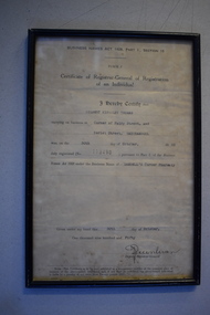 Warrnambool and District Historical Society Inc.
Document, Business Names :Gilbert Kingsley Thomas, C 1950
This certificate relates to the registration of an individual in association with a business. In this case Mr Gilbert Kingsley Thomas operating Sambell's Corner Pharmacy. The Sambell name has long been associated with pharmacies in Warrnambool. For the most part these pharmacies were at different places in fairy Street. From the block below Koroit St to Monaghans on the corner of Lava and Fairy Street. This business name of MR Gilbert Thomas operated from the corner of Fairy and Koroit St. This certificate has links to one of Warrnambool's longest established pharmaciesCream coloured framed certificate with black text and personal items typed into the form.Rectangular black painted frame.Gilbert Kingsley Thomas: 30th October 1950: Registration number 113490: Sambell's Corner Pharmacy:warrnambool, warrnambool chemists, gilbert kingsley thomas, gil thomas chemist -
 Ithacan Historical Society
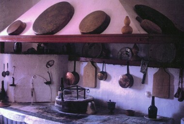
Photograph, Traditional Ithacan kitchen
Pictured is the open fire used for cooking that would have been found in a traditional Ithacan home. Whilst most now use electric and portable gas appliances, these open cooking areas can still be found in the kitchens of many of the old homes on the island. The mortar and pestle and baking dishes pictured are sill used today in the preparation of traditional dishes.Cooking and food is an intrinsic part of Ithacan culture and plays an important role in maintaining identity and traditions for the Melbourne's Ithacan community. Recipes and particular cooking techniques are passed on from generation to generation. A coloured photograph of the typical kitchen copper pans and cooking utensils used in a traditional Ithacan kitchen. -
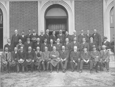 Stawell Historical Society Inc
Photograph, Group of Borough and Shire Councillors and Visitors 1922
Group of Borough and Shire Councilors and Visitors at a Back to Stawell 1922 Back Left to Right: T.D. O'Callaghan, C. Chamberlain (Town Clerk), A.E. Heal, J. Webster, J. Lysaght, W. Webster, R,. Tucker, D. Moore, J. Murray, J.G. McConachie, F.W. Bond, J. O'Connor, A. J. Wood. Middle: A.E. Tobin, W.F. Irvine, W.J. Foreshaw, G. Mitchell. A. Clarke, G. Barnes, W.A. Whitford, G.T. Holden, W.J. Nolan, G.A. Smith, E.P. Timmins, H. Henderson. Front: D.M. Mitchell, W. Simpson, J.C. Hutchings, D. Bell, Major Rough, J. Paton (Mayor), D. Williams (President) J. Williams, F.J. Derry. J. Hutchins, M. Cooper. Names in "Borough of Stawell" History. Magazine Box 1 (Mr. Sharpleys Book Page 17)Black and white photograph of a large group of men standing and seated in front of a building.1922 'Back to Stawell' Celebrations Borough & Shire Councilors & visitors (Names in "Borough of Stawell" History) Mag. Box 1. (Mr. Sharpley's Book) Page 17 Group of Borough and Shire Councilors at a luncheon given by CR. D. Williams Shire President, on the occasion of the "Back to Stawell", 1922. Back, Left to right - T.D. O'Callaghan, C. Chamberlain (Town Clark), A.E. Heal, J. Webster, J. Lysaght, W. Webster, R. Tucker, D. Moore, J. Murray, J.G. Maconachie, F.W. Bond, J. O'Connor, A.J. Wood. Middle - A.E. Tobin, W.F. Irvine, W.J. Foreshaw, G. Mitchell, A. Clarke, G. Barnes, W.A. Whitford, G.T. Holden, W.J. Nolan, G.A. Smith, E.P. Timmins, H. Henderson. Front - D. M. Mitchell, W. Simpson, J.C. Hutchings, D. Bell, D. McKay, Major Rough, J. Paton (Mayor) D. Williams, (President), J. Williams, F.J. Derry, J. Hutchins, M. Cooper. Original - Photo Chapman Stawell stawell government -
 Greensborough Historical Society
Map, Melbourne and Metropolitan Board of Works. Survey Division, MMBW, Yarra 2500 / 15.24. Diamond Creek, Grassy Flat Road, 1978_02
Melbourne and Metropolitan Board of Works. Yarra 2500 [base map] 15.24. Diamond Creek, Grassy Flat Road. Parish of Nillumbik 3310. Municipality of Diamond Valley 257. Prominent streets include: Everleigh Drive, Broad Gully Road and Clyde Street. Features include the Diamond Creek, Nillumbik Park and Diamond Creek Reservoir.MMBW Map in 1:2500 [scale] series. Cream parchment with green tape reinforcing on edges and punched holes on left edge.mmbw, melbourne and metropolitan board of works, diamond creek - maps, shire of diamond valley -
 The Beechworth Burke Museum
Photograph - Lantern Slide, c1900
This image shows a semi-aerial view of commercial and official properties lining Ford Street, Beechworth, in approximately 1900. The tower of Christ Church of St Peter and St Paul can be seen in the middle section of the photograph, on the left-hand side of the street. The Church was constructed in 1858 with the tower added to the structure in 1864. Lantern slides, sometimes called 'magic lantern' slides, are glass plates on which an image has been secured for the purpose of projection. Glass slides were etched or hand-painted for this purpose from the Eighteenth Century but the process became more popular and accessible to the public with the development of photographic-emulsion slides used with a 'Magic Lantern' device in the mid-Nineteenth Century. Photographic lantern slides comprise a double-negative emulsion layer (forming a positive image) between thin glass plates that are bound together. A number of processes existed to form and bind the emulsion layer to the base plate, including the albumen, wet plate collodion, gelatine dry plate and woodburytype techniques. Lantern slides and magic lantern technologies are seen as foundational precursors to the development of modern photography and film-making techniques.This glass slide is significant because it provides insight into Beechworth's built environment and commercial and official infrastructure in the early Twentieth Century, around the time of Australia's Federation into one nation. It is also an example of an early photographic and film-making technology in use in regional Victoria in the time period.Thin translucent sheet of glass with a square image printed on the front and framed in a black backing. It is held together by metals strips to secure the edges of the slide.burke museum, beechworth, lantern slide, slide, glass slide, plate, burke museum collection, photograph, monochrome, ford street, christ church of st peter and st paul, church tower, landmarks, 1900, shopping facilities, public buildings, 1900s, built environment, streetscape