Showing 1425 items matching " allotments"
-
 Ringwood and District Historical Society
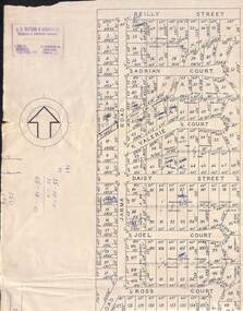
Map, Subdivision Plan of 141 allotments off Jarma Road, Heathmont, Victoria - Circa 1957
... Subdivision Plan of 141 allotments off Jarma Road ...Folded subdivision map on cardboard backing with real estate sales notations on some allotments. Subdivision includes Jarma Road, Reilly Street, Adrian Court, Valerie Court, Daisy Street, Joel Court, Ross Court, and Canterbury Road, Heathmont.Rubber stamp imprint in top left corner - J.S. Watson & Associates, Surveyors & Chartered Engineers, 7 Main Street Mornington, Phone Mornington 2186 & 24 Kensington Road, South Yarra, Phone BJ2155. -
 Bendigo Military Museum
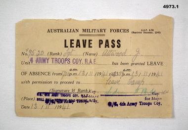
Document - ARMY DOCUMENTS, Australian Army, 1. Leave Pass, 2. Pay Allotments sheet, 1. 1940. 2. 1941
... 1. Leave Pass, 2. Pay Allotments sheet. ...See cat 4967.21. AMF Form AAF A96- Aust Military Force Leave pad - issued to V9520. Sgt Attwood J - 4 Army Troops Coy. RAE 13 Nov 1941. 2, AMF Form WF66 Military allotments - pay form V9520 Attwood J to Mrs Mary A Attwood of Bacchus Marsh Dated 15.10.43.2. Rubber stamp has "Checking staff 3rd M.D." 26 stamped 18 Oct 43.ww2, leave, pay -
 Bacchus Marsh & District Historical Society
Map, Village allotments, Parish of Myrniong, County of Bourke
... Village allotments, Parish of Myrniong, County of Bourke ...Myrniong is a village 9 kilometers west of Bacchus Marsh. Prior to 1863 the area was known as Blow's Flat. This map which was produced in 1903 and according to the catalogue record of this map held at the State Library of Victoria was based on an earlier map created in 1861. The early layout of streets for the village of Myrniong can be seen on this map. The streets shown are, Main Street, Hardy Street, Blow Street, Myrniong Street, Shuter Street, and Blackwood Street. An area marked as a reserve for a school can be seen between Hardy Street and Main Street.A single page paper map. A cadastral parish map of Myrniong in Victoria, showing numbered land allotments. Photo-lithographed at the Department of Lands & Survey, Melbourne, in 1903. Based on an original map created in 1861. The map is pasted into a bound volume containing 76 maps or plans in total. High resolution digital image stored on BMDHS computer network. Surveyed by John Hardy, Surveyor ; photo-lithographed at the Department of Lands & Survey, Melbourne by T.F. McGauran, 24.12.03myrniong parish plan, myrniong parish maps -
![Map, Plan of Town Allotments Bacchus Marsh [1873]](/media/collectors/5e461d8021ea67224c82f2a1/items/677a8ee7ab7bb47995c5573f/item-media/677a8fdeab7bb47995c55b56/item-fit-380x285.jpg) Bacchus Marsh & District Historical Society
Bacchus Marsh & District Historical SocietyMap, Plan of Town Allotments Bacchus Marsh [1873]
... Plan of Town Allotments Bacchus Marsh [1873] ...James Young was a prominent businessman, land owner and public figure in the early colonial period of Bacchus Marsh. After his death in 1871 land remaining from his estate in Bacchus Marsh was sold at auction in 1873. The sale of his estate included the substantial stone residence in Bennett Street which later became known as 'Stone Villa'. The sale of his land in 1873 was conducted by local auctioneer James Crook. 29 allotments were advertised for sale, although the plan for the sale indicated 30 allotments. The sale notice in the Bacchus Marsh Express of 11 October 1873 noted that the allotments were " in the very centre and heart of the most populous and business portion of the township, at the same time being the only remaining portion of the business block available for purchase by public sale, which fact intending purchasers should not lose sight of, as the opportunity cannot occur again". The designation of a new street, 'Bennett Street', shown on the plan, is also indicated in the advertising, "In reference to the main street frontages, opposite the Border Flour Mills. The Auctioneer would also direct attention to the plan, showing the formation of a new thorough fare (Bennett street) leading from Young street into Gell street, thus opening up the township on the high, more healthy, and commanding position so much to be desired for private dwellings".An important cartographic document which indicates an early major subdivision of land in the inner urban area of the Bacchus Marsh township. This subdivision lead to the continuing residential and commercial development of the township of Bacchus Marsh in the later part of the 19th century. The location of two well known demolished public structures, the Free Gardeners Hall in Gell Street, and the Old Mechanics Institute Hall (aka the Buffs Hall), on the corner of Young and Bennett Streets, are also shown on this map.A single page paper map showing 30 blocks of land for sale around 1873 in the vicinity of Bennett Street and Lerderderg Street. Described in contemorary sources as a 'lithographed copy'. No scale is indicated. The map is pasted into a bound volume containing 76 maps or plans in total. High resolution digital image stored on BMDHS computer network. land sales bacchus marsh, bacchus marsh victoria maps, james young 1816-1871, bacchus marsh roads and streets, bennett street bacchus marsh -
 Ringwood and District Historical Society
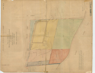
Map, Subdivision Plan - House and 13 residential allotments fronting Fremont Street Ringwood, Vic., and George Street (later Tudor Court), Heathmont, Vic. - Undated, circa 1922
... Subdivision Plan - House and 13 residential allotments ...Hand-drawn map on cardboard backing.Formed road with concrete kerbing. Water available to each block. No. of subdivision A139880 73/419. Part of Certificate of Title Vol 5323 Fol 539. Real estate sales notations on some allotments include price. Heading also includes address and phone number of H. Willis, Fremont Street Ringwood - WU6073. -
 Ringwood and District Historical Society
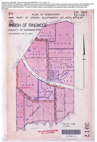
Document, Sale of Land Act documents - Part of Crown Allotments 14A, 40A, 40B & 4C, Parish of Ringwood - 1895
... Sale of Land Act documents - Part of Crown Allotments 14A ...Certificate of Title - Georgina Elizabeth Wingfield Knox, wife of William Robert Knox, part of allotments 14A and 40A, 27th November, 1895, and subsequent transfers up to 1959. Plan of Subdivision includes Allens Road, The Greenway, Dickasons Road, and Canterbury Road, Ringwood. (With further residential and commercial developments taking place since the 1920s, this area became part of the suburb of Heathmont.) -
 Melbourne Tram Museum
Drawing, "Plan of Survey of Part of Crown Allotments 15 and 16 at Hawthorn, Parish of Boroondara, County of Bourke", 1922
... "Plan of Survey of Part of Crown Allotments 15 and 16 at ...Drawing, coloured with water based drawing wash, titled "Plan of Survey of Part of Crown Allotments 15 and 16 at Hawthorn, Parish of Boroondara, County of Bourke". Shows the tram track, Wallen Road, changes around the intersection with Power St, buildings. A note at the bottom notes who owns what - MMTB and City of Hawthorn. Prepared by H. S. McComb, licensed Surveyor 6-9-1922. Stored folded.Stamped "Drawing Office" "Office Copy" and in red pencil "Hawthorn" in the bottom right hand corner, and on the rear "Drawing Office" "Office Copy" and "Hawthorn Depot" in pencil.trams, tramways, htt, mmtb, hawthorn depot, plans -
 Ringwood and District Historical Society
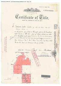
Document, Certificate of Title - Crown Allotments 4A, 4B, 11A, 11B, and Crown Sections 5 and 6 (later including Wonga Park, Vic.), Parish of Warrandyte, County of Evelyn - 17 June, 1895
... Certificate of Title - Crown Allotments 4A, 4B, 11A, 11B ...A4 copies of Landata Victoria Historical Search documents - Vol 2574 Fol 514725.Frederick Walter Purches of Ascot Vale, Wholesale Butcher, is now the proprietor of an Estate in Fee-simple - 2,291 acres 3 roods 24 perches or thereabouts, being Crown Allotments 4A, 4B, 11A, 11B, and Crown Sections 5 and 6, Parish of Warrandyte, County of Evelyn. Transfers include The Mutual Assurance Society of Victoria Limited, 15th August, 1896, The President Councellors and Ratepayers of the Shire of Lilydale, 13th March, 1899. -
 Ringwood and District Historical Society
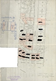
Document, Map showing numbered subdivision allotments with hand-written notations and redactions - 1924
... Map showing numbered subdivision allotments with hand ...Foolscap size page Map by Arnold Wilson & Associates, Engineers & Surveyors, 399 St.Kilda Road, Melbourne, Tel 26-1840 - 1924/4. Subdivision includes Ilford Road, Karen Court, Washusen Road and Dirkala Avenue, Heathmont. Also includes hand-drawn allotments on Canterbury Road and Balfour Avenue. Page rubber-stamped by building company A & C Jaworski, Office 2, 23 Ringwood Street, Ringwood 3134, Tel 870-0820, A.H. 870-2062. -
 Merbein District Historical Society
Map, White Cliffs Homestead Allotments and Farm Allotments, 15 Apr.1909
... White Cliffs Homestead Allotments and Farm Allotments ...farm allotments, homestead allotments, parish of yelta, parish of merbein, irrigation, blocks -
 Kew Historical Society Inc
Plan, J R Mathers & McMillan, 5 Splendid vVlla Allotments,: Segtoune St. & Windsor St., Kew, 1928
... 5 Splendid vVlla Allotments,: Segtoune St. & Windsor St ...Prue Sanderson, in her groundbreaking ‘City of Kew Urban Conservation Study : Volume 2 - Development History’ (1988), summarised the periods of urban development and subdivisions of land in Kew. The periods that she identified included 1845-1880, 1880-1893, 1893-1921, 1921-1933, 1933-1943, and Post-War Development. These periods were selected as they represented periods of rapid growth or decline in urban development. An obvious starting point for Sanderson’s groupings involved population growth and the associated economic cycles. These cycles also highlighted urban expansion onto land that was predominantly rural, although in other cases it represented the decline and breakup of large estates. A number of the plans in the Kew Historical Society’s collection can also be found in other collections, such as those of the State Library of Victoria and the Boroondara Library Service. A number are however unique to the collection.Subdivision plans are historically important documents used as evidence of the growth of suburbs in Australia. They frequently provide information about when the land was sold on which a built structure was subsequently constructed as well as evidence relating to surveyors and real estate and financial agents. The numerous subdivision plans in the Kew Historical Society's collection represent working documents, ranging from the initial sketches made in planning a subdivision to printed plans on which auctioneers or agents listed the prices for which individual lots were sold. In a number of cases, the reverse of a subdivision plan in the collection includes a photograph of a house that was also for sale by the agent. These photographs provide significant heritage information relating house design and decoration, fencing and household gardens.In 1928, five residential allotments bordering Segtoune and Windsor Streets were advertised for sale as part of a subdivision. Four of the blocks faced Segtoune Avenue. The auctioneers proclaimed the advantages of the sites: ‘Situate one minute from the High Street Electric Tram, which now runs direct to Spencer Street via Bridge Road and Flinders Street. Opposite the East Kew Railway Station (Outer Circle Line), which may be reopened In connection with the new Line from Kew to Doncaster; Adjacent lo the Kew Recreation Reserve, Sports Oval, and Swimming Bath; Half Minute from the Shopping Centre of East Kew, Accessible to the State School and Other Educational Centres’. The Harp of Erin Hotel and the route of the Outer Circle Railway line are marked on the plan. The Recreation Reserve and Sport Oval refer to Victoria Park. The Swimming Baths were located on the site of the current Kew Recreation Centre.subdivision plans - kew, segtoune street -- kew (vic.), windsor street -- kew (vic.) -
 Bendigo Military Museum
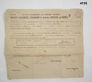
Financial record - MILITARY ALLOTMENTS, Department of defence 3rd Military District, 6.7.1918
... Allotments ...Norman McKenzie Rolls. The document relates to the cancellation of allotments from him to his Mother Mrs Agnes Rolls of Golden Square Bendigo.Document off white colour rectangular shape form Z.C.2, all print in black, typed in blue, initialled in red, purple stampin top RH corner, termination advice no “D27869”. Form relates to Military allotments for discharged, deceased or missing Soldier.Main points re Soldier, “No 3938 Pte Rolls, N.M 5th BTN”allotments, documents, payments -
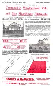 Ringwood and District Historical Society
Flyer, Advertisement for Mullum Mullum Road, Ringwood, Vic., Sale of "Bonnie View" Villa and five allotments. - 1923
... of "Bonnie View" Villa and five allotments. - 1923. ...Single page flyer advertising realising sale of villa and land in Mullum Mullum Road, Ringwood, at 3 o'clock on Saturday, August 18th, 1923. Also includes descriptions and photographs of the property, location of the blocks, and summary of local train services.Auctioneer - Knight & Harwood, 315 Collins Street, Melbourne, Tel 10615, 10616, in conjunction with local agent - J.B. McAlpin, Opposite Railway Station, Ringwood, Tel. Ringwood 7. -
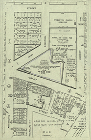
 Ringwood and District Historical Society
Map, Allotments - Township of Ringwood - Parish of Ringwood - County of Mornington - 1886, 1886
... Allotments - Township of Ringwood - Parish of Ringwood ...[Page 3, Horse Shoes to High Heels - Richard Carter] ... "(In the year 1882) the railway was extended from Hawthorn through Ringwood to Lilydale and later to Ferntree Gully." Linen-backed map of Ringwood area lithographed at the Department of Lands and Survey, Melbourne, 5th November, 1886.old lilydale road, new lilydale road, victoria brick and tile co., ringwood brick co., federal brick co. -
 Eltham District Historical Society Inc
Slide - Photograph, Eltham Shire Council, Plan of Subdivision, Part of Crown Allotments 5 & 6, Section 10, Parish of Nillumbik, County of Evelyn (Foster Road, Eltham East), 1969
... Plan of Subdivision, Part of Crown Allotments 5 & 6 ...35mm colour positive transparency blue Agfacolour Service plastic mountC5(a) DU (Vic) D/L Foster Road, Eltham East, 4 August 1969infrastructure, map, planning, subdivison lots, abersham court, ancona close, eltham east, floriston grove, foster road, frank street, gladwyn court -
 Federation University Historical Collection
Plan, Ballarat School of MInes Allotments
... Ballarat School of MInes Allotments ... -
Ringwood and District Historical Society
Legal record - Conditions of Sale (C.E.Carter), Ringwood East - Crown Allotments 35 & 36 - R. Davidson to Mrs J. A. E. Tudman. 1926
... Ringwood East - Crown Allotments 35 & 36 - R. Davidson to ...Particulars and Conditions of Sale of Property , from Robert Davidson to Jessie Tudman -
Stawell Historical Society Inc
Map, Department of Crown Lands and Survey Victoria, Allotments in the Township of Banyana. Parish of Burrum Burrum. 1946 / 1971, 1971
... Allotments in the Township of Banyana. Parish of Burrum ...Richardson River. Avon River JunctionPaper Map of County of BorungReprint of the 1946 edition. Drawn and reproduced at the Department of Crown Lands and Survey Victoria 1971.survey -
Tatura Irrigation & Wartime Camps Museum
Poster, Subdivision of Township Allotments
... Subdivision of Township Allotments ...Poster depicting the land which was being sold by J S Darby on the 3 December 1890. Auctioneer was Martin Cussen and Co. Map shows location of land.Single sheet of paper, laminated. Advertising land subdivision for sale in the township of Rushworth. Being sold by Martin Cussen and Co, auctioneers for J S Darby. Shows map of land subdivision.rushworth, land subdivision, martin cussen and co, j s darby -
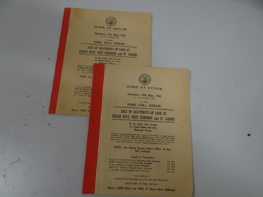 Brimbank City Council
Land Sale Booklet x 2 (2 copies of the same booklet), Sale of allotments of land at Keilor East, West Essendon and St Albans 1954
... Sale of allotments of land at Keilor East, West Essendon ...land sale -
 Kew Historical Society Inc
Plan - Subdivision Plan, 6 Choice Residential Allotments: East Kew, 1932
... 6 Choice Residential Allotments: East Kew ...Prue Sanderson, in her groundbreaking ‘City of Kew Urban Conservation Study : Volume 2 - Development History’ (1988), summarised the periods of urban development and subdivisions of land in Kew. The periods that she identified included 1845-1880, 1880-1893, 1893-1921, 1921-1933, 1933-1943, and Post-War Development. These periods were selected as they represented periods of rapid growth or decline in urban development. An obvious starting point for Sanderson’s groupings involved population growth and the associated economic cycles. These cycles also highlighted urban expansion onto land that was predominantly rural, although in other cases it represented the decline and breakup of large estates. A number of the plans in the Kew Historical Society’s collection can also be found in other collections, such as those of the State Library of Victoria and the Boroondara Library Service. A number are however unique to the collection.Subdivision plans are historically important documents used as evidence of the growth of suburbs in Australia. They frequently provide information about when the land was sold on which a built structure was subsequently constructed as well as evidence relating to surveyors and real estate and financial agents. The numerous subdivision plans in the Kew Historical Society's collection represent working documents, ranging from the initial sketches made in planning a subdivision to printed plans on which auctioneers or agents listed the prices for which individual lots were sold. In a number of cases, the reverse of a subdivision plan in the collection includes a photograph of a house that was also for sale by the agent. These photographs provide significant heritage information relating house design and decoration, fencing and household gardens.The mansion Woodlands in Harp Road, East Kew suffered the death of a thousand cuts. In its case, the cuts were subdivisions. Previous subdivisions of the mansion and its grounds were given titles such as ‘The Eastlawn Estate’ (MAP.0055), whereas at the end, the subdivision called it as it was, naming itself the ‘final section of the Woodlands Estate’ when it was put up for auction in 1932. The emphasis in the promotion of the subdivision was that it provided purchasers with splendid opportunities ‘to build modern homes in select, well established modern surroundings’. As with other subdivisions in the interwar period, transport links were emphasised. The six residential lots cut Woodlands off from Harp Road. When the vendor, Louisa Rachel Preston Hill, was to die at Woodlands in 1937 aged 86 her address was given as Normanby Road.subdivision plans - kew, woodlands estate -
University of Melbourne, Burnley Campus Archives
Map, Plan of Early Melbourne Showing Original Crown Allotments, c. 1852
... Plan of Early Melbourne Showing Original Crown Allotments ...Copy of 'Map of the City of Melbourne, and its Extension, together with Collingwood, Richmond, Hawthorne, the Emerald Hill, and a portion of Prahran Compiled from the Government Plans and Private Survey by William Green.' (2 copies, one enlarged)melbourne, william green, richmond, hawthorne, collingwood -
Merbein District Historical Society
Map, White Cliffs Irrigation Settlement - Plan of Homestead Allotments, 1917
... Allotments ...blocks, irrigation, parish of merbein, homestead allotments -
Merbein District Historical Society
Map, White Cliffs Irrigation Settlement - Plan of Homestead Allotments, 1917
... Allotments ...homestead allotments, parish of merbein, county of karkarooc, blocks, irrigation settlement -
Merbein District Historical Society
Map, Birdwoodton (Merbein) Allotments - Sec A, 4 Mar.1938
... Birdwoodton (Merbein) Allotments - Sec A ... -
Merbein District Historical Society
Map, Township of Merbein - Sale of Allotments, 29 Jul.1914
... Township of Merbein - Sale of Allotments ... -
Merbein District Historical Society
Map, Parish of Merbein - Irrigation Allotments, 3 Aug.1912
... Parish of Merbein - Irrigation Allotments ...irrigation -
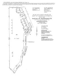 Ringwood and District Historical Society
Document - Subdivision Plan, LP113220 Part of Crown Allotments 35 & 39B, Parish of Warrandyte, County of Mornington, Vol 6421 Fol 183 & 184 - 1965
... LP113220 Part of Crown Allotments 35 & 39B, Parish of ...LANDATA Land Victoria 2-sheet plan printout dated 2009Sheet 1 includes Kalinda Road, Ringwood. Additional markings include LP113117. Sheet 2 includes Kalinda Road and Maroondah Highway, Ringwood. Additional markings include LP86253. Both sheets include location of Drainage and Sewerage Reserve along Mullum Mullum Creek. -
 Ringwood and District Historical Society
Document - Map, Plan of Subdivision - Part of Crown Allotments 14A & 14C, Parish of Ringwood, County of Mornington, Vol 5378 Fol 511 - 1927
... Plan of Subdivision - Part of Crown Allotments 14A & 14C ...Department of Lands and Survey photocopy dated 17/1/1951, page number 12308.Map includes Canterbury Road, Heathmont Road, Dickasons Road, Bennett Avenue, Orchid Street and Allens Road, Heathmont, Vic. -
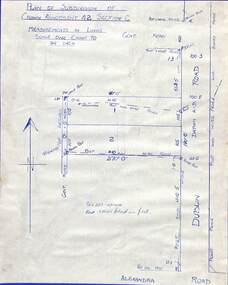 Ringwood and District Historical Society
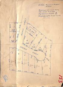
Drawing - Plan of Subdivision of Crown Allotment 42, Section C, Ringwood, Vic (Undated), Hand-drawn outline of residential allotments in Dublin Road north of Alexandra Road, Ringwood East, Victoria
... Hand-drawn outline of residential allotments in Dublin Road ...Pen drawing on cardboard backing.