Showing 148 items
matching auction lots
-
 Eltham District Historical Society Inc
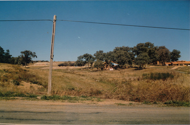
Photograph, Peter Bassett-Smith, Former Brinkkotter Poultry Farm, Main Road, Research, April 1988, 1988
... estate development of 22 lots advertised for auction 19 April... development of 22 lots advertised for auction 19 April 1988. The four ...Four colour photographs of the former Brinkkotter Poultry Farm, Main Road, Research depicting the 'Regency Acres' real estate development of 22 lots advertised for auction 19 April 1988. The four photographs are shot by Peter Bassett-Smith in a panoramic sweep of the estate from Eltham College to the Research Primary School.poultry farm, main road, research vic., brinkkotter -
 Eltham District Historical Society Inc
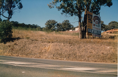
Photograph, Peter Bassett-Smith, Former Brinkkotter Poultry Farm, Main Road, Research, April 1988, 1988
... estate development of 22 lots advertised for auction 19 April... development of 22 lots advertised for auction 19 April 1988. The four ...Four colour photographs of the former Brinkkotter Poultry Farm, Main Road, Research depicting the 'Regency Acres' real estate development of 22 lots advertised for auction 19 April 1988. The four photographs are shot by Peter Bassett-Smith in a panoramic sweep of the estate from Eltham College to the Research Primary School.poultry farm, main road, research vic., brinkkotter -
 Eltham District Historical Society Inc
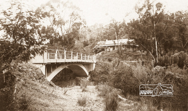
Negative - Photograph, The Bridge, Hurstbridge, Vic, c.1925
Copied from brochure "Wattle Valley Estate" 7 minutes from the bridge. The new bridge designed by Sir John Monash over the Diamond Creek near Hurst's home of 'Mia Mia' at Hurstbridge. The Wattle Valley Estate was first advertised in August 1925 as weekend building allotments by the Greater Melbourne Land and Development Company. Advertised from £28.10.0 or £60 per block. In August 1926, 30 picked allotments of 60x150 feet were put up for auction Saturday August 14, 1926 with frontages to Valley View Road and Fawkner Crescent advertised in the “Heart of the Glorious Wattle Country” and “Within 15 Minutes of the Newly Electrified Railway Station”. The Advertiser on August 13, 1926 in an article promoting the auction stated “the estate is regarded as one of the best in the district, and will be sold practically without reserve.” It is noted that an advertisement running in The Argus February 22, 1951 offered the remaining 16 blocks for sale at £12.10.0 or £200 the lot. By March 7, the remaining blocks were advertised at £17.10.0 The Wattle Valley Estate took over 20 years to sell and then people could not build on them This image was also used in a brochure advertising the "Wattle Valley Estate", which forms part of the Shire of Eltham Pioneers Photograph Collection (Cross Reference Photo No.(s): 1056, 1057)This photo forms part of a collection of photographs gathered by the Shire of Eltham for their centenary project book,"Pioneers and Painters: 100 years of the Shire of Eltham" by Alan Marshall (1971). The collection of over 500 images is held in partnership between Eltham District Historical Society and Yarra Plenty Regional Library (Eltham Library) and is now formally known as the 'The Shire of Eltham Pioneers Photograph Collection.' It is significant in being the first community sourced collection representing the places and people of the Shire's first one hundred years.Digital image 4 x 5 inch B&W Negshire of eltham pioneers photograph collection, hurstbridge, bridge, diamond creek (creek), monash bridge, wattle valley estate -
 Eltham District Historical Society Inc
Negative - Photograph, Rose Stereograph Company, The Bridge, Hurstbridge, Vic, c.1925
Copied from brochure "Wattle Valley Estate". The new bridge designed by Sir John Monash over the Diamond Creek near Hurst's original home "Mia Mia" seen in the distance. Reprinted from brochure advertising "Wattle Valley Estate" 7 minutes from bridge. The Wattle Valley Estate was first advertised in August 1925 as weekend building allotments by the Greater Melbourne Land and Development Company. Advertised from £28.10.0 or £60 per block. In August 1926, 30 picked allotments of 60x150 feet were put up for auction Saturday August 14, 1926 with frontages to Valley View Road and Fawkner Crescent advertised in the “Heart of the Glorious Wattle Country” and “Within 15 Minutes of the Newly Electrified Railway Station”. The Advertiser on August 13, 1926 in an article promoting the auction stated “the estate is regarded as one of the best in the district, and will be sold practically without reserve.” It is noted that an advertisement running in The Argus February 22, 1951 offered the remaining 16 blocks for sale at £12.10.0 or £200 the lot. By March 7, the remaining blocks were advertised at £17.10.0 The Wattle Valley Estate took over 20 years to sell and then people could not build on them This image was also used in a brochure advertising the "Wattle Valley Estate", which forms part of the Shire of Eltham Pioneers Photograph Collection (Cross Reference Photo No.(s): 1056, 1057). Also cross reference SEPP_1028 / 29 for other views of Mia Mia. Part of a slide show presentation "Bridges & Waterways of the Shire" by Russell Yeoman to the 13 September 1989 Society meeting. The presentation included slides of historic photos from the Shire of Eltham Pioneers collections as well as several recent views. This photo forms part of a collection of photographs gathered by the Shire of Eltham for their centenary project book,"Pioneers and Painters: 100 years of the Shire of Eltham" by Alan Marshall (1971). The collection of over 500 images is held in partnership between Eltham District Historical Society and Yarra Plenty Regional Library (Eltham Library) and is now formally known as the 'The Shire of Eltham Pioneers Photograph Collection.' It is significant in being the first community sourced collection representing the places and people of the Shire's first one hundred years.Digital image 4 x 5 inch B&W Negshire of eltham pioneers photograph collection, hurstbridge, mia mia, bridge, diamond creek (creek), monash bridge, wattle valley estate -
 Eltham District Historical Society Inc
Negative - Photograph, Popular Picnicing at Hurstbridge, c.1925
Picnickers enjoying a Sunday outing near the Wattle Valley Estate at Hurstbridge. Copied from brochure "Wattle Valley Estate". It is believed the picture is taken at the northwest corner of the intersection of Wattletree Road and Hurstbridge-Arthurs Creek Road looking southeast towards the township (most likely where the house is located on the property of what is today No. 2 Wattletree Road)- https://goo.gl/maps/VDorwCe1rJJUapjE6 According to a comment by Jean Verso (via @nillumbikcouncil FB page 3 Jan 2020) - "This view is from Wattle Tree Road with Haleys Gully Road to the right and across the creek to William Gray's nursery at Allwood. The building to the far left looks like Dorset House. The building on the left in the middle distance is still there today and has been used for storage and as a stable/tack room for a number of years." The Wattle Valley Estate was first advertised in August 1925 as weekend building allotments by the Greater Melbourne Land and Development Company. Advertised from £28.10.0 or £60 per block. In August 1926, 30 picked allotments of 60x150 feet were put up for auction Saturday August 14, 1926 with frontages to Valley View Road and Fawkner Crescent advertised in the “Heart of the Glorious Wattle Country” and “Within 15 Minutes of the Newly Electrified Railway Station”. The Advertiser on August 13, 1926 in an article promoting the auction stated “the estate is regarded as one of the best in the district, and will be sold practically without reserve.” It is noted that an advertisement running in The Argus February 22, 1951 offered the remaining 16 blocks for sale at £12.10.0 or £200 the lot. By March 7, the remaining blocks were advertised at £17.10.0 The Wattle Valley Estate took over 20 years to sell and then people could not build on them Cross Ref EDHS_02665 Rose Series Postcard P. 4341, "View at Hurstbridge, Vic." Also, other images from sales brochure SEPP_1055 / 1056This photo forms part of a collection of photographs gathered by the Shire of Eltham for their centenary project book,"Pioneers and Painters: 100 years of the Shire of Eltham" by Alan Marshall (1971). The collection of over 500 images is held in partnership between Eltham District Historical Society and Yarra Plenty Regional Library (Eltham Library) and is now formally known as the 'The Shire of Eltham Pioneers Photograph Collection.' It is significant in being the first community sourced collection representing the places and people of the Shire's first one hundred years.Digital image 4 x 5 inch B&W Neg1925, dorset house, fawkner crescent, haleys gully road, hurstbridge, hurstbridge-arthurs creek road, picnic, postcards, shire of eltham pioneers photograph collection, valley view road, wattle valley estate, wattletree road, exhibition yprl 2019-12 -
 Eltham District Historical Society Inc
Photograph - Postcard, Rose Stereograph Company, View at Hurstbridge, Vic, c.1925
Rose Series Postcard P. 4341 “View at Hurstbridge, Vic.” Picnickers enjoying a Sunday outing near the Wattle Valley Estate at Hurstbridge. Copied from brochure "Wattle Valley Estate". It is believed the picture is taken at the northwest corner of the intersection of Wattletree Road and Hurstbridge-Arthurs Creek Road looking southeast towards the township (most likely where the house is located on the property of what is today No. 2 Wattletree Road)- https://goo.gl/maps/VDorwCe1rJJUapjE6 According to a comment by Jean Verso (via @nillumbikcouncil FB page 3 Jan 2020) - "This view is from Wattle Tree Road with Haleys Gully Road to the right and across the creek to William Gray's nursery at Allwood. The building to the far left looks like Dorset House. The building on the left in the middle distance is still there today and has been used for storage and as a stable/tack room for a number of years." The Wattle Valley Estate was first advertised in August 1925 as weekend building allotments by the Greater Melbourne Land and Development Company. Advertised from £28.10.0 or £60 per block. In August 1926, 30 picked allotments of 60x150 feet were put up for auction Saturday August 14, 1926 with frontages to Valley View Road and Fawkner Crescent advertised in the “Heart of the Glorious Wattle Country” and “Within 15 Minutes of the Newly Electrified Railway Station”. The Advertiser on August 13, 1926 in an article promoting the auction stated “the estate is regarded as one of the best in the district, and will be sold practically without reserve.” It is noted that an advertisement running in The Argus February 22, 1951 offered the remaining 16 blocks for sale at £12.10.0 or £200 the lot. By March 7, the remaining blocks were advertised at £17.10.0 The Wattle Valley Estate took over 20 years to sell and then people could not build on them Cross Ref SEPP_1057, “Popular Picnicing at Hurstbridge” rcopied from Wattle Valley estate sales brochure.Digital file only Postcards scanned from the collection of Michael Aitken on loan to EDHS, 13 Feb 20181925, dorset house, exhibition yprl 2019-12, fawkner crescent, haleys gully road, hurstbridge, hurstbridge-arthurs creek road, michael aitken collection, picnic, postcards, rose stereograph company, shire of eltham pioneers photograph collection, valley view road, wattle valley estate, wattletree road -
 Eltham District Historical Society Inc
Photograph - Postcard, The Bridge, Hurstbridge, Vic
Arched Bridge (Monash Bridge) The Rose Series P. 4036 Reproduced in a brochure advertising the "Wattle Valley Estate" 7 minutes from the bridge. The new bridge designed by Sir John Monash over the Diamond Creek near Hurst's original home "Mia Mia" seen in the distance. The Wattle Valley Estate was first advertised in August 1925 as weekend building allotments by the Greater Melbourne Land and Development Company. Advertised from £28.10.0 or £60 per block. In August 1926, 30 picked allotments of 60x150 feet were put up for auction Saturday August 14, 1926 with frontages to Valley View Road and Fawkner Crescent advertised in the “Heart of the Glorious Wattle Country” and “Within 15 Minutes of the Newly Electrified Railway Station”. The Advertiser on August 13, 1926 in an article promoting the auction stated “the estate is regarded as one of the best in the district, and will be sold practically without reserve.” It is noted that an advertisement running in The Argus February 22, 1951 offered the remaining 16 blocks for sale at £12.10.0 or £200 the lot. By March 7, the remaining blocks were advertised at £17.10.0 The Wattle Valley Estate took over 20 years to sell and then people could not build on them.Digital file only Postcards scanned from the collection of Michael Aitken on loan to EDHS, 13 Feb 2018michael aitken collection, postcards, hurstbridge, monash bridge, bridge, diamond creek (creek), mia mia, shire of eltham pioneers photograph collection, wattle valley estate -
 Ringwood and District Historical Society
Flyer, Stillwell & Stephens Pty. Ltd, Brochure - Multiple Properties for Public Auction at Box Hill, Ringwood, Wonga Park and Clarinda - 28th November, 1934
Seven-page brochure advertising Mortgagees' Realising Sale by Public Auction on Wednesday, 28th November, 1934 for properties at Box Hill, Ringwood, Wonga Park, and Clarinda (via Oakleigh), including photographs, property descriptions, and terms of sale.Auction Commencing at 2.15 p.m. in the Orient Line Auction Rooms, 352 Collins Street, Melbourne. Solicitors: Messrs. Madden, Butler, Elder & Graham, 406 Collins Street, Melbourne. (Agents) H.P. Knight & Co. Property Salesmen and Subidivisional Experts, 315 Collins Street, Melbourne, 'Phones: Central 10615, 10616. Attractive Residential, Orchard, and Market Garden Properties, and Public Hall and School Rooms. 1. Wonga Park via Ringwood - "Holme Bush" off Warrandyte Road, Part of Lots 14 and 15, Ringwood Orchard Estate, approximatgely three miles (north) of Ringwood Railway Station - 64 Acres. 2. 17 Bishop Street, Box Hill - timber residence. 3. Greenwood Avenue, Ringwood - On East Side, 150 feet 3 inches South of Bedford Road - timber attic residence. 4. Ringwood - Wantirna Road, South-east corner of Canterbury Road - Orchard Property of approx. 11-1/2 Acres. 5. Box Hill - Whitehorse Road, South-east corner of Linsley Street - Timber building utilised as a Public Hall and Private School. 6. Clarinda vic Oakleigh, Talbot Crescent, off Centre Road - Home on 10 acres of land. -
 Ringwood and District Historical Society
Pamphlet, G.A. Green, Auction Sale Brochure - Garden Farms Estate, Ringwood, Victoria - 1919, 1919
Multi-fold brochure advertising public auction of one-acre, 2-acre, 5-acre and 8-acre allotments in Ringwood and Bayswater on Saturday 12th April, 1919. Brochure includes terms of sale, description of subdivision features and local facilities, and photographic images of the area.Subdivison includes Canterbury Road Heathmont, Armstrong Road Heathmont, Armstrong Road Bayswater, Bungalook Road Heathmont, Bungalook Road Bayswater, and Orchard Road Bayswater. Road shown as Bayswater Road to Bayswater became Mountain Highway Bayswater. Vendor: H.E.B.Armstrong, Auctioneers: Coghill & Haughton, 79 Swanston Street Melbourne, Telephone Central 2793, in conjunction with J.B. McAlpin, Ringwood, Opposite Station, Telephone Ringwood 7. (Map) Woodcock & McCormack, Civil Engineers Architects & Surveyors, 430 Little Collins Street, Melbourne, Phone 3241 Central. MOST OF THE MONEY COMES OUT OF THE LAND. And more money can be obtained from anb acre of fruit than from an acre of any other produce. But you do not have to grow fruit on Garden Farms Estate. You can go in for - Outer Suburban Home - Market Garden - Orchard - Pig Raising - Poultry Farm - Small Dairy Farm - Small Fruits - Floral Culture - Scent and Bee Farm - Or just for a Week-end Home. RINGWOOD - THE PLACE TO LIVE. The Beautiful Ringwood District has so many natural attractions, that half a Land Agent's work is done in just showing a prospective buyer round and about. Ringwood has a pull of its own that attracts folk, proved beyond doubt by its rapid development within the last decade (spite the war). First, it is high and healthy, picturesque and undulating, convenient of access, sufficiently close to the Metropolis for City and Business folk to live at Ringwood. Its development is solid, because most of its people are industrious husbandmen, real producers, who have turned idle hills into smiling gardens. These are the kind of real people to live amongst; ones who wear out their spades. The rapidly-developing town has excellent Stores, Trade and Repair Shops Churches, Banks, Telephone Exchange, Weekly General Market, Cool Stores, and good Private and State Schools, etc.; is Electrically lit, has Metropolitan Water Supply, and generally provides so that practically all shopping can be done locally. WHY RINGWOOD MUST GROW. Ringwood is a great centre and must be a greater. Two rapidly-developing railways junction here. The passengers from Ringwood Station cityward, in one year, number 250,000. Ringwood will be the terminus of the Outer Suburban Electric Eastern Railway. Its natural boundaries are the River Yarra on the North, Dandenong Creek on the South, the popular town of Croydon on the East, and the suburb of Mitcham on the West. This is a large territory that is steadily being converted from intense culture, and then it might be called (as regards its gardens) "The Devon Territory of Victoria." ARMSTRONG ROAD. This new road traverses Garden Farms Estate from its northern boundary on the main Canterbury Road, across Dandenong Creek, to its southern boundary on the main Bayswater Road, and will provide a long-desired additional link of communication between Bayswater and Ringwood. The 1-acre building sites on Bayswater Road are within 8 minutes' walk of the Bayswater Railway Station, and the Canterbury Road frontages are only 1-1/2 miles from Ringwood Station, and 1/2 mile from the Railway Station site of Canterbury Road; therefore, the whole Estate is easy of access and there should be a large demand for land so favourably placed. (Image) Cultivation Field - Potatoes on Lot 28 (Image) Picture of Bayswater Creek Flats. (Image) View from "Korumbeen" where Mr. Armstrong lived on Garden Farms Estate. Estate outlined in white ring. (Image) Site of New Bridge over Dandenong Creek. (Image) On one of the timbered lots adjoining railway. (Image) This Dandenong Creek traveres the Estate. (Image) Main Fern Tree Gully Line bisects the Estate. -
 Ringwood and District Historical Society
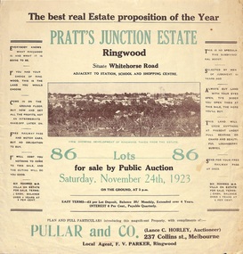
Flyer, Brochure for Land Sale By Public Auction, Pratt's Junction Estate, Ringwood, Victoria - 1923
Folded double-sided brochure advertising 86 residential lots for sale by Public Auction at 3pm, Saturday, November 24th, 1923, with town photographs, map of subdivision and summary of local features and services. Subdivision plan includes Whitehorse Road, Oliver Street, Georges Road, Junction Street, and six room weatherboard villa for sale. Local Agent - F.V. Parker, Ringwood. -
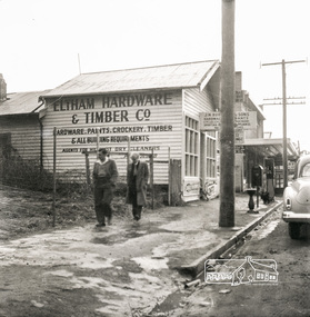 Eltham District Historical Society Inc
Photograph, Eltham Hardware and Timber Co, Main Road, Eltham, opposite Railway Station. c.1952, 1952c
The Eltham Hardware and Timber Company first opened on Main Road opposite the Railway Station around late 1922. An advertisement placed in the Hurstbridge Advertiser advised that the Hardware Store had just opened with a varied stock of Saws, Hammers, Nails, Shovels, Screw Drivers, and every article required in a house or on a farm. People were also encouraged to try their Jams, Pickles, Sauces, Cups and Saucers, etc. A few months later in May 1923, William Walker, a plumber, placed an advertisement wishing to to announce that he had taken over the ELTHAM HARDWARE STORE, and asked for the continued support of the district. He also noted that all kinds of Plumbing work was done. Walker remained the proprietor of the Hardware Store for many years regularly advertising its services and wares up until at least 1941. The trail goes a bit quiet then but he does appear in the 1944 Electoral Roll listed as a Plumber, of Main Street, Eltham. However he is not listed in the 1949 Electoral Roll but his son, Thomas Roy Walker, also a plumber of Main Road is listed. Thomas had been on active duty overseas during the Second World War and returned at the end of 1945. It is assumed that William died sometime between 1945 and 1949. On November 18th, 1950 the Hardware Store and residence was auctioned on site by Scarff Bros. Pty Ltd. It is presumed that this is when J.N. Burgoyne and Sons took over the business. It would have been around this time the picture of the store was taken for only three years later, in October 1953, the business and dwelling was again put up for sale, this time by Trebilcock Bros, in two separate lots. LOT 1. — ELTHAM HARDWARE AND TIMBER CO. Freehold and Property, Plant, Fittings and Business; Plus Stock at Valuation. To be Sold as a Going Concern. THE FREEHOLD PROPERTY Comprises Large Brick and Timber Shop. Well Fitted. Has Good Light. Comfortable 3-Room Dwelling and Detached Bungalow, H.W.S., Phone, Garage and Outbuildings. Situate on Large Allotment, 50 Ft. x 150 Ft. Aprox. THE BUSINESS: Flourishing Hardware and Builders’ Supplies, Crockery, Glassware and Gifts, Dry Cleaning Agency and Petrol Reseller Licence (1 Bowser Installed), Oil Storage. Annual Turnover Aprox. £12,000. Audited Figures Available, Old-established Business Comprehensive Stock is Good, Clean and Saleable (Value Approx. £4000). TERMS: £1000 Deposit, Balance 30 Days. VACANT POSSESSION. LOT 2. — Superb Shop Sites. Adjoining the Above Property. Land 58 Ft. x 150 Ft. (Approx.). Erected on Land Is Old Style 4-r Timber Dwelling, Set Well Back from Footpath. Leaving Ample Apace to erect Shops. Also Small Shop Let as Agent’s Office. To Be Sold Subject to Existing Tenancies, Gross Rentals £106 12/ Per Annum. Terms: £1000 Deposit, Balance 30 days. GENERAL: Eltham Is a Rapidly Developing Area only 12 Miles from G.P.O. Street Frontage of these Two Adjoining Properties Is 108 Feet By Depth of 150 Feet in the Heart of Expanding Shopping Centre, directly Opposite Station Entrance. Full Details and Inspection Available on Application from the Auctioneers: TREBILCOCK BROS. AUCTIONEERS and ESTATE AGENTS, Coincidentally, the Hardware Store was taken over by Richard Phillip Trebilcock, an electrical engineer from Mayona Road, MontmorencyNegative black and white film 120 6x6 formatSingle frameeltham, main road, 1951 chevrolet deluxe, ampol, eltham hardware and timber, j.n. burgoyne and sons, petrol bowser, william walker, richard phillip trebilcock -
 Glen Eira Historical Society
Document - LAND SUBDIVISIONS 1880-1938
This file contains various subdivisions’ advertising flyers and cards. 1/Advertising announcement for auction sale of land (15 lots) at Glenhuntly Tram Terminus, to be held on 29/03/1924. Verso is map of the area (21.5cm x 29cm) 2/Advertising announcement for Trustees’ Auction sale of corner shop sites at Caulfield South near Glenhuntly Road and Hawthorn Roads, 15/11/1927 (21cm x 31cm) 3/Advertising pamphlet (A3) for auction of Cantala Estate, East St. Kilda (32 allotments), between Dandenong, Waiora, and Alma Roads, 21/05/1938 (15.5cm x 28.5cm) 4/Seven advertising postcards relating to auctions of land in Caulfield and Elsternwick. Only one (10 December 1881) with a year on it. (Each 13.5cm x 9cm) 5/Four more advertising postcards relating to auctions of land in Caulfield. One is dated 31/11/1880(?); another 09/02/1905. A third has no date. A fourth postcard is a map of allotments between Orrong, Kooyong, Seymour and Alison Roads, Caulfield, no date (each 13.5cm x 9cm) 6/Large advertising poster (41cm x 52.5cm) for ‘Carnegie Land Sale’ auction of the Egan Estate (near Carnegie Railway Station) on 12 April, no year given, but appears to be circa1900 7/‘Riddell Estate – Plan of Subdivision – Parish of Prahran’ mounted map, no date, probably c. 1900 (16cm x 21cm)auctions, house auctions, land subdivision, land development, subdivisions, caulfield, land subdivisions, east st. kilda, glenhuntly, carnegie, map, ‘new glenhuntly tram terminus estate’, ‘cantala estate’, ‘strathnaver estate’, ‘range estate’, ‘egan estate’, ‘riddell estate’ -
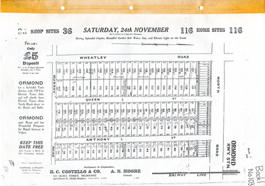 City of Moorabbin Historical Society (Operating the Box Cottage Museum)
Flyer - Brennan's Estate, Ormond - H. C. Costello & Co, 1923 - 1924
Land sales in the Municipality of Moorabbin increased when the train line from the City to Frankston was electrified. Brennan's Real Estate, Ormond 116 home sites and 36 Shop sites was auctioned on three occasions in order to sell building lots that had failed to sell at the previous action.Example of the progress of the Municipality of MoorabbinAdvertising flyers for auction of real estate sales - plan of building blocks for saleBrennan's Real Estate, Ormond 116 home sites and 36 Shop sites was auction on three occasionsnorth road, wheatley road, queen street, anthony street, murray road, h. c. costello & co, a. n. moore, ormond, real estate, auctions -
 City of Moorabbin Historical Society (Operating the Box Cottage Museum)
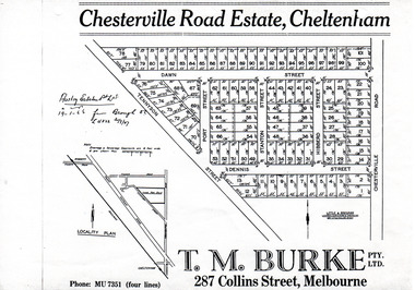
Flyer - Chesterville Road Estate, Cheltenham, 1947
Chesterville Road Estate, consisting of 101 building lots, was sold by private sale in late 1947.Example of the progress of the Municipality of MoorabbinPhotocopy of advertising flyer for sale of real estate sales - plan of building blocks for saleChesterville Road Estate, Cheltenham - plan of subdivisiontennyson street, port street, dennis street, station street, dawn street, hubbard street, chesterville road, cheltenham, real estate, auction -
 City of Moorabbin Historical Society (Operating the Box Cottage Museum)
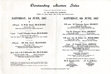
Flyer - Outstanding Auction Sales, 1957
Sale of property of the estate of Charles McCarthy Stott, a local estate agent. Example of the progress of the Municipality of MoorabbinAdvertising flyer for outstanding Auction Sales in the estate of Charles McCarthy Stott (1870-1956).Saturday 1 June 1957 - 4 properties for sale in Beaumaris - Saturday 8 June 1957 - 4 properties for sale in Highett (x2), Moorabbin, Ormondormond, 33 wells road beaumaris, 7 & 9 douglas street beaumaris, 100 oak street beaumaris, 5 & 6 balcombe road beaumaris, 34 tennyson street highett, 13 leopold st ormond, lot 93 tennyson street highett, lot 52 delma st moorabbin, auction, real estate -
 Bendigo Historical Society Inc.
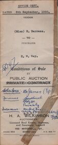
Document - H.A. & S.R. WILKINSON COLLECTION: CONDITION OF SALE
Conditions of sale by public auction issued by H.A. Wilkinson and dated 6th September 1950 between miss H. Barrass (seller) and H. W. Ray (buyer) for land situate No. 139 Queen Street Bendigo at present occupied by Mr. L.J. Lobb a tenant, being lot 1 on plan of subdivision made by Mr. A.E. Pritchard dated 13th August 1950 and being part of Crown allotment 10 section 90C, together with 5-roomed weatherboard dwelling and all sundry. Subject to existing weekly tenancy. Price 870 pounds.organization, business, h.a. & s.r wilkinson real estate -
 Bendigo Historical Society Inc.
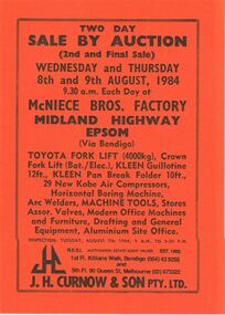
Document - IAN DYETT COLLECTION: AUCTION CATALOGUE - MCNIECE BROS FACTORY - EPSOM
Three orange covered auction catalogues with black printing for a sale on the 8th and 9th August, 1984 at McNiece Bros. Factory Midland Highway, Epsom, Via Bendigo. For sale were Fork Lifts, Guillotine, Pan Break Folder, Air Compressors, Horizontal Boring Machine, Arc Welders, Machine Tools, Stores Assort. Valves, Modern Office Machines and Furniture, Drafting and General Equipment and Aluminium Site Office. Some lots in the catalogue are underlined. J. H. Curnow & Son Pty. Ltd. Were the auctioneers.business, auctioneers, j h curnow & son pty ltd, ian dyett collection - auction catalogue - mcniece bros factory - epsom, j h curnow & son pty ltd, mr bill doxford, f c dyett, i m dyett, n f dyett, bolton bros pty ltd print -
 Bendigo Historical Society Inc.
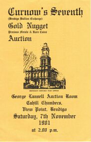
Document - IAN DYETT COLLECTION: AUCTION CATALOGUE - CURNOW'S SEVENTH GOLD NUGGET PRECIOUS METALS
Yellow catalogue with black printing for Curnow's Seventh Gold Nugget Precious Metals & Rare Coins Auction held in the George Lansell Auction Room, Cahill Chambers, View Point, Bendigo on 7th November 1981. On the front is a black sketch of Bendigo's Historic Post Office. The inside contains a list of Nuggets with Lot No., Approx. Weight in Grams, Area of Find, Code, Why Buy Gold?, and List of Coins. Also note to buyers. The left front has the Conditions of Sale and the centre front has Curnows name and a Reproduction of Curnows original Letterhead circa 1900. Sale includes nuggets from Wedderburn, Tarnagulla, Rheola, Inglewood, Maryborough, Bendigo, Dunolly and Eaglehawk.business, auctioneers, j h curnow & son pty ltd, ian dyett collection - auction catalogue - curnow's seventh gold nugget precious metals & rare coins auction, bolton bros pty ltd, j h curnow, j h curnow & son pty ltd, ian dyett, fred dyett -
 Bendigo Historical Society Inc.
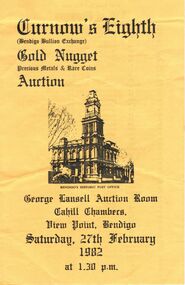
Document - IAN DYETT COLLECTION: AUCTION CATALOGUE - CURNOW'S EIGHTH GOLD NUGGET PRECIOUS METALS
Yellow catalogue with black printing for Curnow's Eighth Gold Nugget Precious Metals & Rare Coins Auction held in the George Lansell Auction Room, Cahill Chambers, View Point, Bendigo on 27th February 1982. On the front is a black sketch of Bendigo's Historic Post Office. The inside contains a list of Nuggets with Lot No., Approx. Weight in Grams, Area of Find, Code, Stone from Brazil, some jewellery and List of Coins. The left front has the Conditions of Sale and the centre front has Curnows name and a Reproduction of Curnows original Letterhead circa 1900. Sale includes nuggets from Tarnagulla, Bendigo, Maryborough, Inglewood and Myrtleford.business, auctioneers, j h curnow & son pty ltd, ian dyett collection - auction catalogue - curnow's eighth gold nugget precious metals & rare coins auction, bolton bros pty ltd, j h curnow, j h curnow & son pty ltd, ian dyett, fred dyett -
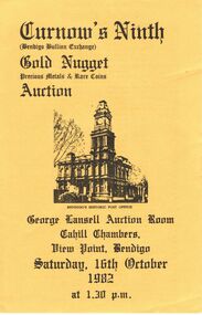 Bendigo Historical Society Inc.
Document - IAN DYETT COLLECTION: AUCTION CATALOGUE - CURNOW'S NINTH GOLD NUGGET PRECIOUS METALS
Yellow catalogue with black printing for Curnow's Ninth Gold Nugget Precious Metals & Rare Coins Auction held in the George Lansell Auction Room, Cahill Chambers, View Point, Bendigo on 16th October 1982. On the front is a black sketch of Bendigo Historic Post Office. The inside contains a list of Nuggets with Lot No., Approx. Weight in Grams, Area of Find, Code, Why Buy Gold? And Note to Buyers. The left front has the Conditions of Sale and the centre front has Curnows name and a Reproduction of Curnows original Letterhead circa 1900. Sale includes nuggets from Victoria and Interstate.business, auctioneers, j h curnow & son pty ltd, ian dyett collection - auction catalogue - curnow's ninth gold nugget precious metals & rare coins auction, bolton bros pty ltd, j h curnow, j h curnow & son pty ltd, ian dyett, fred dyett -
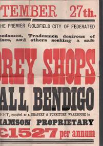 Bendigo Historical Society Inc.
Document - BUILDINGS FOR SALE BENDIGO, Fri.27 Sep 1861-1878
Document, Buildings For Sale in Bendigo C.B.D. Could be in these years 1861-1878, Friday 27th September. 4 two storey shops in the very heart of Pall Mall Bendigo also extensive premises in William St occupied as a Drapery & furniture Warehouse by Messrs Craig , Williamson Proprietary producing total rental of 1527 pounds per annum . .Maurice Moran co …to sell by public auction ..the whole of the property in the estate of the late Gavin Gibson …lot 1 Pall Mall -two brick shops occupied by Mr C.W. Hyett , Bookseller and 2 Mr John Lay Chemist (3) suite of offices let to Mr John Lay Dentist … Solicitors -Messrs Snowden , Neave and Demaine , chancery and Melbourne …Maurice Moran & co Williamson St Bendigo … J.B. Young Printer . Lithographer Bendigo……. The document appears to be circa 1888 ---(27.9.1888 ?) after Gibson's death in 1888J.B.Young, Printer, Lithographer, &c, Bendigo.document, newspaper, bendigo theme -
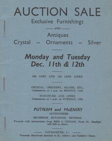 Bendigo Historical Society Inc.
Document - LYDIA CHANCELLOR COLLECTION: AUCTION CATALOGUE C. CONLON, NEALE ST, BENDIGO
Blue cover, black text auction catalogue. On front cover: Auction Sale, 11th, and 12th., December. 500 lots and 150 lots linen. Crystal, crockery, silver, etc. Putnam and McEniry, Auctioneers, Shamrock Buildings, Bendigo. Favoured with instrucgtion from Miss C. Conlon, Neale Street, Bendigo. Proceeds therefrom donated to St. Aiden's and Toddlers' Home.bendigo, business, putnam and mceniry -
 Whitehorse Historical Society Inc.
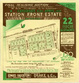
Document, Station Front Estate, 1940
Brochure advertising auction of 'Station Front estate'Brochure advertising auction of 'Station Front estate', Mitcham. 22 lots, 13 April 1940. Auctioneers Edward Haughton Pty Ltd, Drake & Co. Printed in two colours.Brochure advertising auction of 'Station Front estate'station front estate, auctions, calcutta street, mitcham, simla street, benares street, delhi street, mitcham road -
 Whitehorse Historical Society Inc.
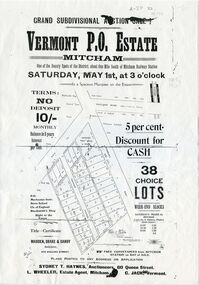
Document, Vermont P.O. Estate, 1926 0r 1915
Brochure advertising auction of Vermont P.O. EstateBrochure advertising auction of Vermont P.O. Estate, 38 lots, 1 May 1920. Auctioneers: Sydney T. Haynes, L. Wheeler, C. Jack.Brochure advertising auction of Vermont P.O. Estateauctions, vermont post office estate, canterbury road, vermont, boronia road, frances avenue -
 Whitehorse Historical Society Inc.
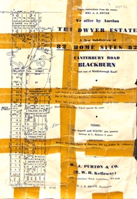
Pamphlet - Advertising brochure, Dwyer Estate, 1951
Brochure advertising auction of 'Dwyer Estate', Canterbury Road, Blackburn. 82 lots, 17 November 1951. Agents: W.J. Purtonauctions, canterbury road, blackburn, pakenham street, doogan street, kalang street, orana street, dwyer street, dwyer estate, dwyer, a.a. (mrs), garie street, h. j. d. bruce -
![Brochure for auction of Eastdawn Estate, Mitcham, 70 lots [20 February 1915]](/media/collectors/56f368632162f118acbff12e/items/60d923316e5f99545134e472/item-media/60d9477c6e5f995451350fb8/item-fit-380x285.jpg) Whitehorse Historical Society Inc.
Whitehorse Historical Society Inc.Document, Eastdawn Estate, 1915
Brochure for auction of Eastdawn Estate, Mitcham, 70 lots [20 February 1915]Brochure for auction of Eastdawn Estate, Mitcham, 70 lots [20 February 1915]. Agents Coghill & Haughton.Brochure for auction of Eastdawn Estate, Mitcham, 70 lots [20 February 1915]auctions, eastdawn estate, mother foster's estate, mitcham road, mitcham, orient avenue, hull parade, vernal avenue -
Whitehorse Historical Society Inc.
Letter - Correspondence, Abattoir Property, 1937
Letter between City of Box Hill and Shire of Blackburn and Mitcham re sale of Lot 2, Abattoir Estate. A plan of subdivision and list of allotments for auction by City of box Hill on 27 Oct 1937.Letter between City of Box Hill and Shire of Blackburn and Mitcham re sale of Lot 2, Abattoir Estate. A plan of subdivision and list of allotments for auction by City of box Hill on 27 Oct 1937.Letter between City of Box Hill and Shire of Blackburn and Mitcham re sale of Lot 2, Abattoir Estate. A plan of subdivision and list of allotments for auction by City of box Hill on 27 Oct 1937.land sales, city of box hill, shire of blackburn and mitcham, abattoirs paddock, aspinalls estate, woodhouse grove, box hill north, koonung creek, bishop, herbert thomas -
 Whitehorse Historical Society Inc.
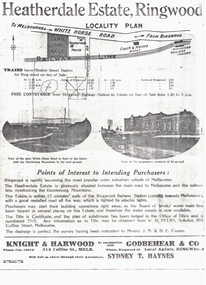
Document, Heatherdale Estate, Ringwood, 1919
Brochure advertising 52 lots, Heatherdale Estate, Ringwood (now Mitcham) to be auctioned September 1919.Brochure advertising 52 lots, Heatherdale Estate, Ringwood (now Mitcham) to be auctioned September 1919. Station Street on the plan is now Victory Street and a Railway Avenue is shown which does not now exist.Brochure advertising 52 lots, Heatherdale Estate, Ringwood (now Mitcham) to be auctioned September 1919.land subdivision, heatherdale estate, whitehorse road, mitcham, melbourne and metropolitan board of works, peers, w.h., coane, j.m., h.e., knight & harwood, godbehear & co, haynes, sydney t, walter street, witt street, victory street, purches, frederick walter -
 Whitehorse Historical Society Inc.
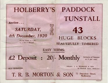
Pamphlet, Holberry's Paddock Tunstall, 1920
Article on development of 30 lot subdivision of former Blackburn East Primary School SiteAuction of Holberry's Paddock, Tunstall - 43 blocks, 4 December 1920. Includes plan.Article on development of 30 lot subdivision of former Blackburn East Primary School Siteshady grove, nunawading, mount pleasant road, holberry street, t. r. b. morton & son, auctions, forest hill holberrys paddock, tunstall