Showing 84 items
matching barkly place
-
 Orbost & District Historical Society
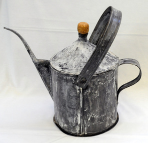
poison pot, Smith, R. & E, 1940's
This item was used on P.C. Toby Nixon and Grace Nixon's farm, "Rolling Downs" at Bete Bolong. During WW11 the farm grew carrots, red beet, cabbages, beans and maize. Because of labour shortages the government built a Prisoner of War Camp on Russell's Hill. The manager, Dick Northrope, used three Italian prisoners to frill ring small trees and shrubs between crop harvesting. The introduction of ‘frill ringing’ and poisoning with arsenical tree killers in the 1940's and 1950's helped reduce the amount of labour required and trees on more country were treated. This enabled the hill country at Bete Bolong to become more productive. The dead trees and shrubs were later cleared by Erle Broome's D7 caterpillar bulldozer. This was the first big area of 230 acres to be cleared in the Orbost district. Soon after entering World War 11 Australia was asked by Britain to accept and guard large numbers of 'enemy aliens' and prisoners of war. The British government felt that it could not afford to feed large numbers of prisoners and it was believed that once in Australia the internees would have no chance of escape. Eager to show solidarity with Britain's cause, Australia readily agreed and decided to place the prisoners in a number of different camps scattered around the country and guard them with reservists and soldiers too unfit to serve overseas. There was an internment camp at Bete Bolong, Orbost. This item is an example of an item used by the Italian P.O.W.'s residing there. It is also an example of an agricultural tool not commonly used today.A galvanized iron watering can which has been used to hold poison for ring barking trees (possibly arsenic). It has a narrow spout. There is a handle at the back and a folding handle on the top. The top is conical with an opening for a cork. agriculture prisoner-of-war-camp tree-removal land-clearing -
 Orbost & District Historical Society
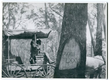
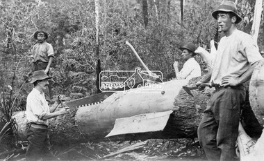
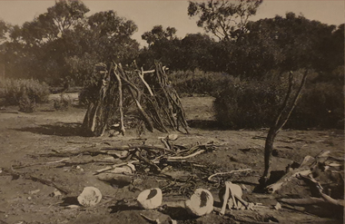
black and white photograph, 1913
When marking a boundary for a registered plan, a surveyor would place “Reference Marks” with a stated bearing and distance to a boundary corner. These trees were typically marked by cutting the bark of the tree in a shield or blaze. Until July 1886, surveyors were only able to use trees as reference marks to boundary corners. After July 1886 surveyors were able to use “permanent marks” which were either a glass bottle, gas pipe or iron bolt (for homestead surveys only). This photograph shows the reference tree, 83 miles from Marlo via the original surveyed road v ia Sydenham Inlet and Tamboon, south of Mount Drummer to the New South Wales border - now the Princes Highway.This is a pictorial record of an old survet tree. Knowledge of their location, abundance and condition not only provide important insights to past survey practice, but also provide a lasting legacy of a regions land-use history. Old survey trees serve as one of the few remaining physical legacies of early European land settlement history.A large black / white photograph of a horse and buggy pulled up alongside a reference tree which has notches and markings of Roman numerals.on back - " Refernce tree 83 miles from Marlo........to N.S.W. Border"survey-tree reference-tree -
 Eltham District Historical Society Inc
Photograph - Digital Photograph, Alan King, Pigeon Bank, one of the Nillumbik shire's oldest farm dwellings, 6 February 2008
In 1848, Francis Rogerson form Dumfriesshire, Scotland purchased 80 acres of land at Kangaroo Ground on which he built a two-roomed bark hut. He named the property afterr the many Bronzewings and Wonga Pigeons in the area. Ewen Hugh Cameron moved to Pigeon Bank the same year he was elected to Parliament as the Member for Evelyn. At the time he moved in, Pigeon Bank had six rooms and the present water well. He made further extensive additions and lived there until his death in 1915. Covered under Heritage Overlay, Nillumbik Planning Scheme. Published: Nillumbik Now and Then / Marguerite Marshall 2008; photographs Alan King with Marguerite Marshall.; p27This collection of almost 130 photos about places and people within the Shire of Nillumbik, an urban and rural municipality in Melbourne's north, contributes to an understanding of the history of the Shire. Published in 2008 immediately prior to the Black Saturday bushfires of February 7, 2009, it documents sites that were impacted, and in some cases destroyed by the fires. It includes photographs taken especially for the publication, creating a unique time capsule representing the Shire in the early 21st century. It remains the most recent comprehenesive publication devoted to the Shire's history connecting local residents to the past. nillumbik now and then (marshall-king) collection, ewen hugh cameron, francis rogerson, kangaroo ground, kangaroo ground-warrandyte road, pigeon bank -
 Eltham District Historical Society Inc
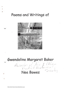
Document - Folder, Poems and writings of Gwendoline Margaret Baker, nee Bowes, 1997
Various short pieces of writing, some dated, earliest 1971, latest in 1997. Gwen Baker (1928-2005) was a foundation member of EDHS. See Also Newsleter 162, May 2005 GWENDOLINE MARGARET BAKER NEE BOWES 1928- 2005 Gwen Baker as we knew her, often used her full name in her writings and even acknowledged her maiden family name as a means of reinforcing her own personal identity. Gwen died on 28 Februrary 2005 and has been buried at Arthurs Creek Cemetery in accordance with her wishes. It is typical of her humour that after visiting the site she wrote: "I have seen the Cemetery, so if I wake in sleep it has a nice view" Gwen was a foundation member of our Society. We remember her mainly for her contribution to our meetings, her witty comments or questions to our speakers and, of course, her collection of plants that she contributed to help the finances of our Society. Her friends in the Society also remember her cards and brief letters on a wide range of subjects. Gwen's wide range of interests included pottery, poetry and of course her gardening. She was an active member of many organizations including the Red Cross, Catholic Church, Nillumbik Garden Club and the former Eltham Arts Council. Her small self- published booklet of poems and writings starts with tins item written at 2am on Easter Sunday 1975. THOUGHT The seeming steady stillness of this quiet night has varied sound to one who sits and thinks of life. Of times of your of pleasant things and if the future has in store a place to be - a reason to exist. One hears a bird upon the roof scratching at his mate while in the distance a car goes by returning home quite late. A neighbours dog goes forth and bark! then stillness once again, like sunshine after rain. and so the thinker having heard and thought, carefully turns out the light and goes to bed. 41 pages (20 A4 pages cut in half). Folder 76 from Harry Gilham Collectionpoetry, creative writing, gwen baker -
 Shepparton RSL Sub Branch
Light Horse Tent Pegging number 5 ??, c.ww1
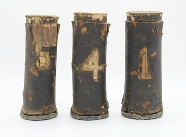
Any further information great fully accepted Wooden shaft bark covered with lead base held in place with small brass tacks figure 5 cut out of leatherFigure 5light horse, tent pegging -
 Shepparton RSL Sub Branch
Light Horse Tent Pegging number 1 ??
wooden bark covered tent pegging marker with lead base held in place with small brass tacks and figure 1Figure 1 -
 Seaworks Maritime Museum
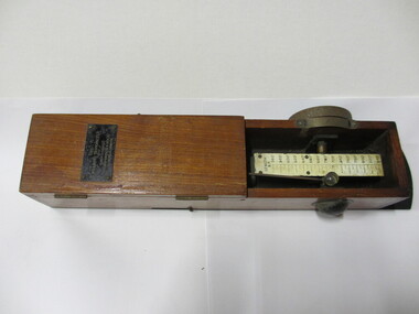
Williams Trimometer, Henry Browne & Son, London
Rectangular open box with doweled edges. Measuring instruments are visible inside, as well as a pendulum that still moves. Two metal knobs located on the outside of the box. ‘The/WILLIAMS TRIMOMETER/ No 57/MANUFACTURED BY HENRY BROWNE & SON LTD/BARKING & LONDON’ -
 Mission to Seafarers Victoria
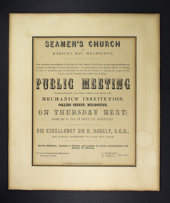
Poster - Notice of meeting, Public Meeting - 25 February 1858, 1858
Notice advertising a public meeting taking place on 1858 and regarding a Seamen's church, Hobson's Bay, Melbourne . The Governor, Sir Henry Barkly, KCB, chaired the meeting. Captain Charles Ferguson (died in 1868) was the harbourmaster of the Port of Melbourne, and previously the captain of the barque Rajah.Example of poster of very early Melbourne public meeting "of persons interested in the welfare of sailors". Demonstrates beginnings of Melbourne-based organisation and support for seafarers. Small paper poster with mixed/ornate text, housed within two cardboard frame mats, front window frame mat cut to size of poster see imageseaman's church, hobson's bay, mechanics institute, governor, sir henry barkly, w. fairfax, friends of the sailor, sandridge, port melbourne, seamen's mission, mission to seafarers, mission to seamen, captain charles ferguson -
 Halls Gap & Grampians Historical Society
Newspaper - Photocopy
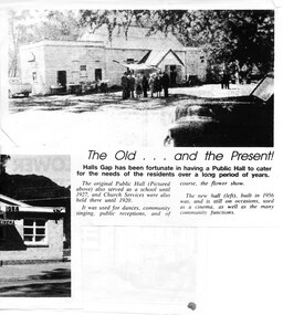
The article shows a photo of the original Hall's Gap Hall and the (then) new Hall, which was built in 1956. The copy has been scanned as two separate images (because it was too large for the scanner). the second image is stored under "Additional Images". HISTORY OF HALL'S GAP HALL: No village, no matter how small, could possibly survive without a public meeting place, and Hall's Gap was no exception, even in 1899-1900. Actually it was the locals of Stony Creek village, as Hall's Gap was known for a short time, who decided to hold a meeting to find out how much interest there was in building a town hall! They soon found out that support was overwhelming, as can be seen by the fact that 14 gentlemen nominated for a position on the committee of four! Several motions were moved at that meeting, mainly with reference to the materials to be used, for instance that no "wattle and daub", but rather slabs of bark and local bush logs be used. The walls were to be constructed of slabs, 6 feet long, 9 inches wide and two inches thick. Uprights were to be 9 feet high and at least 9 inches thick. Sheets of bark, all 32 of them, had to be 8 feet by 8 feet. Tenders for the building materials were called on 9 March 1899 and, 21 days later, McKeon Brothers won the right to supply all the material for the princely sum of 4 pounds 10 shillings. The size of the hall was to be 20 feet by 10 feet. The first hall served the community well for the next thirteen years, being regularly used as a place of entertainment and religious worship. The growing community soon realised the need for a larger venue, with better facilities, so once again the townsfolk rallied to raise funds for a new hall, realising their dream around 1913. In 1921 a schoolteacher was provided by the education department but as there was no school building she was expected to use the hall. Mainly lessons were held in the kitchen as it was much warmer than the hall itself, and it was not unusual for up to twenty children to be taught, ranging in age from 5 to 14 years. It was not until 1928 that an official school was built. 1955-56 were years of great excitement. The Progress Association was in charge of deciding the format for the new hall, and there were many rowdy meetings beforehand. Some members had much more vision than others, and to some the amount of money required seemed astronomical. Two hall committee members resigned over differences of opinion but amazingly it all came together in the end, albeit at a greater cost than had been anticipated. There is only one record of a grant being made for the building,1500 pounds, and it came for the Minister of Public Works. Estimated cost of the building was around 8,000 pounds, and when finally finished it was just slightly over, but bank charges and interest took it to well over 9,000 pounds. An electric light generator was included and lighting installed. The SEC electricity was connected in 1962.A copy of a newspaper article entitled 'The Old . . . and the Present!', which includes two photographs.buildings, halls -
 Eltham District Historical Society Inc
Photograph, Cutting timber for Browns Mill, Kinglake District
Loggers from Brown's Mill, Kinglake use a hand saw to remove bark and split a tree trunk after its felling in the Kinglake forest. Circa 1923.This photo forms part of a collection of photographs gathered by the Shire of Eltham for their centenary project book, "Pioneers and Painters: 100 years of the Shire of Eltham" by Alan Marshall (1971). The collection of over 500 images is held in partnership between Eltham District Historical Society and Yarra Plenty Regional Library (Eltham Library) and is now formally known as 'The Shire of Eltham Pioneers Photograph Collection.' It is significant in being the first community sourced collection representing the places and people of the Shire's first one hundred years.Digital imagesepp, shire of eltham pioneers photograph collection, kinglake, browns mill, logging, loggers, lumber trade, brown's mill, kingake national park, forest, bush -
 Eltham District Historical Society Inc
Photograph, Slab hut, Warrandyte, Warrandyte Mystery Tour, 29 May 1994, 29/05/1994
[article by Bettina Woodburn in EDHS Newsletter No. 97, July 1994:] THE WARRANDYTE MYSTERY TOUR MAY 29TH 1994 - Members of the Eltham Historical Society met at the Old Post Office, now converted into the Warrandyte Historical Museum, for a picnic lunch on the sunny back verandah overlooking the shimmering Yarra River. Interesting photographs and artefacts filled various rooms outlining the history of this area, and told tales of Aboriginal and more recent neighbours of the Eltham Shire. The weather was calm, cloudy mostly with only occasional sunny patches, but it wasn't cold, although the autumnal leaf colours had changed to wintry brown. "All Aboard" and we set off in the Warrandyte Community Bus (with the School Bus sign displayed at the rear) to learn about local places of "Pride and Joy” from Bruce our guide and Tom the driver. Almost directly opposite we entered Whipstick Gully to explore the first of the district's hidden treasures - the Victory, one of the largest of the six or so major mines, past the old quarry now used for abseiling practice. By torchlight we entered the rocky hillside and saw the seams of quartz the miners had followed in their search for gold. Stamping batteries, and there was one in this gully, converted discarded rock into 'road metal'. Warrandyte is proud to be the first declared Goldfield in 1851, and one of the longest surviving, into the 1920s. A pleasant drive across the Bridge and along Bradley's Lane to Norman's Reserve brought us to see another Tunnel at Pound Bend through which the Yarra was diverted to allow about three miles of river-bed to be used for prospecting for alluvial gold. Still on this side of the river we visited the Old Slab Hut in Castles Road. This remnant of miners' housing is preserved because it had been incorporated into a weatherboard house, and saved from the bulldozers - a last minute reprieve, for preservation, by the National Trust. Devastating bush fires have destroyed other old cottages built of wattle and daub, with bark roofs and stone fire-places. The Cairn commemorating the disclosure of Gold Discovery at Warrandyte on June 30th 1851 beside Anderson's Creek Road was our next point of historical interest. We drove on to South Warrandyte and circled back to above the ford on Anderson's Creek to the entrance of the 4th Hill Mine. Again we crept along with our torches, careful of the low roof-rock, and side shafts. At a junction in a large cavity we were able to stand, look up a long air-vent which some 'cavers' climb down, and marvel at, and experience an aspect of a miner's life. Outside we heard the same bird songs, the trills and bell-pealing, saw the same straggly eucalypts, and a silver leafed wattle in flower, native grasses and ferns, and the neat present day houses, often of Warrandyte stone, perhaps veneered only. The day ended pleasantly, seeing more of the Yarra from Everard Drive, and the water rushing out of the Tunnel at Pound Bend, before returning to afternoon tea or coffee at the Museum. A great day for all concerned - many thanks to the Organisers.Colour photographslab hut, warrandyte, "warrandyte miner's cottage" -
 Eltham District Historical Society Inc
Photograph, Pound Bend tunnel, Warrandyte, Warrandyte Mystery Tour, 29 May 1994, 29/05/1994
[article by Bettina Woodburn in EDHS Newsletter No. 97, July 1994:] THE WARRANDYTE MYSTERY TOUR MAY 29TH 1994 - Members of the Eltham Historical Society met at the Old Post Office, now converted into the Warrandyte Historical Museum, for a picnic lunch on the sunny back verandah overlooking the shimmering Yarra River. Interesting photographs and artefacts filled various rooms outlining the history of this area, and told tales of Aboriginal and more recent neighbours of the Eltham Shire. The weather was calm, cloudy mostly with only occasional sunny patches, but it wasn't cold, although the autumnal leaf colours had changed to wintry brown. "All Aboard" and we set off in the Warrandyte Community Bus (with the School Bus sign displayed at the rear) to learn about local places of "Pride and Joy” from Bruce our guide and Tom the driver. Almost directly opposite we entered Whipstick Gully to explore the first of the district's hidden treasures - the Victory, one of the largest of the six or so major mines, past the old quarry now used for abseiling practice. By torchlight we entered the rocky hillside and saw the seams of quartz the miners had followed in their search for gold. Stamping batteries, and there was one in this gully, converted discarded rock into 'road metal'. Warrandyte is proud to be the first declared Goldfield in 1851, and one of the longest surviving, into the 1920s. A pleasant drive across the Bridge and along Bradley's Lane to Norman's Reserve brought us to see another Tunnel at Pound Bend through which the Yarra was diverted to allow about three miles of river-bed to be used for prospecting for alluvial gold. Still on this side of the river we visited the Old Slab Hut in Castles Road. This remnant of miners' housing is preserved because it had been incorporated into a weatherboard house, and saved from the bulldozers - a last minute reprieve, for preservation, by the National Trust. Devastating bush fires have destroyed other old cottages built of wattle and daub, with bark roofs and stone fire-places. The Cairn commemorating the disclosure of Gold Discovery at Warrandyte on June 30th 1851 beside Anderson's Creek Road was our next point of historical interest. We drove on to South Warrandyte and circled back to above the ford on Anderson's Creek to the entrance of the 4th Hill Mine. Again we crept along with our torches, careful of the low roof-rock, and side shafts. At a junction in a large cavity we were able to stand, look up a long air-vent which some 'cavers' climb down, and marvel at, and experience an aspect of a miner's life. Outside we heard the same bird songs, the trills and bell-pealing, saw the same straggly eucalypts, and a silver leafed wattle in flower, native grasses and ferns, and the neat present day houses, often of Warrandyte stone, perhaps veneered only. The day ended pleasantly, seeing more of the Yarra from Everard Drive, and the water rushing out of the Tunnel at Pound Bend, before returning to afternoon tea or coffee at the Museum. A great day for all concerned - many thanks to the Organisers.Two colour photographswarrandyte, activities, pound bend -
 Marysville & District Historical Society
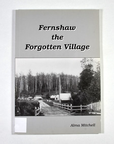
Book - Paperback book, Alma Mitchell, Fernshaw the Forgotten Village, 2001
The story of the village of Fernshaw between the dates of 1864 and 1890.Paperback. Front cover has the title and author's name. Also, a black and white photograph taken by John W. Lindt entitled 'First Glimpse of Fernshaw'.non-fictionThe story of the village of Fernshaw between the dates of 1864 and 1890.fernshaw, victoria, history, watts river, yarra track -
 Marysville & District Historical Society
Book - Paperback book, Alma Mitchell, Fernshaw the Forgotten Village, 2001
The story of the village of Fernshaw between the dates of 1864 and 1890.Paperback. Front cover has the title and author's name. Also, a black and white photograph taken by John W. Lindt entitled 'First Glimpse of Fernshaw'.non-fictionThe story of the village of Fernshaw between the dates of 1864 and 1890.fernshaw, victoria, history, watts river, yarra track -
 Federation University Historical Collection
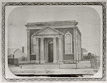
Photograph - Black and White, Ballarat Synagogue, 1861
The Ballarat Synagogue was built in 1861 and regarded as a highly orthodox synagogue in its early years. It is one of the few surviving nineteenth century synagogues in Victoria and is one of the oldest still operating on the mainland of Australia. (http://www.dpcd.vic.gov.au/__data/assets/pdf_file/0007/36862/ballarat_synagogue.pdf)Black and white photograph of a brick building in Barkly Street, Ballarat East. The building is known as the Ballarat Synagogue. It is a place or worship for the Ballarat Hebrew Congregation.ballarat, synagogue, religion, hebrew, jewish, 1861 -
 Bendigo Historical Society Inc.
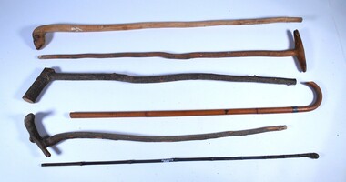
Accessory - Walking canes
Six walking canes shaped from natural timber. 7543a Light coloured wood with top carved in shape of a snake head. 7543b Light brown wood with T shape carved top. 7543c Dark brown branch with bark intact. Natural branch at 30 degrees cropped at top. 7543d Thin dark brown bamboo like straight walking stick. Ornate carved knob at top. 7543e Light brown straight walking stick of three pieces of wood spliced together. Curved top spliced in place. Lacquered and polished. Metal band attached below hand grip (1.5 cm wide.) 7543f Rough natural branch with natural handle at 30 degrees angle.walking sticks, wooden objects, natural wood -
 Bendigo Historical Society Inc.
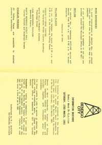
Document - BENDIGO CITY INFORMATION BROCURE BARKLY WARD, 23 March 1991
Bendigo City Information Brochure Barkly Ward By-Election. Saturday, 23rd March, 1991. Brochure by the Bendigo City Council to assist Barkly Ward residents in casting their vote in Barkly Ward, 23 March, 1991. Authorised by R J Burton, Returning Officer. Map of Barkly Ward. Candidate Information, Lois Angus, David Anderson, Lynne Geri. Ward Boundaries. Hotline. Polling places: Senior Citizens Centre (Bendigo), White Hills Primary School, Lake Weeroona Pavilion, North Bendigo Scout Hall. Disabled Persons all Polling Places are accessible to disabled persons in wheelchairs.government, local, barkly ward, bendigo city information brochure barkly ward by-election. saturday, 23rd march, 1991. 23 march, 1991. authorised by r j burton, returning officer. map of barkly ward. candidate information, lois angus, david anderson, lynne geri. ward boundaries. hotline. polling places: senior citizens centre (bendigo), white hills primary school, lake weeroona pavilion, north bendigo scout hall. all polling. accessible to disabled -
 Bendigo Historical Society Inc.
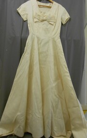
Clothing - MERLE HOULDEN COLLECTION: WEDDING DRESS, 06-02-1960
Merle made her own dress,as she had been a Home Economics Teacher, specializing in dressmaking. Dress is of silk chiffon, over tree bark satin, made on princess lines, with a Dior bow at the neckline. The brief sleeved bodice was cut with an oval neckline, trimmed with a flat bow. Fullness for the circular skirt was drawn to the back of the seven panel dress. A watteau pleat, train of embroidered nylon fell from high at the back of the bodice (refer 11400.493). A short tulle veil was held in place by a triple Dior bow. Skirt extends to a small train at back.Refer 11400.492.costume, female, wedding dress -
 Bendigo Historical Society Inc.
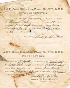
Document - ANCIENT ORDER OF FORESTERS NO. 3770 COLLECTION: CORRESPONDENCE
A.O.F., Court King of the Forest, No. 3770, B.U.D. Notice of Intention and Proposition. I hereby give notice of Intention to Propose Mr. Thomas White, age 28 years, Occupation Blacksmith, Place of Birth England, residence Iron Bark, Wife's Name Margaret Age 26 years, No of Children 1. Signature Rich Coath. The Proposition - Proposed by R. J. Coath and Seconded by Ed. Le Levies. Mr Thomas White as a Candidate for admission. Proposed by R. J. Coath and Seconded by Ed. Le Levies.societies, aof, correspondence, ancient order of foresters no. 3770 collection - correspondence, court king of the forest, thomas white, margaret white, rich coath, ed le levies -
 Victorian Aboriginal Corporation for Languages
Periodical, Australian Institute of Aboriginal and Torres Strait Islander Studies, Australian Aboriginal studies : journal of the Australian Institute of Aboriginal and Torres Strait Islander Studies, 2008
1. Rock-art of the Western Desert and Pilbara: Pigment dates provide new perspectives on the role of art in the Australian arid zone Jo McDonald (Australian National University) and Peter Veth (Australian National University) Systematic analysis of engraved and painted art from the Western Desert and Pilbara has allowed us to develop a spatial model for discernable style provinces. Clear chains of stylistic connection can be demonstrated from the Pilbara coast to the desert interior with distinct and stylistically unique rock-art bodies. Graphic systems appear to link people over short, as well as vast, distances, and some of these style networks appear to have operated for very long periods of time. What are the social dynamics that could produce unique style provinces, as well as shared graphic vocabularies, over 1000 kilometres? Here we consider language boundaries within and between style provinces, and report on the first dates for pigment rock-art from the Australian arid zone and reflect on how these dates from the recent past help address questions of stylistic variability through space and time. 2. Painting and repainting in the west Kimberley Sue O?Connor, Anthony Barham (Australian National University) and Donny Woolagoodja (Mowanjum Community, Derby) We take a fresh look at the practice of repainting, or retouching, rockart, with particular reference to the Kimberley region of Western Australia. We discuss the practice of repainting in the context of the debate arising from the 1987 Ngarinyin Cultural Continuity Project, which involved the repainting of rock-shelters in the Gibb River region of the western Kimberley. The ?repainting debate? is reviewed here in the context of contemporary art production in west Kimberley Indigenous communities, such as Mowanjum. At Mowanjum the past two decades have witnessed an artistic explosion in the form of paintings on canvas and board that incorporate Wandjina and other images inspired by those traditionally depicted on panels in rock-shelters. Wandjina also represents the key motif around which community desires to return to Country are articulated, around which Country is curated and maintained, and through which the younger generations now engage with their traditional lands and reach out to wider international communities. We suggest that painting in the new media represents a continuation or transference of traditional practice. Stories about the travels, battles and engagements of Wandjina and other Dreaming events are now retold and experienced in the communities with reference to the paintings, an activity that is central to maintaining and reinvigorating connection between identity and place. The transposition of painting activity from sites within Country to the new ?out-of-Country? settlements represents a social counterbalance to the social dislocation that arose from separation from traditional places and forced geographic moves out-of-Country to government and mission settlements in the twentieth century. 3. Port Keats painting: Revolution and continuity Graeme K Ward (AIATSIS) and Mark Crocombe (Thamarrurr Regional Council) The role of the poet and collector of ?mythologies?, Roland Robinson, in prompting the production of commercial bark-painting at Port Keats (Wadeye), appears to have been accepted uncritically - though not usually acknowledged - by collectors and curators. Here we attempt to trace the history of painting in the Daly?Fitzmaurice region to contextualise Robinson?s contribution, and to evaluate it from both the perspective of available literature and of accounts of contemporary painters and Traditional Owners in the Port Keats area. It is possible that the intervention that Robinson might have considered revolutionary was more likely a continuation of previously well established cultural practice, the commercial development of which was both an Indigenous ?adjustment? to changing socio-cultural circumstances, and a quiet statement of maintenance of identity by strong individuals adapting and attempting to continue their cultural traditions. 4. Negotiating form in Kuninjku bark-paintings Luke Taylor (AIATSIS) Here I examine social processes involved in the manipulation of painted forms of bark-paintings among Kuninjku artists living near Maningrida in Arnhem Land. Young artists are taught to paint through apprenticeships that involve exchange of skills in producing form within extended family groups. Through apprenticeship processes we can also see how personal innovations are shared among family and become more regionally located. Lately there have been moves by senior artists to establish separate out-stations and to train their wives and daughters to paint. At a stylistic level the art now creates a greater sense of family autonomy and yet the subjects link the artists back in to much broader social networks. 5. Making art and making culture in far western New South Wales Lorraine Gibson This contribution is based on my ethnographic fieldwork. It concerns the intertwining aspects of the two concepts of art and culture and shows how Aboriginal people in Wilcannia in far western New South Wales draw on these concepts to assert and create a distinctive cultural identity for themselves. Focusing largely on the work of one particular artist, I demonstrate the ways in which culture (as this is considered) is affectively experienced and articulated as something that one ?comes into contact with? through the practice of art-making. I discuss the social and cultural role that art-making, and art talk play in considering, mediating and resolving issues to do with cultural subjectivity, authority and identity. I propose that in thinking about the content of the art and in making the art, past and present matters of interest, of difficulty and of pleasure are remembered, considered, resolved and mediated. Culture (as this is considered by Wilcannia Aboriginal people) is also made anew; it comes about through the practice of artmaking and in displaying and talking about the art work. Culture as an objectified, tangible entity is moreover writ large and made visible through art in ways that are valued by artists and other community members. The intersections between Aboriginal peoples, anthropologists, museum collections and published literature, and the network of relations between, are also shown to have interesting synergies that play themselves out in the production of art and culture. 6. Black on White: Or varying shades of grey? Indigenous Australian photo-media artists and the ?making of? Aboriginality Marianne Riphagen (Radboud University, The Netherlands) In 2005 the Centre for Contemporary Photography in Melbourne presented the Indigenous photo-media exhibition Black on White. Promising to explore Indigenous perspectives on non-Aboriginality, its catalogue set forth two questions: how do Aboriginal artists see the people and culture that surrounds them? Do they see non-Aboriginal Australians as other? However, art works produced for this exhibition rejected curatorial constructions of Black and White, instead presenting viewers with more complex and ambivalent notions of Aboriginality and non-Aboriginality. This paper revisits the Black on White exhibition as an intercultural event and argues that Indigenous art practitioners, because of their participation in a process to signify what it means to be Aboriginal, have developed new forms of Aboriginality. 7. Culture production Rembarrnga way: Innovation and tradition in Lena Yarinkura?s and Bob Burruwal?s metal sculptures Christiane Keller (University of Westerna Australia) Contemporary Indigenous artists are challenged to produce art for sale and at the same time to protect their cultural heritage. Here I investigate how Rembarrnga sculptors extend already established sculptural practices and the role innovation plays within these developments, and I analyse how Rembarrnga artists imprint their cultural and social values on sculptures made in an essentially Western medium, that of metal-casting. The metal sculptures made by Lena Yarinkura and her husband Bob Burruwal, two prolific Rembarrnga artists from north-central Arnhem Land, can be seen as an extension of their earlier sculptural work. In the development of metal sculptures, the artists shifted their artistic practice in two ways: they transformed sculptural forms from an earlier ceremonial context and from earlier functional fibre objects. Using Fred Myers?s concept of culture production, I investigate Rembarrnga ways of culture-making. 8. 'How did we do anything without it?': Indigenous art and craft micro-enterprise use and perception of new media technology.maps, colour photographs, b&w photographswest kimberley, rock art, kuninjku, photo media, lena yarinkura, bob burruwal, new media technology -
 Victorian Aboriginal Corporation for Languages
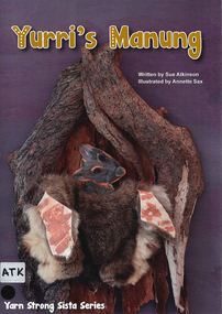
Book, Sue Atkinson, Yurri's manung, 2013
Yurri needed a warm place to sleep when winter came to the Barmah forest, her friends had no room for her in their homes in the trees, bushes, burrows and caves of the forest. With the help of Uncle Ambrose a Yorta Yorta Elder they make her a home of her own. Yurri?s Manung written by Sue Atkinson (Yorta Yorta) and illustrated by Annette Sax (Taungurung). This is the second book in the YSS series, giving insight into Indigenous Victorian culture. The ?Yarn Strong Sista? series is supported by background notes and ideas for related activities.Illustrations, maps, CDyorta yorta, barmah forest, bark hut, language list, educational activities -
 Victorian Aboriginal Corporation for Languages
Book, Hetti Perkins, Crossing country : the alchemy of Western Arnhem Land art, 2004
Hetti Perkins introduces this collection of reproductions of of Western Arnhem Land bark paintings, rock art, woven fibre art and wooden sculpture that was exhibited by the Art Gallery of NSW in 2004, emphasising the cultural foundations of the Kuninjku artists, their beliefs, artistic conventions and innovations. The book includes interviews with traditional rock and bark artists (including some language), and essays describing the connection of the people to the land, their spiritual beliefs and their art. There are also reproductions of works on paper and woven forms and an essay on the role of women in producing these art forms. An essay by Professor Jon Altmann is entitled "Brokering Kuninjku Art: Artists, Institutions and the Market. A chronolgy details the history of aboriginal art in the area, there are biographies of the artists whose works were included in the exhibition, a list of the works themselves, a glossary of place names, art terms, aboriginal, linguistic and anthropological terms, and a select bibliography. The list of contributors includes, as well as the two mentioned above, Dr Murray Garde, Apolline Kohen, Steven Miller, Cara Pinchbeck and Dr Luke Taylor.Colour photographs -
 Uniting Church Archives - Synod of Victoria
Photograph, undated c.1980s
Rosalie Rayment originally trained and worked as an Occupational Therapist. Following completion of studies in Theology she worked for 11 years with the Church in Thailand. Rosalie was ordained in 1988. Fred Vanclay B.D., Dip AgS. ordained 1964 in the Presbyterian Church. Served: Queensland 1961 - 1975; Victoria 1976 - 1985 Vermont - Parkmore; Northern Territory Tennant-Barkly Patrol 1985 - 1993. Died in 2016. Adapted from the eulogy given by his son, Jerry Vanclay One of Fred’s first placements as a minister was in Mackay, North Queensland. Mackay was a wonderful place for Fred, his wife Donna and their young family. They all loved the beaches and the bush, and the children completed a significant part of their schooling there. Whilst posted in Mackay, Fred and Donna enjoyed long road trips in their modest HR Holden sedan, with the family, to Uluru, to Broome via the Borroloola Track, and down the Birdsville Track to the Flinders ranges; along the way, developing the bushcraft that would stand them in good stead later in the Tennant-Barkly Patrol. After many years in ministry in Mackay, then in Vermont, Victoria, Fred and Donna were called to the Tennant-Barkly Patrol in the Northern Territory, where he served for eight years, probably Fred’s most satisfying years. All Fred’s parishes were welcoming and rewarding, but Fred said on more than one occasion that he had a special love for the Patrol. He felt that in an urban congregation, he ministered mainly to those who came to Church, but in the Patrol he ministered to everyone, and especially to those in need. Fred loved to get involved with the day-to-day activities of his people, to develop a deeper relationship and greater understanding. Some remarked that when Fred helped, everything took longer, but they loved him and his assistance nonetheless. Fred was proud to follow in the footsteps of his predecessor Padre Fred McKay, and sometimes joked that he was “Fred the 2nd”, not Fred McKay, but “Fred from Mackay”. During his last few weeks in hospital, Fred liked to reminisce on his time in the Patrol. He joked about how he surprised the selection panel with his knowledge of bush tracks and outstations – knowledge that he had gained on those long road trips from Mackay. He reflected that many aspects of his life were good preparation for his time in the Patrol. After their Patrol, Fred and Donna retired to Mt Waverley, in Melbourne, but they were both restless in retirement, and undertook supply ministries in Wedderburn, Kerang and North Cairns, and made several long journeys into the interior and into their beloved Patrol [in Tennant Creek] – as well as frequent visits to their eight grandchildren and two great-grandchildren, and occasional trips to Europe to reunite with distant family. They never tired of ministering and adventuring, but as age and infirmity progressively clipped their wings, they travelled more in spirit and less by car. Despite the many celebrations that he blessed – baptisms, marriages, and funerals – Fred never sought the limelight, and I think he would be surprised by our gathering today. I can almost hear him saying “Don’t make a fuss; just say a heartfelt prayer together”. – Jerry Vanclay Informal B & W gloss photo of Rev. Fred Vanclay, his wife Donna, Rosalie Rayment (later ordained) and one other unidentified person. -
 Forests Commission Retired Personnel Association (FCRPA)
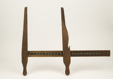
Wooden tree measuring calipers (inches)
Foresters usually measure the diameter of trees at Breast Height – traditionally 4 foot, 6 inches – now 1.3 m – which is termed Diameter Breast Height Over Bark (DBHOB). The most common way to measure tree diameter is to place a calibrated tape around the stem at breast height. It’s simple, but can be slow, particularly if the scrub is thick, or if there are heaps of trees. A tree caliper is another quick method of estimating DBHOB. Wooden tree measuring calipersMeasurements are in inches (pre metrication in 1974) A crown faint crown mark (331) and crows foot is visible on one end forest measurement -
 Ballarat Heritage Services
Photograph - Image, "A Native Burial Place (Weeping Caps in Foreground), c1918, c1918
... A burial place, surrounded with bark. ... with bark. "A Native Burial Place (Weeping Caps in Foreground ...A burial place, surrounded with bark. central australia, aborigines, aboriginal burial place, burial caps, aboriginal -
 Ballarat Tramway Museum
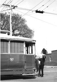
Photograph - Black & White Photograph/s, Charles Craig, 1971
Has a strong association with the crewman and demonstrates the work in placing a trolley pole on the overhead.Black and white photographs of the conductor (or motorman) placing the trolley pole of a single trucker on the overhead, shielding his eyes, at the Mt Pleasant terminus, corner of Cobden and Barkly Streets. A lady in a hat is speaking to him. Photo shows the trolley pole positioning device in the overhead. Possibly No. 30, see Reg item 6803. Photo by Charles Craig, probably August 1971.trams, tramways, trolley poles, mt pleasant, conductors, tram 30 -
 Ballarat Tramway Museum
Photograph - Digital image Set of 10, Tony Smith, 5/09/1971 12:00:00 AM
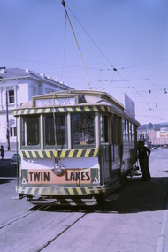
Yields information about Ballarat Tramways and trams prior to the closure of the tramway system.Set of 10 digital images of Ballarat trams prior to closure, scanned from original slides by Tony Smith, 1971 prior to closure of the system. This set of slides, possibly on the last weekend of Mt Pleasant services - closure took place on 5/9/1971. . .1 - 17 at the City terminus, north side. Tram showing the destination of Sebastopol and has a Twin Lakes sign. .2 - 26 at the city terminus, south side with Geommola's Pharmacy and Kodak Film advert and Town Hall in the background. .3 - 43 at the City terminus, north side, with destination of Mt Pleasant. Has a number of men at the tram stop. .4 - 14 leaving Bridge St, crossing Grenville St into Sturt St, with destination of City. Has the Dickins and Woolworths Big W store in the background. .5 - 43 at Mt Pleasant terminus with conductor boarding the tram. Tram has destination of Gardens via Sturt St West. In the background is the corner store with adverts for The Sun, Womens Weekly, Coca Cola and Robur Tea. .6 - 43 and 26 Barkly St, about to arrive at the Grant St loop. Both trams inbound. .7 - 43, 26 and 27 at Grant St loop. .8 - 12 (Lydiard St Nth) and another bogie tram at the city terminus north with the Town Hall in the background. .9 - 39 outbound in Barkly St to Mt Pleasant - note the new bus stop signs on either side of the tram. 10 - 27 (City) and 26 turning from Barkly St into Main St with the Ampol petrol station, a general store advertising Escort cigarettes and The Age in the background . On the right hand side is a fish and chips shop advertising crays and drinks.trams, tramways, sturt st, city, grenville st, bridge st, mt pleasant, barkly st, grant st, main st, closure, tram 17, tram 26, tram 43, tram 14, tram 12, tram 27, tram 39 -
 Ballarat Tramway Museum
Photograph - Digital image Set of 10, Tony Smith, 5/09/1971 12:00:00 AM
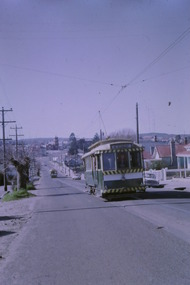
Yields information about Ballarat Tramways and trams prior to the closure of the tramway system.Set of 10 digital images of Ballarat trams prior to closure, scanned from original slides by Tony Smith, 1971 prior to closure of the system. This set of slides, possibly on the last weekend of Mt Pleasant services - closure took place on 5/9/1971. .1 - 13 outbound in Barkly St, Mt Pleasant - with another single trucker and the Ballarat Fire Station in the background. .2 - Bogie tram and single trucker at Grant St Loop. Has the Mobile service station on the right hand side. Note the family sitting on the steps of a house on the left side watching proceedings. .3 - 14 (Mt Pleasant) and 39 ditto. .4 - 27? and 39 crossing at the Morrison St loop. .5 - 14 and another single trucker at Mt Pleasant terminus. Has the corner store in the background with adverts for Robur Tea, Womens Weekly and Coca Cola. .6 - 39 and two single truckers at the Mt Pleasant terminus. .7 - View looking south along Ripon St from Mair St, with power station buildings on the right hand side. Shows the power distribution poles on the street. .8 - Scrubber tram on 0 road with tennis court alongside. .9 - 40 running special in Wendouree Parade, near the Haddon St intersection. .10 - 40 turning from Macarthur St into Drummond St Nth.trams, tramways, mt pleasant, barkly st, grant st, victoria park, sturt st west, ripon st, view st, depot, wendouree parade, drummond st nth, macarthur st, closure, tram 14, tram 39, tram 13, tram 26, tram scrubber, 40 -
 Bendigo Historical Society Inc.
Document - Forests Commission of Victoria Northern Area Fire Protection Policy, Statement, Future Bush Fire Policy, Plan for Fire Control, 1938-1939
Fanned by powerful winds, the Black Friday fires (13 January 1939) swept rapidly across large areas of Victoria, causing widespread destruction. Flames leaped large distances, and giant trees were blown out of the ground by fierce winds. Large pieces of burning bark (embers) were carried for kilometres, starting new fires in places that had not previously been affected by flames. Almost two million hectares burned across the state. Large areas of state forest, containing giant stands of Mountain Ash and other valuable timbers, were destroyed. As a result, approximately 575,000 hectares of reserved forest and 780,000 hectares of Crown land burned.Four Files Forests Commission of Victoria Northern Area Report on the 1938-39 Fire Season; and the Fire Protection Policy in Respect of Field activities Prior to the Incidence of the 1939 Fires. history, bendigo, forests commision of victoria, 1939 bush fires -
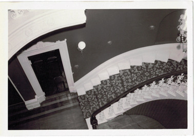 Kew Historical Society Inc
Photograph - 'Butleigh Wooton', 867 Glenferrie Road, John T Collins, 1979
in 1882 Thomas Maidment paid the Society of Jesus £5,750 for nine allotments along Barkly Road (now Glenferrie Road). Maidment, who had arrived in Australia from the Glastonbury district in England in 1858, owned and managed a number of sheep stations in Victoria and subsequently became an '... eminently respectable ...' member of District society. In 1883 the Rate Books list Maidment's land in Barkly Road as the 'Buxton Hill Estate' and it was given an N.A.V. of £90, while in the following year his property attracted an N.A.V. of £160, suggesting that substantial improvements were taking place. Maidment's two-storey mansion, named 'Butleigh Wooton' after his birth-place in England, was completed in 1885 and was given an initial N.A.V. of £420. While Maidrnent is recorded as the owner of the building until at least 1896, Jane Maidment, his wife, continued the family ownership of the twenty-six roomed house with its extensive grounds until at least 1910. (Sanderson P. City of Kew Urban Conservation Study Vol 2)Butleigh Wooton is a substantial two storeyed house built in the Italianate style common in the 1880s. Its walls are rendered and it has limited applied decoration that includes brackets to the eaves line and engaged ionic columns under a broken pediment over the front entrance. The bowed window unit is of particular distinction and is not at all typical of this type of building. This interior by John T Collins is a view of the staircase from the first floor landing. (Sanderson P. City of Kew Urban Conservation Study Vol 2)Reverse: "JOHN COLLINS / 11 Anderson Road / Hawthorn East, 3123 / Film 395 Exposure 27A / Kew / Butleigh Wooton / Looking down on stairs / 8-4-79thomas maidment, butleigh wooton, 867 glenferrie road -- kew (vic.)