Showing 3431 items
matching distances
-
 Stawell Historical Society Inc
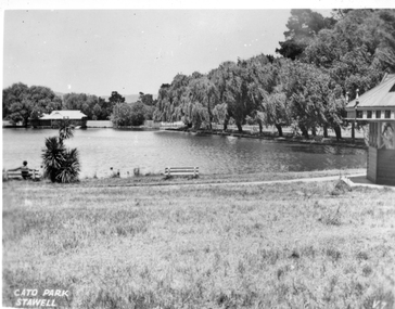
Photograph, Cato Lake looking towards the Stawell Swimming Clubrooms. c1930 - 1940
Looking across Cato Lake to Stawell Swimming Club Changing Rooms. Black Range in the distance and Gazebo on the right. There are 2 bench seats beside the lake and a person sitting in one on the right hand side. "Cato Park Stawell" is printed on the right lower corner. c 1930-1940Black & white photo of Cato Lake with change rooms in the distance. The view shows one side of the lake with trees along the edge and Gazebo on the right. Cato Park Stawellstawell -
 Victorian Harness Racing Heritage Collection at Lord's Raceway Bendigo
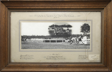
Photograph - Wooden framed photo finish, Akers & Co, Cooraminta, 26 August 1937
Cooraminta won the Distance Handicap Trot Bendigo on the 26 August 1937, followed by Phar Patrol and The Gap. Cooraminta owned by Mr J Lewis, was trained and driven by C Robertson Jun. Two colour photographs, one small one large in a brown frame. At the top: Distance Handicap Trot Bendigo / 26-8-37 At the bottom: Left corner: Owner Mr J Lewis / Trained and Driven by C Robertson Jun Centre: Won by Cooraminta / Phar Patrol 2nd / The Gap 3rd Right corner: Distance 1 1/4m / H'Cap 12 y bnd / Time 3m 0 3/4s / Akers & Co, 486 Bourke St Melbournehorses, race, winner, bendigo trotting club, driver, trainer, owner, bendigo, 1937, cooraminta, mr j lewis, phar patrol, the gap, charlie robertson jnr, c robertson jnr, charlie robertson, c robertson -
 Lakes Entrance Historical Society
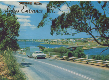
Postcard - Views of Lakes Entrance c1972, 1972 c
Princes Highway looking down to North Arm bridge with town in distance, people camped on North Arm foreshore and car towing caravan in foreground Lakes Entrance VictoriaColour postcard taken from Princes Highway looking down to North Arm bridge with town in distance, people camped on North Arm foreshore and car towing caravan in foreground Lakes Entrance VictoriaGreetings from Lakes Entrancebridges, roads and streets, township, vehicles -
 Stawell Historical Society Inc
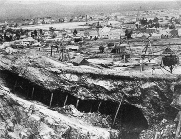
Photograph, Panorama of Mining Scene from Big Hill with the Open cut in foreground
Mining Scene from Big Hill. Open cut in fore ground with support timbers. Whims and poppet heads. Shows back of New Court House in Patrick Street. The flat area in distance is St Georges Crushing Battery settling Dam.Open Cut with supporting timbers in foreground, Various poppet Heads at centre of image. Wimmera Crushing Mill settling dam in distance. Rear of new Court House visiblestawell mining -
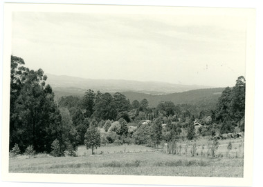 Mt Dandenong & District Historical Society Inc.
Photograph
In 1913 Edgar Dower took a photograph from this spot on Ridge Road that became known as Point Clear showing the Mt Dandenong township behind a stand of tall, dead trees. John Lundy-Clarke took this photograph from a similar spot at the Mt Dandenong Arboretum in 1975.Black and white photograph showing a cleared area in the foreground with young tress in the centre and hills in the distance. Several rooftops can be seen mid photo on the right. Reverse of photograph has handwritten description by John Lundy-Clarke.1975 View from the Arboretum over Mt D'nong township at the spot where Edgar Dower took the 1913 photo. The Falls gully is in the middle distance. Peter Damman's fence running downhill right foreground.edgar dower, point clear, mt dandenong, john lundy-clarke, peter damman, arboretum -
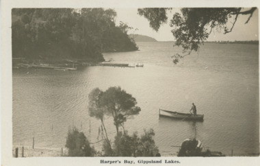 Lakes Entrance Historical Society
Postcard - Harpers Bay Gippsland Lakes, H D Bulmer, 1925 c
Harpers Bay showing the jetty where tourist launches moored for passengers to land and walk up to Mrs Westersons Cliffcrest Tea Rooms, Jemmys Point in distance Gippsland Lakes VictoriaBlack and white postcard of Harpers Bay showing the jetty where tourist launches moored for passengers to land and walk up to Mrs Westersons Cliffcrest Tea Rooms, Jemmys Point in distance Gippsland Lakes VictoriaHarpers Bay Gippsland Lakesbridges, islands, waterways, gippsland lakes -
 Sunbury Family History and Heritage Society Inc.
Photograph, Rosa McCall, Old Broadmeadows Township, 1949
The former Old Broadmeadows township in the photograph was taken in 1949. The hotel is the two storey building in the middle distance and the former general store is partly hidden by trees on the RHS. The image is looking to the north in Fawkner Street, across the Moonee Ponds Creek. The township is now part of Westmeadows.Old Broadmeadows Township was an important stopping-off point for travellers on their way to Sydney on the Old Sydney Road, (now Mickleham Road) up until 1869 when Sydney Road was finally opened. A print of a non-digital black and white photograph of a small country township with a shop on the RHS and a two storey building in the middle distance. Pine trees are growing on either side of the roadway.old broadmeadows township, townships, moonee ponds creek, westmeadows -
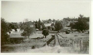
 Stawell Historical Society Inc
Photograph, Upper Main Street Reefs looking East towards Big Hill from the front of Joyce's Hibernian Hotel 1866
Upper Main Street Reefs looking East towards Big Hill taken from front of Joyce's Hibernian Hotel . Part of a collection of Photographs by Mr. O.G. Armstrong as commissioned by the Shire of Stawell for the Inter-colonial and Paris Exhibition in Melbourne in 1866. This scene was taken in 1866 in Main Street from in front of Joyce’s Iberian Hotel on the left, the site of the present townhall. It is looking uphill and eastward with Big Hill in the far background. The Hibernian Hotel was built on Commercial Street Pleasant Creek Goldfields in 1858 and was moved to Main Street Reefs, the present site of the Town Hall by Mr. & Mrs. Joyce. It was later destroyed by fire and the Town Hall built on its location. Street scene with buildings in distance and Big Hill in far distance.stawell streetscape -
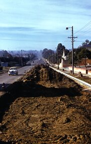 Surrey Hills Historical Society Collection
Photograph - Digital photograph, George L Coop, Whitehorse Road Mont Albert during road widening, 1958, c1958
The donor George Lister Coop was about 21 years of age when he took this photo in 1958 as Whitehorse Road was being widened. This was done in sections. It was taken from adjacent to the Coop family home at No.688. The house on the corner of High Street and Whitehorse Road (39 High Street) can be seen in the middle distance. A digital copy of a colour photograph of Whitehorse Road, Mont Albert looking towards Box Hill. The chimneys of Box Hill Gasworks can be seen in the distance. It was taken from adjacent to No 688.george l coop, whitehorse road, box hill gas works, mont albert, 39 high street, road works -
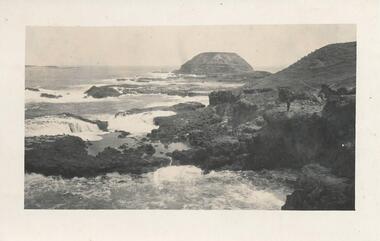 Phillip Island and District Historical Society Inc.
Photograph, 1930's
One of 23 photographs from the Jessie Smith Collection. Donated by Stan McFee.Black & White photograph The Nobbies with sea crashing on to the rocks. A figure of a man standing on rocks to the right of the photograph.On Back: "Nobbies - Seal Rocks in distance.the nobbies, phillip island, seal rocks, jessie smith collection, stan mcfee -
 Robin Boyd Foundation
Map, Australia
Map with sealed roads around parts of AustraliaHandwriting with distances to Melbourne, Yass, Albury.walsh st library -
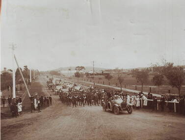 Sunbury Family History and Heritage Society Inc.
Photograph, A parade
The parade took place in Sunbury in 1919 and was held to welcome home the local returned soldiers, who had enlisted in World War 1. In the photograph the parade is approaching the intersection at Evans and Macedon Streets. Sunbury's Shopping complex now occupies the vacant land in the background, although for many years that land was the main sports ground. The building in the distance was the Sunbury Fire Brigade.Many Sunbury men enlisted to fight in World War 1. Sadly some did not return home but others did.A copy of a non-digital sepia photograph of a parade being led along a road by a vintage car. There is open land with a few buildings in the distance. Spectators are watching the parade on either side of the roadway.evans street, macedon street, world war 1., parades, welcome home receptions -
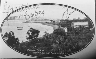 Phillip Island and District Historical Society Inc.
Photograph, Newhaven Jetty
Part of collection of Rose & Valentine Postcards copied by John Jansson 1984Black & White Postcard. View of Newhaven Jetty with San Remo in background. over printed "Greetings from Cowes" - CopyPhillip Island. Newhaven, San Remo in distance.local history, photography, photographs, views newhaven, phillip island, jetties, newhaven, san remo -
 Whitehorse Historical Society Inc.
Article, Attack on 'emotional blackmail', 1994
Emotive claims that Box Hill faced a takeover by Nunawading if the City of Whitehorse did not go ahead have outraged Nunawading Mayor, Kevin Abbott.Emotive claims that Box Hill faced a takeover by Nunawading if the City of Whitehorse did not go ahead have outraged Nunawading Mayor, Kevin Abbott. Cr Abbott said Box Hill was publicly distancing itself from Nunawading yet privately it has considered extending its boundary to divide Nunawading at Blackburn Road.Emotive claims that Box Hill faced a takeover by Nunawading if the City of Whitehorse did not go ahead have outraged Nunawading Mayor, Kevin Abbott. local government, city of nunawading, city of box hill, abbott, kevin, amalgamations -
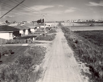 City of Kingston
Photograph - Black and white, c. 1960
This image depicts a scene of East Bentleigh in 1960, viewed along Thomasina Street as it crosses Gladwyn Street towards East Boundary Road in the distance. The gardens and new homes are well-tended, but the street surfacing is unsealed.Developing urban area now located within the City of Glen Eira, formally City of Moorabbin. This image illustrates the mid century urban sprawl of new suburbs and the subdivision of market gardens within the municipality and the changing demographic of the district as new houses are constructed and infrastructure established. Black and white photograph of unsealed road in new development in the area of Moorabbin, new houses appear on the lefthand side with paddocks on right side of image with installation of electric poles. Sealed road in the distance. Thomasina Street, as it crosses Gladwyn Street, East Bentleigh towards East Boundary Road. Handwritten in blue ink: 60 - 373 D Handwritten in red ink: 80% Handwritten in black ink: Ch. 6bentleigh, east bentleigh, market garden, housing, suburbs, infrastructure, moorabbin -
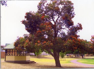 Stawell Historical Society Inc
Photograph, Cato Park Flame Tree playground c 1995 -- 2 Photos -- Coloured
2 Colour Photos Gateway, Flame Tree and Playground in Cato lake c 1985. This area was once the gateway to Cato lake but later moved. Both photos are near the lake as can be seen in 67.18a which has a view of the playground in the distance.Two colour photographs, one of the Gateway flame tree. the other a view of the edge of the lake with the playground in the distance. The flame tree in 67.18 shows the flame tree in flower beside the rotunda. The other photo 67.8a is a view of the edge of Cato lake with the playground in the background behind a group of trees. stawell -
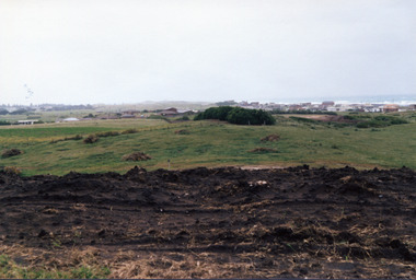 Port Fairy Historical Society Museum and Archives
Photograph
South Beach Developement Coloured photograph of Earthworks in foreground with a tree shelter belt in middle distance and South Beach Estate in distancesouth beach, development, road making, street -
Stawell Historical Society Inc
Painting, Nancy Rutter, "The Old Gum Tree" Painting by Nancy Rutter
Nancy Rutter Local ArtistArtists Card Australian landscape with Hills in Distance Two mid distance broke dead branch in left foregroundNancy Rutter The old Gum Tree Oil. on Rear of Painting along with information on Card Maker,australian landscape -
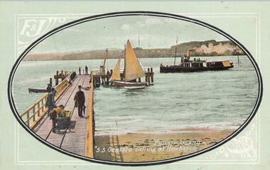 Phillip Island and District Historical Society Inc.
Photograph - Post Card, Early 20th Century
A Collection of postcards showing different views around Phillip Island. 10 of a collection of 11 postcards donated by M. Trott. Photo 1. S.S. Genista coming into Newhaven pier with another boat and people at the pier. Photo 2. The Granite Quarry at Cape Woolamai. Photo 3. View of the Newhaven pier with San Remo in the distance Photo 4. Milking Time, Newhaven. Photo 5. Wool Team on road to Cowes. Photo 6. View of the Cowes Jetty and Cowes in the background taken from a Steamer. Photo 7. View of Back Beach near The Nobbies. Photo 8. Cowes Jetty and Jetty Shed with Govt Steamer "Lady Loch" in the distance. Photo 9. Cape Woolamai coastline. Photo 10. Fisherman's Hut, Cowes with Jetty and boats in the background. 1. "S. S. Genista" calling at Newhaven. Phillip Island. 2. Phillip Island Granite Quarry, Cape Woollami 3. Phillip Island. Newhaven, San Remo in distance. 4. Phillip Island - Milking Time, Newhaven. 5. Phillip Island - Wool Team on road to Cowes. 6. Phillip Island - Cowes from Steamer. 7. Phillip Island - Back Beach. 8. Phillip Island - Cowes Jetty. Govt Steamer "Lady Loch" in distance. 9. Phillip Island - Cape Woollami. Home of Mutton Bird. 10. Phillip Island - Fisherman's Hut, Cowes.cowes jetty, newhaven jetty, granite quarry cape woolamai, phillip island coastline, fisherman's hut cowes, ss genista, lady loch steamer, m trott -
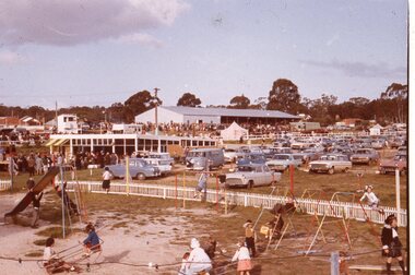 Stawell Historical Society Inc
Slide, Ian McCann, Stawell Show
Children playing on playground eqipment in foreground with car park in mid distance, crowd in far disatance and to the left mid distance.stawell show -
 Melbourne Tram Museum
Document - Notebook, Melbourne & Metropolitan Tramways Board (MMTB), "Tram / Bus Kilometres", c1965
... Distances ...Set of two notebook or lined journals, with light brown pig skin binding strips and in each of the corners binding, faint ruled Collins 4393 books with red labels on the outside binding, sewn sections, printed glued inside covers. Each book has been ruled in red ink, headed year and month, days, page totals with data entered for each depot of the distance or mileage or kilometres for each date, including separate tram and bus entries. .1 - Blue cloth covered with Letraset, black plastic strip on outside "Tram / Bus Kilometres" for the period 1-7-1965 to 30-6-1975. Notes change over to Kms from miles on 1/7/1974. Has head office contact details on the first page. .2 - Red cloth cover with Letraset black plastic strip on outside "Kilometres" drawn up for the period - 1-7-1975 to 13-11-1985, though drawn up to Jan. 1985. Has head office contact details on the first page. Has a note on the last used page about the instruction to discontinue the book on 13/11/1985 from Mr. W. Burrows.trams, tramways, tramcars, mileages, kilometres, buses, depots, distances -
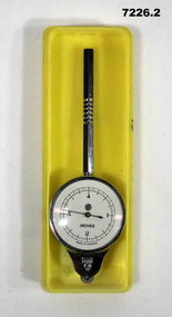 Bendigo Military Museum
Equipment - MAP MEASURER/OPISMETER, DEPOSE
Vintage opisometer used for measuring distances on maps. Part of the Kevin John Herdman, No. 397661, Collection. See Catalogue No. 5942P for details of his service record..1) Circular chromed metal instrument with handle. Calibrated dial with black markings and hand on a white background. Reverse face has unit conversion details in black text on white background. Each face is covered with a convex glass lens. On the opposite end to the handle is a small wheel with milled edge. As it turns, the hand on the front dial turns to measure distance. .2) Rigid plastic rectangular storage case in two parts. Base is yellow, top is clear..1) Printed on front dial: 'INCHES, MADE IN FRANCE'. Printed on back dial: 'Unit conversion details'. Stamped on metal near wheel: 'DEPOSE, H(logo)B'. .2) Stamped on clear cover: 'CURVIMETRE, MAP MEASURER, H(logo)B, MADE IN FRANCE'.map, map measure, equipment, opisometer, kevin john herdman -
 Clunes Museum
Photograph
VIEW OF SUSPENSION BRIDGE WITH TOWNSHIP IN THE DISTANCEsuspension bridge, local history -
 Port Fairy Historical Society Museum and Archives
Photograph
Last Train Leaving Port Fairy 10.09.1977Coloured Photograph of train moving into the distance transport, rail, road, train, last train -
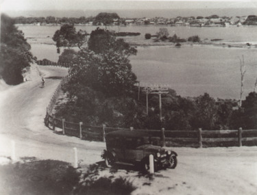 Lakes Entrance Historical Society
Photograph - Princes Highway around Jemmys Point, Lakes Entrance, H D Bulmer, 1930 c
Princes Highway around Jemmys Point, car parked on road at junction of original steep road to top of Jemmys Point. Man on bicycle riding up hill. Bullock Island and New Works in distance over North Arm and Cunninghame Arm waterways Lakes Entrance VictoriaBlack and white photograph of lower section of Princes Highway around Jemmys Point, car parked on road at junction of original steep road to top of Jemmys Point. Man on bicycle riding up hill. Bullock Island and New Works in distance over North Arm and Cunninghame Arm waterways Lakes Entrance Victoriaroads and streets, township, waterways, fences, vehicles -
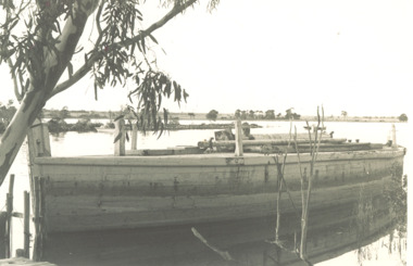 Lakes Entrance Historical Society
Photograph, Lady Harriet Barge, Lakes EntranceVictoria, 1988
Photograph taken after barge was purchased from Elliott family before being towed to Lakes Entrance for Entrance Centenary celebrations. , small jetty bottom left hand corner, Silt jetties with Jones Bay in distance limb of gum tree could be on the Mitchell River near Bairnsdale Gippsland Lakes VictoriaBlack and white photograph of Lady Harriets barge moored with mast removed and lying on deck, small jetty bottom left hand corner, Silt jetties with Jones Bay in distance limb of gum tree overhanging top left corner could be on the Mitchell River near Bairnsdale Gippsland Lakes Victoriabusinesses, barges, boats and boating -
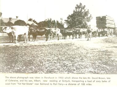 Port Fairy Historical Society Museum and Archives
Newspaper - Newspaper article
This photo was taken in Penshurst in 1903 which shows the late David Brown, late of Colerain Balmoral and his son, Albert, now residing at Gritjurk, transporting a load of sixty bales of wool from “Yat Nat Estate” near Balmoral to Port Fairy —a distance of 108 miles.Black and white photograph from a newspaper article with a large wool laden wagon with 14 bullocks yoked up The above photo was taken in Penshurst in 1903 which shows the late David Brown, late of Colerain Balmoral and his son, Albert, now residing at Gritjurk, transporting a load of sixty bales of wool from “Yat Nat Estate” near Balmoral to Port Fairy —a distance of 108 miles.transport, rail, road, bullocks, wagon, carrier, penshurst, balmoral, albert brown, david brown, wool bales, yat nat estate, gritjurk -
 University of Melbourne, Burnley Campus Archives
Photograph - Sepia print, A.E. Bennett, Entrance Gates, 1894-1990
Note by E.B. Littlejohn, "Is the roadway the original Swan Street? Entrance gates to Gardens in the distance. Roadway leading to the Pavilion hidden behind the trees. No elms showing along the roadway," and by T.H. Kneen, "The roadway appears to terminate at the gates outside the Curator's Residence, sweeping past the Pavilion on the right. I have seen a plan which showed an attractive avenue of trees (pine) from the western end of the property (where the Stockman's Cottage was later sited.)" 2 copies sepia photograph. Copy of sepia photograph of the roadway to the Entrance Gates and Curator's Cottage seen in the distance, with the Pavilion on the right, in, "Prize Essays," Alfred E. Bennett, c.1894, after p 116. Pinus radiata avenue on each side of the road.entrance gates, prize essays, alfred e. bennett, curator's residence, pavilion, stockman's cottage, pine tree avenue -
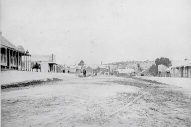
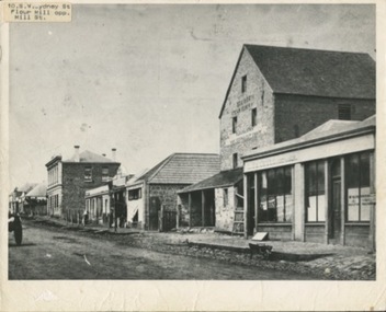 Kilmore Historical Society
Photograph, SW Sydeny Street, 1860
25cm x 20 cm black and white photograph mounted on board. The photograph is taken at an angle so you can see multiple buildings on the western side of Sydney Street including: Trainor's Steam Flour Mill, Parnells Boot Shop, Quinn Solicitor, Youngs Bakery and Post Office and Royal Oak Hotel in the distance.Written on the back: #10 Trainor's Steam Flour Mill, Parnell's Bootshop, Quinn Solicitor, Young's Bakery + Post Office #3.#5.10/86-38A Copy of Sydney St. Kilmore 1860 Trainors Mill (opposite present Mill St) Royal Oak Hotel in distance.post office, flour mill, bakery, bootmaker -
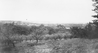 Ringwood and District Historical Society
Photograph, Overlooking Heathmont from Pump's orchard - 1926
Black and white photograph of orchard. Housing in distance.Typed below photograph, "Overlooking Heathmont from Pump's orchard, 1926".