Showing 10994 items matching " land"
-
 Federation University Historical Collection
Map - Documents, Documents relating to Land - Selection of Maps of subdivisions; Titles; Cemetery sections
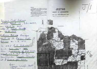
Maps indicate the land owned in various areas of Victoria - Mornington Peninsula, Ascot / Creswick areaLand maps showing block divisions and owners. Edward Carter Holmes J.P. selected land and called it Launchley - later called Wambalano.jeetho, county of mornington, edward carter holmes, joseph clarke, catherine holmes, talbot, william coghill, pre-emptive right, tourello pre-emptive right, glendonald pre-emptive right, clunes, smeaton, ascot, counties of ripon and talbot, certificate of title, ballaarat general cemetery, new cemetery, poowong, helen coghill -
 Kiewa Valley Historical Society
Report - Alpine Study Area Volume 2 Maps, Land Conservation Council, 1970s
The Victorian Environmental Assessment Council and the former Environment Conservation Council (ECC) and Land Conservation Council (LCC) have completed 36 land use investigations over more than 35 years, including 27 regional reviews. They provide a framework for use of Public Land in Victoria. The Land Conservation Council was established by the Land Conservation Act 1970.These maps provide an assessment of the Alpine area at the time the maps were created. Some of the topics eg. Rainfall and water resources may change over the years thus providing a comparative analysis. Others may provide information for future development such as mineral exploration, building of a dam / tunnel etc.Blue box shaped folder containing 9 of 10 Maps of the Alpine Study Area produced by the Land Conservation Council. Maps include 1. Public land and descriptive blocks. 2. Physiography. 3. Topography. 4. Geology (missing). 5. Rainfall and water resources. 6. Vegetation 7. Land systems. 8. Recreation. 9. Primary production. 10. Minerals Ex library item. Stamped in red "Discarded From Stock / Swan Hill Regional Libraryalpine area, maps of alpine area, land conservation council -
 Whitehorse Historical Society Inc.
Article, Land Which Overlooks Dandenongs, 1935
Sale of Land which overlooks Dandenongs.Land which overlooks Dandenongs : Real Estate is reviving between Box Hill and Croydon. Article on Box Hill to Croydon land development 1935.Sale of Land which overlooks Dandenongs.eastern suburbs, melbourne, real estate, transport, local government -
 Greensborough Historical Society
Aerial Photograph, Flintoff land - View from above, 1945_
Section of the 1945 Greensborough aerial survey, focusing on the land belonging to the Flintoff familyPhotocopy of section of 1945 aerial survey of Greensborough area"Flintoff land to west of Diamond Creek Rd" written in pencil on backflintoff family, aerial photograph -
 Otway Districts Historical Society
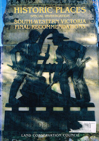
Book, Land Conservation Council, Historic places: special investigation: South-Western Victoria: Final recommendations, January 1997
The Land Conservation Council has carried out an investigation of historic places in public land in South-western Victoria. The report contains the Council's recommendations for the protection, management and future use of more than 700 historic places, out of 2200 places identified during the investigation. The places have been assigned to three categories, A, B and C, representing State, regional and local levels of significance. The report also contains recommendations relating to general historic places management, the processes available in Victoria for the protection of historic places on public land, and Aboriginal historic places.Historic places: Special investigation: South-Western Victoria: Final recommendations. Land Conservation Council. Land Conservation Council; Melbourne (Vic); January 1997. viii, 176 p.; illus.; maps. Soft cover. ISBN 0 7241 9290 5Maps in plastic sleeve.land conservation council; conservation; historic places; public land; aborigines; south west victoria; -
Whitehorse Historical Society Inc.
Letter - Correspondence, Obtaining a grant of Crown Land at rear of Myrtle Grove, 1932
Correspondence between Council and Closer Settlement Board re land in Pakenham Street including plans of allotments.Correspondence between Council and Closer Settlement Board re land in Pakenham Street including plans of allotments. Also further correspondence re land being sold by Malcolm Sheehan to Dal Hear.Correspondence between Council and Closer Settlement Board re land in Pakenham Street including plans of allotments.pakenham street, blackburn, myrtle grove, blackburn, shire of blackburn and mitcham, sheehan, malcolm, hearn, dal, victoria. closer settlement board -
 Otway Districts Historical Society
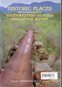
Book, Land Conservation Council, Historic places: Special investigation: South-Western Victoria: Descriptive report, January 1996
The south-west of Victoria, possessing a rich heritage of the signs of past human activity, is fertile ground for an investigation of historic places on public land. This report includes an initial inventory of almost 2000 places. The report outlines the history and the related heritage of the area, describes in some detail its biophysical attributes and introduces the natural resources and present land use. This information provides a context for understanding the origins of the historical features that are observes today.Historic places: Special investigation: South-Western Victoria: Descriptive report. Land Conservation Council. Land Conservation Council; Melbourne (Vic); January 1966. viii, 180 p.; illus.; maps. Soft cover. ISBN 0 7241 9288 3Maps in plastic sleeve.land conservation council; conservation; south-western victoria; historic places; -
 Greensborough Historical Society
Document - Certificate of Title, Alison land, 1840o
Land originally granted to John Alison 09/09/1840. Shows chain of ownership from Alison to Lecky, Mayger (Magyar) and Blay; Lecky to Charles Buck; Mayger to Whatmough.Shows part of the chain of ownership of this parcel of land in Greensborough.4 pages. Copies of land titles and associated documentsSome annotations by Noel Withersland titles - greensborough, mayger family, whatmough family -
 Bendigo Military Museum
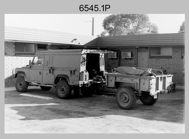
Photograph - 4th Field Survey Squadron - Land Rover Perentie Light Vehicles in the Field, 1987
This is a set of nine photographs featuring 4th Field Survey Squadron’s newly introduced Survey variant of the Land Rover Perentie light truck vehicle on a field trip in SA, in 1987. The Land Rover Perentie is a nickname for the Land Rover 110 produced by JRA Limited for the Australian Army, and part manufactured and assembled in Moorebank, New South Wales, during the 1980s and 1990s The name Perentie originates from Land Rover's successful tender to Project Perentie, which was the official Australian Army trial to select new 1 and 2-tonne light vehicles to replace the ageing fleet of Series 2A and 3 Land Rovers. The major differences between the Land Rover Perentie and British Land Rovers were the relocation of the spare wheel to a position under the rear of the load area, a galvanised chassis and the Isuzu engine. The Land Rover Perenties were produced in 4x4 and 6x6 variants and powered by an Isuzu 3.9-litre four-cylinder 4BD1 diesel engine. The Truck, Panel, Lightweight, Survey, FFR, Winch, MC2 model was one of eight 4x4 variants built for the Australian Army. There were 35 Vehicles built to satisfy the operational requirements of RA Svy’s units. Source – Wikipedia. See item 6544.35P for related photos of these vehicles.This is a set of 35 photographs featuring 4th Field Survey Squadron’s newly introduced Survey variant of the Land Rover Perentie light truck vehicle, at Keswick Barracks, Adelaide SA in 1987. The black & white photograThis is a set of nine photographs featuring 4th Field Survey Squadron’s newly introduced Survey variant of the Land Rover Perentie light truck vehicle on a field trip in SA, in 1987. The black & white photographs are on 35mm negative film and are part of the Army Survey Regiment’s Collection. The photographs were scanned at 96 dpi. .1) - Photo, black & white, 1987. Perentie Land Rover with trailer parked outside unknown motel in SA. .2) & .3) - Photo, black & white, 1987. Field trip featuring Perentie Land Rover. .4) - Photo, black & white, 1987. Field trip featuring Perentie Land Rover. Series 3 Land Rover parked behind. Unidentified personnel. .5) & .6) - Photo, black & white, 1987. Field trip featuring Perentie Land Rover. Unidentified personnel. .7) & .8) - Photo, black & white, 1987. Field trip featuring Perentie Land Rover. Typical sandy 4WD track on fence line. .9) - Photo, black & white, 1987. Field trip featuring Perentie Land Rover. Probable gas extraction facility..1P to .9P – There are no personnel identified. ‘PERENTI MOTOR VEHICLES JUL 87’ annotated on negatives sleeve.tified. royal australian survey corps, rasvy, 4 fd svy sqn -
 City of Kingston
Pamphlet - Colour, W. H. Wood Estate Agent, Subdivisional Land Auction Barker's Estate Cheltenham, 1919
Sales plan for land in the suburb of Cheltenham, along Barker StreetThe developing urban area of Cheltenham within the City of Kingston. This land sale pamphlet illustrates the subdivision of land within the municipality and the changing demographic of the district as new houses are constructed.Colour pamphlet advertising subdivisional land auction of Barker's estate, on Barker Street Cheltenham.Handwritten in grey pencil on the subdivision map: a series of numbers on each block possibly indicating the sale price. Handwritten in grey pencil on the subdivision map: Roy- joined to subdivision 6 Handwritten in grey pencil on the subdivision map: x on the border between subdivision 17 and 16, and again on the border between subdivision 12 and 11.cheltenham, land sales, estate -
 Greensborough Historical Society
Document - Certificate of Title, Partington land, 30/09/1878
Certificates of title and associated documents relating to land owned by Charles Partington: Vol. 3200 Vol. 639882; 30/09/1878. Includes transfer of title to executors William James Partington and Maria Partington on the death of Charles Partington 16/05/1907.Shows part of the chain of ownership of this parcel of land in Greensborough. The Partingtons were Greensborough pioneers5 pages. Copies of land titles and associated documentsland titles - greensborough, partington family -
 Bendigo Military Museum
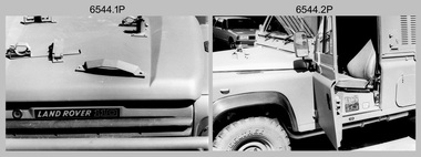
Photograph - 4th Field Survey Squadron - Land Rover Perentie Light Vehicles, Keswick Barracks, Adelaide SA, 1987
This is a set of 35 photographs featuring 4th Field Survey Squadron’s newly introduced Survey variant of the Land Rover Perentie light vehicle, at Keswick Barracks, Adelaide SA in 1987. The Land Rover Perentie is a nickname for the Land Rover 110 produced by JRA Limited for the Australian Army, and part manufactured and assembled in Moorebank, New South Wales, during the 1980s and 1990s The name Perentie originates from Land Rover's successful tender to Project Perentie, which was the official Australian Army trial to select new 1 and 2-tonne light vehicles to replace the ageing fleet of Series 2A and 3 Land Rovers. The major differences between the Land Rover Perentie and British Land Rovers were the relocation of the spare wheel to a position under the rear of the load area, a galvanised chassis and the Isuzu engine. The Land Rover Perenties were produced in 4x4 and 6x6 variants and powered by an Isuzu 3.9-litre four-cylinder 4BD1 diesel engine. The Truck, Panel, Lightweight, Survey, FFR, Winch, MC2 model was one of eight 4x4 variants built for the Australian Army. There were 35 vehicles built to satisfy the operational requirements of RA Svy’s units. Source – Wikipedia. See item 6545.9P for related photos of these vehicles.This is a set of 35 photographs featuring 4th Field Survey Squadron’s newly introduced Survey variant of the Land Rover Perentie light truck vehicle, at Keswick Barracks, Adelaide SA in 1987. The black & white photographs are on 35mm negative film and are part of the Army Survey Regiment’s Collection. The photographs were scanned at 96 dpi. .1) to .8) - Photo, black & white, 1987. Land Rover Perentie light truck vehicle features. .9) - Photo, colour, 1986. L to R: unidentified, RQMS - WO2 Peter Symmans, unidentified. .10) to .15) - Photo, black & white, 1987. Land Rover Perentie light truck vehicle features. .16) - Photo, black & white, 1987. Land Rover Perentie light truck vehicle. L to R: WO2 Russ Larsen, SSGT Barry Lutwyche, 2IC Terry Lord, SGT Mick Hogan, unidentified. .17) - Photo, black & white, 1987. Land Rover Perentie light truck vehicle features. .18) & .19) - Photo, black & white, 1987. Loading field trip stores into Land Rover Perentie light truck vehicle. .20) & .21) - Photo, black & white, 1987. L to R: SPR Steve Perks, SGT Mick Hogan loading field trip stores into Land Rover Perentie light truck vehicle. .22) to .25) - Photo, black & white, 1987. L to R: SPR Steve Perks loading field trip stores into Land Rover Perentie light truck vehicle. .26) - Photo, black & white, 1987. CAPT Danny Galbraith loading field trip stores into Land Rover Perentie light truck vehicle. .27) to .31) - Photo, black & white, 1987. Loading field trip stores into Land Rover Perentie light truck vehicle. .32) to .34) - Photo, black & white, 1987. Land Rover Perentie light truck vehicle – broken transfer case lever. .35) - Photo, black & white, 1987. Land Rover Perentie light truck vehicle’s Isuzu 3.9-litre four-cylinder 4BD1 diesel engine..1P to .35P – There are no personnel identified. ‘PERENTI MOTOR VEHICLES JUL 87’ annotated on negatives sleeve.royal australian survey corps, rasvy, 4 fd svy sqn -
 Melbourne Legacy
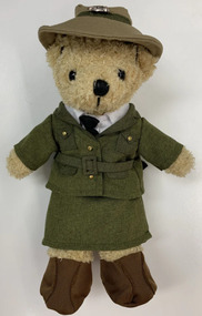
Leisure object - Toy Bear, Legacy Bear $20 - Female Land Army Bear, 2022
In the 2000s Legacy released a range of Legacy Bears to expand the merchandise available for sale during Legacy Week and at other fundraising opportunities during the year. This special edition WW2 land army bear was released in 2019. The Women's Land Army (WLA) was a British civilian group created during World War II to replace the men called up for the military. Over 80,000 women served working on farms, in sawmills, and in forestry. They became know as Land Girls and Lumber Jills. Please note the archive does not have a copy of this bear but is recorded here to complete the series.An example of the type of products sold along with Legacy Badges for fundraising in the 2010-2020s.Legacy bear dressed in a female WW2 Land Army uniform with a printed cardboard tag.Printed tag gives the price as $20.legacy appeal, fundraising, legacy bear -
 Greensborough Historical Society
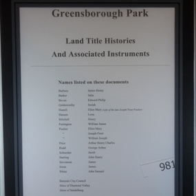
Folder of Documents, Greensborough Park: Land Title Histories and Associated Instruments, 1872-1976
Land title documents trace the ownership of what is now known as Greensborough Park from 1872 to 1976.This property was owned at various times by well known Greensborough identities. The documents show the change from private ownership to public ownership of the site.Folder of copies of land title documents. 20 pages. Includes CD of electronic copies.greensborough park, banyule city council, shire of heidelberg, shire of diamond valley -
 Greensborough Historical Society
Document - Certificate of Title, Mayger land, 1863o
Land originally granted to John Alison 09/09/1840. 1. Certificate of Title: Edwin Willis Mayger 14/08/1863: Vol. 5 Fol. 860. 2. Transfer document: 2 mortgages for Edwin Willis Mayger; Transfer from Mayger to Charles Partington. Shows part of the chain of ownership of this parcel of land in Greensborough.2 pages. Copies of land titles and associated documentsland titles - greensborough, mayger family, partington family, maygar family -
 Ballarat and District Irish Association
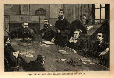
Image, Land League Committee Meeting, Dublin, 1864
The Irish National Land League (Irish: Conradh na Talún) was an Irish political organisation of the late 19th century which sought to help poor tenant farmers. Its primary aim was to abolish landlordism in Ireland and enable tenant farmers to own the land they worked on. The period of the Land League's agitation is known as the Land War. Within decades of the league's foundation, through the efforts of William O'Brien and George Wyndham (a descendant of Lord Edward FitzGerald), the 1902 Land Conference produced the Land (Purchase) Act 1903 which allowed Irish tenant farmers buy out their freeholds with UK government loans over 68 years through the Land Commission (an arrangement that has never been possible in Britain itself). For agricultural labourers, D.D. Sheehan and the Irish Land and Labour Association secured their demands from the Liberal government elected in 1905 to pass the Labourers (Ireland) Act 1906, and the Labourers (Ireland) Act 1911, which paid County Councils to build over 40,000 new rural cottages, each on an acre of land. By 1914, 75% of occupiers were buying out their landlords, mostly under the two Acts. In all, under the pre-UK Land Acts over 316,000 tenants purchased their holdings amounting to 15 million acres (61,000 km2) out of a total of 20 million acres (81,000 km2) in the country. Sometimes the holdings were described as "uneconomic", but the overall sense of social justice was undeniable. (http://en.wikipedia.org/wiki/Irish_National_Land_League, accessed 21 January 2014) The Irish National Land League was founded at the Imperial Hotel in Castlebar, the County town of Mayo, on 21 October 1879. At that meeting Charles Stewart Parnell was elected president of the league. Andrew Kettle, Michael Davitt, and Thomas Brennan were appointed as honorary secretaries. This united practically all the different strands of land agitation and tenant rights movements under a single organisation. The two aims of the Land League, as stated in the resolutions adopted in the meeting, were: ...first, to bring out a reduction of rack-rents; second, to facilitate the obtaining of the ownership of the soil by the occupiers. That the object of the League can be best attained by promoting organisation among the tenant-farmers; by defending those who may be threatened with eviction for refusing to pay unjust rents; by facilitating the working of the Bright clauses of the Irish Land Act during the winter; and by obtaining such reforms in the laws relating to land as will enable every tenant to become owner of his holding by paying a fair rent for a limited number of years. Charles Stewart Parnell, John Dillon, Michael Davitt, and others including Cal Lynn then went to America to raise funds for the League with spectacular results. Branches were also set up in Scotland, where the Crofters Party imitated the League and secured a reforming Act in 1886. The government had introduced the first ineffective Land Act in 1870, then the equally inadequate Acts of 1880 and 1881 followed. These established a Land Commission that started to reduce some rents. Parnell together with all of his party lieutenants, including Father Eugene Sheehy known as "the Land League priest", went into a bitter verbal offensive and were imprisoned in October 1881 under the Irish Coercion Act in Kilmainham Jail for "sabotaging the Land Act", from where the No-Rent Manifesto was issued, calling for a national tenant farmer rent strike which was partially followed. Although the League discouraged violence, agrarian crimes increased widely. Typically a rent strike would be followed by evictions by the police, or those tenants paying rent would be subject to a local boycott by League members. Where cases went to court, witnesses would change their stories, resulting in an unworkable legal system. This in turn led on to stronger criminal laws being passed that were described by the League as "Coercion Acts". The bitterness that developed helped Parnell later in his Home Rule campaign. Davitt's views were much more extreme, seeking to nationalise all land, as seen in his famous slogan: "The land of Ireland for the people of Ireland". Parnell aimed to harness the emotive element, but he and his party preferred for tenant farmers to become freeholders on the land they rented, instead of land being vested in "the people".(http://en.wikipedia.org/wiki/Irish_National_Land_League, accessed 21 January 2014)Image of a number of men sitting around a table. They are members of the Land League Committee during a meeting in Dublin.ballarat irish, land league, land league committee, dublin -
 Ringwood and District Historical Society
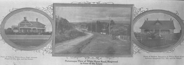
Photograph, Strip of images used for Ringwood Heights Estate land sale promotion - 1924
Strip of 3 views apparently part of a land sale advertisement - View of Whitehorse Rd between photos of two Whitehorse Rd houses.Typed on back of photographs, "Ringwood Heights Estate. Land on left of road and down to Mullum Creek. Sold by T. Grant. 97 lots, 1st March 1924. J.B. McAlpin, agent. No deposit, 1 pound per month." -
 Ringwood and District Historical Society
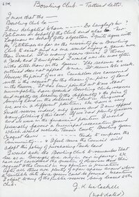
Letter, JK McCaskill objecting to the Bowling Club using further public reserve land
1929 saw the establishment of the Ringwood Bowls Club initially located on the land now occupied by the Eastland Shopping Centre. It moved to its current location in Loughnan Road, Ringwood in 1997.JK McCaskill objecting to the Bowling Club using further public reserve land. Undated.city of ringwood bowls club, ringwood bowling club, ringwood bowls club, lawn bowls, bowling -
 Greensborough Historical Society
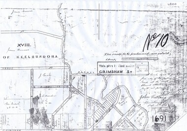
Plan, Parish Plan Map of Land North of Grimshaw Street, 11/12/1879
Part of Parish plan of land north of Grimshaw Street bounded by the Plenty River. Includes annotation signed by John Scotland and J. W. Britnell, dated Dec. 11th 1879.Photocopy of part of Parish plan of land north of Grimshaw Street bounded by the Plenty River. Includes annotation signed by John Scotland and J. W. Britnell, dated Dec. 11th 1879greensborough, grimshaw street greensborough, jonah britnell, john scotland -
Federation University Historical Collection
Document, License under Section 19 of "The Land Act 1869", 1875
Full license and authority to enter and occupy Crown Land outlined was given to James Cowan. This was for a period of three years and subjected to conditions outlined on the document. The area was in the County of Bourke, Parish of Blackwood. The area concerned is located on the Lerderderg River in the Wombat State Forest. The fee for occupation was to be paid in advance by half-yearly payments to the Land Officer at Ballarat. The document signed on 1 July 1875 by William F Stawell, Acting Governor of Victoria.Thick pale blue paper. Hand written in ink Hand drawn map of land in questionDated 1 July 1875 Signed William F Stawelllicence, license, crown land, james cowan, county of bourke, parish of blackwood, lerderberg river, wombat state forest, william foster stawell, acting governor, land officer, ballarat -
Ringwood and District Historical Society
Report, McAlpin, J.B, Report and valuation of land in Ringwood 1931, 23-Nov-31
Report and valuation of land in Ringwood in the name of David Bull EsqSingle page hand written report - valuation of land in Ringwood with area map. +Additional Keywords: McAlpin, J.B. / Bull, David -
 National Wool Museum
Newspaper, Stock and Land
"Stock and Land" newspaper, Wednesday 10th October, 1951, addressed to Mr HL Cameron, Box 26, Warnambool."Stock and Land" newspaper, Wednesday 10th October, 1951, addressed to Mr HL Cameron, Box 26, Warnambool.agriculture - news, stock and land, woods, mr george -
 Greensborough Historical Society
Folder, Peter Simmenauer, Partington land, edited by Peter Simmenauer, 1850-1950
Folder of documents relates to ownership of Crown Portion 13, Parish of Nillimbuk, County of Evelyn, purchased by John Alison in 1840 and sold to various people including Charles Partington Snr in 1878. It includes Certificates of Title recording transfers to Charles' children, and details of the land retained by Charles Jnr and Joseph Partington until their deaths in 1932 and 1943 respectively. A list of sales of allotments in the "Greenhills Estate" is also included.Folder of documents including Certificates of Title and other land documentsjohn alison, charles partington, charles partington junior, joseph partington, greenhills, partington family, greensborough, willis vale -
 Greensborough Historical Society
Document - Certificate of Title, Flintoff land, 1897o
1. Certificate of Title: Edith Flintoff 26/10/1897: Vol. 2659 Fol.531750. 2. Transfers of (1) Edith Flintoff, Edith Fullwood, John Bosch. 3. List of transfers from Frederick Nevins Flintoff including to Robert Whatmough and John McLaughlin. 4. Plenty River to Diamond Creek Road (plan) shows land belonging to Edith Flintoff, Edith Fullwood, John Bosch. 5. Register of proprietors including Edith Flintoff of Nillumbik, Portion 14, Vol. 2659 Fol.531750.Shows part of the chain of ownership of this parcel of land in Greensborough.5 pages. Copies of land titles and associated documentsflintoff family, land titles - greensborough -
 Kew Historical Society Inc
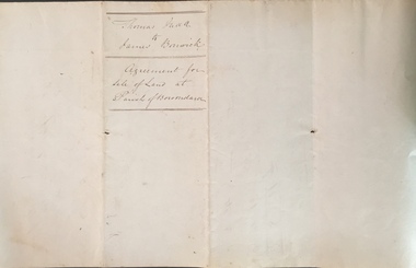
Legal record (Item), Thomas Judd to James Bonwick: Agreement for Sale of Land at Parish of Boroondara, 1853, 28/02/1853
James Bonwick (1817-1906), the Victorian educator and historian, acquired land in Kew on which to establish a home and school in 1853, not 1854 as more commonly stated. Bonwick returned to England in 1859 for a period, later returning to Melbourne and settling in St Kilda. He was the author of a number of histories and an official transcriber of Government records.This newly acquired document, from a former owner of 'Parkhill' (20 Hillcrest Avenue, Kew), is of statewide importance as it is the original copy of the agreement made between Thomas Judd of Parkhill and James Bonwick in 1853 for the purchase of land in Kew. Both Thomas Judd and James Bonwick were significant pioneers of Victoria.TRANSCRIPT [TITLE] Thomas Judd to James Bonwick Agreement for Sale of Land at Parish of Boroondara [PAGE 1] Articles of agreement made and entered into this the Twentyth eighth day of February One thousand Eight Hundred and fifty three Between Thomas Judd of Melbourne in the Colony of Victoria Gentleman of the one part and James Bonwick of Melbourne in the Colony of Victoria Gentleman of the other part whereby the said Thomas Judd agrees to sell unto the said James Bonwick who hereby agrees to purchase a piece or parcel of land containing two and half acres be the land more or less part of Portion Number Eighty five of the Parish of Boroondara in the County of Bourke commencing at a point on the Northern boundary line of the said Portion Seventeen Chains fifty links East from the North West angle of the same and bounded on the East by other part of said Portion in a line bearing South Eight Hundred and sixty two feet on the South by other part of said Portion Eighty five in a line bearing West one Hundred twenty six and half feet on the West by other part of said Portion Eighty five in a line bearing North Eight Hundred and Sixty two feet on the North by the Northern boundary line of the said Portion Eighty five in a line bearing East one Hundred twenty six and half feet to the commencing point at or for the price or sum of one [PAGE 2] One Hundred Pounds to be paid and payable in the manner hereinafter mentioned that is to say the Sum of Thirty pounds to be paid on the day of the date hereof and the sum of forty pounds by the acceptance of the said James Bonwick for that sum at three months bearing interest thereon after the rate of Eight Pounds per centum per annum and the Sum of Thirty pounds by the acceptance of the said James Bonwick for that sum after Six months with interest thereon after the rate of Eight pounds per centum per annum It is furthermore agreed that the said James Bonwick shall have access by a right of way fifteen feet wide reserved by the said Thomas Judd to the Government Road being the Southern Boundary of Portion Eighty five. That in case default shall be made in the payment of any of any of the Acceptances above mentioned the amount paid shall be actually forfeited to the said Thomas Judd who shall be at liberty to resell the premises. That upon payment of the whole amount of the purchase money the said Thomas Judd shall execute a conveyance of the premises to the said James Bonwick Such conveyance to be prepared by and at the expense of the said James Bonwick who - [PAGE 3] who shall also pay the cost of any attested copies he may require. ---- As witness the hands of the said parties this the twenty first day of February one thousand Eight Hundred and fifty Three. ----- [Signature] T. Judd [Signature] Jas Bonwick Witness [Signature illegible] £ Received Cash on account of the above 30.0.0 Thirty Pounds Bill at three Months with interest 42.4.0 Bill at Six Months with interest 31.4.0 _____ £103.8.0 _____ [Signature] T. Judd [Signature] Jas Bonwick ------------ Transcribed David White 25/08/2020 james bonwick, thomas judd, land titles - kew (vic), pioneers - kew - victoria -
Ringwood and District Historical Society
Contracts, Acquisition of the land in Grey Street and Ware Crescent, Ringwood East by the Graduates Assoc. of the Kindergarten Training College, Melbourne. 1950-1960, 1950-1960
Various papers from the titles Office, City of Ringwood Solicitors for accounts on the purchase of the land by the Graduates of the Kindergarten Training College and caveats pertaining to the land. This was the site of the Warrawong day and residential care kindergarten which was demolished c.2000 to be divided into housing blocks.18 pages of documents relating to the acquisition of the land in Grey Street and Ware Crescent, Ringwood East by the Graduates Assoc. of the Kindergarten Training College, Melbourne. -
Ringwood and District Historical Society
Envelope, Nunawading, Ringwood, East Ringwood Land Subdivision Sales, and Grid Map of Melbourne
Land Subdivision Sales - Nunawading; Land Subdivision Sales - East Ringwood; Land Subdivision Sales - Ringwood; Land Subdivision Sales - Grid map of Melbourne -
Ringwood and District Historical Society
Certificate of Title, Certificate of Title of land in Summit Crescent, North Ringwood
Given to the Society by Marg ... Certificate of a title for a block of land in Summit Crescent, North Ringwood.Certificate of Title of land in Summit Crescent, North Ringwood: two white pages of original photocopied double sided. +Additional Keywords: Rushworth, Maggie -
Whitehorse Historical Society Inc.
Document, Land Transfer, 1919
Notice from Patrick Joseph Markham to Commissioner of Taxes.Notice from Patrick Joseph Markham to Commissioner of Taxes of sale of land Vol 4035 Folio 806811 to George Dodsworth 10 Jun 1919Notice from Patrick Joseph Markham to Commissioner of Taxes.markham, patrick joseph, dodsworth, george, whitehorse road mitcham -
 Bacchus Marsh & District Historical Society
Map, Plan of land purchased by the Bacchus Marsh Shire Council from Mr. T. Low for a deviation of the Melbourne to Ballarat main road. 1877
The date of this plan is 1877 and the land indicted on it required for a road deviation is shaded in blue. It adjoins the Korkuperrimul Creek on one side which indicates the land is located just a few kilometers to the west of Bacchus Marsh. Single page map showing a portion of land purchased by the Bacchus Marsh Shire from Mr Thomas Low for the purpose of a road deviation. Land held by David Robertson is also shown on the map. Scale: 2 chains to 1 inch. Part of a set of maps which are pasted into a bound volume containing 76 maps or plans in total. High resolution digital image stored on BMDHS computer network. Surveyed by W. E. Standfield, Shire Engineer, Bacchus Marsh, 12/4/77bacchus marsh roads and streets, melbourne to ballarat road