Showing 76 items
matching park crescent
-
 Glen Eira Historical Society
Document - SHELFORD GIRLS’ SCHOOL AND KINDERGARTEN
This file contains 2 items relating to plans for the buildings and grounds of the school: 1/2 copies (1photocopy, 1 original) of the July 1982 ‘Shelford Planning Brief: Church of England Girls’ Grammar School’, written by the Caulfield City Council. The brief describes the history of the school, its current grounds and plans for future expansion. It also contains 2 ground plans: one of the existing school site and 1 of the planned future school site. 2/1 copy of a City of Caulfield Council memo regarding the July 1982 Shelford Planning Brief, describing small changes to the brief. Written by J. Floyd, 24/11/1982.city of caulfield, shelford c.e.g.g.s., caulfield, glen eira road, st mary’s anglican church, seymour road, allison road, ‘helenslea’, hood justice mr, hood crescent, st mary’s parish hall, helenslea road, education, gymnasiums, schools, students, secondary schools, primary schools, bentleigh, classrooms, car parks, libraries, traffic, playgrounds, teachers, windows, plans, shelford planning brief, kilvington planning brief, shelford church of england girls’ grammar school, floyd j, fences, kilvington baptist girls’ -
Glen Eira Historical Society
Article - Rosstown Railway
This file contains three items: 1/A review of the ROSSTOWN RAIL TRAIL from LIVING IN GLEN EIRA, vol. 11, 2004, Issue 4, no. 25, date and author unknown. The review explains the purpose of the Rail Trail with a brief narrative of the history behind Rosstown Sugar Mill Railway line. Concluding with information on the location of the Trail and the expected time required to walk the entire track included in the review is a map of the Rail Trail, which marks significant sites along the trail with historic pictures. 2/A newspaper article from THE AGE, dated Tuesday 21/10/1980 and written by Iola Matthews, reporting on the circumstances that led to the publication of the book RETURN TO ROSSTOWN written by Des Jowett and Ian Weickhardt. The article begins with a brief biography of the authors before moving into details of the book’s content, providing a further biography of W. Murray Ross which includes information on his financial ventures – particularly the Rosstown Rail – his marriage and children. The article includes a black and white photograph of Weickhardt and Jowett walking along the route of the railway line, an illustration of the Rosstown sugar works and a map of the area surrounding the site of the mill. 3/Three photocopies of a black and white illustration of the Rosstown sugar works from the east, undated and artist unknown.rosstown rail trail, rosstown, ross william, ross w. murray, ross murray, sugar beet mills, mills, elsternwick, land transport, railways, railway lines, railway routes, carnegie neville street, carnegie miller street, factories, market gardens, horticulture, peat, soils, land forms, topography, geology, civic issues, cone sugar industry, elsternwick plaza, elsternwick, glenhuntly road, parks and reserves, ee gunn reserve, caulfield racecourse, sportsgrounds, caulfield, carnegie, riddell parade, clarence street, aileen avenue, princes park, dover street, marara road, oakleigh road, rosanna street, murrumbeena crescent, north road, kooyong road, hawthorn road, booran road, koornang road, poath road, warragul road, railway platforms, railway buildings, bambra road, swamps, landforms, landfill, council landfill, railway bridges, bridges, railway underpasses, sporting clubs, tennis clubs, bowls clubs, rosstown railway, rosanna street reserve, maps, railway maps, living in glen eira, weickhardt ian, jowett des, caulfield south, curraweena road, oakleigh, caulfield technical school, return to rosstown, beet sugar industry, crops, land booms, land development and subdivisions, bent thomas, fink benjamin, sugar works, rosstown hotel, oamdenong road, rosstown dry cleaners, shops, rosstown road, rosstown plate, people by circumstance, migrants, accountants, occupations, professionals, the grange, real estate, grange road, financial agents, judges, rosstown estate, financial trouble, rabbit preserving, breweries, political debates, political issues, political electorates, politics, political science, debt, financial loans, court procedures, court cases, legal events and activities, malleson and riggall, widowers, seabeach railway, economics, economic deadline, depression 1890s, economic crash, mortgages, divorce, social problems, poverty, ross claude, ross roderick, world war 1914-1918, wars, military history, servicemen, australian flying corps, engineers, caulfield council, swagmen, homelessness, glenhuntly road, glenhuntly road tram, woornack road, leila road, wild cherry road, melten avenue, illustrations, steam trains, trains, horse and cart, horse-drawn transport, railway stations -
Glen Eira Historical Society
Letter - Rosstown Railway
This file contains four items: 1/A black and white photocopy of a letter dated either 07/08/1889 or 09/08/1889, from Robert Lundon to an unidentified recipient discussing an agreement reached between the author – on behalf of the recipient – and Soon Hang Hi in regard, in regards to the allotment known as Webber’s. The agreement is outlined in the letter in what appears to be Chinese characters, and includes the marks of Robert Lundon and Soon Hang Hi. File note from Joy Wu states that the calligraphy is not Mandarin or traditional Chinese. 2/Three sheets of hand-written working notes with information taken from the Victorian Government Gazette on THE ROSSTOWN AND MURRUMBEENA LAND COMPANY LIMITED, THE ROSSTOWN JUNCTION RAILWAY AND PROSPERITY COMPANY LIOMITED, and THE ROSSTOWN JUNCTION, ELSTERNWICK, AND OAKLEIGH RAILWAY COMPANY LIMITED, covering dates between 1887 and 1894. The notes concern meetings and creditors claims relevant to the companies, with reference numbers for the information source. Date and author of the notes are not recorded. 3/A black and white photocopy of the a partial map of the Rosstown Railway and surrounding area, undated. The map includes the names of landholders in the areas of Brighton, Garden Vale and Elsternwick, as well as other railway lines present in the region. 4/A fold-out map and guide of the Rosstown Rail Trail, including a brief general history of Caulfield as well as a more extensive biography of William Murray Ross and the Rosstown Railway. The map marks and describes significant sites along the trail, including photographs of some of these sites, provided by DF Jowett.documents, correspondence, webber’s, lundon robert, chinese characters, ethnic communities, signatures, text, settlements, taxes, fraser john grieves, lovell r.h., price davies, meetings, communication activities, soon hang hi, commercial events and activities, the rosstown and murrumbeena land company limited, victorian government gazette, bulmer richard, parry john, osment henry, shareholders, creditors claims, the rosstown junction railway and property company limited, finch and best, lawyers, the rosstown junction elsternwick and oakleigh railway company limited, cameron w.c., phillips p.d., garden vale, elsternwick, elsternwick railway station, rosstown, rosstown railway, thomas street, bay street, kooyong road, melbourne and brighton railway, hawthorn road, bambra road, caulfield and frankston railway, booran road, grange road, koornang road, murrumbeena road, north road, north road railway station, east brighton railway station, south road, railway routes, railway lines, railways, land transport, murphy j., caulfield, hamilton t.f., dane p., holloway, webb, ailee john, payne t.b., brodie chas, dane john, o’neil h., mccombie john, mcmillane a., smyth c.d., cooper, ebden, landholders, jeffrey j.d., gill j., balcombe a.e., cooper h., mcnab j., white j., sutherland j., greeves a.f.a., newton m.c., chamley f.b., fowler j., inglis p., grant t., stooke j., swanson g., cochrane c., adams e.b., mccombie thas, keyes robert, brighton cemetery, burials grounds and graveyards, war-ein road, were j.b., holland j., mcmahon c., winter t.l.m., dendy henry, mitchell w., jackson s., were j.e., wickham francis dawe, bryant jane, east brighton railway station, railway stations, maps, allotments, land titles, roads and streets, rosstown rail trail, city of glen eira, tourism, trains, tourism information bureaus, tours, pamphlets, elsternwick railway park, oakleigh junction, princes park, ee gunn reserve, packer park, sites, jowett d.f., weickhardt i.g., return to rosstown: railways land sales and sugar beet ventures in caulfield, land sales, walking trails, ross william murray, transport objects, locomotion, walking, cycling, driving, sports, country mansions, people, caulfield john, builders, construction and demolition workers, occupations, careers, professionals, topography, geology, landforms, horticulture, market gardens, primary industry workers, city of caulfield, mood kee, pennington harold, annual general meetings, caulfield town hall, glen eira city council, carnegie, carnegie station, rosstown station, people by circumstance, migrants, sugar beet, sugar beet mill, sugar beet industry, mills, factories, sea beach lines, bent thomas, parliamentary representatives, neville street, miller street, lemann’s swamp reserve, koornang park, cane sugar industry, breweries, rabbit processing plants, health establishments, hospitals, food production establishments, abattoirs, thieves, social problems, vagrants, theft, squatting, financial economics, debt, finance industry, insurance companies, company managers, bentleigh, ross leila, the grange, leila road, wild cherry road, financial trouble, mortgages, gisborne street, archibald street, riddell parade, victoria railways, glen huntly road, clarence street, college street, gladstone parade, parrell street, aileen avenue, seaview street, drion estate, land subdivisions, dover street, sussex street, landfill, marara road, booran road, woodville avenue, dorothy avenue, ormond park, royal avenue, ormond railway station, oakleigh road, melten avenue, miller street, munro avenue, lord reserve, neerim road, toolambool road, the rosstown hotel, rosanna street, murrumbeena crescent, commercial establishments, the national bank, rosstown road, kangaroo road, poath road, freda street, hughesdale kindergarten, oakleigh council, hughesdale community centre, civic establishments, galbally reserve, plaques, warrigal road, out and about brochures -
Glen Eira Historical Society
Document - GLEN HUNTLY
This file contains 3 items about land subdivision and development in Glen Huntly: 1/1 colour real estate advertisement (undated) for the auction of lots of land in Glen Huntly Park Estate, Glen Huntly to be held 06/12/1930. The poster includes1 black and white photograph (85mm x 201mm) of the Shopping Centre on Glen Huntly Road and a colour map (95mm x 107mm) of the Estate and surrounding locality. Also included on the poster is 1 black and white photograph of the Glen Huntly Park Estate and Cypress Plantation of the Glen Huntly Park. 2/1 undated advertisement for an auction of land in Glen Huntly Park to be held 19/03/1938 pursuant to an order to an order for sale made by the Supreme Court of Victoria. It includes 1 black and white photograph (52mm x 375mm) of shops along Koornang Road and 1 black and white photograph (52mm x 375mm) of shops along Glen Huntly Road. 3/1 black and white aerial photograph (undated and unattributed) (164mm x 272mm) of Glen Huntly Park Estate and surrounding area, with street names added, which indicates the second section of the Estate for sale.glen huntly, grange road, glen huntly road, watson crescent, garden avenue, wattle avenue, park avenue, mckay avenue, neville street, miller street, morgan street, truganini road, koornang road, glen huntly park and recreation reserve, glen huntly park estate, royal avenue, glen huntly railway station, tram depots, lyons street, moira avenue, katandra road, ormond, mimosa road, glen huntly park pty ltd, city of caulfield, lord h, land sales, auctions, parks and reserves, shops, elsternwick, caulfield -
Glen Eira Historical Society
Document - GLEN HUNTLY (HISTORY OF)
... Carlisle Crescent Railways Trains Parks and Reserves Caulfield ...This file contains one item: 1/A loose-leaf, 23-page document titled ‘The History of Glen Huntly’, by Alfred R. Jones, dated 20/06/1991, describing the history of the suburb. The author has drawn heavily from the 4 sources noted in the bibliography. Subjects covered include the ship the suburb is named after, the suburb’s State School, the suburb’s churches, the Rosstown Railway and Sugar Mill, the origin of the name of Carnegie, the suburb’s aerodrome, and the beautification of the Glen Huntly Shopping Centre. The final 12 pages consist of 9 appendices relating to the aforementioned subjects. Appendix A is a typewritten letter from Ron McLeod, secretary of the Place Names Committee, to Mr. D. R. Aylen, CEO of the City of Caulfield, notifying the latter of the alteration of the name ‘Glenhuntly’ to ‘Glen Huntly’. Appendix B is a list of the ministers of St. David’s Uniting Church from its formation in 1916 to the present. Appendix C identifies the persons portrayed in St. David’s stained glass windows. Appendix D is a poster announcing the auction of 41 blocks of land between Hawthorn and Bambra Road formerly owned by William Ross, plus a map identifying said land blocks and anither fir locality. Appendix E is an A4 plan of the Rosstown Railway. Appendix F is a drawing of the Rosstown Sugar Mill. Appendix G is a poem titled ‘The Swagman’s Retreat’, by Herb Arnott, about the failure of the Mill. Appendix H is a map of Caulfield’s horse tramways plus a list of opening and closing dates. Appendix J is a list of streets explaining the meanings of their names.glen huntly, glenhuntly, local history, ‘glen huntly’ (ship), ‘glen huntlely’ (ship), quarantine stations, glen huntly road, lake street, mernda avenue, glen huntly state school no. 3703, ormond francis, ormond, garden avenue, grange road, churches, congregational church, glen huntly presbyterian church, st. david’s, st. david’s uniting church, anglican church, jenkin william ‘boss’, methodist church, wattle avenue, smith a. w. mr., glen huntly post office, glen huntly road, king f. l. mr., uniting church, child care centre, presbyterian church of eastern australia, glen huntly methodist church, sun aria, miller mary, stained glass, phrenologists, trinity congregational church, primitive methodists, ‘the victorian independent’, mercy mr., greek orthodox original old calendar church, wanalta road, salvation army, halls, myrtle street, catholic church, st. anthony’s roman catholic church, foundation stones, neerim road, mannix archbishop, st. agnes’ anglican church, booran road, sunday schools, clergy residences, ‘see’ anglican news magazine, lees archbishop, booth archbishop, glen huntly presbyterian church, el nido grove, tennis courts, bollard v. w. right rev., waratah avenue, royal avenue, munster avenue, james street, rothschild street, peace memorial organ, singers, bremner marie, scotland betty, carden joan, rosstown railway, south caulfield, plants, marata road, curraweena road, bambra road, ross william murray, ross leila, ross constance, vautin constance, ‘the grange’, north road, leila road, wild cherry road, caulfield roads board, elsternwick, land sales, sugar mills, koornang road, woornack road, elsternwick railway station, riddell parade, clarence street, dover street, oakleigh road, murrumbeena crescent, carlisle crescent, railways, trains, parks and reserves, caulfield council, sussex street, caulfield city council, swamps, rosstown sugar mill, rosstown estate, ‘the swagman’s retreat’, arnott herb, rosstown, carnegie, ‘ross’s folly’, carnegie andrew, rosstown hotel, dandenong road, rosstown road, rosstown plate horse race, caulfield racecourses, ames avenue, rosstown court, hostels, murrumbeena, cinemas, innovations (cabinetry film), films, music, pianos, manchester grove, safeway store, squash courts, airports, lord reserve, aeroplanes, air navigation act 1921, neville street, larkin sopwith aviation company of australasia, lyons street, morgan street, bookmakers, nightsoil, poultry, weatherboard buildings, glen huntly railway station, rosedale avenue, rifle clubs, scout groups, 1st glen huntly troop, ana, dowding jack mr., glen huntly infant welfare and family planning clinic, vermador private hospital, watson grove, rowlands (drapers), bones plant nursery, caulfield railway station, bridges, trams, horse tramways, glen eira road, elsternwick railway station, kooyong road, aboriginal peoples, truganini road, hannan lyn mrs. (urban planning officer), glen huntly shopping centre, sculptures, street beautification scheme, “flying the yellow flag”, moore olive, “return to rosstown”, jowett d. f., weickhardt i. s., “from sand swamp and health”, murray peter r., wells john c., caulfield historical society, newsletters, place names committee, mcleod ron, aylen d. r. mr., jones hugh rev., king joseph, scarfe james, vertigan sidney, vertigan earle, rance victor, flavell cameron, denholm robin, moorhead ken, taliai siupeli, eccles james leslie, little agnes, hutchins william r., dickie may a., gordon ivey agnes, theobald a. a. mrs., brownbill lloyd norman, ash georgette, land sales, auctions, messrs. crews & arkle, street names -
Glen Eira Historical Society
Article - Ormond Baseball Club
This file contains seven items. A stencilled letter from the Ormond Baseball club addressed to a member extending an invitation to a Reunion Smoke Night at the pavilion at Ormond Park, dated 28/07/2961 An article from the Caulfield/Port Phillip Leader on the division two standings where Ormond Glenhuntly Baseball Club was ranked twelve out of fourteen teams, 21/12/2010 An article from the Caulfield/Port Phillip Leader stating that Ormond Glenhuntly Baseball Club are one of three teams who are battling not to finish in last place, dated 11/01/2011 An article from the Caulfield/Port Phillip Leader in which Ormond Glenhuntly Baseball Club are ranked thirteen out of fourteen teams on the ladder, dated 11/01/2011 An article from the Caulfield/Port Phillip Leader in which Ormond Glenhuntly Baseball Club are said to be performing poorly, dated 15/02/2011 An article from the Caulfield/Port Phillip Leader in which Ormond Glenhuntly Baseball Club are ranked twelve out of fourteen teams on the ladder, dated 06/03/2012 A two-page extract from the pamphlet Community Snapshot produced by the Bendigo Bank on the records set by Ormond Glenhuntly Baseball Club in the 2012-13 season, dated May 2013ormond baseball club, baseball clubs, ormond, clubs, associations, sports, recreations, competitions, sporting clubs, leisure, cultural events, cultural associations, sports grounds, ovals, ormond glenhuntly baseball club, parks, reserves, sports people, summer league, armstrong ian, entertainment, oakleigh crescent, glenhuntly, caulfield/port phillip leader, bendigo bank, ogbc, hoenig jeff, ormond-mckinnon community bank, glen eira council, ee gunn reserve, lygris manny -
 Ringwood and District Historical Society
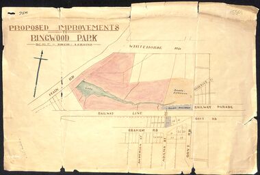
Map, Proposed Improvements to Ringwood Park (Ringwood Lake) dated 14 January 1927
Proposed Improvements to Ringwood Park (Ringwood Lake) dated 14 January 1927, signed Cr McCaskill. Main Road is Whitehorse Road (Maroondah Highway), and Mt Dandenong Road is incorrectly labelled Whitehorse Road. The map shows Rosedale Crescent and Railway Parade, both of which exist in 2024. On the bottom of the map, south of the railway line, showing proposed streets - Graham Road, Anderson Street and Adams Street - in preparation for the sale of the Theo Anderson property. That area is now Bedford Park. -
 City of Moorabbin Historical Society (Operating the Box Cottage Museum)
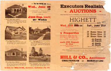
Flyer - Executors Realising Auction for land in Highett, 1941
The Great Depression of Australia halted the sale of land in most circumstances - this sale was just after the end of the depression years of 1930 to 1939.Example of the progress of the Municipality of MoorabbinAdvertising flyer for auction of real estate sales - plan of building blocks for saleSale of land in Highett - Hill & Co (A. W. Hill, Auctioneer) - brochure has pictures of the houses on the properties being offered for saleviola crescent, wickham road, henry street, real estate, highett, moorabbin, auctions, benjamin lowden -
 City of Moorabbin Historical Society (Operating the Box Cottage Museum)
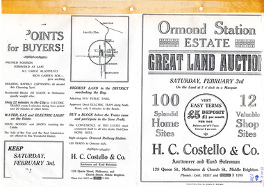
Flyer - Ormond Station Estate, Ormond, 1923
At the end of World War One, there was a renewed interest in residential land and a number of estates opened up in the Municipality of Moorabbin.Example of the progress of the Municipality of MoorabbinAdvertising flyer for auction of real estate sales - plan of building blocks for saleOrmond Station Estate, Ormond - Great Land Auction - 100 Home sites 12 shop sites - Auction Saturday 3rd February 1923malane st, foch st, coane st, beatty crescent, ormond, real estate, auction -
 Port Melbourne Historical & Preservation Society
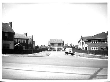
Photograph - Dunstan Estate during construction, Port Melbourne, Department of Public Works, 1936
Twenty five (25) black and white or sepia photographs of the houses of the Dunstan Estate during their building i.e. Griffin Crescent and Southwood Avenue .05-.15 - smaller photographs, mainly of individual houses Taken in 1936, some cars shown parked in streetsbuilt environment - domestic, domestic life, department of public works, dunstan estate, percy e everett, henry pye, albert dunstan -
Port Melbourne Historical & Preservation Society
Photograph - Houses during construction on Dunstan Estate, Port Melbourne, Department of Public Works, 1936
Twenty five (25) black and white or sepia photographs of the houses of the Dunstan Estate during their building i.e. Griffin Crescent and Southwood Avenue .01 - sheet with 9 photos later enlarged as individual images Taken in 1936, some cars shown parked in streetsbuilt environment - domestic, domestic life, department of public works, dunstan estate, everett, percy e, pye, henry, dunstan, albert -
Port Melbourne Historical & Preservation Society
Photograph - Houses during construction on Dunstan Estate, Port Melbourne, Department of Public Works, 1936
Twenty five (25) black and white or sepia photographs of the houses of the Dunstan Estate during their building i.e. Griffin Crescent and Southwood Avenue .02 - sheet with 9 photos later enlarged as individual images Taken in 1936, some cars shown parked in streetspercy e everett, henry pye, albert dunstan, dunstan estate, department of public works, built environment - domestic, domestic life -
Port Melbourne Historical & Preservation Society
Photograph - Houses during construction on Dunstan Estate, Port Melbourne, Department of Public Works, 1936
Twenty five (25) black and white or sepia photographs of the houses of the Dunstan Estate during their building i.e. Griffin Crescent and Southwood Avenue .03 - sheet with 6 photos later enlarged as individual images Taken in 1936, some cars shown parked in streetsbuilt environment - domestic, domestic life, department of public works, dunstan estate, percy e everett, henry pye, albert dunstan -
 Port Melbourne Historical & Preservation Society
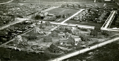
Photograph - Aerial view of houses during construction on Dunstan Estate, Port Melbourne, Department of Public Works, 1936
Twenty five (25) black and white or sepia photographs of the houses of the Dunstan Estate during their construction i.e. Griffin Crescent and Southward Avenue .04 - Aerial photographs (also shows Graham St School) Taken in 1936, some cars shown parked in streetsbuilt environment - domestic, domestic life, department of public works, dunstan estate, percy e everett, henry pye, albert dunstan -
 Royal Australian and New Zealand College of Obstetricians & Gynaecologists (RANZCOG)
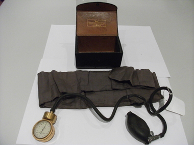
Sphygmomanometer used by Dr Henry William Devlin, Short & Mason Ltd, 1890s
Donated by Miss Beatrice May Devlin, items that belonged to her paternal grandfather, Dr Henry William Devlin graduated in Medicine from Dublin, worked at the Rotunda hospital, Dublin. He immigrated to Australia and was the first doctor to practice in Parkes NSW.Sphygmomanometer,"Tyco", manufacturer; Short and Mason Ltd London brand, complete and excellent condition in original case. -
 Royal Australian and New Zealand College of Obstetricians & Gynaecologists (RANZCOG)
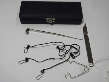
Instrument case with unidentified instruments
Donated by Miss Beatrice May Devlin, items that belonged to her paternal grandfather, Dr Henry William Devlin who graduated in Medicine from Dublin and worked at the Rotunda hospital, Dublin. He immigrated to Australia and was the first doctor to practise in Parkes NSW.Please refer to supplementary file filed under Accession number 1995001Instrument case, small, containing small silver knife, a small silver ladel with a sharp probe at one end, a tweezeer like instument and string with three hook attachments. Looks unused, not gynaecological, nasal?dr henry william devlin -
 Royal Australian and New Zealand College of Obstetricians & Gynaecologists (RANZCOG)
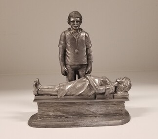
Sculpture - Pewter vignette of an obstetrician observing an antenatal patient, Michael Ricker Pewter
Michael Ricker was a renowned American pewter artist. His most famous piece, entitled 'Park City', was a 30 foot by 10 foot miniature town depicting life at the turn of the 19th century. It was completed in 1986 and presented to former President Gerald Ford. Ford graciously accepted the "key" to Park City and promised a home for the masterpiece in the Smithsonian Institute. (foundantique.com)Pewter sculpture featuring an obstetrician and an antenatal patient. A pregnant woman is lying on a low bench, with her left hand resting on her stomach, and her right arm by her side. She is wearing a dress and shoes, and has her eyes closed. To her right stands the figure of on obstetrician, wearing trousers, a short sleeved shirt, stethoscope and gloves. He is standing straight with his arms at his sides. The entire sculpture is silver in colour.obstetrics -
 Sunshine and District Historical Society Incorporated
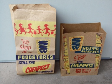
Brown Paper Grocery Bags
These type of brown paper grocery bags were commonly supplied by SSW Supermarkets, and also by other Supermarkets. The customers generally packed their own grocery purchases into the bags, while the checkout people were engaged in the time consuming process of accurately entering by hand, the price of each item into the cash registers. One local SSW Supermarket was situated on Sun Crescent in Sunshine. The introduction of stronger plastic film grocery bags and barcode scanning saved time, and the checkout person took over the role of packing the grocery purchases. In recent times customers who use the self check out terminals have again assumed the role of packing their own groceries. The environment polluting plastic bags however still remain, unless the customers bring their own 'green' bags.These two brown paper grocery bags provide a historical reminder of how grocery purchases were taken home from Supermarkets in the not too distant past. It is likely that many of the younger generation have no idea of how the paper grocery bags looked like, or that they were once used instead of plastic bags.Two brown paper bags which were available for free in SSW Supermarkets, so that customers could pack their grocery purchases to be able to take them home. The bags have SSW advertising printed on them in red, yellow, and navy blue inks.Large Bag: We Shop at .... SSW FOODSTORES STILL THE CHEAPEST DAY IN, DAY OUT! Smaller Bag: SSW SUPERMARKETS Still THE CHEAPEST DAY IN .... DAY OUT!brown paper grocery bag, ssw supermarket, food, grocery purchases, groceries. -
 Whitehorse Historical Society Inc.
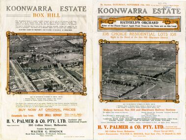
Document - Real Estate Notice, Koonwarra Estate Hatfield's Orchard, C1924
Land brochure giving details of auction of Koonwarra EstateLand brochure giving details of auction of Koonwarra Estate known as Hatfield's OrchardLand brochure giving details of auction of Koonwarra Estate land sales, koonwarra estate, hatfield's orchard, middleborough road, blackburn, canterbury road, laburnum street, hillside crescent, salisbury avenue, rymer street, pakenham street, park street, myrtle grove, h. v. palmer & co. pty. ltd., hiscock, walter g -
 Whitehorse Historical Society Inc.
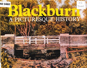
Book - Chronicle, Blackburn, A Picturesque History, 1978
A chronicle of Blackburn with photographs, diagrams and maps from the 1850's onwards.A chronicle of Blackburn with photographs, diagrams and maps from the 1850's onwards.non-fictionA chronicle of Blackburn with photographs, diagrams and maps from the 1850's onwards.open air school blackburn no3850, blackburn., morton park, traveller's rest hotel, blackburn lake sanctuary, blackburn creek hotel, blackburn road blackburn, blackburn post office, blue moon fruit co-operative ltd, blackburn railway station, pioneers, gordon crescent blackburn, lake road blackburn, goodwin george augustus, morton thomas richards burrowes, st johns anglican church blackburn, blackburn methodist church, blackburn church of christ, blackburn primary school no 2923, blackburn scout group 1st, blackburn and district tree preservation society, g.f. fankhauser -
Whitehorse Historical Society Inc.
Article, An open or shut case
After Nunawading Council rejecting Club 25's appeal for a planning permit for a brothel in Mitcham.After Nunawading Council rejecting Club 25's appeal for a planning permit for a brothel in Mitcham. Owner of the brothel, Bruce Roberts, has appealed to the Planning Appeals Tribunal and his appeal is to be heard 20 September. A new group has been set up and funds raised from St John's Catholic Church, Mitcham, Brothel Action Reform Group to support the anti-brothel group and have engaged legal experts.After Nunawading Council rejecting Club 25's appeal for a planning permit for a brothel in Mitcham. brothels, st johns catholic church, mitcham, rossiter, bob, wattle park gospel chapel, watson, al, roberts, bruce, club 25, brothel action reform group, galbally, frank, victoria. planning appeals board., thornton crescent -
 Whitehorse Historical Society Inc.
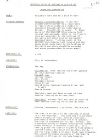
Document, Landscape Submission, c 1976
A landscape submission written for the National Trust of Australia (Victoria) for Blackburn Lake and the Bell Bird Streets.A landscape submission written for the National Trust of Australia (Victoria) for Blackburn Lake and the Bell Bird Streets. Definitions given of boundaries of the Lake area, ownership, housing and gardens. Photographs and map.A landscape submission written for the National Trust of Australia (Victoria) for Blackburn Lake and the Bell Bird Streets.blackburn lake sanctuary, waratah crescent, blackburn, jeffery street, hill street, boongarry avenue, linum street, laurel grove, acacia avenue, city of nunawading, melbourne and metropolitan board of works, furness park, camberwell grammar school -
Whitehorse Historical Society Inc.
Article, Development threatens to bury famous artistic site, 2006
Residents have made a last-ditch call for the Federal Government to stop development on land where Frederick McCubbin painted his famous work 'Bush Burial' in 1890Residents have made a last-ditch call for the Federal Government to stop development on land where Frederick McCubbin painted his famous work 'Bush Burial' in 1890 (Photo of painting plus David McCubbin)Residents have made a last-ditch call for the Federal Government to stop development on land where Frederick McCubbin painted his famous work 'Bush Burial' in 1890blackburn lake sanctuary, mccubbin, frederick, mccubbin, david, wolseley crescent, blackburn, blackburn lake environmental education park committee, city of whitehorse, seventh day adventist church nunawading -
Whitehorse Historical Society Inc.
Mixed media - Living, investing, growing, Whitehorse City
Video - Living, Investing, Growing - Produced by City o Whitehorse, Opening words by Chief Commissioner, Geoff Oscar 1995. Shows aspects of city - Gordon Crescent, Blackburn Lake, Schools, Tally Ho Business Park, major businesses and retailers, Bruce Thompson Managing Director, Hewlett Packard, Simon Ho, Hong Kong Bank, Felicity Mason Lend Lease, Maroondah Transport corridor, Forest Hill Chase, Sport, Box Hill Community Art Space, Alan Stockdale, Treasurer, Victoria.oscar geoff - chief commissioner, gordon crescent blackburn, maroondah transport corridor, blackburn lake, forest hill chase, box hill community art space, tally ho business park, alan stockdale - treasurer of victoria, bruce thjompson - managing director hewlett packard, ho simon hong kong bank, city of whitehorse mason felicity lend lease -
 Mt Dandenong & District Historical Society Inc.
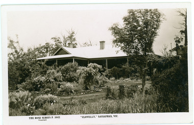
Photograph, Clovelly, c1920s
Clovelly Guest House was formerly Braco Park Guest House, owned and run by Eliza and Grace Murdoch. The original Guest House 'Clovelly' , owned by Mrs. Techow, was situated in The Crescent at Sassafras. After it burned down in 1921, Mrs. Techow purchased Braco Park and renamed it Clovelly. The site was purchased by the Education Department c1985 and is now Sherbrooke Community School. B & W Rose Series Postcard showing Front/Side view of Clovelly Guest House (formerly Braco Park) in Sassafras.The Rose Series P. 3942. "CLOVELLY" SASSAFRAS, VICclovelly, techow, murdoch, braco park, sherbrooke community school, guest house -
 Tennis Australia
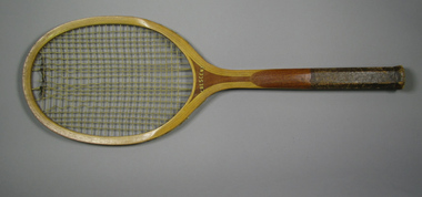
Racquet, Circa 1907
A Crescent tennis racquet, with cork inlaid handle grip. Possibly associated with the Crescent Athletic Club. Materials: Wood, Lacquer, Glue, Metal, Leather, Ink, Cork, Gut, Stringtennis -
 Bayside Gallery - Bayside City Council Art & Heritage Collection
Photograph, Department of Crown Lands and Survey, Victoria, Melbourne Project: Brighton, 1976
The Department of Crown Lands and Survey (1857-1983) was responsible for the administration of survey and mapping and the sale, occupation and management of crown land throughout its existence. This aerial photograph shows parts of Brighton and was taken on 1 December 1976brighton, department of crown lands and survey, aerial photograph, bayside, port phillip bay, map, cartographic material, melbourne project 1976, brighton yacht club, middle brighton baths, north road, st kilda street, new street -
 Tennis Australia
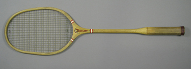
Racquet, Circa 1925
An Horace Partridge Crescent badminton racquet, with plastic ribbon whipping around shoulders and shaft, and fine-grooved handle. Materials: Wood, Nylon, Leather, Glue, Lacquer, Metal, String, Plastic, Ink, Clothtennis -
 Tennis Australia
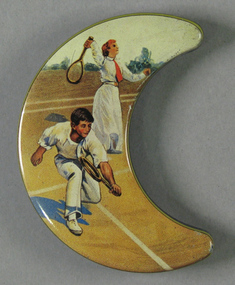
Decorative object, Circa 1985
... Park Melbourne melbourne Tennis Crescent shaped tin decorated ...Crescent shaped tin decorated with scene of man and woman playing tennis. Materials: Metal, Inktennis -
 Kew Historical Society Inc
Plan, Studley Heights Estate, 1936
... in the subdivision fronted Hyton Crescent and Studley Park Road....’ on the South Side of Studley Park Road was launched in 1936 ...Pru Sanderson, in her groundbreaking ‘City of Kew Urban Conservation Study : Volume 2 - Development History’ (1988), summarised the periods of urban development and subdivisions of land in Kew. The periods that she identified included 1845-1880, 1880-1893, 1893-1921, 1921-1933, 1933-1943, and Post-War Development. These periods were selected as they represented periods of rapid growth or decline in urban development. An obvious starting point for Sanderson’s groupings involved population growth and the associated economic cycles. These cycles also highlighted urban expansion onto land that was predominantly rural, although in other cases it represented the decline and breakup of large estates. A number of the plans in the Kew Historical Society’s collection can also be found in other collections, such as those of the State Library of Victoria and the Boroondara Library Service. A number are however unique to the collection.Subdivision plans are historically important documents used as evidence of the growth of suburbs in Australia. They frequently provide information about when the land was sold on which a built structure was subsequently constructed as well as evidence relating to surveyors and real estate and financial agents. The numerous subdivision plans in the Kew Historical Society's collection represent working documents, ranging from the initial sketches made in planning a subdivision to printed plans on which auctioneers or agents listed the prices for which individual lots were sold. In a number of cases, the reverse of a subdivision plan in the collection includes a photograph of a house that was also for sale by the agent. These photographs provide significant heritage information relating house design and decoration, fencing and household gardens.The ‘Studley Heights Estate’ on the South Side of Studley Park Road was launched in 1936. The seventeen allotments in the subdivision fronted Hyton Crescent and Studley Park Road.subdivision plans - kew, studley heights estate