Showing 99 items matching " point nepean road"
-
 Glen Eira Historical Society
Document - Roseneath, Nepean Highway, 31, Elsternwick
... Point Nepean Road... Highway McMillan Street Point Nepean Road Rusden Street ...A photocopy of a Caulfield Conservation Study conducted in January 1995 by historian Andrew Ward of the house Roseneath named thus by 1904. The document includes a photocopied photograph of the front façade, although the features are unclear. The document, which includes a bibliography, details the history of Roseneath, including owners and occupiers, as well as the architectural features of significance and historical value.ward andrew, millar william, boyle andrew, worthington george, tulloch annie, cross anastasia, meek alex, caulfield, roseneath, elsternwick, nepean highway, mcmillan street, point nepean road, rusden street, cumbernauld, hawthorn road, glenmoore, st. georges road, caulfield south, shire of caulfield, east st. kilda riding, historic buildings register, national trust register, national estate register, italianate style, architectural styles, architectural features, mansions, brick houses, verandahs, cast iron work, bluestone, bay windows, land subdivisions, merchants, judges, leases, councillors -
Glen Eira Historical Society
Letter - St. James Parade, 11, Elsternwick
... Point Nepean Road... Nepean Road Adami Lillian Jean House Elsternwick Scott Wv St ...Five documents all relating to the estate of Lillian Jean Adami of 11 St James Street, Elsternwick A request for a sworn valuation on the auction price for the property and the contents from office of Public Trustee. A carbon copy of sworn valuation of the property and contents by Wv Scott FCIV. Includes an inventory and valuation of furniture and effects on and about the property, working notes on the valuation of the building and a copy of the Certificate title for Lot 16 subdivision 9341 on the western side of St. James Parade, Elsternwick Vol 5268. Folio 496 includes site plan and encumbrances referral.simmons s.p., plans, point nepean road, adami lillian jean, house, elsternwick, scott wv, st. james parade, prahan, estate agents, county of bourke -
Glen Eira Historical Society
Book - Local Government Act First Report of the Assistant Commissioner of Roads and Bridges
... Point Nepean Road... Moorabbin Road Districts Point Nepean Road Nepean Highway Dandenong ...This file contains 1 item: 1/The Local Government Act, First Report of the Assistant Commissioner of Roads and Bridges, printed by order of the Victorian Legislative Assembly on 08/03/1865. The document is the first annual report of John Steavenson, Assistant Commissioner of Roads and Bridges under s330 of the Local Government Act no. 176 (1863), and relates to transactions which took place from 02/09/1863 to 31/12/1864. The report outlines operations carried out by the Department of Roads and Bridges in this period. In the Glen Eira area this includes: separating electoral subdivisions of single districts (Moorabbin), adding detached portions of territory to road districts and shires (Caulfield), appointing of and altering in polling places, appointing of polling places for ridings of shires and subdivisions of road districts (Moorabbin), preparing and transmitting of forms of books also of pro forma accounts for guidance of local bodies in keeping their accounts, appointment of main roads, construction of a main road, ‘Dandenong’, in the Caulfield and Gardiner districts, proclaiming of Common Toll Roads, names of and security given by Managers of Common Toll Roads. The report also gives some information about the Shire of Caulfield, which contained 24 road districts and 340 rate payers in 8¼ square miles, and the Shire of Moorabbin, which contained 62 road districts and 713 rate payers in 30 square miles.local government act, assistant commissioner of roads and bridges, legislative council, caulfield historical soceity, steavenson john, sullivan j. f. the honourable, caulfield, moorabbin, road districts, point nepean road, nepean highway, dandenong road, princes highway, brown edwin, osher joseph, cosgrove john, ferres john, roads and bridges offices, caulfield roads district, moorabbin roads district, road construction and maintenance, roads and streets, acts of parliament -
Glen Eira Historical Society
Article - ELSTERNWICK RAILWAY STATION AND LINE
... Point Nepean Road... Progress League Point Nepean Road Newspapers Caulfield Council ...Contains three items about this: 1/A photocopied article (across 3 long columns) from the Southern Cross newspaper dated 21/07/1928. The article contains details of the opening of the Gardenvale Martin Street subway ceremony. Mention is made of the Caulfield Council’s spontaneous assistance, harmony working alongside Brighton and their financial assistance, as well. Councillor E.F. England (Mayor of Caulfield) attended on behalf of the Caulfield Council. He referred to the large patronage on the Brighton line, also mentioning similar issues for the Elsternwick level crossing. There are brief summaries from the many speakers. The pupils from Gardenvale and Elsternwick schools were congregated around the subway, and the Brighton municipal Brass Band rendered selections. 2/Newspaper clipping (source not stated perhaps Melbourne Sun), ‘Elsternwick to get underpass’, dated 25/02/1959, stating that ‘work has begun to build an underpass that will abolish the Glenhuntly Road level crossing’, with photograph and a map of the level crossing. 3/Handwritten note, signed ‘FEC, 17/11/2006’, headed ‘To be researched – Shooting in foot underpass-policeman killed-murder last man to be hanged in Victoria’, with note on Glenhuntly Road underpass.‘southern cross’, gardenvale progress league, point nepean road, newspapers, caulfield council, north road, ‘made in australia’ week, railways department, parliamentary representative, railway crossings, councillors, gardenvale school, elsternwick school, schools, market gardens, gardenvale progress association, england e.f.(mayor), elsternwick, caulfield, hoyts theatre, theatres, glenhuntly road, elsternwick station, police, murders, executions, shops, elsternwick plaza, petrol stations, ‘the hub’, flats, brothels, ‘the daily planet’ (sic), car parks -
Glen Eira Historical Society
Article - McMillan Street, 14, Elsternwick
... Point Nepean Road... Apartments McMillan Street Elsternwick Bell J. Mrs. Point Nepean Road ...Two items in this file. Three real estate advertisements in The Leader Newspaper dated 07/09/2002, 04/11/2000 and 14/07/2003 for flats 27, 21, and 19. Additional research by Joan Moore 09/10/2012 from Sands and McDougall’s Directories on property previously called Sherbrooke.sherbrooke, house names, apartments, mcmillan street, elsternwick, bell j. mrs., point nepean road, horne street, jones ernest, agg cyril, noel anthony, sherbrooke flats -
Glen Eira Historical Society
Letter - Lempriere Family
... Point Nepean Road Lempriere John T Gardenvale Station estate... Kooyong Road Point Nepean Road Lempriere John T Gardenvale Station ...Four items about the Gardenvale Station Estate: 1. Photocopy of correspondence dated 19/11/1925 to the Town Clerk from C A Lempriere regarding a photograph at Gardenvale railway station estate : land previously owned by John T Lempriere (former mayor). 2. Photocopy of photograph showing Gardenvale station estate land before subdivision. 3. Document of thanks from Councillors re photograph in minutes ref. 2362-25. 4. Photocopied photo, with brief text about auction and of view of the Gardenvale Station Estate.lempriere c a gardenvale railway station kooyong road point nepean road lempriere john t gardenvale station estate subdivisions , hall councillor , wharington councillor, mackay g j (auctioneer), houses -
Glen Eira Historical Society
Document - KELLY FAMILY
... Point Nepean Road... Kelly Matthew Patrick St Georges Road Point Nepean Road Cochrane ...This file contains two items about this family: 1/Printout of a webpage from museumvictoria.com.au entitled ‘Digital Photograph – Man & Woman in Horse Driven Buggy, Elwood Park, circa 1917’. The image is of Matthew and Jeanette Kelly driving a horse drawn buggy in Elwood Park, circa 1917. The content description also mentions that Matthew Kelly was a saddler in his father John Kelly’s saddlery business. 2/Typed sheet entitled ‘Research findings for Matthew Robert Kelly’ dated July 2014 by Margaret Dunbar on behalf of GEHS. It shows information from the Victorian Births, Deaths & Marriages records plus Electoral Rolls between 1909 and 1942 and has three addresses for Matthew Robert Kelly in Elsternwick. Details of other family members included.elwood park, kelly matthew robert, kelly jeanette veronica, elster park, elsternwick, kelly john, nepean highway, golf courses, kelly elizabeth, acreman alice maud mary, sportsgrounds, saddleries, saddlers, telephonist, horse-drawn vehicles, kelly veronica, brady veronica, kelly jeanetta, brady jeanetta, brady nita, kelly alice theresa, kelly james michael, kelly margaret ann, kelly mary elizabeth, kelly catherine agatha, kelly helena alphonsus, kelly alice, kelly matthew patrick, st georges road, point nepean road, cochrane street, parks and reserves -
 City of Moorabbin Historical Society (Operating the Box Cottage Museum)
Newsletter, City of Moorabbin Historical Society Jun 2008, June 2008
... point nepean road... post office point nepean road sports moorabbin show processions ...The City of Moorabbin Historical Society was formed c 1960 by a group of Moorabbin residents who were concerned that the history of the area should be preserved. A good response to a call for items related to the historical area of Moorabbin Shire brought donations of a wide variety of artefacts which are now preserved by the current members of CMHS at Box Cottage Museum . Helen Stanley, Secretary of CMHS, began producing a Newsletter for members in April 2007 to provide current information and well researched items of historical interest.Helen Stanley has produced a bi-monthly Newsletter, 2007 - 2013, for the members of the City of Moorabbin Historical Society that contains well researched interesting historical items, notification of upcoming events, current advice from Royal Australian Historical Society , Museums Australia Victoria and activities of Local Historical Societies. The Newsletter is an important record of the activities of the CMHS. Tom Sheehy, past President of CMHS, was an Historian and Author of ‘Battlers Tamed the Sandbelt’. A4 paper printed both sides x1. Issue 7 of the bi-monthly, City of Moorabbin Historical Society Newsletter produced by Society member and Secretary, Mrs Helen Stanley in June 2008. Notice for meeting June 29th and August 31st at which Ms Dorothy Booth’s topic will be ‘The Historical Mentone Railway Gardens’. Another excerpt from the CMHS Newsletter November 1965, by Tom Sheehy, President, called ‘Memories of Old Cheltenham’ This is the story ‘as told’ to Tom Sheehy by Jack McCarthy b 1890, a member of CMHS, and includes a photocopied photograph of passengers on SS Hygeia c 1900 on a trip across the Bay to the Geelong area. CITY of MOORABBIN HISTORICAL SOCIETY / JUNE 2008 NEWSLETTERcity of moorabbin historical society, stanley helen, melbourne, moorabbin, brighton, chelsea, cheltenham, ormond, bentleigh, market gardeners, pioneers, early settlers, moorabbin shire, sheehy tom, box cottage museum, highett, cheltenham railway station victoria, mccarthy jack, power maurice j., charman road state school, standard certificate education, cheltenham post office, point nepean road, sports, moorabbin show, processions, parades, mentone ice skating rink, sheperd’s café, bourke street, horse tram, sandringham, beach road, ss hygeia, ss courier, ss edina, mechanics hall, memorial hall, magic lantern shows, crooks mr., engine drivers strike 1903, park road cheltenham, booth dorothy, mentone railway station gardens -
 City of Moorabbin Historical Society (Operating the Box Cottage Museum)
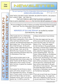
Flyer - Hill Estate, Highett
... Point Nepean Road (Nepean Highway)... of the Municipality of Moorabbin Point Nepean Road (Nepean Highway) Turner ...Land sales in the Municipality of Moorabbin increased when the train line from the City to Frankston was electrified.Example of the progress of the Municipality of MoorabbinAdvertising flyer for auction of real estate sales - plan of building blocks for saleThe Hill Estate, Highett - 24 Housing Blocks - J. F. Bradypoint nepean road (nepean highway), turner street, sanford street, real estate, highett -
 City of Moorabbin Historical Society (Operating the Box Cottage Museum)
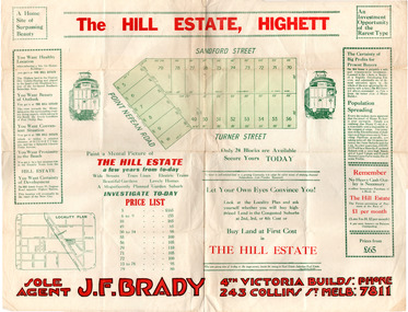
Flyer - The Hill Estate, Highett, 1917
... Point Nepean Road (Nepean Highway)... Point Nepean Road (Nepean Highway) Turner Street Sanford Street ...The land sales in the area stopped due to the 1890s depression. For the next 20 years real estate sales virtually stopped until after WWI.Example of the progress of the Municipality of MoorabbinAdvertising flyer for auction of real estate sales - plan of building blocks for saleThe Hill Estate, Highett - 110 allotments - Auction Saturday September 22, 1917 T.R.B. Morton & Sonpoint nepean road (nepean highway), turner street, sanford street, alfred street, peace street, highett, real estate, moorabbin -
 City of Moorabbin Historical Society (Operating the Box Cottage Museum)
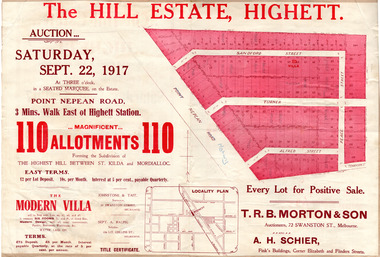
Flyer - Moorabbin Heights Estate, Moorabbin, 1929
... Point Nepean Road (Nepean Highway)... of the progress of the Municipality of Moorabbin Point Nepean Road (Nepean ...The train line from the city to Frankston was electrified which intensified the sale in the municipality of Moorabbin, particularly land which was in the vicinity of the railway stations.Example of the progress of the Municipality of MoorabbinAdvertising flyer for auction of real estate sales - plan of building blocks for saleMoorabbin Heights Estate, Moorabbin 48 Villa sties, 21 Shop sites Sale on Saturday 13 April 1929 - H. C. Costello & CO.point nepean road (nepean highway), harding street, howell street, north avenue, coates street -
 City of Moorabbin Historical Society (Operating the Box Cottage Museum)
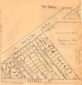
Plan - Highlands Estate, Moorabbin
... Point Nepean Road (Nepean Highway)... of the progress of the Municipality of Moorabbin Point Nepean Road (Nepean ...The train line from the city to Frankston was electrified in 1922 which intensified the sale in the municipality of Moorabbin, particularly land which was in the vicinity of the railway stations. This estate was auctioned on Saturday, October 20, 1923.Example of the progress of the Municipality of MoorabbinAdvertising flyer for auction of real estate sales - plan of building blocks for saleHighlands Estate, Moorabbin plan.point nepean road (nepean highway), schofield street, taverner street, herbert street (now linton street), moorabbin, real estate, auction -
 City of Moorabbin Historical Society (Operating the Box Cottage Museum)
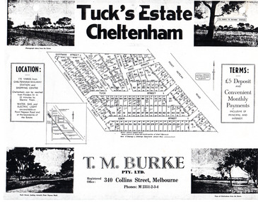
Flyer - Tuck's Estate, Cheltenham, 1940
... Point Nepean Road... Nepean Road Eden Street Tuck Street Hoffman Street Elman Road ...After WWII there was a decline in the market gardens in the City of Moorabbin, as the value of the land was more profitable than the crops.Example of the progress of the Municipality of MoorabbinPhotocopy of advertising flyer for sale of real estate sales - plan of building blocks for saleTuck's Estate Cheltenham - plan of subdivisionedward street, point nepean road, eden street, tuck street, hoffman street, elman road, page street, cheltenham, real estates, auction, tuck -
 Chelsea & District Historical Society Inc
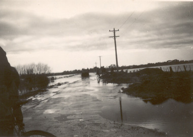
Photograph - Chelsea Flood December 1934, Wells Road, Chelsea
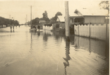
... Point Nepean Road.... flood chelsea Dandenong Creek Nepean Highway Point Nepean Road ...In December 1934, 700 houses were inundated with water, when the Dandenong Creek and Patterson River broke their banks.Three Black and white photo of flood waters across Wells Road, Chelsea. A SEC truck can be see travelling down Wells Road in photo one and two, with people viewing the flooded street.flood, chelsea, dandenong creek, nepean highway, point nepean road -
 Chelsea & District Historical Society Inc
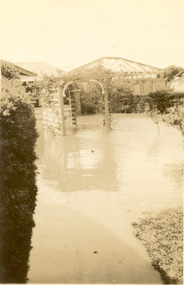
Photograph - Chelsea Flood December 1934, Carrum Hotel, Nepean Highway
... Point Nepean Road.... flood chelsea Dandenong Creek Nepean Highway Point Nepean Road ...In December 1934, 700 houses were inundated with water, when the Dandenong Creek and Patterson River broke their banks.Black and white photo of flood waters in the garden of Carrum Hotel, showing an archway and in the background is a partially built building.flood, chelsea, dandenong creek, nepean highway, point nepean road, carrum hotel -
 Chelsea & District Historical Society Inc
Photograph - Chelsea Flood December 1934
... Point Nepean Road.... flood chelsea Dandenong Creek Nepean Highway Point Nepean Road ...In December 1934, 700 houses were inundated with water, when the Dandenong Creek and Patterson River broke their banks.Two Black and white photo of flood waters in Chelsea. flood, chelsea, dandenong creek, nepean highway, point nepean road -
 Chelsea & District Historical Society Inc
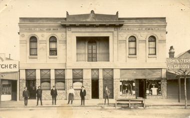
Photograph - Chelsea Shops, Butcher shop - Chelsea Wine Bar - Upholsterer, 1920's
... Point Nepean road.... Chelsea Chelsea Wine Cafe Point Nepean road Nepean Highway Chelsea ...The Chelsea Wine Cafe was situated in Point Nepean Highway opposite the Chelsea railway station. It offered meals, accommodation and wine. In late 1936 the building was pulled down.Two black and white photos of Chelsea Wine Cafe also in the photos are a butcher shop and an upholsterer.Chelsea Wine Cafe Cash Butcher Upholsterer - All classes of Furniture chelsea, chelsea wine cafe, point nepean road, nepean highway -
 City of Kingston
Pamphlet - Colour, Moorabbin News Print, Auction = Sale Heather Grove Estate, c. 1914
... , Railway Parade, Highett Road and Point Nepean Road.... Parade, Highett Road and Point Nepean Road. Auction = Sale ...Sales plan for land in the suburb of Cheltenham, bounded by Tulip Grove and Heather Grove.The developing urban area of Highett within the City of Kingston. This land sale pamphlet illustrates the subdivision of land within the municipality and the changing demographic of the district as new houses are constructed close to infrastructure.Colour pamphlet advertising auction of Heather Grove Estate, Cheltenham. Incorporates a map of the estate bordered by Wickham Road, Railway Parade, Highett Road and Point Nepean Road.Handwritten in grey pencil on subdivision 1: Sold / 20/- Handwritten in grey pencil on subdivision 2: 25/- Handwritten in grey pencil on subdivision 3: 30/- Handwritten in grey pencil on subdivision 4: 110 / 30/- Handwritten in grey pencil on subdivisions 1, 11, 10, 9 and 8: Sold Handwritten in grey pencil beneath 'Heather Grove': 20/- 20/- 20/- 20/- Handwritten in black ink on subdivison 12 and 7: £85 Handwritten in back ink on subdivision 5: £60 Handwritten in back ink on subdivision 6: £65 Handwritten in grey pencil above subdivision map: 1-8-9-10-11 Handwritten in grey pencil above subdivision map: [enclosed in a circle] 12- / £75 Handwritten in grey pencil above subdivision map: [enclosed in a circle] 2 / £85 Handwritten in grey pencil above subdivision map: [enclosed in a circle] 3 / £100 Handwritten in grey pencil above subdivision map: [enclosed in a circle] 4 / £100 Handwritten in grey pencil above subdivision map: [enclosed in a circle] 5 / £60 Handwritten in grey pencil above subdivision map: [enclosed in a circle] 6 / £65 Handwritten in grey pencil above subdivision map: [enclosed in a circle] 7 / £25- Handwritten in grey pencil above subdivision map: [enclosed in a circle] £125 / [indecipherable] Handwritten in grey pencil above subdivision map: 37.00 / 18.10 / 56.80 / 3 / [horizontal line] / 59 8 Handwritten in grey pencil along railway line marking: 21/6 / 12/6 / 13/- / 19/-land sales, estate, cheltenham -
 City of Kingston
Pamphlet - Colour, Highett Town, 1888
... by Wickham Road, Railway Parade, Highett Road and Point Nepean Road.... Parade, Highett Road and Point Nepean Road. Highett Town Pamphlet ...Sales plan for land in the suburb of Highett, bounded by Highett Road, Worthing Terrace and the railway line, and incorporating Major Street and Train Street.The developing urban area of Highett within the City of Kingston. This land sale pamphlet illustrates the subdivision of land within the municipality and the changing demographic of the district as new houses are constructed close to infrastructure.Colour pamphlet advertising for private sale the Station Entrance Estate, Highett. Incorporates a map of the estate bordered by Wickham Road, Railway Parade, Highett Road and Point Nepean Road.land sales, highett -
 City of Kingston
Pamphlet - Black and white, Robert McCamish & John Gilpin (Vendors), For Private Sale Station Entrance Estate, Highett, 1930s
... by Wickham Road, Railway Parade, Highett Road and Point Nepean Street. ... bordered by Wickham Road, Railway Parade, Highett Road and Point... by Wickham Road, Railway Parade, Highett Road and Point Nepean Street ...Sales plan for land in the suburb of Highett, bounded by Wickham Road, Railway Parade, Highett Road and Point Nepean Street. The developing urban area of Highett within the City of Kingston. This land sale pamphlet illustrates the subdivision of land within the municipality and the changing demographic of the district as new houses are constructed. The extension of the railway line from the city to Mordialloc opened up the land for development.Black and white pamphlet advertising for private sale the Station Entrance Estate, Highett. Incorporates a map of the estate bordered by Wickham Road, Railway Parade, Highett Road and Point Nepean Road. Handwritten in black ink on reverse: Station Entrance / Estate / Late [indecipherable]highett, land sales, estate -
 City of Kingston
Pamphlet - Colour, H. R. Hill & Co, Walker's Estate, Cheltenham for sale by public auction, c. 1923
... bordered by Wickham Road, Railway Parade, Highett Road and Point... Parade, Highett Road and Point Nepean Road. Walker's Estate ...Sales plan for land in the suburb of Cheltenham, encompassing both sides of Walker Grove, a section of Centre Dandenong Rd and Axelton St. The developing urban area of Cheltenham within the City of Kingston. This land sale pamphlet illustrates the subdivision of land within the municipality and the changing demographic of the district as new houses are constructed.Black and white pamphlet advertising for private sale the Station Entrance Estate, Highett. Incorporates a map of the estate bordered by Wickham Road, Railway Parade, Highett Road and Point Nepean Road.Handwritten in black pen on subdivision map: 'x' written on subdivisions 2, 3, 8-11, 15-17, 19. Potentially indicating that these properties did not sell at auction. Handwritten in black pen on subdivision map: assumed sale price on subdivisions 1, 4-7, 12-14, 18, 20-31. land sales, cheltenham, estate -
 Uniting Church Archives - Synod of Victoria
Document - Invitation, Methodist Homes for Children New Domestic Economy School
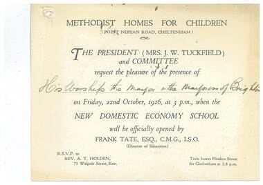
... at the Methodist Homes for Children, Point Nepean Road, Cheltenham... Nepean Road, Cheltenham. E3000.30.2 Copy of reply sent. Typed ...E3000.30.1 White card printed invitation to the Mayor and Mayoress of Brighton to the opening of the domestic economy school at the Methodist Homes for Children, Point Nepean Road, Cheltenham. E3000.30.2 Copy of reply sent. Typed on pink paper.methodist homes for children, tuckfield j w mrs, tate frank -
 City of Kingston
Photograph - Black and white, c. 1910
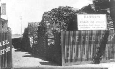
... Percy Wilson's woodyard was on Point Nepean Road... Parkdale Percy Wilson's woodyard was on Point Nepean Road ...Percy Wilson's woodyard was on Point Nepean Road, Cheltenham. Wilson was the local wood man and fuel merchant. Black and white image of a wood yard with a corrugated iron fence. Advertising is painted on to the fence, indicating they also sell briquettes. There is a sign on top of the fence including the business name, phone number and that it sells wood, coal, coke, and briquettes.cheltenham, wood, coal, briquettes, commerce, domestic -
 City of Kingston
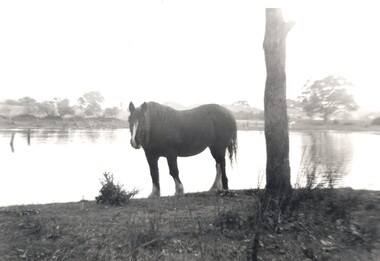
Photograph - Digital image, Black and white, c. 1950
... Street, looking towards Point Nepean Road.... Street, looking towards Point Nepean Road. This image shows ...Horse standing by a lake on the property of the Methodist Children's Homes, Cheltenham. The photograph is taken from Tennyson Street, looking towards Point Nepean Road.This image shows the land in Cheltenham, that later became Southland Shopping Centre. The land originally belonged to the Methodist Church, who operated a Children's Home on the property.Black and white image of a horse standing next to a tree trunk by a lake. cheltenham, methodist children's homes, southland, environment -
 Chelsea & District Historical Society Inc
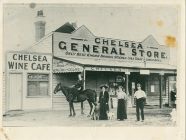
Photograph - Chelsea General Store - Chelsea Wine Cafe, 1910
... Wine Cafe on Point Nepean Road, Chelsea. In front of the shop... Nepean Road, Chelsea. In front of the shop is a girl on horse ...The Duncans sold the Chelsea General Store and Wine Cafe in 1914.Black and white photo of Chelsea General Store and Chelsea Wine Cafe on Point Nepean Road, Chelsea. In front of the shop is a girl on horse back, Ruby Campbell (nee Duncan), Honora Duncan (1861-1930), Olive (Ollie) Duncan and James (Jimmy) Duncan.CHELSEA GENERAL STORE ONLY BEST KNOWN BRANDS STOCKED - CASH TRADE AT LOWEST RATES ALL SUMMER DRINKS A SPECIALITY KEPT IN COOL BRICK CELLARS CHELSEA WINE CAFE - BAR M. DUNCAN LICENCEEchelsea general store, chelsea wine cafe, duncan, chelsea -
 Chelsea & District Historical Society Inc
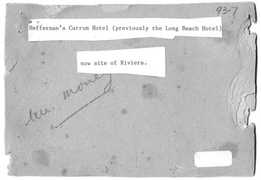
Photograph - Heffernan's Hotel, Carrum, c 1912
... situated in Point Nepean Road (now Nepean Highway). The hotel... situated in Point Nepean Road (now Nepean Highway). The hotel ...Thomas Heffernam (1860-1934) purchased the Carrum Hotel situated in Point Nepean Road (now Nepean Highway). The hotel was previously called Long Beach Hotel. The Riviera Hotel now occupies this site (2025).Black and white photo of a group of people standing in front of Carrum Hotel (Heffernan's), CarrumHeffernan's Carrum Hotel; Afternoon Teacarrum, seaford, carrum hotel, horse and cart, long beach hotel, riviera hotel, heffernan -
 Chelsea & District Historical Society Inc
Photograph - Chelsea Fire Brigade Members, c 1920
... of the station which was situated on Point Nepean Road. Four members... of the station which was situated on Point Nepean Road. Four members Have ...Members of the Chelsea Fire Brigade, standing in front of the station which was situated on Point Nepean Road. Four members Have been identified: Standing on ground from the right, Captain J. J. Smith, Frank Jennings, Mr Frickie, Zeke Smith.Black and White phot of the members of the Chelsea Fire Brigade standing in front of the of the Fire station and on the bell and hose tower.firefighters, chelsea, chelsea fire brigade, fireman, fire equipment -
 Chelsea & District Historical Society Inc
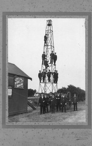
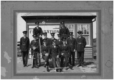
Photograph - Carrum Fire Brigade, Firemen, c 1918-20
... of the fire station which was situated in Point Nepean Road, Carrum... of the fire station which was situated in Point Nepean Road, Carrum ...Twelve members of the Carrum Fire Brigade standing in front of the fire station which was situated in Point Nepean Road, Carrum :- Back row - Harry Thompson, Les (Bud) Peters. Middle row - Ernie Bunn, Harold Barnes, Percy Tregent, Neil Mathieson, Alf Owen, Jack Owen, Larry Rentell. Front row - Alf Higgins, Alvie Symons, Fred Barnes (father of Harold).Black and white photo on backing board of 12 members of the Carrum Fire Brigade and some of their equipment standing in front of the Carrum Fire Station, a small weatherboard building on Point Nepean Highway.fire station, carrum fire brigade, firemen, fire equipment, chelsea -
 Brighton Historical Society
Coat, Dustcoat, c.1948
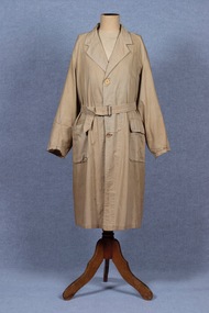
... managed a family grocery store circa 1948 at 510 Point Nepean Road... at 510 Point Nepean Road, East Brighton. Frederick was born ...Dust coat worn by Mr Frederick Alister Jennings when he managed a family grocery store circa 1948 at 510 Point Nepean Road, East Brighton. Frederick was born at Nagambie, Victoria in 1909 and died in Brighton in 1979. He was the son of Hugh Edwin Jennings and Alice Constance Warren. He married Margaret Jean Hughes in 1934 and served in the Second World War. He lived at 1 Valda Grove Brighton. Frederick was a commercial traveller as well as his time spent managing the store in Point Nepean Road. It is believed this coat dates from his time at the store c1948 - 1955. The store was owned for many years by his father-in-law W. G. Hughes and was one of a group of shops near the corner of Centre Road. In 1944-45 the group of shops included Fletcher’s fuel merchants, a haberdasher, butcher, fruiterer, grocer, Brighton East post office, a ladies’ hairdresser and Hughes’ grocer. In 1950 Hughes’ grocery store was between a service station and the Commercial Bank on what had been renamed Nepean Highway. The business was sold to G. S. Maynard, grocer, sometime before 1960.Unlined dustcoat of beige cotton. Fastens centre front with three brown plastic buttons. Two large patch pockets. Separate cloth belt with metal buckle. Signs of wear and mending. .1 - coat .2 -beltGarment label reads: APEX (RLG.) Dust Coat DEPT. MYER STORE for MEN. MELBOURNE & ADELAIDEdustcoat, occupational dress, grocer, hughes grocery store, brighton, frederick alister jennings -
 Glen Eira City Council History and Heritage Collection
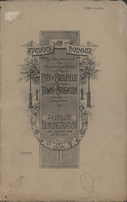
Booklet, D. W. Paterson Co. Pty. Ltd, "AVENUES OF HONOUR The Councils of the Municipalities of the CITY OF CAULFIELD TOWN OF BRIGHTON acting in conjunction PUBLIC DEMONSTRATION SAT 3rd AUG. 1918 AT 3oCLOCK SOUVENIR"
... on Brighton Road and Point Nepean Road. Souvenir programme... of the proposed Avenues of Honour on Brighton Road and Point Nepean Road ...Souvenir Programme from the Councils of the Municipalities of the City of Caulfield and the Town of Brighton for a Public Demonstration to be held on Sat 3rd August 1918 at 3 o'clock for the proposed Avenues of Honour to be planted in memory of fallen WWI soldiers. One of two known copies, this copy has "Town Clerk" stamped in the upper corner, rhs.Commemorative booklet, grey cover with text printed on the grey textured paper and an image of four trees and a wreath. Image of a kookaburra on the back. Inside, 28 numbered pages with b/w text and photographic images including a transparent paper representation of the proposed Avenues of Honour on Brighton Road and Point Nepean Road. Souvenir programme for a Public Demonstration for the Avenues of Honour as detailed on the front. From Honour Roll Display 2019 interpretation panel - Brighton-Caulfield Avenue of Honour It is hard to imagine but a grand arboreal Avenue of Honour once lined parts of North Road, McMillan Street and Point Nepean Road (now Nepean Highway). The Avenue of Honour was a distinctly Australian phenomenon with hundreds being constructed throughout Australia during and following World War One, most of these in Victoria. Consisting of tree lined streets with each tree representing a solider, the Avenue of Honour signalled a more egalitarian approach to commemoration where rank was not a consideration. Arguably the most famous Avenue of Honour in Victoria still exists at Ballarat. Stretching for nearly 22 kilometres, the entrance to the Avenue is marked by the imposing Arch of Victory. Smaller in scale, the Brighton-Caulfield Avenue of Honour was dedicated to the ‘memory of (Brighton and Caulfield’s) kith and kin who came from (the) district and who died in the Great War’. A joint project between the neighbouring Councils, the idea was first reported in The Argus on 1 July 1918. Plans moved along quickly and on 3 August 1918 the Governor of Victoria Arthur Stanley planted the first Australian flowering gum. The next of kin were then invited to plant trees for lost sons, brothers, uncles, nephews and husbands. In all, over 400 trees were planted. Intensely personal, the Avenue also acted as a focus of grief and remembrance for the wider community. For many years, the annual civic Anzac Day service was held at the Avenue on Point Nepean Road, near Glen Huntly Road, Elsternwick. The service was moved to Caulfield Park upon the completion of the Cenotaph in 1930. Due to road widening and disease the last original tree was replaced in the 1980s, however a plaque in Caulfield Park records the Avenue’s plantation. Inkstamp upper corner rhs: "TOWN CLERK"