Showing 6784 items matching " river"
-
 Port Fairy Historical Society Museum and Archives
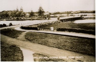
Postcard, The Rose Series / The Rose Stereographs, The Moyne River and bridge Port Fairy
Post card of the Moyne River BridgeBlack and white photograph of the Moyne river and Bridgehe Rose Series P. 10810 The Moyne River and Bridge, Port Fairybridge, moyne river, traffic, road -
 Port Fairy Historical Society Museum and Archives
Postcard, Valentine Publishing Co, The Bridge Moyne River Pt Fairy, 10.04.1929
Black and white Photograph of the bridge crossing the Moyne river with Gipps street in the foreground cleared land in the background taken for use as a postcardThe Bridge Moyne River Pt Fairymoyne bridge circa 1930, bridge, moyne river, river, road -
 Ballarat Heritage Services
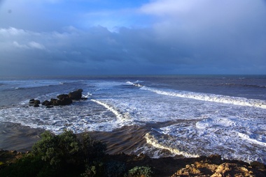
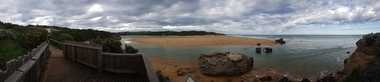
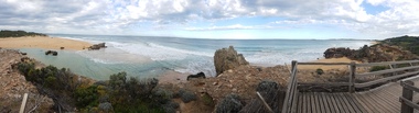
Photograph - Digital photographs, L.J. Gervasoni, Hopkins River Mouth in flood, c2010 - 2017
The flooded Hopkins River flows into the sea at Warrnambool.hopkins river, mouth, point ritchie, bluehole, warrnambool, coast, coastal, beach, seascape, flood -
 Ballarat Heritage Services
Digital photographs, L.J. Gervasoni, Hopkins River Mouth in flood as the waters receed, c2010 - 2017
Colour photograph of the mouth of the Hopkins River at Warrnambool,hopkins river, mouth, point ritchie, bluehole, warrnambool, coast, coastal, beach, seascape, flood, post flood, geology, coastal geomorphology, waters receeding -
 Ballarat Heritage Services
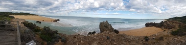
Digital photographs, L.J. Gervasoni, Hopkins River Mouth - panorama, c2010 - 2017
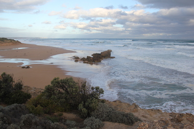
Panoramic photograph of the mouth of the Hopkin's River at Warrnambool.hopkins river, mouth, point ritchie, bluehole, warrnambool, coast, coastal, beach, seascape, coastal geomorphology, pano -
 Ballarat Heritage Services
Digital photographs, L.J. Gervasoni, Hopkins River Mouth - panorama, c2010 - 2017
Colour photograph of the mouth of the Hopkins River, Warrnambool.hopkins river, mouth, point ritchie, bluehole, warrnambool, coast, coastal, beach, seascape, coastal geomorphology, pano -
 Port Fairy Historical Society Museum and Archives
Postcard, Moyne River Port Fairy
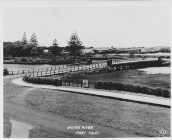
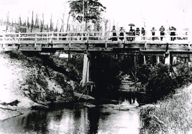
This bridge was built in 1902, replacing a previous structure that crossed the Moyne River from 1857 and linked Belfast with Belfast East, as the two areas of Port Fairy were then known. Prior to that, passage over the river was via a ford (an underwater stone track that allowed wagons to cross when the river was low) located just north of where the current car bridge stands. The present bridge survived the great flood of 1946, but has been the subject of innumerable patch-up jobs over its 114 years. In 2012, the bridge underwent a detailed structural assessment and was given the OK for the next eight to 10 years, notwithstanding the need for regular maintenance works. At the time, it was estimated a new bridge would cost between $2-3 million. It was extensively refurbished in 2016Sole means for traffic to cross to the east side of Port FairyBlack and white photographMoyne River Port Fairyriver, moyne, bridge, road -
 Ballarat Heritage Services
Digital photographs, L.J. Gervasoni, Hopkins River Mouth, c2010 - 2017
Three colour photographs of the mouth of the Hopkins River at Warrnambool.hopkins river, mouth, point ritchie, bluehole, warrnambool, coast, coastal, beach, seascape -
 Ballarat Heritage Services
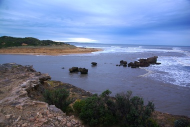
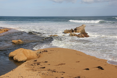
Digital photographs, L.J. Gervasoni, Hopkins River Mouth blocked, c2010 - 2017
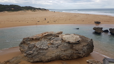
Colour photograph of the blocked mouth of the Hopkin's River at Warrnambool.hopkins river, mouth, point ritchie, bluehole, warrnambool, coast, coastal, beach, seascape, blocked -
 Ballarat Heritage Services
Digital photographs, L.J. Gervasoni, Hopkins River Mouth - panorama, c2010 - 2017
Colour photograph of the mouth of the Hopkin's River at Warrnambool, Victoria. hopkins river, mouth, point ritchie, bluehole, warrnambool, coast, coastal, beach, seascape, coastal geomorphology, pano -
 Ballarat Heritage Services
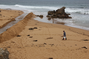
Digital photographs, L.J. Gervasoni, Hopkins River Mouth blocked - artificial channel, c2010 - 2017
Colour photograph of an rtificial chanel at the mouth of the Hopkin's River, Warrnambool. hopkins river, mouth, point ritchie, bluehole, warrnambool, coast, coastal, beach, seascape, blocked, digger, opening mouth, mechanical opening -
 Lakes Entrance Historical Society
Book, Stevens M I, Township of Cann River, Parish of Noorinbee, County of Croajingolong, 1977
An account of the development of the Cann River town and district in Gippsland, Victoria, compiled for the 50th. anniversary of the Cann River school. Includes list of pupils and head teachers, information on other schools, and recollections of residents.settlers, schools, township -
 Ballarat Heritage Services
Digital photographs, L.J. Gervasoni, Hopkins River Mouth blocked - artificial channel, c2010 - 2017
Colour photograph of an artificial chanel in the blocked mouth of the Hopkins River, Warrnambool. hopkins river, mouth, point ritchie, bluehole, warrnambool, coast, coastal, beach, seascape, blocked, digger, opening mouth, mechanical opening -
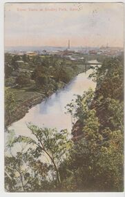
 Kew Historical Society Inc
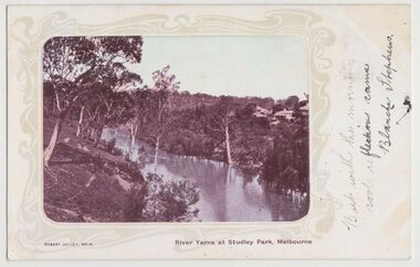
Postcard, River Yarra at Studley Park, Melbourne, 1900-04
Monochrome postcard titled lower right: “RIVER YARRA AT STUDLEY PARK, MELBOURNE”. The postcard was produced by ROBERT JOLLEY, MELB, (active 1900-1904). The photo is positioned to the left of the card and framed by an art nouveau design. A handwritten annotation on the front reads “BUT WITH THE MORNING / COOL REFLECTION CAME / BLANCHE STEPHENS”. On the reverse, there is a handwritten address in black ink to: MISS L STEPHENS / 26 WEST TERRACE / ADELAIDE. There is no division on the reverse of the postcard, dating it to before 1905. It lacks a postage stamp and postmark. Monochrome postcard of the River Yarra in Studley Park. The view is of the Yarra and its banks, with Kew on the left and Abbotsford on the right, as it appeared in the years 1900-1904. On the Abbotsford side of the river, there are a number of weeping willows lining the banks and houses on the hillside. The Studley Park side of the river includes some remnant vegetation and meandering walking tracks. Three very small figures are sitting on the Kew side. "RIVER YARRA AT STUDLEY PARK, MELBOURNE"river yarra -- kew (vic.), postcards -- kew, postcards -- studley park, robert jolley -
 Kew Historical Society Inc
Postcard, River Yarra at Studley Park, Kew, c.1908
Colour-tinted postcard, titled in red upper left: “RIVER YARRA AT STUDLEY PARK, KEW”. On the divided reverse, the card is addressed to “MISS JOLLEY / MELB. TRAM & O[MNIBUS]. CO / BOURKE STREET, MELB”. The sender has dated the card 21.12.08. In the upper right corner, there is a pink Victorian one penny postage stamp; sent from Melbourne on 22DE 08. (The division of the reverse of the postcard, allowing a message to be written on one half and the address on the other, was not permitted in Australia until 1905.) The manufacturer of the postcard is indicated by the initials “W.T.P”, printed in a green floral diamond, printed centre top. This was the trademark of WT Pater, printers & stationers. William Thompson Pater was born in Melbourne in 1861. His business at 271 Little Collins Street offered Christmas cards, booklets, calendars, and leather goods as well as postcards and albums.Hand-tinted postcard of the River Yarra in Studley Park, Kew. The birds-eye view is of a bridge on the Yarra (Johnston Street?) linking Kew and Abbotsford as it appeared in c.1908. On the Abbotsford side of the river, fields lead down to the river, with some remnant trees. The Kew side of the river, in contrast, due to its steep banks, retains its original vegetation. In the distance is industrial development, in what might be Fairfield and Alphington.“RIVER YARRA AT STUDLEY PARK, KEW”river yarra -- kew (vic.), william thompson pater, w.t.p., postcards -- kew, postcards -- studley park, bridges - yarra river -- kew (vic.) -
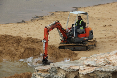 Ballarat Heritage Services
Photograph - Digital photographs, L.J. Gervasoni, Hopkins River Mouth blocked - channel digger, c2010 - 2017
Colour photograph of the blocked mouth of the Hopkins River being opened by a channel digger. hopkins river, mouth, point ritchie, bluehole, warrnambool, coast, coastal, beach, seascape, blocked, digger, opening mouth, mechanical opening -
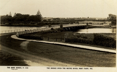
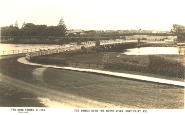 Port Fairy Historical Society Museum and Archives
Postcard, The Rose Series / The Rose Stereographs, The Bridge over Moyne River, Port Fairy Vic
Black and white Photograph of the bridge over the Moyne river with the Botanical Gardens on the left in the background and also some huts on Hughes Avenue in the backgroundThe Rose Series P. 1123 copyright- The Bridge over the Moyne River Port Fairy Vic.moyne bridge circa 1930, moyne river, bridge, river, botanical gardens -
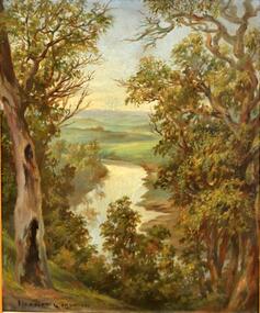 Kew Historical Society Inc
Painting, Herbert J Woodhouse, River Yarra Near Dights Falls, c.1892
Herbert James Woodhouse (1854-1937) was born in Essex and arrived in Australia with his family in 1857. A painter-lithographer like his father and three of his brothers, he was a prizewinner in the South Australian Society of Arts exhibition of 1885. He also received commendations in exhibitions at the Victorian Academy of Arts and the New South Wales Arts Society. At an exhibition of his paintings at Scott’s Hotel in Collins Street in 1892, the reviewer for Table Talk noted that the ‘artist paints almost solely in the open air, and his studies are generally carried out during the trips of the Victorian Sketching Club’. One of the paintings singled out for praise was: ‘A very effective river scene at Willsmere, aptly named A Midstream Mirror, ... a picture powerful in its effective reflection of sunlight in the river.’ Herbert Woodhouse died in Geelong in June 1937, aged 82, and was buried in the Eastern Cemetery. A number of his sketchbooks are held in the collection of the State Library of Victoria.Framed oil painting on board of the River Yarra at Studley Park, Kew, by Herbert James Woodhouse (1858-1937). The artist has framed the narrow painting with trees in the foreground and a view of the Yarra River and rolling hills in the background. Verso, written by artist: "River Yarra Near Dights Falls"australian art - 19th century, herbert james woodhouse (1854-1937), yarra river - studley park -
University of Melbourne, Burnley Campus Archives
Photograph - Sepia Print, 4. View of River Through Fence
Yarra River.Labelled, " View of River through fence."yarra river, mrs. jessep, alexander william jessep, principal, a.w. jessep -
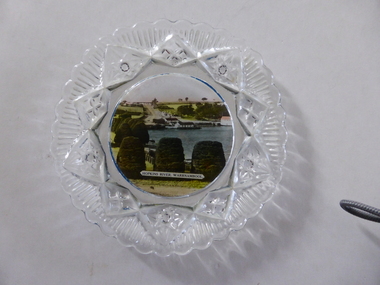 Warrnambool and District Historical Society Inc.
Platter, Transfer Hopkins River
This is a souvenir dish or small plate with an illustration of the Hopkins River in Warrnambool. Included in the illustration are the rowing shed, the boathouses and the lambertiana trees in the property of Lyndoch. The souvenir dish would have been sold to tourists visiting Warrnambool or Warrnambool residents in the 1920s and 30s. This type of souvenir was popular at the time in any tourist town or place in Australia. Tourism has been an important industry in Warrnambool since the late 19th century. This item is of interest as an example of the type of souvenir produced for tourists in the 1920s and 30s. It was both a useful and decorative item. It will be useful for display. This is a small glass souvenir dish. The centre of the dish features a colour illustration of the Hopkins River, Warrnambool (near its mouth). The glass around the illustration is heavily patterned and embossed. The bottom of the dish is dark blue. ‘Hopkins River Warrnambool’ tourism in warrnambool, warrnambool history -
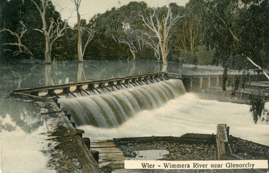 Stawell Historical Society Inc
Postcard, Wimmera River Weir at Glenorchy -- Postcard
Wimmera River Weir Glenorchy with letter written on card and 1d stamp.Coloured post card of a weir along a flooded river. Wier-Wimmera River near Glenorchy addressed to Mrs. G. Wood Hill View Stawell. Message from Oliver dated 8/6/10 plus stamp.water -
 Port Fairy Historical Society Museum and Archives
Postcard, The Rose Series / The Rose Stereographs, The Bridge over Moyne River, Port Fairy Vic
Black and white Photograph of the Moyne river road bridge with the botanical gardens in the left background and some huts built possibly on Hughes AvenueThe Rose Series P.1123 copyright.- The Bridge over the Moyne River Port Fairy Vic.moyne bridge, hughes avenue, gipps street, river, dunes, botanical gardens -
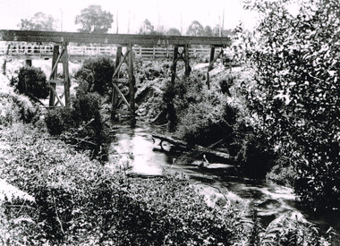 Otway Districts Historical Society
Photograph, Knox Collection, Railway Bridge over Gellibrand River, 1902
Railway bridge over the Gellibrand River, 1902. Note the people on the roadway bridge in the top left corner. B/W.colac; beech forest; gellibrand; railway; -
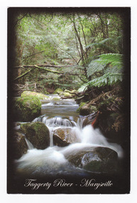 Marysville & District Historical Society
Postcard (item) - Colour postcard, Rosewood Photography, Taggerty River - Marysville, Pre 2009
A colour photograph of the Taggerty River at Marysville in Victoria.A colour photograph of the Taggerty River at Marysville in Victoria. This postcard was produced by Rosewood Photography as a souvenir of Marysville.The Cascading waters of Taggerty River The beautiful & scenic Taggerty River is a 10 minute drive from Marysville, Victoria./ Surrounded by tree ferns & mos covered rocks, the tranquil sounds of the flowing/ river are great place to visit while in Marysville. Photography & Design by/ Roswood Photography/ Mulgrave, Victoria/ [email protected]/ Tel:1300 769 922 Date Stamp 2004/ 6 PM SUNDAY/ Dear Norma & Rod/ All is beauty + peace here/ -the colours are simply/ beautiful every where./ I've done some pleasant/ walking + look forward/ to some more/ Frosty/ mornings perishing - but/ days lovely!!/ Take care - Love-/ Sar-jane A MR + MRS R McDONALD/ 24 PRINCETOWN RD/ MT WAVERLEY/ VIC 3149marysville, taggerty river, victoria, rosewood photography, postcard, souvenir -
 Lakes Entrance Historical Society
Postcard, Tambo River at Tambo Upper Victoria, 1/02/2024 12:00:00 AM
Black and white photograph of the cliffs on the Tambo River at Tambo Upper Victoria. Also two colour photographs of same cliff taken 1999 visit of Monkhouse family 6th to 24th February 1924 on backwaterways -
 Orbost & District Historical Society
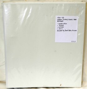
folder, Orbost Bridges - Snowy River Road Bridges, 1974 1976
This folder was compiled in October 2015 from documents, magazines. papers and photographs donated by David Jellie, engineer in charge 1974 - 1976. In early 1974, as an Engineer with the Country Roads Board, David came to Orbost as the Supervising Engineer for the construction of the new bridges which were part of an 8.4km Orbost bypass road design. This was a major project involving not only a new bridge over the Snowy River (including Lochiel Lagoon), but other bridges over Ashby’s Gulch and Watt’s Gulch. These new bridges were opened in November 1976 with the unveiling of a plaque on the eastern end of the $2.4M Snowy River Bridge. (ref. May Leatch)This item is a useful reference tool on the construction history of the Snowy River Road bridges.A white plastic folder - Orbost Bridges - Snowy River Road Bridges. it contains newspaper articles, booklets, photographs and documents relating to the construction of the Snowy River Road Bridge in 1974 -1976.on front cover - 1974 - 76 ORBOST / SNOWY RIVER ROAD BRIDGES * construction * photos * articles * plans Donated by David Jellie Oct 2015snowy-river-bridges jellie-david -
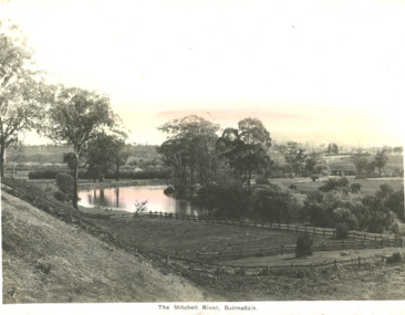 Lakes Entrance Historical Society
Postcard - Mitchell River Bairnsdale Victoria, 1920 c
One of the series of postcards used in the tourist industryPostcard of scene of Mitchell River with fences in the foreground and in the background bridge and Bairnsdale VictoriaThe Mitchell River Bairnsdalehouses, rivers, topography -
 Otway Districts Historical Society
Photograph, Gellibrand River railway bridge, 1901, 1901
Photograph, B/W, A4. Railway bridge over the Gellibrand River with people standing at the right-hand end, a railway water tank nearby on the left, and a tent underneath on the left.gellibrand, gellibrand river;railways; bridge; -
 Australian National Surfing Museum
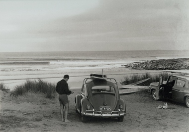
Photograph, Jack Eden, Kennett River, 1964
Black and white photograph taken by Jack Eden at Kennett River, Victoria, in 1964. Image is of a surfer standing next to a VW with surfboards on the roof. Another car and more boards on the ground also appear in the picture. In the background is a peeling wave with a surfer riding it. More surfers sit waiting. Jack Eden was a pioneer of Australian surfing and surf photography. His images capture something of arguably the halcyon days of Australian surfing. Rare image of surfing at remote Kennett Rover along the Great Ocean Road.Black and white photograph taken at Kennett River, Victoria, of a surfer standing next to a VW sedan with surfboards on the roof. Another car and more boards on the ground is to the right of the VW. In the background is a righthand, peeling wave with a surfer riding it.Titled: Australia Jack Eden, Kennett River, Victoriakennett river, surfboards, vw sedan, jack eden, great ocean road -
 Lakes Entrance Historical Society
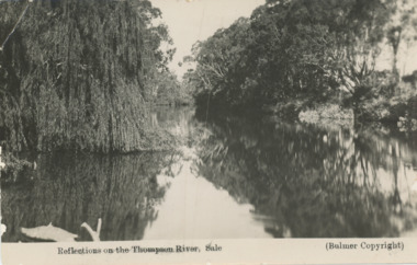
Postcard, Bulmer, Thomson River Sale, 1930 c
Message on back from Lois Langley of RAAF SaleBlack and white postcard showing a scene of Thomson River Sale VictoriaReflections on the Thomson River Saleboats and boating, waterways