Showing 124 items
matching rock formation
-
 Phillip Island and District Historical Society Inc.
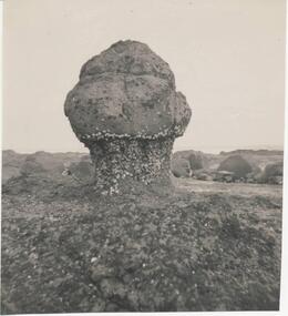
Photograph, Dr G Baker
... rock formation... Island local history photography rock formation black & white ...One of a collection of over 400 photographs in an album commenced in 1960 and presented to the Phillip Island & Westernport Historical Society by the Shire of Phillip IslandPhotograph of a natural bollard on the reef at Sunderland Bay, Phillip Islandlocal history, photography, rock formation, black & white photograph, coastline, sunderland bay, dr g baker, john jenner, bryant west -
 Phillip Island and District Historical Society Inc.
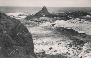
Photograph, Bryant West
... coastline - rock formation - pyramid rock... formation - pyramid rock coastline south coast pyramid rock john ...One of a collection of over 400 photographs in an album commenced in 1960 and presented to the Phillip Island & Westernport Historical Society by the Shire of Phillip IslandPhotograph of Pyramid Rock looking south from cliff toplocal history, photography, photographs, coastline - rock formation - pyramid rock, coastline, south coast, pyramid rock, john jenner, bryant west -
 Glenelg Shire Council Cultural Collection
Photograph - Photograph - Cape Bridgewater, 1956
... rock formation... rock formation seascape coastline south west coastline Back ...Black and white photo. Close up photograph of the rocky cliffs at Cape Bridgewater.Back: '56' in pencilcape bridgewater, rocks, rock formation, seascape, coastline, south west coastline -
Glenelg Shire Council Cultural Collection
Photograph - Photograph - Cape Bridgewater, n.d
... rock formation... Cliff Street Portland great-ocean-road Cape Bridgewater rock ...Black and white photo - of rough seas breaking on rocks at foot of cliffs, Cape Bridgewater. Two ladies standing on top of cliff, left of photoBack: 'Rough sea - Cape Bridgewater' - handwritten, black ink. '7' - pencilcape bridgewater, rock formation, cliffs, south west coastline, coastline -
Glenelg Shire Council Cultural Collection
Photograph - Photograph - Shelly Beach, Cape Bridgewater, M. E. Andrews, n.d
... rock formation... Beach beach photography seascape rock formation Back: 'Scenic ...Black and white photo of natural rock arch at Shelly Beach, Cape Bridgewater.Back: 'Scenic Arch Shelley Beach Cape Bridgewater' - handwritten in black ink Round purple stamp 'PRINTED BY M.E. ANDREWS PORTLAND'cape bridgewater, shelly beach, beach photography, seascape, rock formation -
Glenelg Shire Council Cultural Collection
Photograph - Photograph - Shelly Beach, Cape Bridgewater, n.d
... rock formation... Bridgewater Portland rock formation Back: 'Natural Arch, Bridgewater ...Black and white photo of natural rock arch at Shelly Beach. Mr. H.L. Vivian , dressed in a suit and with a walking stick, is standing beneath the arch.Back: 'Natural Arch, Bridgewater Bay Mr. H.L. Vivian in centre' - handwritten in black ink Round purple stamp 'PRINTED BY M.E. ANDREWS PORTLAND'shelly beach, cape bridgewater, portland, rock formation -
Glenelg Shire Council Cultural Collection
Photograph - Photograph - Cape Bridgewater, n.d
... rock formation... rock formation Back: 'Scene Cape Bridgewater' - handwritten ...Black and white photo. Waves breaking against base of rocky cliffs at Cape Bridgewater.Back: 'Scene Cape Bridgewater' - handwritten, black inkcape bridgewater, seascape, rock formation -
 Flagstaff Hill Maritime Museum and Village
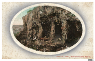
Postcard - Scenic, Warrnambool, Pillar Caves, near Warrnambool, 1902-1929
... rock formation... Caves rock formation with figures on it suggests ...The nine postcards in this set were donated together and date to the early 1900s. All but one postcard in this set shows images of Warrnambool, in the Western District of Victoria; the other has a London image. The postcards were all printed in Great Britain according to that country’s postal regulations. The fronts of all cards have titles printed in red. Most of the images on the cards are attributed to photographer Joseph Jordan and belong to the Jordan Series. The back of these cards has an outline for a postage stamp, a vertical dividing line and a heading on each side of the line to separate the Correspondence from the Address. Postcards or ‘correspondence cards’ appeared in Britain in 1894. They were plain cards with a space for the message on one side and an address on the other; regulations didn’t allow anything but the address to be written on the ‘address’ side. In 1902 the British regulations then allowed a picture to be printed on the front and the address on the back, so messages had to be written on the picture side. Soon, the regulations changed and the back was divided for a message and the address. Pliiar Caves, near Warrnambool – The formation at the front of the cave resembles the pillars of a porch, giving the cave its name. Local social media discussion locates the caves near Lake Gillear, east of Warrnambool. The area was popular with young lads as a place to explore and to go rabbiting. The caves in this area are home to colonies of bats and have been a source of bat feces or bat guano, which is an enriching additive to soil. The 19th century sailing ships in the Nitrogen or Guano trade collected large quantities of guano from caves and popular bird nesting locations to sell as a rich fertiliser, due to its high nitrogen and phosphorus properties. Joseph Jordan - Joseph Jordan was born in 1841 in Leicester England. When he was 16 he joined the 7th Queen's Own Hussars and was sent to India at the outbreak of the mutiny. He took part in the relief of Lucknow and remained in India for eleven years. It was during this time that he became interested in photography. He was posted to New Zealand and later came to Victoria, becoming a sergeant major of the Mounted Rifles. In the mid-1880s he came to the Western district where he was responsible for establishing units of the Mounted Rifles in various country towns such as Dunkeld, Mortlake, Panmure, Bushfield, Koroit etc. He resigned from the army in 1889 and set up a professional photography studio in Liebig Street, Warrnambool. He became very well known in the Western District for family photographs, official photographs of local councillors and groups as well as views of local scenery. In 1891 he photographed the wrecked barque ‘Fiji’ at ‘Wrecks Beach’ near Princetown. His business was taken over by his son Arthur around 1917. Joseph was a keen rifle shot and in 1924 he donated the "Jordan Shield" as a prize to the Victorian Rifle Association. He was made a "Life Honorary Member" of the Warrnambool Returned Soldiers League and in 1933 he was recognised as being the oldest living soldier in Victoria. Joseph died in 1935 aged 95.The image of the Pillar Caves rock formation with figures on it suggests that the location was a popular place to visit. The choice of subject for this postcard indicates the popularity of Warrnambool's natural environment as a tourist attraction at a time when ships called coastal traders brought passengers and cargo to the Port of Warrnambool from ports along Victoria's southwest coast. The presence of bats in local caves also connects the postcard to the 19th century Nitro Trade and Guano Trade, when bat guano was collected and sold for plant fertiliser around the world. Joseph Jordan is a significant figure in Warrnambool history as he helped to establish early units of the Mounted Rifles (G Company) in local towns during the late 1880's and later, photographed local scenes, groups and citizens of early Warrnambool.Postcard, one of nine, landscape orientation, coloured print within an oval border and mauve-toned shading. The cameo image shows figures on the high, grass-topped cliff, one between the likeness of pillars in the cave entry, and others walking on the rocks nearby. The background below is rough ground. There is no correspondence written on the card. The back has inscriptions and outlines for a postage stamp. Jordan Series, printed in Great Britain.Front, in red: “PILLAR CAVES, NEAR WARRNAMBOOL” Back in black: “Jordan Series” “POST CARD” “PRINTED IN GREAT BRITAIN” “For correspondence” “The Address only to be written here”flagstaff hill maritime museum, flagstaff hill maritime village, flagstaff hill maritime museum and village, maritime museum, warrnambool, great ocean road, warrnambool and district, warrnambool scenes, local scenes, views of warrnambool, joseph jordan, jordan series, jordan photography, postcard, souvenir, correspondence, cameo postcard, landscape, rock formation, pillar caves, pillars cave, lake gillear, rebbiting, bats, guano, nitro trade, fertilizers -
 Peterborough History Group
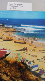
Photograph - Surf Carnival, Newfield Bay, Jocelyn Burt
... crown of thorns rock formation... crown of thorns rock formation Written on the back is Jocelyn ...Unusual choice of location by Port Campbell Surf club due to Port Campbell beach being too small. The Surf Carnival was held at Newfield Bay (possibly for two years running). Eyewitness accounts advise that one year the surf was so rough that the event was abandoned. This photograph appears to show calmer sea. In order to get the surf boats onto the beach a track was bulldozed over the sand dunes. Spectators cars were parked in the area which is now the airstrip, on the corner of the Port Campbell Peterborough Road and the Timboon Peterborough road.Town eventOriginal photograph of the surf carnival, taken from the west looking towards the east, with the Crown of thorns visible in the background. Surf boats are on the beach and umbrellas are visible. Occurred in the early 1970's.Written on the back is Jocelyn Burt, who is a photographer.newfield bay, surf lifesaving carnival, peterborough, jocelyn burt, crown of thorns rock formation -
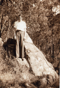
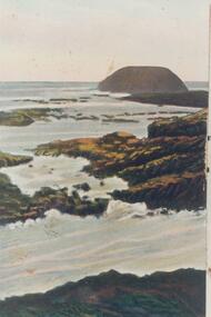 Phillip Island and District Historical Society Inc.
Photograph, Early 20th Century
... Coloured copy of a postcard showing the Nobbies with rock... the Nobbies with rock formation in the foreground. Photograph ...One of a collection of photographs donated by Bruce BennettColoured copy of a postcard showing the Nobbies with rock formation in the foreground.the nobbies phillip island, phillip island coastline, bruce bennett -
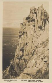 Phillip Island and District Historical Society Inc.
Photograph - Post Card, Early 1900's
... Sepia postcard of a rock formation at Cape Woolamai called... Woolamai, Phillip Island, Victoria" Sepia postcard of a rock ...One of a collection of 4 photographs donated by Y. Hancock.Sepia postcard of a rock formation at Cape Woolamai called The Watch Tower."The Rose Series P. 679" "The Watch Tower, Cape Woolamai, Phillip Island, Victoria"the watch tower, the watch tower cliffs, cape woolamai cliffs, the watch towes at cape woolamai, phillip island coastline, y hancock -
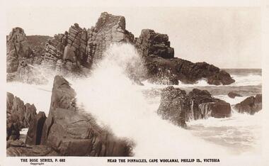
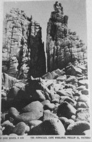 Phillip Island and District Historical Society Inc.
Photograph, The Pinnacles, Cape Woolamai
... Black & White Postcard. Rock formation known... Postcard. Rock formation known as The Pinnacles at Cape Woolamai ...Part of a collection of 'Rose & Valentine' series of Post Cards. Copied by John Jansson 1984Black & White Postcard. Rock formation known as The Pinnacles at Cape Woolamai.Rose Series P678. The Pinnacles, Cape Woolamai, Phillip Island, Victoria.local history, photography, photographs, postcards, phillip island, black & white postcard copy, the pinnacles, cape woolamai -
Tatura Irrigation & Wartime Camps Museum
Document, Geological Plan, Eildon Dam Site, 1945
... A series of maps illustrating rock formations etc... illustrating rock formations etc., locations, boundaries and plans ...To record details of geological aspects of EildonA series of maps illustrating rock formations etc., locations, boundaries and planswater/irrigation, documents, maps -
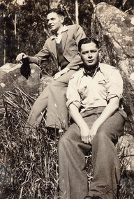 Mt Dandenong & District Historical Society Inc.
Photograph, Two men seated at The Rock, William Street, Kalorama. 1943, 1943
... Laurie ? and friend seated on rock formation in William... on rock formation in William Street, Kalorama in 1943. Two men ...Laurie ? and friend seated on rock formation in William Street, Kalorama in 1943.kalorama, william street -
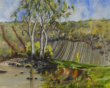 Brimbank City Council Art Collection
Painting, Organ Pipes, Keilor, 1977
... Oil on Canvas, oil painting of The organ Pipes (rock... of The organ Pipes (rock formation) in Keilor. Organ Pipes, Keilor ...One of a series of paintings by F. DischOil on Canvas, oil painting of The organ Pipes (rock formation) in Keilor. -
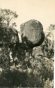 Stawell Historical Society Inc
Postcard, The Balanced Rock Wonderland in the Grampians -- Postcard
... on the edge of a rock formation.... of a round boulder balancing on the edge of a rock formation ...The Balanced Rock Wonderland The GrampiansBlack and white photograph of a round boulder balancing on the edge of a rock formation.The Balanced rock Wonderland.halls gap grampians -
 Phillip Island and District Historical Society Inc.
Photograph, The Pinnacles, Phillip Island, c 1926
... Sepia Postcard of Rock formations near the Pinnacles, Cape... phillip island sepia photograph ian reiher rock formations ...Sepia Postcard of Rock formations near the Pinnacles, Cape Woolamai, Phillip Island.The Rose Series P682. Near the Pinnacles, Cape Woolamai, Phillip Is., Victorialocal history, postcards, cape woolamai, phillip island, sepia photograph, ian reiher, rock formations, the pinnacles -
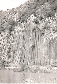
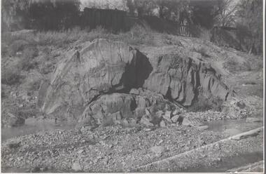 Bendigo Historical Society Inc.
Photograph - Napoleon Anticline, 1935
... Black and white photograph: rock formation, anticline... photograph: rock formation, anticline with an archlike shape ...In structural geology, an anticline is a type of fold that is an arch-like shape and has its oldest beds at its core, whereas a syncline is the inverse of an anticline. A typical anticline is convex up in which the hinge or crest is the location where the curvature is greatest, and the limbs are the sides of the fold that dip away from the hinge.Significant to mining history of Bendigo.Black and white photograph: rock formation, anticline with an archlike shape in centre of image. Written in pencil on back of photograph : 'Napoleon anticline Golden Square'.napoleon gold mine, anticline -
 Mt Dandenong & District Historical Society Inc.
Photograph, Laurie at The Rock on William Street Kalorama, April 1941, 1941
... View of man, Laurie ? standing on a rock formation... ? standing on a rock formation in William Street, Kalorama in April ...View of man, Laurie ? standing on a rock formation in William Street, Kalorama in April 1941.kalorama, william street -
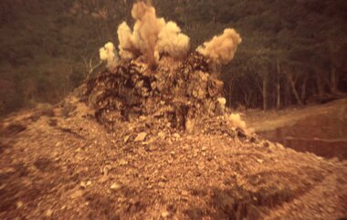 Stawell Historical Society Inc
Slide, Ian McCann, Explosive removal, 1965
... Colour Slide: Showing the explosive removal of a rock...: Showing the explosive removal of a rock formation during ...Construction of Lake BellfieldColour Slide: Showing the explosive removal of a rock formation during the Construction of what will be Lake Bellfield.grampians -
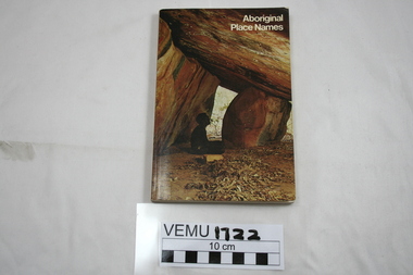 Emerald Museum & Nobelius Heritage Park
Book, Aboriginal Place Names, First published 1967, this reprint 1974
... seated under a rock formation with a sloping roof.... of an aboriginal man seated under a rock formation with a sloping roof ...Names and meanings came mostly from NSW and to a lesser extent from Western Australia, Victoria and Queensland. They throw light on the customs and life of the aborigines.Paperback book with a front cover of an aboriginal man seated under a rock formation with a sloping roof. -
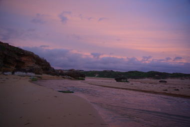 Victorian Interpretive Projects Inc.
Photograph - Colour, Clare Gervasoni, Mouth of the Hopkins River, Warrnambool, 2013, 22/12/2013
... . This area, also known as Blue Hole, features ciiffs, rock formations..., features ciiffs, rock formations and rock pools. Mouth ...The Hopkins River flows through WarrnamboolFive colour photographs of Warrnambool's Hopkins River. This area, also known as Blue Hole, features ciiffs, rock formations and rock pools. warrnambool, hopkins river, mouth, blue hole -
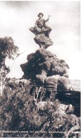 Halls Gap & Grampians Historical Society
Photograph - B/W
... Woman seated on peculiar corkscrew shaped rock formation... Grampians Ranges Woman seated on peculiar corkscrew shaped rock ...Coronation Chair, Mt. Victory, Grampians, written on front of photo.Woman seated on peculiar corkscrew shaped rock formation,trees with bushes at bottom,sky back ground.scenery, grampians ranges -
 Hume City Civic Collection
Photograph
... A black and white photograph of the unusual rock formation... A black and white photograph of the unusual rock formation known ...A black and white photograph of the unusual rock formation known as the Organ Pipes National Park in Diggers Rest.organ pipes national park, diggers rest, parks and reserves, national parks, evans, kevan, photographers, george evans collection -
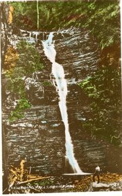 Stawell Historical Society Inc
Postcard, Silverband Falls in the Grampians -- Postcard
... of rock formation. A person is standing at the base of the falls.... water falls on layers of rock formation. A person is standing ...Silverband Falls No 21 The GrampiansColoured photograph of a very tall water falls on layers of rock formation. A person is standing at the base of the falls.Silverband Falls Grampians No 21halls gap grampians -
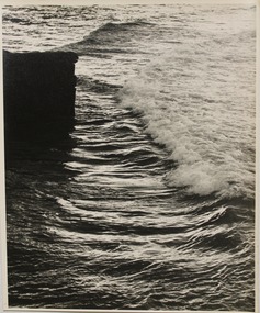 Glenelg Shire Council Cultural Collection
Photograph, Seascape, n.d
... formation on left. Wave has 'broken' & foam almost to rock...., with a squarish rock formation on left. Wave has 'broken' & foam almost ...Con Kroker Private CollectionBlack & white photo of the sea, with a squarish rock formation on left. Wave has 'broken' & foam almost to rock.Back: LAT 5D - pencil, very faintcon kroker, kroker, photography, seascape -
 Glenelg Shire Council Cultural Collection
Photograph, Seascape, n.d
... , possibly Discovery Bay. Rock formations & cliff with spinafix... of a long stretch of beach, possibly Discovery Bay. Rock formations ...Con Kroker Private CollectionBlack & white Photograph of a long stretch of beach, possibly Discovery Bay. Rock formations & cliff with spinafix and other grasses, in backgroundcon kroker, kroker, photography -
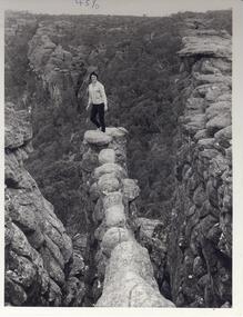 Halls Gap & Grampians Historical Society
Photograph - B/W
... . Large rock formations flank ledge on both sides. Woman... standing at end of narrow ,rocky ledge. Large rock formations flank ...Photo is of the 'Nerve Test' and is a tourism promotion photo taken by the Victorian Railways. Photo shows woman standing at end of narrow ,rocky ledge. Large rock formations flank ledge on both sides. Woman is wearing black pants and a cardigan.scenery, wonderland range -
University of Melbourne, Burnley Campus Archives
geological survey - Map, Maps of Geelong and Portarlington areas, 1963
... sedimentary and igneous rock formations and contours. B. Coloured... and igneous rock formations and contours. B. Coloured geological ...A. Coloured geological survey map of Geelong area: showing sedimentary and igneous rock formations and contours. B. Coloured geological survey map of Portarlington, Victoria. By Dept. Of Mines, Melbourne.geological survey, geelong, portarlington -
 Bendigo Historical Society Inc.
Document - VICTORIA HILL - ABRIDGED SIGNS FOR VICTORIA HILL
... Mine, Anticlinal Arch, Coloured rock formations marking... Legs Coloured rock formations Primitive tunnels Adit Engine ...Handwritten carbon copy of notes with typed copy of same, for signs on Victoria Hill. Signs mentioned are: Ballerstedt's First Open Cut,20 Head Crushing Battery, Victoria Quartz Mine, Victoria Quartz Foundations of Steel Poppet Legs, Coloured rock formations, Primitive tunnels, Adit, Engine Beds Lansell's Big 180 Mine, Anticlinal Arch, Coloured rock formations marking and patterns. Notes prepared by Albert Richardson.document, gold, victoria hill, victoria hill, abridged signs for victoria hill, ballerstedt's first open cut, 20 head crushing battery, victoria quartz mine, victoria quartz foundations of steel poppet legs, coloured rock formations, primitive tunnels, adit, engine beds lansell's big 180 mine, anticlinal arch, coloured rock formations marking and patterns