Showing 80 items matching " south ironbark"
-
 Eltham District Historical Society Inc
Photograph - Aerial Photograph, Landata, Eltham; Crown Allotment 15, Section 5, Parish of Nillumbik (Stokes Orchard Estate), Feb. 1979
Centred on present day Diosma Rd, Stokes Pl, Nyora Rd and Eucalyptus Rd Historic Aerial Imagery Source: Landata.vic.gov.au Aerial Photo Details: Project No :1716 Project : WESTERN PORT FORESHORES Run : 15 Frame : 91 Date : 02/1979 Film Type : B/W Camera : RC8 Flying Height : 5500 Scale : 10000 Film Number : 3286 GDA2020 : 37°42'47"S, 145°09'57"E MGA2020 : 338339, 5824447 (55) Melways : 22 C4 (ed. 42) A History of the Development of Crown Allotment 15, Section 5, Parish of Nillumbik – Stokes Orchard Crown Allotment 15, Section 5, Parish of Nillumbik (CA15) is a square allotment of 158 acres or approximately a quarter of a square mile. It lies just beyond the eastern end of Pitt Street, south of Nyora Road to the northern end of Eucalyptus Road and extends east from Eucalyptus Road to Reynolds Road. The topography of CA15 is generally steep, sloping up to a hill near the centre of the land, the ridgeline passing through the properties along the southern side of Diosma Road. Eucalyptus Road is a straight north-south road with its northern end at the north west corner of CA15. Until the end of the 1970s this road was an un-named Government Road and was largely not open to traffic. With residential development in the 1970s the road was constructed, and the council allocated the name obviously in recognition of the predominant species of the local bushland. CA15 was purchased from the Crown by George D’Arley Boursiquot, a prominent Melbourne printer, on 28th October 1852. On November 23, 1922, former Member for Gippsland and Melbourne Real Estate Agent, Hubert Patrick Keogh purchased the allotment then sold it March 13, 1925, to local farmer, Robert David Taylor, a former Shire of Eltham Councillor (1911-1920) and Shire President (1919). Taylor had extensive land holdings stretching west towards Bible Street and Main Road. The Taylor home was situated at the top of the hill in Bible Street at present day 82 Bible Street. At the time of Taylor’s purchase in 1925, CA15 was subdivided into 48 lots that could be described as small rural properties or large residential lots. A typical lot size was one hectare or 2.5 acres. The subdivision created two roads, Nyora Road, and Diosma Road, each following an irregular alignment between Eucalyptus and Reynolds Roads. However, the lots were not sold off separately nor were the roads constructed. The land effectively remained as one parcel for many further years. Robert David Taylor died November 30, 1934, and probate was granted to his son of the same name, Robert David Taylor of Bible Street, Salesman and William McLelland Vance Taylor of 73 Emmeline Street, Northcote, Clerk, with the transfer of the land into their names on July 8, 1935. Frank Stokes worked as a qualified accountant at Kennons leather factory in Burnley, while living at 1 Thomas Street, Mitcham. He suffered from migraines and wanted to return to working the land (he had previously worked on farms and orchards since coming to Australia from England in 1926, both in WA and Vic.). He first travelled to the district by train in July 1942 to find land with the intention to establish an orchard. By chance he met Arthur Bird of Bird Orchard (bounded by Pitt Street, Eucalyptus Road, and Wattle Grove) and they got talking over their common interest. Arthur put Frank up for the night and pointed out the land, 158 acres- part of the Taylor Estate- £900, Crown Allotment 15, Section 5, Parish of Nillumbik (CA15) somewhat diagonally opposite Bird Orchard. Stokes applied through the Riverina Agency to purchase the land who in turn applied for permission from Canberra to sell as there was a new government regulation introduced during the Second World War banning land sales except for immediate production. Stokes obtained a loan on his Mitcham house of £600 @ 5% and paid £450 deposit with quarterly payments of £15 spread over 5 years. Stokes was assisted and advised by Arthur Bird who farmed the neighbouring orchard. In early 1943 Stokes took possession and would catch the train out to Eltham on Fridays after work and began building a hut on the corner of Nyora Road and the Government Road (Eucalyptus Road) for shelter and to lock up tools. He established an orchard on the central western part of the land through the centre of which ran a natural waterway (part of the present-day linear park) and was able to pay a neighbour (Hawkins) to help with clearing and fencing 25 acres, and with a horse and single furrowed plough, planted approximately 2,500 fruit trees - cherries, peaches, plums, almonds, pears, apricots and lemons as well as a few apples and oranges; a massive task. Aerial photographs from the 1940s through to the 1990s clearly show the orchard with most of the larger CA15 site remaining as natural bushland. A huge problem was hares and rabbits eating all the new buds off the tiny trees. As well as laying poison he painted the trees with a mixture of cow manure and lime, often working by moonlight. Procurement of wire and wire netting was difficult because of the war but after much effort he obtained a permit from the Agricultural Department for supplies in March 1944. In February 1945 Stokes applied for a permit to build a “packing shed” as no house building was allowed. It was to be 33 feet x 21 feet and cost £312. It was constructed mostly from second-hand materials, which were hard to obtain, especially iron for roofing. Stokes finished work at Kennons on October 31, 1945, and in March 1946 he sold the family home at Mitcham for £1,230 plus £170 for furniture. On May 15, 1946, title to the CA15 property was issued to Frank Howard Alfred Stokes, Orchardist and Gladys Ethel Stokes, Married Woman, both of Pitt Street, Eltham. The family of five then moved into the very unfinished “packing shed” at Eltham, which was a struggle to weatherproof. Eventually rooms were divided off and lined with hessian bags and whitewashed. Their income was firewood (cut and sold), selling rockery stones and cut Sweet Bursaria. (It was discovered during the 1940s that Sweet Bursaria contained the sunscreen compound Aesculin. The RAAF utilised this compound from Sweet Bursaria during WW2 for pilots and gunners.) The orchard’s first fruit sale was a half-case of Le Vanq peaches in December 1947 for the price of 8 shillings. In 1956 plans for house were drawn and Glen Iris bricks purchased (1956 Olympic Rings variant). The building of the house commenced in 1957 - 12 feet of original packing shed was removed – and was completed in 1959. Water was connected from newly built pressure storage on the property at the end of 1959 and the electricity connection for the first time at 3pm on April 29, 1960. The house remains to present day (somewhat modified) at 1 Nyora Road, home to Nyora Studio Gallery. On occasions, spare remnants of the 1956 bricks have been known to be unearthed in gardens on the estate as they were utilised by Frank Stokes to fill in rabbit holes. On May 26, 1950, a parcel of land was compulsorily acquired by the Melbourne and Metropolitan Board of Works on the hilltop to establish an easement for a high-level service reservoir to augment Eltham’s water supply. The project also included pipe tracks for the necessary water mains. The reservoir has now been superseded by higher level water tanks east of Reynolds Road and its former site is now a public reserve. On November 27, 1964, the State Electricity Commission served notice to compulsorily acquire a further parcel through the eastern part of the land for a major electricity transmission line that augmented supply from the La Trobe Valley to Melbourne. The easement was registered February 11, 1966. The easement was widened July 18, 1969 for a second transmission line to be constructed. In 1971 Melbourne Metropolitan Planning Scheme amendments adopted Nyora Road as the boundary between a residential zone to the north and a rural zone to the south. This determined the future development of the land. In the mid-1970s the Shire of Eltham divided the orchard into numerous rate-able parcel lots, the 48 lots having been established in 1925 and the subsequent rates assessment proved unsustainable for Stokes. He commenced selling lots outside the boundary of the orchard, north of Diosma and South of Nyora. However shortly later the land between Nyora and Diosma Roads and west of the electricity easement was sold and subdivided into residential lots, a housing development by Macquarie Builders and marketed as the Stokes Orchard Estate. New streets were created, and most were named after trees, although one, Stokes Place, commemorates the former owners. The development was undertaken in two stages; Stage 1 (1975) encompassing Scarlet Ash Court, Ironbark Close and Peppermint Grove bounded by Nyora and Eucalyptus roads and Stage 2 (1978) encompassing Stokes Place, Orchard Way, The Crest and The Lookout bound by Nyora and Diosma roads. The developer, Macquarie Builders went bankrupt shortly after the release of Stage 2 leaving many purchasers to fend for themselves and arrange for their own independent builders. There were also difficulties with sewerage for the land immediately south of Diosma Road and so the conventional residential lots were abandoned in favour of larger lots. The development of Orchard Way, The Crest and The Lookout did not proceed as planned and the proposed lots were incorporated into five-acre parcels instead. These included a low-density group housing development by the Graves family and the award winning Choong House (1983) with Gordon Ford developed garden immediately next door situated on the ridge of the hill nestled amongst the original bush, Eucalypt trees and Sweet Bursaria. In 1994, Nillumbik Shire Council applied Significant Environment and Significant Landscape overlays upon the properties on the south side of Diosma Road to ensure protection of this natural bush garden environment. With the arrival of the sewer along Diosma Road in the 1990s, most of these five-acre parcels have since been subdivided multiple times. The Choong house presently sits on a 2.7-acre property, which in 2022 Nillumbik Council nominated for Cultural Significance Heritage protection and is considered potentially significant at State level. The Stokes family were also associated with the Eltham Christian Church. In the 1970s this church had met in temporary premises in Eltham. Lots of the original 1925 subdivision remained south of Nyora Road and a number of these lots were utilized for the Eltham Christian School, which was established by the Eltham Christian Church in 1981. The school operated on this site until 2000. The premises are now used by The Vine Baptist Church. By the mid-1980s the whole of CA15 had been developed for residential and school purposes, except for the sections north of Diosma Road and between the transmission lines and Reynolds Road. Sewerage issues had been resolved for the section north of Diosma Road and in 1987 it was in the process of being subdivided into residential lots. The development coincided with the discovery of colonies of the rare and endangered Eltham Copper Butterfly on the site. This resulted in a community and political campaign to save the butterfly habitat. With the co-operation of the land developer the subdivision was altered to create two bushland reserves in the critical butterfly habitat areas. In the late 1980s the State Government was investigating options for establishing a metropolitan ring road link between Diamond Creek and Ringwood. The chosen route was adjacent to Reynolds Road and so this created a freeze on development of CA15 between Reynolds Road and the electricity easement. The ring road proposal was eventually abandoned, and this part of the land was subdivided into low density residential lots. Diosma Road has been discontinued at the electricity easement and the eastern part incorporated into View Mount Court with access from Reynolds Road. The whole of CA15 has now been developed for residential or associated purposes, ranging from conventional density to quite low density south of Nyora Road. Some remnants of the orchard remain, a few cherry trees on the Graves property and a lone apple tree in Stokes Place. The butterfly reserves comprise significant areas of remnant bushland. Linear reserves through the estate link with central Eltham via the Woodridge linear reserve and with Research along the electricity easement. CA15 as it exists today has a complicated history of rural use, Government acquisition, urban development, and community action. References: • “Stokes Orchard, an incomplete history”; Russell Yeoman with Doug Orford • Correspondence, Beryl Bradbury (nee Stokes) • Aerial Photographs, 1931-1991, Landata (landata.vic.gov.au) • Certificate of Title, Vol. 4930 Fol. 985900 • Plan Number LP 10859 aerial photo, diosma road, eltham copper butterfly, eucalyptus road, ironbark close, nyora road, peppermint grove, peter & elizabeth pidgeon collection, power transmission lines, reynolds road, scarlet ash court, stokes orchard estate, stokes place, woodridge estate, frank stokes -
 Eltham District Historical Society Inc
Photograph - Aerial Photograph, Landata, Eltham; Crown Allotment 15, Section 5, Parish of Nillumbik (Stokes Orchard Estate), Jan. 1984
Centred on present day Diosma Rd, Stokes Pl, Nyora Rd and Eucalyptus Rd Historic Aerial Imagery Source: Landata.vic.gov.au Aerial Photo Details: Project No :1716 Project : WESTERN PORT FORESHORES Run : 15 Frame : 70 Date : 01/1984 Film Type : B/W Camera : RC8 Flying Height : 5300 Scale : 10000 Film Number : 3833 GDA2020 : 37°42'38"S, 145°10'09"E MGA2020 : 338612, 5824719 (55) Melways : 22 D4 (ed. 42) A History of the Development of Crown Allotment 15, Section 5, Parish of Nillumbik – Stokes Orchard Crown Allotment 15, Section 5, Parish of Nillumbik (CA15) is a square allotment of 158 acres or approximately a quarter of a square mile. It lies just beyond the eastern end of Pitt Street, south of Nyora Road to the northern end of Eucalyptus Road and extends east from Eucalyptus Road to Reynolds Road. The topography of CA15 is generally steep, sloping up to a hill near the centre of the land, the ridgeline passing through the properties along the southern side of Diosma Road. Eucalyptus Road is a straight north-south road with its northern end at the north west corner of CA15. Until the end of the 1970s this road was an un-named Government Road and was largely not open to traffic. With residential development in the 1970s the road was constructed, and the council allocated the name obviously in recognition of the predominant species of the local bushland. CA15 was purchased from the Crown by George D’Arley Boursiquot, a prominent Melbourne printer, on 28th October 1852. On November 23, 1922, former Member for Gippsland and Melbourne Real Estate Agent, Hubert Patrick Keogh purchased the allotment then sold it March 13, 1925, to local farmer, Robert David Taylor, a former Shire of Eltham Councillor (1911-1920) and Shire President (1919). Taylor had extensive land holdings stretching west towards Bible Street and Main Road. The Taylor home was situated at the top of the hill in Bible Street at present day 82 Bible Street. At the time of Taylor’s purchase in 1925, CA15 was subdivided into 48 lots that could be described as small rural properties or large residential lots. A typical lot size was one hectare or 2.5 acres. The subdivision created two roads, Nyora Road, and Diosma Road, each following an irregular alignment between Eucalyptus and Reynolds Roads. However, the lots were not sold off separately nor were the roads constructed. The land effectively remained as one parcel for many further years. Robert David Taylor died November 30, 1934, and probate was granted to his son of the same name, Robert David Taylor of Bible Street, Salesman and William McLelland Vance Taylor of 73 Emmeline Street, Northcote, Clerk, with the transfer of the land into their names on July 8, 1935. Frank Stokes worked as a qualified accountant at Kennons leather factory in Burnley, while living at 1 Thomas Street, Mitcham. He suffered from migraines and wanted to return to working the land (he had previously worked on farms and orchards since coming to Australia from England in 1926, both in WA and Vic.). He first travelled to the district by train in July 1942 to find land with the intention to establish an orchard. By chance he met Arthur Bird of Bird Orchard (bounded by Pitt Street, Eucalyptus Road, and Wattle Grove) and they got talking over their common interest. Arthur put Frank up for the night and pointed out the land, 158 acres- part of the Taylor Estate- £900, Crown Allotment 15, Section 5, Parish of Nillumbik (CA15) somewhat diagonally opposite Bird Orchard. Stokes applied through the Riverina Agency to purchase the land who in turn applied for permission from Canberra to sell as there was a new government regulation introduced during the Second World War banning land sales except for immediate production. Stokes obtained a loan on his Mitcham house of £600 @ 5% and paid £450 deposit with quarterly payments of £15 spread over 5 years. Stokes was assisted and advised by Arthur Bird who farmed the neighbouring orchard. In early 1943 Stokes took possession and would catch the train out to Eltham on Fridays after work and began building a hut on the corner of Nyora Road and the Government Road (Eucalyptus Road) for shelter and to lock up tools. He established an orchard on the central western part of the land through the centre of which ran a natural waterway (part of the present-day linear park) and was able to pay a neighbour (Hawkins) to help with clearing and fencing 25 acres, and with a horse and single furrowed plough, planted approximately 2,500 fruit trees - cherries, peaches, plums, almonds, pears, apricots and lemons as well as a few apples and oranges; a massive task. Aerial photographs from the 1940s through to the 1990s clearly show the orchard with most of the larger CA15 site remaining as natural bushland. A huge problem was hares and rabbits eating all the new buds off the tiny trees. As well as laying poison he painted the trees with a mixture of cow manure and lime, often working by moonlight. Procurement of wire and wire netting was difficult because of the war but after much effort he obtained a permit from the Agricultural Department for supplies in March 1944. In February 1945 Stokes applied for a permit to build a “packing shed” as no house building was allowed. It was to be 33 feet x 21 feet and cost £312. It was constructed mostly from second-hand materials, which were hard to obtain, especially iron for roofing. Stokes finished work at Kennons on October 31, 1945, and in March 1946 he sold the family home at Mitcham for £1,230 plus £170 for furniture. On May 15, 1946, title to the CA15 property was issued to Frank Howard Alfred Stokes, Orchardist and Gladys Ethel Stokes, Married Woman, both of Pitt Street, Eltham. The family of five then moved into the very unfinished “packing shed” at Eltham, which was a struggle to weatherproof. Eventually rooms were divided off and lined with hessian bags and whitewashed. Their income was firewood (cut and sold), selling rockery stones and cut Sweet Bursaria. (It was discovered during the 1940s that Sweet Bursaria contained the sunscreen compound Aesculin. The RAAF utilised this compound from Sweet Bursaria during WW2 for pilots and gunners.) The orchard’s first fruit sale was a half-case of Le Vanq peaches in December 1947 for the price of 8 shillings. In 1956 plans for house were drawn and Glen Iris bricks purchased (1956 Olympic Rings variant). The building of the house commenced in 1957 - 12 feet of original packing shed was removed – and was completed in 1959. Water was connected from newly built pressure storage on the property at the end of 1959 and the electricity connection for the first time at 3pm on April 29, 1960. The house remains to present day (somewhat modified) at 1 Nyora Road, home to Nyora Studio Gallery. On occasions, spare remnants of the 1956 bricks have been known to be unearthed in gardens on the estate as they were utilised by Frank Stokes to fill in rabbit holes. On May 26, 1950, a parcel of land was compulsorily acquired by the Melbourne and Metropolitan Board of Works on the hilltop to establish an easement for a high-level service reservoir to augment Eltham’s water supply. The project also included pipe tracks for the necessary water mains. The reservoir has now been superseded by higher level water tanks east of Reynolds Road and its former site is now a public reserve. On November 27, 1964, the State Electricity Commission served notice to compulsorily acquire a further parcel through the eastern part of the land for a major electricity transmission line that augmented supply from the La Trobe Valley to Melbourne. The easement was registered February 11, 1966. The easement was widened July 18, 1969 for a second transmission line to be constructed. In 1971 Melbourne Metropolitan Planning Scheme amendments adopted Nyora Road as the boundary between a residential zone to the north and a rural zone to the south. This determined the future development of the land. In the mid-1970s the Shire of Eltham divided the orchard into numerous rate-able parcel lots, the 48 lots having been established in 1925 and the subsequent rates assessment proved unsustainable for Stokes. He commenced selling lots outside the boundary of the orchard, north of Diosma and South of Nyora. However shortly later the land between Nyora and Diosma Roads and west of the electricity easement was sold and subdivided into residential lots, a housing development by Macquarie Builders and marketed as the Stokes Orchard Estate. New streets were created, and most were named after trees, although one, Stokes Place, commemorates the former owners. The development was undertaken in two stages; Stage 1 (1975) encompassing Scarlet Ash Court, Ironbark Close and Peppermint Grove bounded by Nyora and Eucalyptus roads and Stage 2 (1978) encompassing Stokes Place, Orchard Way, The Crest and The Lookout bound by Nyora and Diosma roads. The developer, Macquarie Builders went bankrupt shortly after the release of Stage 2 leaving many purchasers to fend for themselves and arrange for their own independent builders. There were also difficulties with sewerage for the land immediately south of Diosma Road and so the conventional residential lots were abandoned in favour of larger lots. The development of Orchard Way, The Crest and The Lookout did not proceed as planned and the proposed lots were incorporated into five-acre parcels instead. These included a low-density group housing development by the Graves family and the award winning Choong House (1983) with Gordon Ford developed garden immediately next door situated on the ridge of the hill nestled amongst the original bush, Eucalypt trees and Sweet Bursaria. In 1994, Nillumbik Shire Council applied Significant Environment and Significant Landscape overlays upon the properties on the south side of Diosma Road to ensure protection of this natural bush garden environment. With the arrival of the sewer along Diosma Road in the 1990s, most of these five-acre parcels have since been subdivided multiple times. The Choong house presently sits on a 2.7-acre property, which in 2022 Nillumbik Council nominated for Cultural Significance Heritage protection and is considered potentially significant at State level. The Stokes family were also associated with the Eltham Christian Church. In the 1970s this church had met in temporary premises in Eltham. Lots of the original 1925 subdivision remained south of Nyora Road and a number of these lots were utilized for the Eltham Christian School, which was established by the Eltham Christian Church in 1981. The school operated on this site until 2000. The premises are now used by The Vine Baptist Church. By the mid-1980s the whole of CA15 had been developed for residential and school purposes, except for the sections north of Diosma Road and between the transmission lines and Reynolds Road. Sewerage issues had been resolved for the section north of Diosma Road and in 1987 it was in the process of being subdivided into residential lots. The development coincided with the discovery of colonies of the rare and endangered Eltham Copper Butterfly on the site. This resulted in a community and political campaign to save the butterfly habitat. With the co-operation of the land developer the subdivision was altered to create two bushland reserves in the critical butterfly habitat areas. In the late 1980s the State Government was investigating options for establishing a metropolitan ring road link between Diamond Creek and Ringwood. The chosen route was adjacent to Reynolds Road and so this created a freeze on development of CA15 between Reynolds Road and the electricity easement. The ring road proposal was eventually abandoned, and this part of the land was subdivided into low density residential lots. Diosma Road has been discontinued at the electricity easement and the eastern part incorporated into View Mount Court with access from Reynolds Road. The whole of CA15 has now been developed for residential or associated purposes, ranging from conventional density to quite low density south of Nyora Road. Some remnants of the orchard remain, a few cherry trees on the Graves property and a lone apple tree in Stokes Place. The butterfly reserves comprise significant areas of remnant bushland. Linear reserves through the estate link with central Eltham via the Woodridge linear reserve and with Research along the electricity easement. CA15 as it exists today has a complicated history of rural use, Government acquisition, urban development, and community action. References: • “Stokes Orchard, an incomplete history”; Russell Yeoman with Doug Orford • Correspondence, Beryl Bradbury (nee Stokes) • Aerial Photographs, 1931-1991, Landata (landata.vic.gov.au) • Certificate of Title, Vol. 4930 Fol. 985900 • Plan Number LP 10859 aerial photo, diosma road, eltham copper butterfly, eucalyptus road, ironbark close, nyora road, peppermint grove, peter & elizabeth pidgeon collection, power transmission lines, reynolds road, scarlet ash court, stokes orchard estate, stokes place, woodridge estate, frank stokes -
 Eltham District Historical Society Inc
Photograph - Aerial Photograph, Landata, Eltham; Crown Allotment 15, Section 5, Parish of Nillumbik (Stokes Orchard Estate), Mar. 1987
Centred on present day Diosma Rd, Stokes Pl, Nyora Rd and Eucalyptus Rd Historic Aerial Imagery Source: Landata.vic.gov.au Aerial Photo Details: Project No :1716 Project : WESTERN PORT FORESHORES Run : 15 Frame : 108 Date : 03/1987 Film Type : B/W Camera : RC10 Flying Height : 5600 Scale : 10000 Film Number : 4102 GDA2020 : 37°43'00"S, 145°10'13"E MGA2020 : 338725, 5824036 (55) Melways : 22 D5 (ed. 42)719 (55) Melways : 22 D4 (ed. 42) A History of the Development of Crown Allotment 15, Section 5, Parish of Nillumbik – Stokes Orchard Crown Allotment 15, Section 5, Parish of Nillumbik (CA15) is a square allotment of 158 acres or approximately a quarter of a square mile. It lies just beyond the eastern end of Pitt Street, south of Nyora Road to the northern end of Eucalyptus Road and extends east from Eucalyptus Road to Reynolds Road. The topography of CA15 is generally steep, sloping up to a hill near the centre of the land, the ridgeline passing through the properties along the southern side of Diosma Road. Eucalyptus Road is a straight north-south road with its northern end at the north west corner of CA15. Until the end of the 1970s this road was an un-named Government Road and was largely not open to traffic. With residential development in the 1970s the road was constructed, and the council allocated the name obviously in recognition of the predominant species of the local bushland. CA15 was purchased from the Crown by George D’Arley Boursiquot, a prominent Melbourne printer, on 28th October 1852. On November 23, 1922, former Member for Gippsland and Melbourne Real Estate Agent, Hubert Patrick Keogh purchased the allotment then sold it March 13, 1925, to local farmer, Robert David Taylor, a former Shire of Eltham Councillor (1911-1920) and Shire President (1919). Taylor had extensive land holdings stretching west towards Bible Street and Main Road. The Taylor home was situated at the top of the hill in Bible Street at present day 82 Bible Street. At the time of Taylor’s purchase in 1925, CA15 was subdivided into 48 lots that could be described as small rural properties or large residential lots. A typical lot size was one hectare or 2.5 acres. The subdivision created two roads, Nyora Road, and Diosma Road, each following an irregular alignment between Eucalyptus and Reynolds Roads. However, the lots were not sold off separately nor were the roads constructed. The land effectively remained as one parcel for many further years. Robert David Taylor died November 30, 1934, and probate was granted to his son of the same name, Robert David Taylor of Bible Street, Salesman and William McLelland Vance Taylor of 73 Emmeline Street, Northcote, Clerk, with the transfer of the land into their names on July 8, 1935. Frank Stokes worked as a qualified accountant at Kennons leather factory in Burnley, while living at 1 Thomas Street, Mitcham. He suffered from migraines and wanted to return to working the land (he had previously worked on farms and orchards since coming to Australia from England in 1926, both in WA and Vic.). He first travelled to the district by train in July 1942 to find land with the intention to establish an orchard. By chance he met Arthur Bird of Bird Orchard (bounded by Pitt Street, Eucalyptus Road, and Wattle Grove) and they got talking over their common interest. Arthur put Frank up for the night and pointed out the land, 158 acres- part of the Taylor Estate- £900, Crown Allotment 15, Section 5, Parish of Nillumbik (CA15) somewhat diagonally opposite Bird Orchard. Stokes applied through the Riverina Agency to purchase the land who in turn applied for permission from Canberra to sell as there was a new government regulation introduced during the Second World War banning land sales except for immediate production. Stokes obtained a loan on his Mitcham house of £600 @ 5% and paid £450 deposit with quarterly payments of £15 spread over 5 years. Stokes was assisted and advised by Arthur Bird who farmed the neighbouring orchard. In early 1943 Stokes took possession and would catch the train out to Eltham on Fridays after work and began building a hut on the corner of Nyora Road and the Government Road (Eucalyptus Road) for shelter and to lock up tools. He established an orchard on the central western part of the land through the centre of which ran a natural waterway (part of the present-day linear park) and was able to pay a neighbour (Hawkins) to help with clearing and fencing 25 acres, and with a horse and single furrowed plough, planted approximately 2,500 fruit trees - cherries, peaches, plums, almonds, pears, apricots and lemons as well as a few apples and oranges; a massive task. Aerial photographs from the 1940s through to the 1990s clearly show the orchard with most of the larger CA15 site remaining as natural bushland. A huge problem was hares and rabbits eating all the new buds off the tiny trees. As well as laying poison he painted the trees with a mixture of cow manure and lime, often working by moonlight. Procurement of wire and wire netting was difficult because of the war but after much effort he obtained a permit from the Agricultural Department for supplies in March 1944. In February 1945 Stokes applied for a permit to build a “packing shed” as no house building was allowed. It was to be 33 feet x 21 feet and cost £312. It was constructed mostly from second-hand materials, which were hard to obtain, especially iron for roofing. Stokes finished work at Kennons on October 31, 1945, and in March 1946 he sold the family home at Mitcham for £1,230 plus £170 for furniture. On May 15, 1946, title to the CA15 property was issued to Frank Howard Alfred Stokes, Orchardist and Gladys Ethel Stokes, Married Woman, both of Pitt Street, Eltham. The family of five then moved into the very unfinished “packing shed” at Eltham, which was a struggle to weatherproof. Eventually rooms were divided off and lined with hessian bags and whitewashed. Their income was firewood (cut and sold), selling rockery stones and cut Sweet Bursaria. (It was discovered during the 1940s that Sweet Bursaria contained the sunscreen compound Aesculin. The RAAF utilised this compound from Sweet Bursaria during WW2 for pilots and gunners.) The orchard’s first fruit sale was a half-case of Le Vanq peaches in December 1947 for the price of 8 shillings. In 1956 plans for house were drawn and Glen Iris bricks purchased (1956 Olympic Rings variant). The building of the house commenced in 1957 - 12 feet of original packing shed was removed – and was completed in 1959. Water was connected from newly built pressure storage on the property at the end of 1959 and the electricity connection for the first time at 3pm on April 29, 1960. The house remains to present day (somewhat modified) at 1 Nyora Road, home to Nyora Studio Gallery. On occasions, spare remnants of the 1956 bricks have been known to be unearthed in gardens on the estate as they were utilised by Frank Stokes to fill in rabbit holes. On May 26, 1950, a parcel of land was compulsorily acquired by the Melbourne and Metropolitan Board of Works on the hilltop to establish an easement for a high-level service reservoir to augment Eltham’s water supply. The project also included pipe tracks for the necessary water mains. The reservoir has now been superseded by higher level water tanks east of Reynolds Road and its former site is now a public reserve. On November 27, 1964, the State Electricity Commission served notice to compulsorily acquire a further parcel through the eastern part of the land for a major electricity transmission line that augmented supply from the La Trobe Valley to Melbourne. The easement was registered February 11, 1966. The easement was widened July 18, 1969 for a second transmission line to be constructed. In 1971 Melbourne Metropolitan Planning Scheme amendments adopted Nyora Road as the boundary between a residential zone to the north and a rural zone to the south. This determined the future development of the land. In the mid-1970s the Shire of Eltham divided the orchard into numerous rate-able parcel lots, the 48 lots having been established in 1925 and the subsequent rates assessment proved unsustainable for Stokes. He commenced selling lots outside the boundary of the orchard, north of Diosma and South of Nyora. However shortly later the land between Nyora and Diosma Roads and west of the electricity easement was sold and subdivided into residential lots, a housing development by Macquarie Builders and marketed as the Stokes Orchard Estate. New streets were created, and most were named after trees, although one, Stokes Place, commemorates the former owners. The development was undertaken in two stages; Stage 1 (1975) encompassing Scarlet Ash Court, Ironbark Close and Peppermint Grove bounded by Nyora and Eucalyptus roads and Stage 2 (1978) encompassing Stokes Place, Orchard Way, The Crest and The Lookout bound by Nyora and Diosma roads. The developer, Macquarie Builders went bankrupt shortly after the release of Stage 2 leaving many purchasers to fend for themselves and arrange for their own independent builders. There were also difficulties with sewerage for the land immediately south of Diosma Road and so the conventional residential lots were abandoned in favour of larger lots. The development of Orchard Way, The Crest and The Lookout did not proceed as planned and the proposed lots were incorporated into five-acre parcels instead. These included a low-density group housing development by the Graves family and the award winning Choong House (1983) with Gordon Ford developed garden immediately next door situated on the ridge of the hill nestled amongst the original bush, Eucalypt trees and Sweet Bursaria. In 1994, Nillumbik Shire Council applied Significant Environment and Significant Landscape overlays upon the properties on the south side of Diosma Road to ensure protection of this natural bush garden environment. With the arrival of the sewer along Diosma Road in the 1990s, most of these five-acre parcels have since been subdivided multiple times. The Choong house presently sits on a 2.7-acre property, which in 2022 Nillumbik Council nominated for Cultural Significance Heritage protection and is considered potentially significant at State level. The Stokes family were also associated with the Eltham Christian Church. In the 1970s this church had met in temporary premises in Eltham. Lots of the original 1925 subdivision remained south of Nyora Road and a number of these lots were utilized for the Eltham Christian School, which was established by the Eltham Christian Church in 1981. The school operated on this site until 2000. The premises are now used by The Vine Baptist Church. By the mid-1980s the whole of CA15 had been developed for residential and school purposes, except for the sections north of Diosma Road and between the transmission lines and Reynolds Road. Sewerage issues had been resolved for the section north of Diosma Road and in 1987 it was in the process of being subdivided into residential lots. The development coincided with the discovery of colonies of the rare and endangered Eltham Copper Butterfly on the site. This resulted in a community and political campaign to save the butterfly habitat. With the co-operation of the land developer the subdivision was altered to create two bushland reserves in the critical butterfly habitat areas. In the late 1980s the State Government was investigating options for establishing a metropolitan ring road link between Diamond Creek and Ringwood. The chosen route was adjacent to Reynolds Road and so this created a freeze on development of CA15 between Reynolds Road and the electricity easement. The ring road proposal was eventually abandoned, and this part of the land was subdivided into low density residential lots. Diosma Road has been discontinued at the electricity easement and the eastern part incorporated into View Mount Court with access from Reynolds Road. The whole of CA15 has now been developed for residential or associated purposes, ranging from conventional density to quite low density south of Nyora Road. Some remnants of the orchard remain, a few cherry trees on the Graves property and a lone apple tree in Stokes Place. The butterfly reserves comprise significant areas of remnant bushland. Linear reserves through the estate link with central Eltham via the Woodridge linear reserve and with Research along the electricity easement. CA15 as it exists today has a complicated history of rural use, Government acquisition, urban development, and community action. References: • “Stokes Orchard, an incomplete history”; Russell Yeoman with Doug Orford • Correspondence, Beryl Bradbury (nee Stokes) • Aerial Photographs, 1931-1991, Landata (landata.vic.gov.au) • Certificate of Title, Vol. 4930 Fol. 985900 • Plan Number LP 10859 aerial photo, diosma road, eltham copper butterfly, eucalyptus road, ironbark close, nyora road, peppermint grove, peter & elizabeth pidgeon collection, power transmission lines, reynolds road, scarlet ash court, stokes orchard estate, stokes place, woodridge estate, frank stokes -
 Eltham District Historical Society Inc
Photograph - Aerial Photograph, Landata, Eltham; Crown Allotment 15, Section 5, Parish of Nillumbik (Stokes Orchard Estate), Sep. 1991
Centred on present day Diosma Rd, Stokes Pl, Nyora Rd and Eucalyptus Rd Historic Aerial Imagery Source: Landata.vic.gov.au Aerial Photo Details: Project No :2072 Project : MELBOURNE PROJECT Run : 13 Frame : 119 Date : 09/1991 Film Type : COL Camera : RC10 Flying Height : 8300 Scale : 15000 Film Number : 4419 GDA2020 : 37°43'07"S, 145°09'35"E MGA2020 : 337812, 5823811 (55) Melways : 22 B6 (ed. 42) A History of the Development of Crown Allotment 15, Section 5, Parish of Nillumbik – Stokes Orchard Crown Allotment 15, Section 5, Parish of Nillumbik (CA15) is a square allotment of 158 acres or approximately a quarter of a square mile. It lies just beyond the eastern end of Pitt Street, south of Nyora Road to the northern end of Eucalyptus Road and extends east from Eucalyptus Road to Reynolds Road. The topography of CA15 is generally steep, sloping up to a hill near the centre of the land, the ridgeline passing through the properties along the southern side of Diosma Road. Eucalyptus Road is a straight north-south road with its northern end at the north west corner of CA15. Until the end of the 1970s this road was an un-named Government Road and was largely not open to traffic. With residential development in the 1970s the road was constructed, and the council allocated the name obviously in recognition of the predominant species of the local bushland. CA15 was purchased from the Crown by George D’Arley Boursiquot, a prominent Melbourne printer, on 28th October 1852. On November 23, 1922, former Member for Gippsland and Melbourne Real Estate Agent, Hubert Patrick Keogh purchased the allotment then sold it March 13, 1925, to local farmer, Robert David Taylor, a former Shire of Eltham Councillor (1911-1920) and Shire President (1919). Taylor had extensive land holdings stretching west towards Bible Street and Main Road. The Taylor home was situated at the top of the hill in Bible Street at present day 82 Bible Street. At the time of Taylor’s purchase in 1925, CA15 was subdivided into 48 lots that could be described as small rural properties or large residential lots. A typical lot size was one hectare or 2.5 acres. The subdivision created two roads, Nyora Road, and Diosma Road, each following an irregular alignment between Eucalyptus and Reynolds Roads. However, the lots were not sold off separately nor were the roads constructed. The land effectively remained as one parcel for many further years. Robert David Taylor died November 30, 1934, and probate was granted to his son of the same name, Robert David Taylor of Bible Street, Salesman and William McLelland Vance Taylor of 73 Emmeline Street, Northcote, Clerk, with the transfer of the land into their names on July 8, 1935. Frank Stokes worked as a qualified accountant at Kennons leather factory in Burnley, while living at 1 Thomas Street, Mitcham. He suffered from migraines and wanted to return to working the land (he had previously worked on farms and orchards since coming to Australia from England in 1926, both in WA and Vic.). He first travelled to the district by train in July 1942 to find land with the intention to establish an orchard. By chance he met Arthur Bird of Bird Orchard (bounded by Pitt Street, Eucalyptus Road, and Wattle Grove) and they got talking over their common interest. Arthur put Frank up for the night and pointed out the land, 158 acres- part of the Taylor Estate- £900, Crown Allotment 15, Section 5, Parish of Nillumbik (CA15) somewhat diagonally opposite Bird Orchard. Stokes applied through the Riverina Agency to purchase the land who in turn applied for permission from Canberra to sell as there was a new government regulation introduced during the Second World War banning land sales except for immediate production. Stokes obtained a loan on his Mitcham house of £600 @ 5% and paid £450 deposit with quarterly payments of £15 spread over 5 years. Stokes was assisted and advised by Arthur Bird who farmed the neighbouring orchard. In early 1943 Stokes took possession and would catch the train out to Eltham on Fridays after work and began building a hut on the corner of Nyora Road and the Government Road (Eucalyptus Road) for shelter and to lock up tools. He established an orchard on the central western part of the land through the centre of which ran a natural waterway (part of the present-day linear park) and was able to pay a neighbour (Hawkins) to help with clearing and fencing 25 acres, and with a horse and single furrowed plough, planted approximately 2,500 fruit trees - cherries, peaches, plums, almonds, pears, apricots and lemons as well as a few apples and oranges; a massive task. Aerial photographs from the 1940s through to the 1990s clearly show the orchard with most of the larger CA15 site remaining as natural bushland. A huge problem was hares and rabbits eating all the new buds off the tiny trees. As well as laying poison he painted the trees with a mixture of cow manure and lime, often working by moonlight. Procurement of wire and wire netting was difficult because of the war but after much effort he obtained a permit from the Agricultural Department for supplies in March 1944. In February 1945 Stokes applied for a permit to build a “packing shed” as no house building was allowed. It was to be 33 feet x 21 feet and cost £312. It was constructed mostly from second-hand materials, which were hard to obtain, especially iron for roofing. Stokes finished work at Kennons on October 31, 1945, and in March 1946 he sold the family home at Mitcham for £1,230 plus £170 for furniture. On May 15, 1946, title to the CA15 property was issued to Frank Howard Alfred Stokes, Orchardist and Gladys Ethel Stokes, Married Woman, both of Pitt Street, Eltham. The family of five then moved into the very unfinished “packing shed” at Eltham, which was a struggle to weatherproof. Eventually rooms were divided off and lined with hessian bags and whitewashed. Their income was firewood (cut and sold), selling rockery stones and cut Sweet Bursaria. (It was discovered during the 1940s that Sweet Bursaria contained the sunscreen compound Aesculin. The RAAF utilised this compound from Sweet Bursaria during WW2 for pilots and gunners.) The orchard’s first fruit sale was a half-case of Le Vanq peaches in December 1947 for the price of 8 shillings. In 1956 plans for house were drawn and Glen Iris bricks purchased (1956 Olympic Rings variant). The building of the house commenced in 1957 - 12 feet of original packing shed was removed – and was completed in 1959. Water was connected from newly built pressure storage on the property at the end of 1959 and the electricity connection for the first time at 3pm on April 29, 1960. The house remains to present day (somewhat modified) at 1 Nyora Road, home to Nyora Studio Gallery. On occasions, spare remnants of the 1956 bricks have been known to be unearthed in gardens on the estate as they were utilised by Frank Stokes to fill in rabbit holes. On May 26, 1950, a parcel of land was compulsorily acquired by the Melbourne and Metropolitan Board of Works on the hilltop to establish an easement for a high-level service reservoir to augment Eltham’s water supply. The project also included pipe tracks for the necessary water mains. The reservoir has now been superseded by higher level water tanks east of Reynolds Road and its former site is now a public reserve. On November 27, 1964, the State Electricity Commission served notice to compulsorily acquire a further parcel through the eastern part of the land for a major electricity transmission line that augmented supply from the La Trobe Valley to Melbourne. The easement was registered February 11, 1966. The easement was widened July 18, 1969 for a second transmission line to be constructed. In 1971 Melbourne Metropolitan Planning Scheme amendments adopted Nyora Road as the boundary between a residential zone to the north and a rural zone to the south. This determined the future development of the land. In the mid-1970s the Shire of Eltham divided the orchard into numerous rate-able parcel lots, the 48 lots having been established in 1925 and the subsequent rates assessment proved unsustainable for Stokes. He commenced selling lots outside the boundary of the orchard, north of Diosma and South of Nyora. However shortly later the land between Nyora and Diosma Roads and west of the electricity easement was sold and subdivided into residential lots, a housing development by Macquarie Builders and marketed as the Stokes Orchard Estate. New streets were created, and most were named after trees, although one, Stokes Place, commemorates the former owners. The development was undertaken in two stages; Stage 1 (1975) encompassing Scarlet Ash Court, Ironbark Close and Peppermint Grove bounded by Nyora and Eucalyptus roads and Stage 2 (1978) encompassing Stokes Place, Orchard Way, The Crest and The Lookout bound by Nyora and Diosma roads. The developer, Macquarie Builders went bankrupt shortly after the release of Stage 2 leaving many purchasers to fend for themselves and arrange for their own independent builders. There were also difficulties with sewerage for the land immediately south of Diosma Road and so the conventional residential lots were abandoned in favour of larger lots. The development of Orchard Way, The Crest and The Lookout did not proceed as planned and the proposed lots were incorporated into five-acre parcels instead. These included a low-density group housing development by the Graves family and the award winning Choong House (1983) with Gordon Ford developed garden immediately next door situated on the ridge of the hill nestled amongst the original bush, Eucalypt trees and Sweet Bursaria. In 1994, Nillumbik Shire Council applied Significant Environment and Significant Landscape overlays upon the properties on the south side of Diosma Road to ensure protection of this natural bush garden environment. With the arrival of the sewer along Diosma Road in the 1990s, most of these five-acre parcels have since been subdivided multiple times. The Choong house presently sits on a 2.7-acre property, which in 2022 Nillumbik Council nominated for Cultural Significance Heritage protection and is considered potentially significant at State level. The Stokes family were also associated with the Eltham Christian Church. In the 1970s this church had met in temporary premises in Eltham. Lots of the original 1925 subdivision remained south of Nyora Road and a number of these lots were utilized for the Eltham Christian School, which was established by the Eltham Christian Church in 1981. The school operated on this site until 2000. The premises are now used by The Vine Baptist Church. By the mid-1980s the whole of CA15 had been developed for residential and school purposes, except for the sections north of Diosma Road and between the transmission lines and Reynolds Road. Sewerage issues had been resolved for the section north of Diosma Road and in 1987 it was in the process of being subdivided into residential lots. The development coincided with the discovery of colonies of the rare and endangered Eltham Copper Butterfly on the site. This resulted in a community and political campaign to save the butterfly habitat. With the co-operation of the land developer the subdivision was altered to create two bushland reserves in the critical butterfly habitat areas. In the late 1980s the State Government was investigating options for establishing a metropolitan ring road link between Diamond Creek and Ringwood. The chosen route was adjacent to Reynolds Road and so this created a freeze on development of CA15 between Reynolds Road and the electricity easement. The ring road proposal was eventually abandoned, and this part of the land was subdivided into low density residential lots. Diosma Road has been discontinued at the electricity easement and the eastern part incorporated into View Mount Court with access from Reynolds Road. The whole of CA15 has now been developed for residential or associated purposes, ranging from conventional density to quite low density south of Nyora Road. Some remnants of the orchard remain, a few cherry trees on the Graves property and a lone apple tree in Stokes Place. The butterfly reserves comprise significant areas of remnant bushland. Linear reserves through the estate link with central Eltham via the Woodridge linear reserve and with Research along the electricity easement. CA15 as it exists today has a complicated history of rural use, Government acquisition, urban development, and community action. References: • “Stokes Orchard, an incomplete history”; Russell Yeoman with Doug Orford • Correspondence, Beryl Bradbury (nee Stokes) • Aerial Photographs, 1931-1991, Landata (landata.vic.gov.au) • Certificate of Title, Vol. 4930 Fol. 985900 • Plan Number LP 10859 aerial photo, diosma road, eltham copper butterfly, eucalyptus road, ironbark close, nyora road, peppermint grove, peter & elizabeth pidgeon collection, power transmission lines, reynolds road, scarlet ash court, stokes orchard estate, stokes place, woodridge estate, frank stokes -
 Eltham District Historical Society Inc
Document - Certificate of Title, Landata, Vol. 4930 Fol. 985900, Crown Portion 15 Section 5, Parish of Nillumbik, County of Evelyn, 1925
(Cancelled) Certificate of Title originally issued for Crown Portion 15, Section 5 to Robert David Taylor, of Eltham, County of Evelyn, Farmer, 13 March 1925. It is with this title that the land allotment was subdivided into 48 lots. The title shows the issuance to Robert David Taylor with encumbrance placed upon it by immediate former owner, Hugh Patrick Keogh, a former member for Gippsland and Melbourne Real Estate Agent. Following Taylor's death in 1934 the title passes to his Executors, sons Robert David Taylor of Bible Street, Eltham and William McLelland Vance Taylor of Northcote. The property is then sold to Frank Stokes who develops the Stokes Orchard. Compulsory acquisitions by the Melbourne Metropolitan Board of Works and State Electricity Commission show provisions of easemenst for town water supply and high voltage power transmission lines. Subsequent lots are then sold off with the development of the Stokes Orchard Estate residential development in the mid to late 1970s. A History of the Development of Crown Allotment 15, Section 5, Parish of Nillumbik – Stokes Orchard Crown Allotment 15, Section 5, Parish of Nillumbik (CA15) is a square allotment of 158 acres or approximately a quarter of a square mile. It lies just beyond the eastern end of Pitt Street, south of Nyora Road to the northern end of Eucalyptus Road and extends east from Eucalyptus Road to Reynolds Road. The topography of CA15 is generally steep, sloping up to a hill near the centre of the land, the ridgeline passing through the properties along the southern side of Diosma Road. Eucalyptus Road is a straight north-south road with its northern end at the north west corner of CA15. Until the end of the 1970s this road was an un-named Government Road and was largely not open to traffic. With residential development in the 1970s the road was constructed, and the council allocated the name obviously in recognition of the predominant species of the local bushland. CA15 was purchased from the Crown by George D’Arley Boursiquot, a prominent Melbourne printer, on 28th October 1852. On November 23, 1922, former Member for Gippsland and Melbourne Real Estate Agent, Hubert Patrick Keogh purchased the allotment then sold it March 13, 1925, to local farmer, Robert David Taylor, a former Shire of Eltham Councillor (1911-1920) and Shire President (1919). Taylor had extensive land holdings stretching west towards Bible Street and Main Road. The Taylor home was situated at the top of the hill in Bible Street at present day 82 Bible Street. At the time of Taylor’s purchase in 1925, CA15 was subdivided into 48 lots that could be described as small rural properties or large residential lots. A typical lot size was one hectare or 2.5 acres. The subdivision created two roads, Nyora Road, and Diosma Road, each following an irregular alignment between Eucalyptus and Reynolds Roads. However, the lots were not sold off separately nor were the roads constructed. The land effectively remained as one parcel for many further years. Robert David Taylor died November 30, 1934, and probate was granted to his son of the same name, Robert David Taylor of Bible Street, Salesman and William McLelland Vance Taylor of 73 Emmeline Street, Northcote, Clerk, with the transfer of the land into their names on July 8, 1935. Frank Stokes worked as a qualified accountant at Kennons leather factory in Burnley, while living at 1 Thomas Street, Mitcham. He suffered from migraines and wanted to return to working the land (he had previously worked on farms and orchards since coming to Australia from England in 1926, both in WA and Vic.). He first travelled to the district by train in July 1942 to find land with the intention to establish an orchard. By chance he met Arthur Bird of Bird Orchard (bounded by Pitt Street, Eucalyptus Road, and Wattle Grove) and they got talking over their common interest. Arthur put Frank up for the night and pointed out the land, 158 acres- part of the Taylor Estate- £900, Crown Allotment 15, Section 5, Parish of Nillumbik (CA15) somewhat diagonally opposite Bird Orchard. Stokes applied through the Riverina Agency to purchase the land who in turn applied for permission from Canberra to sell as there was a new government regulation introduced during the Second World War banning land sales except for immediate production. Stokes obtained a loan on his Mitcham house of £600 @ 5% and paid £450 deposit with quarterly payments of £15 spread over 5 years. Stokes was assisted and advised by Arthur Bird who farmed the neighbouring orchard. In early 1943 Stokes took possession and would catch the train out to Eltham on Fridays after work and began building a hut on the corner of Nyora Road and the Government Road (Eucalyptus Road) for shelter and to lock up tools. He established an orchard on the central western part of the land through the centre of which ran a natural waterway (part of the present-day linear park) and was able to pay a neighbour (Hawkins) to help with clearing and fencing 25 acres, and with a horse and single furrowed plough, planted approximately 2,500 fruit trees - cherries, peaches, plums, almonds, pears, apricots and lemons as well as a few apples and oranges; a massive task. Aerial photographs from the 1940s through to the 1990s clearly show the orchard with most of the larger CA15 site remaining as natural bushland. A huge problem was hares and rabbits eating all the new buds off the tiny trees. As well as laying poison he painted the trees with a mixture of cow manure and lime, often working by moonlight. Procurement of wire and wire netting was difficult because of the war but after much effort he obtained a permit from the Agricultural Department for supplies in March 1944. In February 1945 Stokes applied for a permit to build a “packing shed” as no house building was allowed. It was to be 33 feet x 21 feet and cost £312. It was constructed mostly from second-hand materials, which were hard to obtain, especially iron for roofing. Stokes finished work at Kennons on October 31, 1945, and in March 1946 he sold the family home at Mitcham for £1,230 plus £170 for furniture. On May 15, 1946, title to the CA15 property was issued to Frank Howard Alfred Stokes, Orchardist and Gladys Ethel Stokes, Married Woman, both of Pitt Street, Eltham. The family of five then moved into the very unfinished “packing shed” at Eltham, which was a struggle to weatherproof. Eventually rooms were divided off and lined with hessian bags and whitewashed. Their income was firewood (cut and sold), selling rockery stones and cut Sweet Bursaria. (It was discovered during the 1940s that Sweet Bursaria contained the sunscreen compound Aesculin. The RAAF utilised this compound from Sweet Bursaria during WW2 for pilots and gunners.) The orchard’s first fruit sale was a half-case of Le Vanq peaches in December 1947 for the price of 8 shillings. In 1956 plans for house were drawn and Glen Iris bricks purchased (1956 Olympic Rings variant). The building of the house commenced in 1957 - 12 feet of original packing shed was removed – and was completed in 1959. Water was connected from newly built pressure storage on the property at the end of 1959 and the electricity connection for the first time at 3pm on April 29, 1960. The house remains to present day (somewhat modified) at 1 Nyora Road, home to Nyora Studio Gallery. On occasions, spare remnants of the 1956 bricks have been known to be unearthed in gardens on the estate as they were utilised by Frank Stokes to fill in rabbit holes. On May 26, 1950, a parcel of land was compulsorily acquired by the Melbourne and Metropolitan Board of Works on the hilltop to establish an easement for a high-level service reservoir to augment Eltham’s water supply. The project also included pipe tracks for the necessary water mains. The reservoir has now been superseded by higher level water tanks east of Reynolds Road and its former site is now a public reserve. On November 27, 1964, the State Electricity Commission served notice to compulsorily acquire a further parcel through the eastern part of the land for a major electricity transmission line that augmented supply from the La Trobe Valley to Melbourne. The easement was registered February 11, 1966. The easement was widened July 18, 1969 for a second transmission line to be constructed. In 1971 Melbourne Metropolitan Planning Scheme amendments adopted Nyora Road as the boundary between a residential zone to the north and a rural zone to the south. This determined the future development of the land. In the mid-1970s the Shire of Eltham divided the orchard into numerous rate-able parcel lots, the 48 lots having been established in 1925 and the subsequent rates assessment proved unsustainable for Stokes. He commenced selling lots outside the boundary of the orchard, north of Diosma and South of Nyora. However shortly later the land between Nyora and Diosma Roads and west of the electricity easement was sold and subdivided into residential lots, a housing development by Macquarie Builders and marketed as the Stokes Orchard Estate. New streets were created, and most were named after trees, although one, Stokes Place, commemorates the former owners. The development was undertaken in two stages; Stage 1 (1975) encompassing Scarlet Ash Court, Ironbark Close and Peppermint Grove bounded by Nyora and Eucalyptus roads and Stage 2 (1978) encompassing Stokes Place, Orchard Way, The Crest and The Lookout bound by Nyora and Diosma roads. The developer, Macquarie Builders went bankrupt shortly after the release of Stage 2 leaving many purchasers to fend for themselves and arrange for their own independent builders. There were also difficulties with sewerage for the land immediately south of Diosma Road and so the conventional residential lots were abandoned in favour of larger lots. The development of Orchard Way, The Crest and The Lookout did not proceed as planned and the proposed lots were incorporated into five-acre parcels instead. These included a low-density group housing development by the Graves family and the award winning Choong House (1983) with Gordon Ford developed garden immediately next door situated on the ridge of the hill nestled amongst the original bush, Eucalypt trees and Sweet Bursaria. In 1994, Nillumbik Shire Council applied Significant Environment and Significant Landscape overlays upon the properties on the south side of Diosma Road to ensure protection of this natural bush garden environment. With the arrival of the sewer along Diosma Road in the 1990s, most of these five-acre parcels have since been subdivided multiple times. The Choong house presently sits on a 2.7-acre property, which in 2022 Nillumbik Council nominated for Cultural Significance Heritage protection and is considered potentially significant at State level. The Stokes family were also associated with the Eltham Christian Church. In the 1970s this church had met in temporary premises in Eltham. Lots of the original 1925 subdivision remained south of Nyora Road and a number of these lots were utilized for the Eltham Christian School, which was established by the Eltham Christian Church in 1981. The school operated on this site until 2000. The premises are now used by The Vine Baptist Church. By the mid-1980s the whole of CA15 had been developed for residential and school purposes, except for the sections north of Diosma Road and between the transmission lines and Reynolds Road. Sewerage issues had been resolved for the section north of Diosma Road and in 1987 it was in the process of being subdivided into residential lots. The development coincided with the discovery of colonies of the rare and endangered Eltham Copper Butterfly on the site. This resulted in a community and political campaign to save the butterfly habitat. With the co-operation of the land developer the subdivision was altered to create two bushland reserves in the critical butterfly habitat areas. In the late 1980s the State Government was investigating options for establishing a metropolitan ring road link between Diamond Creek and Ringwood. The chosen route was adjacent to Reynolds Road and so this created a freeze on development of CA15 between Reynolds Road and the electricity easement. The ring road proposal was eventually abandoned, and this part of the land was subdivided into low density residential lots. Diosma Road has been discontinued at the electricity easement and the eastern part incorporated into View Mount Court with access from Reynolds Road. The whole of CA15 has now been developed for residential or associated purposes, ranging from conventional density to quite low density south of Nyora Road. Some remnants of the orchard remain, a few cherry trees on the Graves property and a lone apple tree in Stokes Place. The butterfly reserves comprise significant areas of remnant bushland. Linear reserves through the estate link with central Eltham via the Woodridge linear reserve and with Research along the electricity easement. CA15 as it exists today has a complicated history of rural use, Government acquisition, urban development, and community action. References: • “Stokes Orchard, an incomplete history”; Russell Yeoman with Doug Orford • Correspondence, Beryl Bradbury (nee Stokes) • Aerial Photographs, 1931-1991, Landata (landata.vic.gov.au) • Certificate of Title, Vol. 4930 Fol. 985900 • Plan Number LP 10859 neil webster collection, diosma road, eltham copper butterfly, eucalyptus road, ironbark close, nyora road, peppermint grove, power transmission lines, reynolds road, scarlet ash court, stokes orchard estate, stokes place, woodridge estate, frank stokes, certificate of title -
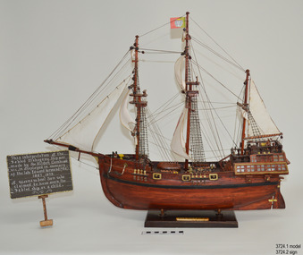 Flagstaff Hill Maritime Museum and Village
Craft - Ship Model, Portuguese Carvel, 1999
... but red gum or ironbark from New South Wales. He was too late... not have been mahogany but red gum or ironbark from New South Wales ...The Mahogany Ship is today regarded as a legend and refers to an ancient wreck that is purported to lie beneath the sand beside Armstrong Bay, several kilometres west of Warrnambool, Its location is currently unknown. For well over a century the mystery of this ship has fascinated Australians because the existence of such a vessel could throw a different light on the earliest phases of exploration of eastern Australia by Europeans. The story is that in January 1836 a party of whalers from Port Fairy travelled to the mouth of the Hopkins River in search of seals. Their boat overturned and one man was drowned. The three survivors were walking the 30 kilometres back to Port Fairy along the coast when, about halfway along, they discovered the wrecked ship in the dunes. It is said that Captain John Mills, who was in charge of the whaling station at Port Fairy promptly visited the wreck with several of his men, including Hugh Donnelly. Donnelly who was the originator of that version of events is now regarded as unreliable. Local history researcher Joan Fawcett believes Donnelly could not have visited the wreck in 1836 because he did not arrive in Victoria until 1841. The "mahogany" description can be traced to a letter from Port Fairy builder, architect and surveyor John Mason and published in the Melbourne Argus in 1876. He said he had seen the hull in 1846 and it "had the appearance of either cedar or mahogany." In 1884 Argus journalist `The Vagabond' wrote that the hull was built of "Spanish mahogany" and six years later Mason wrote another letter saying it might not have been mahogany but red gum or ironbark from New South Wales. He was too late with this new description as the wrecks mahogany tag was here to stay all through the hull was not visible as it had disappeared beneath the shifting sands by 1880. A more reliable account was later presented by the former editor of the Warrnambool Examiner, historian Richard Osburne, who wrote about the wreck in his book History of Warrnambool (published 1887). In it the author remembers to have noticed a wreck in the hummocks between Belfast and Warrnambool, in 1847 or 1848; he stated it was much nearer Warrnambool than Belfast, now known as Port Fairy, going on to state “in fact, it was only two or three miles from the former place, to the west of the big hummock which was supposed to fill Warrnambool Bay with drift sand washed by the Merri River before the cutting was made.” Osburne followed up with a letter to the Port Fairy Gazette on June 25, 1876, during a period of heightened interest in the wreck, although he was unsure of the provenance of the ship he went on to state in his letter. “The old wreck was, in fact, miles away from the Port Fairy beach, and only about four miles from Warrnambool. In the years 1847 and 1848. I have often seen the wreck and I regret to say I do not believe she was a foreign ship at all.”The ship model is significant for its association with the Warrnambool story of what is now referred to as the Mahogany Ship, an ancient shipwreck. The model is significant as it is an interpretation of a Portuguese caravel and possibly associated with the early history and exploration of Southern Australia. The model is a fine example of a hand crafted ship made from plans, not from a kit. Some of the materials used for the model are significant to the Gembrook community in that the timber used is a portion from a 30-meter pine tree that fell onto and destroyed the 120-year-old Gembrook church building. The model is also a dedication to Edward Kermond, who grew up in Warrnambool and claimed to have seen the shipwreck in the dunes when he was a lad in the late 19th century. (See note section of this document for further information on the creator and donation of the subject item).Ship model, an interpretation of a mahogany Portuguese carvel vessel in a glass display case with wood frame and a description plaque. Model is made from dark stained wood. The three masted vessel is fully rigged, with a Portuguese-like flag on mast. Plaque is rectangular, free standing on a pedestal. The model was handmade by Joe Hilder (Senior) in 1999 from flooring obtained from the Gembrook Uniting Church in Victoria. Inscriptions, hand written, under base of case and on plaque.Under base, black felt tip pen “Ship & Case made From / Flooring from Gembrook uniting Church, Flattened in 1999 / By Large Pine Tree.” On plaque, white paint "This interpretation of the Fabled Mahogany Ship was made by Joe Hilder, Gembrook Vic. is displayed in the memory of the late Edward Kermond (Ted) 1887-1973, a Warrnambool son who claimed to have seen the original ship as a child." flagstaff hill, warrnambool, flagstaff hill maritime museum, shipwreck coast, flagstaff hill maritime village, great ocean road, ship model, mahogany ship, mahogany ship story, portuguese caravel, joe hilder, edward kermond, ted kermond, gembrook uniting church, gembrook storm 1999, port fairy whalers, belfast whalers -
 Bendigo Historical Society Inc.
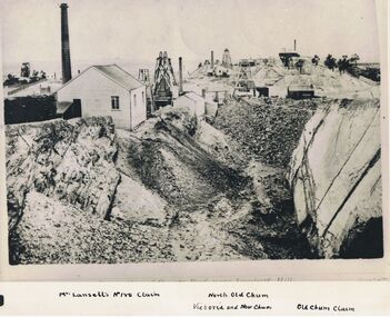
Photograph - LANSELL'S 180 CLAIM, approx. 1875
Black and white photograph of original. Large excavation in foreground. Weatherboard building at left with wood pile and brick chimney. 3 poppet heads in middle distance. 1 poppet head on horizon. Total of 4 chimneys visible. Im inage on original photo ' …. Reef near Ironbark Hill' In margin at bottom ' Mr. Lansell's No. 180 claim/North Old Chum/Victoria and New Chum/Old Chum Claim'Original photo by N.J. Caire, 1875, looking south New Chum or Victoria Reef'organization, business, lansell's 180 claim -
 Bendigo Historical Society Inc.
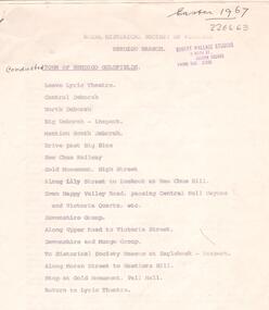
Document - ALBERT RICHARDSON COLLECTION: TOUR OF BENDIGO GOLDFIELD 1967
Seven page printed document. On top 'Royal Historical Society of Victoria, Bendigo Branch. Conducted tour of Bendigo Goldfields.' Easter 1967. Document lists the names and details of mines covered on the tour, including the : Central Deborah, corner Violet and Creek Street North Deborah, Breen Street, Quarry Hill The Deborah, off Adams Street, Quarry Hill The New Chum Railway, Breen Street, Golden Square Eureka Extended South Belle Vue. The Hustlers Hill area history. New Chum Hill history Mines on the New Chum Hill and vicinity: Lansell's 180 New Chum and Victoria The Lazarus New Chum United New Chum consolidated Garibaldi Long Gully mines The Ironbark Carlisle United Hercules Document is signed by A. Richardson.bendigo, mining, mine tour 1967 -
 Bendigo Historical Society Inc.
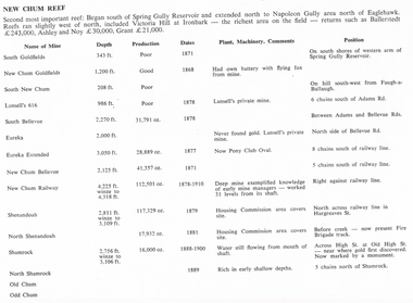
Document - LONG GULLY HISTORY GROUP COLLECTION: NEW CHUM REEF
Six pages titled New Chum Reef. No number on the first page, the others are 109 to 113. Mentions location of the reef and some of the rich mines. The mines are mentioned in a table with the Name of Mine; Depth; Production; Dates; Plant, Machinery, Comments and Position. Ballerstedt, Ashley and Noy, and Grant were three of the successful miners. Mines mentioned are: South Goldfields, New Chum Goldfields, South New Chum, Lansell's 616, South Bellevue, Eureka, Eureka Extended, New Chum Bellevue, New chum Railway, Shenandoah, North Shenandoah, Shamrock, Old Chum, Little Chum, Young Chum, Craven, Garibaldi, Ellesmere, South Old Chum, New Chum Consolidated, North Ellesmere, New Chum United, Lansell's 222, Lansell's Fortuna, Lazarus, West End, Pioneer, Old Chum, New Chum Victoria, North Old Chum, Lansell's Big 180, Sterry, Victoria Quartz, South Adventure, Great Central Victoria, Ballerstedt No 3, Adventure, Humbold, British and American, Midway, Victoria Consuls, Victoria absorbed by Ironbark, Hercules and Energetic, Victoria Pilot, North Hercules and Energetic, Great Extended Hercules, Pearl, Southern Victoria, Great Extended Victoria, Young Victoria, New Catherine Victoria, Weatern Victoria, New Victoria St Mungo, Surprise, Mystery, Duke of Edinburgh, New St Mungo, Duchess Tribute, South Devonshire, Duchess of Edinburgh, West United Devonshire, Albert, United Devonshire, Saxon and Celt, Hopewell, Prince of Wales, Phoenix, Unicorn, South St Mungo, Princess Alice, Lady Barkly, North Devonshire, Ranzeau, St Mungo, Dublin and Cornwall, Sadowa, Eastwood, Ellenborough, Belmont and Saxeby, Snobs Hill, York and Durham, La bElle, Old Williams United, Arcadia, Williams United, South Catherine, Central Catherine, Catherine United, Murchison, New Franklin, Catherine Extended, Pony Club Oval, Housing Commission, Mt Alvernia Hospital, Fortuna, Lunt, Army Survey Unit, Wybrandt, John Brown Factory, Canterbury, Hercules and Energetic and the North Red White and Blue.bendigo, history, long gully history group, the long gully history group - new chum reef, ballerstedt, ashley and noy, grant, south goldfields, new chum goldfields, south new chum, lansell's 616, south bellevue, eureka, eureka extended, new chum bellevue, new chum railway, shenandoah, north shenandoah, shamrock, old chum, little chum, young chum, craven, garibaldi, ellesmere, south old chum, new chum consolidated, north ellesmere, new chum united, lansell's 222, lansell's fortuna, lazarus, west end, pioneer, old chum, new chum victoria, north old chum, lansell's big 180, sterry, victoria quartz, south adventure, great central victoria, ballerstedt no 3, adventure, humbold, british and american, midway, victoria consuls, victoria absorbed by ironbark, hercules and energetic, victoria pilot, north hercules and energetic, great extended hercules, pearl, southern victoria, great extended victoria, young victoria, new catherine victoria, weatern victoria, new victoria st mungo, surprise, mystery, duke of edinburgh, new st mungo, duchess tribute, south devonshire, duchess of edinburgh, west united devonshire, albert, united devonshire, saxon and celt, hopewell, prince of wales, phoenix, unicorn, south st mungo, princess alice, lady barkly, north devonshire, ranzeau, st mungo, dublin and cornwall, sadowa, eastwood, ellenborough, belmont and saxeby, snobs hill, york and durham, la belle, old williams united, arcadia, williams united, south catherine, central catherine, catherine united, murchison, new franklin, catherine extended, pony club oval, housing commission, mt alvernia hospital, fortuna, lunt, army survey unit, wybrandt, john brown factory, canterbury, hercules and energetic, north red white and blue -
 Bendigo Historical Society Inc.
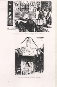
Document - CONSTABLE RYAN COLLECTION: PHOTOCOPY OF CHINESE TEMPLES
Photocopies of Chinese temples, the first one showing ceremonies at the Chinese temple South Melbourne and the second the Chinese temple at Ironbark, Bendigo. The two copies are on the same page and are of poor quality.chinese -
 Bendigo Historical Society Inc.
Document - LONG GULLY HISTORY GROUP COLLECTION: THE BENDIGO POST OFFICE
Article titled The Bendigo Post Office, compiled by L C Bennetts. Mentioned is the history of the Bendigo Post Office and postmarks, some information on mining, Bendigo foundries, Underground connections of mines, expenses and shaft sinking costs. Also mentioned is Bendigo and Eaglehawk - 60 years ago and the role the pubs played in daily living. They were where theatres, concerts and dances were held, and the meeting rooms for clubs and lodges, even church benefits. Listed is a number of Bendigo hotels. Some even had a few names. Names of the pubs are: The Freemasons, The Courthouse, The Commercial Law Courts, The Hamburg, The European, The Prince Bismark, The Lord Kitchener, The Bendigo, The Rosalind Park, The Showgrounds, Atheneum Club, Olivers, Bridge Hotel, Bourkes, The Globe, The Hibernia, Albert, Albion, Abbotts, Australian, Belvidere, Beehive, British Queen, Black Eagle, British and American, Brian Boru, Bakers Arms, Butchers Arms, Brick Layers Arms, Bull and Mouth, Cresent, Clarence, Back Creek Bridge, Cape Clear, Crooked Billet, Cambridgeshire Arms, Camp, Coach and Horses, Cricketers Arms, Diggers Rest, Ellesmere, Five Lions, Franklyn, Golden Square, Golden Gate, Golden Gully, Golden Age, Golden Vine, Gumtree, Glasgow Reef, Great Britain, Haymarket, Daniel O'Connell, Half Way House, Fleece Inn, Ironbark, Johnsons Reef, Lancashire, Live and Let Live, Manchester Arms, Gold Mines, Metropolitan, Crown, National, New Chum, Honeysuckle Street, Pavilion, Napier Arms, Quartz Miners Arms, Retreat Inn, Rainbow, Rose of Australia, Lake View, Robin Hood, Fountain, Southern Cross, Bath, Berlin, Spring Gully, Star, Sir Charles Hotham, Silvermines, Royal Oak, Suburban, Town Hall, Temperance, Ship Inn, View Point, View Bend, Victoria, Exchange, American, Arcade, Belfast, All Nations, Union, United Kingdom, Union Jack, Westend, Washington, Waterloo, Wellington, Whitehorse, Wheat Sheaf, Yorkshire, Niagra and Noahs Ark.bendigo, history, long gully history group, the long gully history group - the bendigo post office, l c bennetts, mt alexander post office, porcupine inn, cenotaph, pike or pyke, baby health centre, sandhurst post office, government survey office, queen elizabeth oval, sandhurst trustees company, mr h b briston, savings bank, telegraph office, the sub-treasury, sir henry brougham lock kcb, sir john nimmo mla, prince of wales group of mines, the new prince of wales, eaglehawk golf links, new prince of wales no 2, the whip and jersey, mines department, lansell's big 180, new chum and victoria mine and battery, new chum railway, koch's pioneer, south new moon, catherine reef united, new moon, the virginia, south bell vue, central nell gwynne, north nell gwynne, miner's phthisis, hercules engine house, ironbark, new chum syncline, hercules energetic, roberts & sons, harkness & co, horwoods, great southern, ulster, carlisle, lansells big 180, victoria quartz, new st mungo, duchess tribute, south devonshire, hopewell mine, saxby mine, mcnair & co, shamrock, mr king, burke and wills expedition, sandhurst hotel, courthouse, hiberian, the freemasons, the courthouse, the commercial law courts, the hamburg, the european, the prince bismark, the lord kitchener, the bendigo, the rosalind park, the showgrounds, atheneum club, olivers, bridge hotel, bourkes, the globe, the hibernia, albert, albion, abbotts, australian, belvidere, beehive, british queen, black eagle, british and american, brian boru, bakers arms, butchers arms, brick layers arms, bull and mouth, cresent, clarence, back creek bridge, cape clear, crooked billet, cambridgeshire arms, camp, coach and horses, cricketers arms, diggers rest, ellesmere, five lions, franklyn, golden square, golden gate, golden gully, golden age, golden vine, gumtree, glasgow reef, great britain, haymarket, daniel o'connell, half way house, fleece inn, ironbark, johnsons reef, lancashire, live and let live, manchester arms, gold mines, metropolitan, crown, national, new chum, honeysuckle street, pavilion, napier arms, quartz miners arms, retreat inn, rainbow, rose of australia, lake view, robin hood, fountain, southern cross, bath, berlin, spring gully, star, sir charles hotham, silvermines, royal oak, suburban, town hall, temperance, ship inn, view point, view bend, victoria, exchange, american, arcade, belfast, all nations, union, united kingdom, union jack, westend, washington, waterloo, wellington, whitehorse, wheat sheaf, yorkshire, niagra, noahs ark -
 Bendigo Historical Society Inc.
Newspaper - LONG GULLY HISTORY GROUP COLLECTION: BENDIGO'S CENTURY VOLUME FOUR: 1930 - 1939
Newspaper supplement titled Bendigo's Century Volume Four: 1930 - 1939. Front page is titled Bendigo's Century and has a photo of some women at the Bendigo Jockey Club, 1930s. Each year has heading of Who's Who, Weather, Sport and Business. First years are 1930 - 1939 titled A look back when. The page has photos of the Eaglehawk Cricket Club's first A Grade cricket premier ship team (1932 - 1933)., The monument to the late Bendigo mining magnate Ernst Mueller in Rosalind Park, The Bendigo Stock Exchange in the early 1930's - pictured are L L Dungey, T Williams, M P Kelly, C Mueller, E Hommoloff, R Kelly, T H Busst, T Hall, R Trembath, E A Woolcock, and C Burridge, the Carshalton mine in 1936 and The Edith and G V Lansell Laboratory at the Bendigo Hospital. 1930 - a photo of St Andrew's Church, the sundial outside the RSL Memorial Hall, The late Monsignor Rooney and The late John Douse Langley. The Ironbark Mine was the top gold producer. 1931 - Radio station goes on air, 1932 - Sir John dies, 1933 Bodyline men come to town, 1934 - Heroic rescues, 1935 - Hospital's new wing opened, 1936 - King mourned, 1937 - Beehive store towers above, 1938 - Mining shows mixed results and 1939 - Outbreak of war sobering.bendigo, history, long gully history group, the long gully history group - bendigo's century - volume four: 1930 - 1939, eaglehawk cricket club, ernst mueller, the bendigo stock exchangel l dungey, t williams, m p kelly, c mueller e hommoloff, r kelly, t h busst, t hall, r tremabath, e a woodcock, c burridge, charshalton mine, edith and g v lansell laboratory, st andrew's church, rsl memorial hall, mr gordon carter, sir john monash, state electricity commission, cr r watson, colonel gt v lansell, empire press congress, bendigo advertiser, mr e j hogan, eppalock weir, lyric theatre, bendigo red cross, mrs george mackay, st andrew's presbyterian church, mrs william hunter, right rev john douse langley, monsignor rooney, bendigo art gallery, the ironbark mine, coliban water, mr w wright, station 3bo, amalgamated wireless of australia ltd, advance bendigo group, the north league, st aidan's orphanage, bendigo freezing works, mr w wright, bendigo advertiser, mr w j stephens, advance bendigo group, north league, garden gully united gold mining company, bendigo football league, sir john quick, john quick snr, ironbark foundry, bendigo evening news, bendigo independent, bendigo advertiser, deakin governmnet, sir charles kingsford smith, southern cross, eppalock weir, bendigo art gallery, the hercules mine, gillies, aids & appliance shop, anne caudle centre, bill woodfull, harold larwood, dr john mccarthy, the hercules, douglas jardine, don bradman, sacred heart cathedral, joseph stapleton, john lynch, bert mcconchie, new red white and blue mine, royal humane society, william james, vernon shaw, south new moon mine, bendigo hospital, bendigo base hospital, duke of gloucester, rsl memorial hall, electricity commission, eaglehawk borough council, the plaza, backhaus estate, amalgamated freezing company, fortuna villa, mrs edith lansell, colonel lansell, the hercules mine, toni riley pharmacy, boardwalk, barkly hyett, the big blue consolidated company, the bendigo hospital, eaglehawk football team, kurmala wing of the bendigo base hospital, sir isaac isaacs, lyric theatre, sir john quick, hanro knitting mills, st luke's toddlers home, st aidan's orphanage, rsl memorial hall, lord and lady huntingfield, cr michelsen, bendigo art gallery, bendigo agricultural show, new blue mine, joseph stapleton, bendigo law association, bendigo hospital committee of management, bendigo rotary club, mr j mcrae, education department, andrew sunstan, sir stanley argyle, bendigo football league, north blue mining company, cr staples, king george v, king edward viii, cr j a michelsen, andrew mclay, bendigo advertiser, cohn bros, mrs wallis simpson, king george vi, capping mine shafts 1936, bendigo art gallery, madge freemen, william john leslie cross, judge wasley, the myer emporium, the baptist church, salvation army, ron masters, the central nell gwyn, sir john quick, leanne mcdonnell, windermere hotel, rev donald baker, john rumbold, central nell gwynne, the beehive building, the beehive store, james buick and co, thomas hope henderson, buick henderson & co, mr goodison, mr r o henderson, lt-col henderson, angus mackay, bendigo sewerage authority, mr s gordon moore, commercial bank of sydney, bendigo advertiser, edward alan morcom, polio, dr gardner kerr, the right rev conald baker, ridley theological college -
 Bendigo Historical Society Inc.
Document - THE BENDIGO GOLDFIELDS - A FEW FACTS, c1970
Document. A Few Facts (7 copies). Two page typed, timelined document on the Goldfield area of Bendigo 1851 1954 by the Bendigo Branch of the Royal Historical Society of Victoria. Mentions Ravenswood sheep run, German Gully, Derwent Gully, Peg Leg Gully, 'The Dascombe' & 'The Victoria' gold nuggets. Watson's Kentish mine in Long Gully, Garden Gully United in Ironbark, The Great Extended Hustlers Tribute on Hustlers Hill, The New Chum United in Golden Square, The Victoria Quartz in Victoria Hill Ironbark, The United Devonshire Mine in Eaglehawk, The Famous Devonshire Valley, Portion of the New Chum Group in Golden Square, The New Moon, The South New Moon, The 'Flying Fox' which conveyed the quartz from the Central Red, White and Blue mine to New Chum Hill, Lansell's'222' Mine, The Mine in the Heart of the City, The Fortuna Hustlers Mine; Snob's Hill, Sailors Gully & Devonshire Gully at Eaglehawk, California Gully, Long Gully, Victoria Hill at Ironbark, New Chum Hill & New Chum Valley at Golden Square, Hustlers Hill & Comet & Redan Hills at North Bendigo.cottage, miners, the bendigo goldfields, a few facts -
 Bendigo Historical Society Inc.
Document - LONG GULLY HISTORY GROUP COLLECTION: GUIDE TO SOME FAMOUS MINES
Three pages titled Guide to Some Famous Mines. Compiled by A Richardson. Each mine is listed as on the reef it is situated on. Reefs are The New Chum Line of Reef and the Garden Gully Line of Reefs, and the Devonshire Group. Mentioned is the mine's location, depth of shaft, poppet legs, machinery, location of engine house, gold yield, dividends and owners of mine. The mines are: The New Chum Line of Reef. The New Chum Railway, Kochs Pioneer, Windmill Hill, Confidence Extended, Johnson's No 1, Johnson's No2, Johnson's No 3, North Johnson's, Princess Dagmar, Golden Age, Johnson's Reef Extended, Golden Pyke, Constellation, Great Northern, Virginia, Specimen Hill United, New Argus, Clarence United, North Argus, South New Moon, New Chum Hill, The New Chum and Victoria, Catherine Reef United. Garden Gully Line of Reefs. The Great Southern, Ulster United, Londonderry, South Garden, The Sea Amalgamated, Garden Gully United, Victory and Pandora, Unity Mine, Carlisle United, Cornish United, Eureka Extended, South Belle Vue United, Shenandoah, Shamrock, New Chum Consolidated, New Chum United, Lansell's 222, Rae's Open Cut, Great Central Victoria, Victoria Consols, The Ironbark, Hercules and Energetic, Pearl, The Devonshire Group. North of Staley,The Duke of Edinburgh, New St Mungo, Duchess Tribute, South Devonshire, Duchess of Edinburgh, Princess Alexandra, West United Devonshire, Hopewell, Phoenix. Yhe Mungo Mines. Unicorn, South St Mungo, Lady Barkly, The St Mungo, Sadowa, Eastwood. Snobs Hill Group. The Ellenborough, The Belmont and Saxby, York and Durham, The Acadia, William's United, The Victoria Hill - Ironbark, The North Old Chum, Lansell's Big 180, Ballerstadt's Open-Cut and The Victoria Quartz.bendigo, history, long gully history group, the long gully history group - guide to some famous mines, a richardson, the new chum railway, kochs pioneer, windmill hill, confidence extended, johnson's no 1, johnson's no2, johnson's no 3, north johnson's, princess dagmar, golden age, johnson's reef extended, golden pyke, constellation, great northern, virginia, specimen hill united, new argus, clarence united, north argus, south new moon, new chum hill, the new chum and victoria, catherine reef united, the great southern, ulster united, londonderry, south garden, the sea amalgamated, garden gully united, victory and pandora, unity mine, carlisle united, cornish united, eureka extended, south belle vue united, shenandoah, shamrock, new chum consolidated, new chum united, lansell's 222, rae's open cut, great central victoria, victoria consols, the ironbark, hercules and energetic, pearl, the duke of edinburgh, new st mungo, duchess tribute, south devonshire, duchess of edinburgh, princess alexandra, west united devonshire, hopewell, phoenix, unicorn, south st mungo, lady barkly, the st mungo, sadowa, eastwood, the ellenborough, the belmont and saxby, york and durham, the acadia, william's united, the victoria hill - ironbark, the north old chum, lansell's big 180, ballerstadt's open-cut, the victoria quartz -
 Bendigo Historical Society Inc.
Document - LANSELL RELATED DOCUMENTS
Document.Copy of Williamstown Historical Society Newsletter No 17 (1977).On the second and third page of this Newsletter is an article entitled ''The guns of the 'Nelson''', written by Doug Mills, Castlemaine. The Warship NELSON underwent alterations in 1860, including cut down to two decks and lengthened, her armaments reduced to 72 guns. Two 7inch 68 pounder guns were added to her armament. In February 7 1867 she was officially given to the Colony of Victoria by the Imperial Government. At the time her Commander was Captain Charles B. Payne. The Warship reached Melbourne in 4th February 1868. Relics of the NELSON were auctioned at Williamstown Victoria Naval Depot, and her two anchors are preserved for public display at Williamstown. An active demand for a share of the guns from various towns in the State. Ballarat received four (4) guns, Bendigo and Castlemaine two (2) each, while one has been given to each of the following towns: - Ararat, Tarnagulla, Hamilton, Bacchus Marsh, Echuca and Geelong. Collection of Lansell related documents: a. Copy of photograph - Lansell's Big 180 Victoria Hill - early 1870s - New Chum Hill in background. B. Lansell Estate mines - compiled from the annual report of the Hon Minister of Mines for Victoria, 1906. A listing of the George Lansell Mining Company interests at the time of his death. These were, New Moon Co, N.L., Clarence, New Prince Of Wales Co. N.L., Virginia G. M. Co., Catherine Reef United Co N.L., Great Northern Co N.L., Williams United, McDuff Amalgamated Co, South Mungo Co, South Prince Of Wales Consolidated, Constellation Co. Golden Pyke Co, Johnson's Reef Extended Company, Golden Age Co., Princess Dagmar Co, New St Mungo Co, Johnson's Reef Co, North Johnson's Co, Collman and Tacchi Co, Confidence Extended Co, G. Lansell Sandhurst Mines, Pearl Co., Windmill Hill Co., United Hustlers and Redan, Koch's Pioneer Co., Hercules and Energetic Co., Lansell's Comet, Cornish United Co., Ironbark Co., Hustler's Reef Co., and No. 1 Lansell's 83, Carlisle Co., Great Extended Hustler's Co., Victoria Consolidated Co., Great Central Victoria Co., Victoria Quartz Co., Victory and Pandora , Lansell's Big 180, Tambour Major, New Chum and Victoria Co., Garden Gully United Co., G. Lansell, Lansell's 222, Lazarus Co., Sea Amalgamated Co., Hustler's Royal Reserve Co., Horwood and Burrowe's Co., New Chum Consolidated Co., G Lansell's Sheepshead, Gariboldi Co., Londonderry Co., Shamrock Co., Great Britain Co., Fortuna Hustler's Co., Eureka Extended Co., G. Lansell's G.V.L., New Red White and Blue Consolidated, Great Southern Co., Lansell's Concord Mines, True Blue Co., G. G. Consolidated Co., Extended Red White and Blue Co., Great Columbian, Sedgwick and New Birthday. Also, a listing: ''Among the biggest yields to ate (sic) (date?) in ozs or Pounds were''; New Moon.Co. N.L. 180,087 ounces, Clarence £303,932, Catherine Reef United N.L. £762,815, Great Northern Co Ltd £394,525, Johnson's Reef Co 277,320ounces, Windmill Hill Co. 113,842ounces, Hustler's Reef Co. And No.1 1,144,923ounces, Carlisle Co 307,835ounces, Great Extended Hustlers Co £1,038,125, Garden Gully United Co. £1,653,900, Great Southern 97,752ounces, New Chum Consolidated 89,526ounces. This part (b) has handwritten inscription ''compiled by J Sarvaas MCE(??) Certified Mining Surveyor; 22/8/06''; c. Copy of Deed dated Dec 1886 between George Lansell, Wooten Lansell and the Bank of New South Wales relating to a wall and windows and openings etc etc. (3 pages of legalese!!!!!). Also, a (related?) page copy of a Grant -by purchase to the Bank of New South Wales with a date of August 1855 on it ''Enrolled in the Office of the Registrar of the Supreme Court of the Colony of Victoria - signed by Acting Registrar.document, gold, mines -
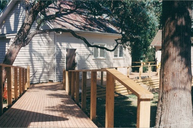 Southern Sherbrooke Historical Society Inc.
Photograph - Verandah being constructed at Original St Martins Church & Hall
A colour photo shows the verandah being constructed at the Original St Martins Church & Hall, Belgrave Heights, in 1995 after their relocation from Belgrave South School. The photo shows the ironbark decking and the base boards in place, plus the partially completed balustrade, all of these components in their raw state. -
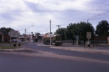 Ballarat Tramway Museum
Slide - 35mm slide/s - set of 19, Noel Simons, 26/02/1972 12:00:00 AM
Set of 18 transparencies taken on 26/2/1972 on Kodak mounts. 1203.1 - Bendigo 5 at Eaglehawk terminus - with new traffic works. 1203.2 - No. 5 climbing the High St. hill Eaglehawk with the buildings on the east side in the photo. 1203.3 - No 2 descending the road over rail bridge at Job's Gully, heading for Quarry Hill. 1203.4 - as for 1202.3, but more side on. Tram has two SEC roof ads. 1203.5 - as for 1202.4 1203.6 - No. 26 entering Garden Gully Loop, Mt. Korong Road, Ironbark. Tram en route to Eaglehawk. Water column on right hand side of photograph. 1203.7 - No. 2 on the Eaglehawk route, Iron Bark area?, bound for Quarry Hill. 1203.8 - as for 1202.7, but photo taken after tram has past photographer. 1203.9 - No. 5 at Eaglehawk terminus, night photo. Tram has arrived at terminus, showing Quarry Hill, pole turned, but the tram lights have yet to be turned around. 1203.10 - as for 1202.9, but lights have been turned around. 1203.11 - No. 26 climbing the View St. Hill near the Commodore Hotel. Has Campbells Electrical Services building in the background. Photo taken after the tram has passed the photographer. 1203.12 - No. 7 end on photograph, at Golden Square, destination showing Golden Square - night photo. 1203.13 - number not used. 1203.14 - as for 1202.12, but partially side on, has a passenger looking out the tram. 1203.15 - as for 1202.12, but with hotel in the background. 1203.16 - No. 26 and 2 at Charing Cross, night photo. Tram 26 en route to Quarry Hill, 2 to Eaglehawk. 1203.17 - Interior photo of No. 26, at night. 1203.18 - No. 26 at the Quarry Hill terminus as night. 1203.19 - as for 1202.18, but central portion of the tramcar.Information written on in blue ink and date stamped on purple ink. 1203.1 - "No. 5 at Eaglehawk terminus" 1203.1 - "No. 5 in High St. Eaglehawk" 1203.3 - "No. 2" 1203.4 - "No. 2" 1203.5 - "No. 2" 1203.6 - "No. 26 at Garden Gully Loop Mt Korong Rd., Ironbark" 1203.7 - "No. 2" 1203.8 - "No. 2" 1203.9 - "No. 5 at Eaglehawk terminus" 1203.10 - "No. 5 at Eaglehawk terminus" 1203.11 - "No. 26 in View St. Near the Commodore Motel" 1203.12 - "No. 7 at Golden Square Terminus" 1203.14 - "No. 7 at Golden Square Terminus" 1203.15 - "No. 7 at Golden Square Terminus" 1203.16 - "Nos. 26 and 2 at Charing Cross" 1203.17 - "Interior of No. 26" 1203.18 - "No. 26 at the Quarry Hill terminus" 1203.19 - "No. 26 at the Quarry Hill terminus "tramways, trams, bendigo, eaglehawk, bridges, iron bark gully, night photo, quarry hill, golden square, tram 2, tram 5, tram 7, tram 26 -
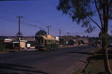 Ballarat Tramway Museum
Slide - 35mm slide/s - set of 25, Noel Simons, 26/02/1972 12:00:00 AM
Set of 25 transparencies taken on 26/2/1972 on Kodak mounts. 1204.1 - Bendigo No. 5 - just arrived at Manchester Loop near Havilah Road, Long Gully. Photo taken after tram has passed photographer. 1204.2 - No. 26 in Backhaus St. Long Gully passing William St, en route to Quarry Hill. Photo taken after tram has passed photographer. 1204.3 - No. 5 climbing the High St. Hill Eaglehawk, heading for Quarry Hill with the buildings on the West side of High St. in the background, including the Eaglehawk Town Hall. 1204.4 - as for 1204.3, but tram close up. 1204.5 - as for 1204.3, but after tram has passed photographer. 1204.6 - No. 5 at intersection of Mt Korong Road Ironbark and Calder Highway, with the AMPOL service 'station in the background. Photo taken after tram has passed photographer. 1204.7 - No. 26 en route to Quarry Hill shortly after leaving Needle Loop, passing William St., Long Gully. 1204.8 - No. 5 at California Gully Loop, picking up a passenger, with the shops at Long Gully in the background. Photo taken after tram has passed photographer. 1204.9 - No. 5 in Long Gully, en route to Quarry Hill. Photo taken after tram has passed photographer. 1204.10 - No. 2 at Eaglehawk terminus with the Eaglehawk Town Hall and Post Office in the background. Tram has two SEC roof ads. 1204.11 - No. 2 at Eaglehawk terminus, close up. 1204.12 - as for 1204.11, but through the park gates. 1204.13 - as for 1204.11, but with tram stop shelters in the foreground and buildings on the West side of High St in the background. 1204.14 - No. 2 in Mt. Korong Rd, midway between California Gully Loop and Needle Loop. Photo taken after tram has passed photographer. 1204.15 - No. 5 in Long Gully, en route to Quarry Hill. 1204.16 - as for 1204.15, but with trams departed loop. Has an ESSO service station in the background. 1204.17 - No. 26 leaves Charing Cross up View St.. Photo taken after tram has passed photographer. Has Armstrong Tyre Service, Cohns Drinks ad on a building and the T&G building in the background. Also Firestone ads on the tyre service building. 1204.18 - No. 5 waits at Charing Cross with the Alexandra Fountain in the background. Tram has two SEC roof ads, 'Everything s fine in my all electric kitchen' and 'Electricity Best for Cooking'. Has RACV, Colonial Mutual Life buildings in the background and the planting areas around Charing Cross gardens in the foreground. 1204.19 - No. 21 en route to North Bendigo arrives at Charing Cross, with passengers waiting to board. No. 5 in the background. In the background is the Fountain Gate Plaza building and the City Family Hotel. 1204.20 - as for 1204.19, but with No. 7 en route to Golden Square. 1204.21 - as for 1204.19, but closer up. 1204.22 - as for 1204.18 1204.23 - No. 25 in Nolan St. near the crossing of Bendigo Creek, running a special tram tour. 1204.24 - No. 25 on a special charter, in Weeroona Ave. at Cnr of Caledonia St. passing the Gas works. 1204.25 - Nos. 25 (showing Golden Square), 7 and 26 at Charing Cross. Has fountain in the background.Information written on in blue ink and date stamped on purple ink. 1204.1 - "No. 5 at Manchester Loop, near Havilah Rd. Long Gully." 1204.2 - "No. 26 in Backhaus St. Long Gully passing William St." 1204.3 - "No. 5 in High St. Eaglehawk." 1204.4 - "No. 5 in High St. Eaglehawk." 1204.5 - "No. 5 in High St. Eaglehawk." 1204.6 - "No. 5 in Mt. Korong Rd., Ironbark, passing Calder Highway Junctn." 1204.7 - "No. 26 shortly after leaving Needle Loop, passing William St., Long Gully. No. 5 cresting hill in distance." 1204.8 - "No. 5 at California Gully Loop." 1204.9 - "No. 5 in Long Gully" 1204.10 - "No. 2 at Eaglehawk terminus." 1204.11 - "No. 2 at Eaglehawk terminus." 1204.12 - "No. 2 at Eaglehawk terminus." 1204.13 - "No. 2 at Eaglehawk terminus." 1204.14 - "No. 2 in Mt. Korong Rd, midway between California Gully Loop and Needle Loop. 1204.15 - "Nos. 2 and 26 crossing at Long Gully." 1204.16 - "No. 26 leaves Long Gully loop for Eaglehawk as No. 2 pulls out of the far end towards Bendigo" 1204.17 - "No. 26 beginning the climb up View St. from Charing Cross." 1204.18 - "No. 5 at Charing Cross." 1204.19 - "No 21 arrives at Charing Cross from Golden Square while No. 5 awaits departure time for Eaglehawk." 1204.20 - "Nos. 7, 21, and 2 (behind which is No. 5) at Charing Cross." 1204.21 - "Nos. 7, 21, and 2 at Charing Cross." 1204.22 - "No. 5 at Charing Cross." 1204.23 - "No. 25 in Nolan St. near Bendigo creek crossing" 1204.24 - "No. 25 in Weeroona Ave. at cnr of Caledonia St." 1204.25 - "Nos. 25, 7, 26 and 2 (behind 26) at Charing Cross."tramways, trams, bendigo, eaglehawk, long gully, california gully, charing cross, north bendigo, tram 2, tram 5, tram 7, tram 21, tram 25, tram 26 -
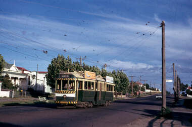 Ballarat Tramway Museum
Slide - 35mm slide/s - set of 6, Noel Simons, 28 Feb. 1972
Set of 6 transparencies taken on 28/2/1972 on Kodak mounts. 1206.1 - Bendigo No. 5 at Hayes St. Loop, en route for Quarry Hill. 1206.2 - No. 5 at Garden Gully Loop, Mt. Korong road, Ironbark. en route to Quarry Hill. Note the water column in the background. 1206.3 - No. 5 in View St. Bendigo, with the Commodore Motel in the background. 1206.4 - No. 6 en route for Golden Square in Fire Station loop, with the fire station building in the background. Photo taken after tram has passed photographer. 1206.5 - No. 6 in High St., running through Golden Square Shopping Centre, en route for Golden Square. Photo taken after tram has passed photographer. 1206.6 - No. 6 arriving at Charing Cross, bound for North Bendigo, with the City Family Hotel, ANZ bank and the Cenotaph (war memorial) in the background.Information written on in blue ink and date stamped on purple ink. 1206.1 - "No. 5 at Hayes Loop, Ironbark." 1206.2 - "No. 5 at Garden Gully Loop, Mt. Korong road, Ironbark." 1206.3 - "No. 5 in View St. just after start of double track near Barnard St." 1206.4 - "No. 6 in High St. at Fire Station loop." 1206.5 - "No. 6 in High St. running through Golden Square shopping centre." 1206.6 - "No. 6 arriving at Charing Cross from Golden Square."tramways, trams, bendigo, hayes st. loop, garden gully loop, view st., golden square, charing cross, tram 5, tram 6 -
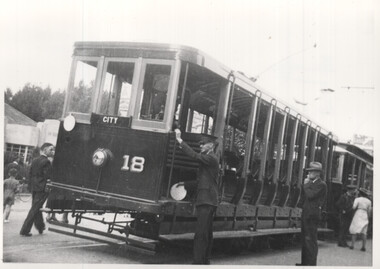 Ballarat Tramway Museum
photograph - Set of 3 Black & White - ESCo trams Bendigo - Easter, Peter Duckett, c1947
Set of three photographs of early Bendigo trams photographed by Peter Duckett, Easter Monday 1946 or 1947 1 - Bendigo 18 - note the white disc held by a crew member. View St at Charing Cross. Tram has the destination of City. 2 - Original car No. 9 (in final form) and open bench car, either 17 or 18, probably at Ironbark Gully loop. Tram has destination of Quarry Hill. 3 - Original ESCo cars - Charing Cross.Yields information about Bendigo trams during Easter 1946 or 1947Set of three black and white photographs by Peter Duckett.Details the image on the rear of the print in ink.bendigo, tramcars, esco, bendigo tramways, tram 18, tram 9, charing cross, easter -
 Bendigo Historical Society Inc.
Document - Hustlers, Sheepshead and Deborah lines of reef
Albert Richardson was a mining historian who wrote widely on the mines of the Bendigo Goldfield. The park opposite the Goldmines Hotel in Marong Road, is named in his honour. Five page document, hand written by Albert Richardson on lined foolscap and edited with cross-outs and insertions, . The mines along the Hustlers line of reef and the Sheepshead line of reef are described. Mines listed on Hustlers line of reef: Fortuna Hustlers (1888 - 1913), shaft 2,240 feet at rear of Buckell and Jeffrey's offices; Royal Hustlers Reserve No. 2 - two shafts 'City" 860 feet, now covered by R.S.L. building Pall Mall, steel poppet legs 60 ft high and 'Park Shaft" at rear of Camp Hill School, 1,775 feet, steel poppet legs 60 feet high; Hustlers Hill Group first worked by Jonathan Harris in 1853 and bounded by Valentine, Anderson and Ironbark Creek to the north and Milroy Street to the east, one of first areas worked for quartz reefing. It with Garden Gully line west and Victoria Hill Ironbark, formed by far the richest cross section of the Bendigo Goldfield. Great Extended Hustlers (1865-1921) close to intersection of Anderson Street and Hustlers Road, mullock heap against road and shored up around shaft, steel poppet legs now at Wattle Gully mine, Chewton, large winding machine, air compressor south of shaft and 36 head crushing battery. Hustlers Reef (Old Hustlers) and Hustlers Reef No. 1, two shafts, main 2,210 feet, about 220 yards east of Moran Street and against Fenton Street. , No. 1 shaft 1,140 feet and about 155 yards east of Moran Street. Lansell's Comet, Lightining Hill line, 2.100 feet, on Comet Hill approx 70 yards west of Holmes Road, near Comet Creek, steel poppet legs. United Hustlers and Redan (1876-1918), main Redan, 1,830 feet about 155 yards west of Sandhurst Roead, in line with Comet Hill State School, this hill known as Redan Hill. North, or New Hustlers, once known as Agnew Hustlers, wooden poppet legs, south side, Kneebone Street, Eaglehawk. Derby line, Johnson's No. 3, South Johnson's (east shaft of Collman and Tacchi) 439 feet on west wide of Woods Street, south of Wetherall Street. Paddy's Gully Line, south to north, some shafts - Lansell's 'Sandhurst" ('Needle") Eaglehawk Road shaft 2,425 feet, about 50 yards east of Needle Loops, a brick square sided chimney with Cleopatra Needle top. British American, 789 feet, just south of Holdsworth Road. Collman and Tacchi, main shaft 2,588 feet, 60 yards west of Eaglehawk Road, California Gully. Deborah Line of Reef, The Deborah (1932-1954) shaft 2.017 feet, west of Adams Road and south of Abel Street, Quarry Hill. North Deborah (1937 - 1954) shaft 1,151 feet, Breen Street, Quarry Hill, steel poppet legs. Central Deborah (1939-1954) shaft 1,347 feet Sheepshead line of reef, Lansell's South Red, White and Blue, shaft 2,124 feet, north east of Bellevue Road and 220 yards east of Adams Road. The New Red, White and Blue Consolidated (Big Blue) main shaft 2,416 feet. Lansell's Bendigo Battery 105 head, north of 'Big Blue" on his freehold lease, commenced crushing on 24th February 1895. After closing was erected as the Showground's Industrial Hall, July 1926. North Red, White and Blue, burnt down February 1926, new company 1934, closed 1938. Document is part of the Albert Richardson Collection of Bendigo mining history. bendigo, gold mining, deborah line of reef, sheepshead line of reef, hustlers line of reef, royal hustlers reserve mine, hustlers hill group of mines, great extended hustlers, hustlers reef no. 1, lightning hill line, old comet, collman and tacchi, lansell's comet, north deborah, central deborah, dhrrpdhrsf linr og trrg, new red, white and blue consolidated mine, big blue, lansell's bendigo battery, north red, white and blue mine, albert richardson collection -
 Bendigo Historical Society Inc.
Document - POPPET LEGS AND ENGINES -WHERE SHIFTED TO
Handwritten notes where poppet legs and engines were taken. New Chum Goldfields - To Golden Fleece. To Deborah. To Central Deb. Carlisle Poppet Heads - to Guilford Plateau, then to Nell Gwynne Reefs. Williams United Engine (Sq Con Reds) - To Ulster then North Blue, then Nth Deborah. Central Blue Engine, with Corliss valves, to Deborah. Windmill Hill Legs to Sebastian, then to Deborah. Big Blue Legs - to Central Deborah. (Legs) South Moon to South Virginia. (Engine) Sth Moon to South Virginia, & driver put on side of drums. Fortuna Hustlers Engine - to ? ?, then to Bird's Reef, then to Herc No 1. Then to Nth Virginia. New Oswald (Malson) Engine left at Sth Moon, not allowed to put in, as it was a loose eccentric. Unity Legs - to Herc. No 1. Then to Ironbark. Ironbark Engine - To Wattle Gully. (Converted to electric winder). 222 - Several Compressors. The fire at the Unity mine in 1907. The fire at the Garden Gully mine in 1911. The fire at the Princess Dagmar in 1913. The light on the Ellenborough flagpole. Tambour Major. Joe Sheard in diving suit. Lansell's Little 180 - Vertical engine. Driver to right side and at floor level. Lansell's bit 180 - Vertical engine. Driver on top of engine. Floor between. Lansell's Needle. - Wooden legs with crossstays reaching from top of legs to close to bottom. Winder - Single Link engine. Hard to get drivers. Confidence Extended. Koch's Pioneer. - Shaft a big angle. Central Blue - Old Sheepshead - same. Vict Catherine - Winder - one drum in front of other, shaft at such an angle. Very hard to see which cage or tank at surface. Specimen Hill and Carlisle - Back-handed first motion engines. Central Nell - Winder from Lord Nelson mine, St Arnaud - Driver behind drums. Turned valve opp. To usual to turn steam on and off.document, gold, poppet legs and engines, shifting about - poppet legs and engines, new chum goldfields, golden fleece, deborah, central deborah, carlisle, guilford plateau, nell gwynne reefs, williams united, ulster, north blue, nth deborah, central blue, windmill hill, sebastian, big blue, south moon, south virginia, fortuna hustlers, tambour major, bird's reef, herc no 1, nth virginia, new oswald (maldon), unity, ironbark, wattle gully, 222, garden gully, princess dagmar, ellenborough, joe sheard, lansell's little 180, lansell's big 180, lansell's needle, confidence extended, koch's pioneer, central blue, old sheepshead, vict catherine, specimen hill, carlisle, central nell, lord nelson mine (st arnaud) -
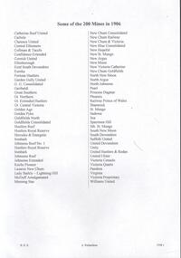 Bendigo Historical Society Inc.
Document - BENDIGO MINES 1906
Handwritten notes mentioning Bendigo Mines. Four mines, Garden Gully United, South New Moon, Hustlers Reef and Catherine Reef United have some information about them. Others listed are: Catherine Reef United, Carlisle, Clarence United, Central Ellesmere, Collman & Tacchi, Confidence Extended Cornish United, Ellenborough, Extd South Devonshire, Eureka, Fortuna Hustlers, Garden Gully United, G G Consolidated, Geribaldi, Great Southern, Gt Northern, Gt Extended Hustlers, Gt Central Victoria, Golden Age, Golden Pyke, Goldfields North, Goldfields Consolidated, North Johnsons, Pearl, Princess Dagmar, Phoenix, Railway Prince of Wales, Shamrock, St Mungo, Sadowa, Sea, Specimen Hill Sth St Mungo, South New Moon, South Devonshire, Suffolk United, United Devonshire, Unity, United Hustlers & Redan, United Ulster, Victoria Consols, Victoria Quartz, Pansora, Virginia, Victoria Proprietory, Williams United, Hustlers Reef, Hustlers Royal Reserve, Hercules & Energetic, Ironbark, Johnsons Reef No 1, Hustlers Royal Reserve, Ironbark, Johnsons Reef, Johnsons Extended, Kochs Pioneer, Lazarus New Chum, Lady Barkly - Lightning Hill, McDuff Amalgamated, Morning Star, New Chum Consolidated, New Chum Railway, New Chum & Victoria, New Blue Consolidated, New Hopefu, New St Mungo, New Argus, New Moon, New Victoria Catherine, New Chum Goldfields, North New Moon and North Argus. Document from Albert Richardson Collection of mining history.document, gold, bendigo mines 1906, bendigo mines 1906, catherine reef united, carlisle, clarence united, central ellesmere, collman & tacchi, confidence extended cornish united, ellenborough, extd south devonshire, eureka, fortuna hustlers, garden gully united, g g consolidated, geribaldi, great southern, gt northern, gt extended hustlers, gt central victoria, golden age, golden pyke, goldfields north, goldfields consolidated, north johnsons, pearl, princess dagmar, phoenix, railway prince of wales, shamrock, st mungo, sadowa, sea, specimen hill sth st mungo, south new moon, south devonshire, suffolk united, united devonshire, unity, united hustlers & redan, united ulster, victoria consols, victoria quartz, pansora, virginia, victoria proprietory, williams united, hustlers reef, hustlers royal reserve, hercules & energetic, ironbark, johnsons reef no 1, hustlers royal reserve, ironbark, johnsons reef, johnsons extended, kochs pioneer, lazarus new chum, lady barkly - lightning hill, mcduff amalgamated, morning star, new chum consolidated, new chum railway, new chum & victoria, new blue consolidated, new hopefu, new st mungo, new argus, new moon, new victoria catherine, new chum goldfields, north new moon, north argus, bgo library 'healthy golden bendigo' - 1906 -
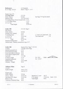 Bendigo Historical Society Inc.
Document - BENDIGO MINES - NOTES ON BENDIGO MINES
Handwritten notes and drawings of mines in Bendigo. Notes contain measurements of pulley wheels, poppet legs, engine houses, chimney and buildings. Mines mentioned are: True Blue Mine, Little 180, Alliance, East Clarence, North Virginia, Ironbark, Ironbark (Sheepshead), Hercules, Stanfield, Hercules No 1, Central Nell Gwynne, North Nell Gwynne, North Deborah, New Chum Syncline, Deborah, True Blue. Notes written by Albert Richardson. Reference A E Kennedy.gold mines, bendigo mines, notes on bendigo mines, a e kennedy, true blue mine, little 180, alliance mine, east clarence, north virginia, ironbark, ironbark (sheepshead), hercules, stanfield, hercules no 1, central nell gwynne, north nell gwynne, north deborah, new chum syncline, new south red white & blue, deborah mine, r g doble, windmill hill mine, true blue, lansell's little 180, south virginia -
 Bendigo Historical Society Inc.
Document - RAE'S CRUSHING BATTERY - THE RICH VICTORIA HILL & ITS HISTORICAL ASSOCIATIONS
The first five pages are photocopies of photos:- 2 of Rae's Crushing Works; Victoria Quartz on Victoria Hill, Ironbark; Looking North from Old Chum Hill to the Victoria Hill; Victoria Hill - from Rae's Open Cut. Introduction covers location of buildings and mines. Mentioned are:- North Old Chum Mine, Ballerstedt's First Open-cut, Quartz Veins (Spurs), rock formations pitching North, Prospecting shafts 1929, Concrete dam, Engine beds of Lansells Big 180 Mine, Lansells Big 180 Shaft, twenty stampers crushing battery, Lansell's Cleopatra Needle type chimney, Victoria Quartz Mine, Victoria Quartz dams, Rae's Open-cut, Quartz once roasted here to an intense heat, Anticlinal Arch New Chum Line, small primitive tunnels, Prospecting tunnels, Floyd's small 5 head crushing battery, Great Central Victoria (Midway) Shaft, Great Central Victoria engine-bed, Ballerstedt's small 24 yard claim, The Humboldt, Adventure ground, The Advance, Luffsman & Sterry's Claim, A round shaft. Small piece of paper with 'Notes on Victoria Hill complete. Notes prepared by Albert Richardson.document, gold, rae's crushing battery, rae's crushing battery, rae's crushing works, victoria quartz mine, from old chum hill, victoria hill from rae's open cut, ironbark, hercules & energetic, midway, wittscheibe, great central victoria, mr & mrs conroy, central nell gwynne, gold mines hotel, john brown knitwear factory, new chum & victoria, rotary club of bendigo south, north old chum, ballerstedt's first open-cut, lansell's big 180 shaft, cleopatra needle type chimney, a roberts & sons, mr e j dunn, h harkness & sons, eureka extd, new chum railway, pearl, inrush of water at victoria quartz, floyd's small 5 head crushing battery, great central victoria (midway), ballertedt's small 24 yard claim, humboldt, humboldt, great central victoria, victoria hill, bendigo & vicinity 1895 p51, j n macartney 1st edition 1871, bendigo goldfield registry 1871, plan of new chum line, mr rae anderson, annals of bendigo obituary 1904, bendigo advertiser, b m l records mines dept, patterson's goldfields of victoria, dickers mining record 23/11/1861, australian mining standard special edition 1/6/1899 p40, bendigo mines ltd, chinese joss house, fortuna, the victoria goldfield 1851 to 1954, the victoria hill 1854 to 1949 -
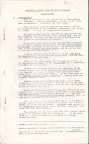 Bendigo Historical Society Inc.
Document - VICTORIA HILL - THE RICH VICTORIA HILL AND IT'S HISTORICAL ASSOCIATION
Two copies of document : nineteen handwritten pages of notes on 'The Rich Victoria Hill and Its Historical Association' Signed by A Richardson and dated 30 - 8 - 1971. and a typed copy of same. Notes include: Introduction, Hotels, Mines, Mining History and descriptions of features where the signposts are. Mines mentioned in the text are: North Old Chum. Ballerstedt's first open cut, Lansell's Big 180. 20 head stamper, Lansell's Cleopatra Needle, Victoria Quartz Mine. Cleopatra's Needle was a square sectioned brick chimney with this four sided pyramidal chimney top with four vents to allow the smoke to escape whatever the direction of the wind. It was demolished in the 1950's as it had a bend in it and it was considered unsafe. Lansell had two other mines with similar chimneys, the '222' in Chum Street and his 'Sandhurst' or 'Needle' mine near the Bendigo, Eaglehawk boundary. Notes prepared by Albert Richardson.mine, gold, victoria hill, victoria hill, the rich victoria hill and it's historical association, j. n. macartney, quartz miner's arms hotel, ironbark methodist church, greek orthodox church, john brown knitwear factory, little 180 mine, geo lansell, conrad heinz, british & american hotel, victoria reef gold mining coy, manchester arms hotel, housing commission homes, ironbark (victoria reef gold mines, hercules and energetic, midway, wittscheibe, gt central victoria, wm rae, mr & mrs conroy, wm rae jr, central nell gwynne, moorhead's shop, gill family, gold mines hotel, david chaplin sterry, pioneer, new chum and victoria, burrowes and sterry, new chum and victoria tribute, rotary club of bendigo south, big 180, victoria quartz mines, jeweller's shop, bendigo and district tourist association, north old chum mine, john wybrandt, ballerstedt's first open-cut, j c t christopher ballerstedt, ballerstedt's mine, bendigo cemetry, lansell's 'cleopatra nedle' type chimney, 222 mine, sandhurst or 'needle' mine, victoria quartz mine, victoria reef quartz company, mr e j dunn, eureka ext'd, new chum railway, pearl, bendigo advertiser 16 june 1910, victoria consols, shamrock, shenandoah, victoria quartz dams, rae's open cut, prospecting tunnels, floyd's small 5 head crushing battery, gt central victoria (midway) shaft, midway no 2, midway north, ballerstedt's small 24 yard claim, the humboldt, the tribute coy, advance, luffsman and sterry's claim, a round shaft, chinese joss house, lansell's fortuna, p m g repeater station, a richardson -
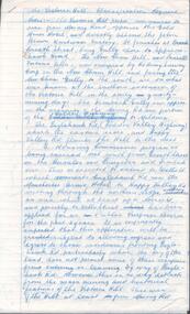 Bendigo Historical Society Inc.
Document - VICTORIA HILL - CLASSIFICATION REQUEST
Handwritten, 3 page carbon copy of a classification request for victoria Hill. Notes give locality, housing program in the area, immediate surrounds of the area, prominent citizens, buildings, mines, geographical formations and gold production. Notes prepared by Albert Richardson.mining, parish map, victoria hill, classification request for victoria hill, gold mines hotel, john brown knitwear factory, lansell's fortuna villa, army survey corp, housing commission, hercules, energetic, ironbark, manchester arms hotel, bendigo goldfield, old miners homes, george lansell, sir george lansell, bendigo advertiser, theodore ballerstedt junior, mr c t c johann ballerstedt, mr wm rae, david sterry, adventure, wittscheibe's 'jewellers shop', luffsman & sterry's rich claim, ballerstedt open cut and mine, lansells 180, victoria quartz, rotary club of bendigo south, bendigo cemetry -
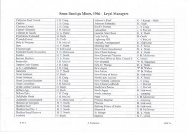 Bendigo Historical Society Inc.
Document - MINING REPORTS - LIST OF LEGAL MANAGERS
Handwritten list by Albert Richardson, with typed copy of same, of some Bendigo Mines and their Legal Managers, as at September 30th, 1906. Document is part of the Albert Richardson Collection. document, gold, miner's right, mining reports, list of legal managers, j h craig, j h mccoll, g a petrie, h birch, b crofts, h y north, h kirkwood, s h mcgowan, g j keogh, c moore, w g blackham, w b walker, j humming, g h green, catherine reef united, carlisle, clarence united, central ellesmere, collman & tacchi, confidence extended, cornish united, daly & westons, don, ellenborough, extended southdevonshire, eureka, fortuna hustlers, fosterville, garden gully united, g g consolidated, garibaldi, great southern, great northern, great extended hustlers, great columbian, great central victoria, golden age, golden pyke, goldfields north, goldfields consolidated, hercules & energetic, hustlers reef, hustlers reef no 1, hustler's royal reserve, ironbark, johnson's reef, johnsons extended, koch's pioneer, lancashire, lazarus new chum, lady barkly, lightning hill, mcduff amalgamated, morning star, new chum consolidated, new chum railway, new chum & victoria, new red white & blue consolidated, new hopeful, new st mungo, new argus, new moon, new prince of wales, north lady brassey, new victoria catherine, new chum goldfields north new moon, north argus, north johnsons, pearl, princess dagmar, phoenix, railway prince of wales, shamrock, st mungo, sadowa, sea, stewart's united specimen's hill, south st mungo, south new moon, south devonshire, suffolk united, south prince of wales, spring gully junction, true blue, thomas united, united devonshire, unity, united hustlers & redan, united ulster, victoria consols, victoria reef quartz, victory and pandora, virginia, victoria proprietory, williams united -
 Bendigo Historical Society Inc.
Document - MINING REPORTS - LIST OF GOLD MINES OR MINING COMPANIES
Handwritten list, (typed copy) by Albert Richardson, of Gold Mines or Mining Companies. Listed are: Australian United Quartz Co Sandhurst, Advance Co, Big Hill Tribute Co, Birds Reef Railway Reserve Mine Co, British Banner Gold M Co, Brookfield Gold M Co, Carlisle North Garden Gully, Caroline Gold M Co, Central Garden Gully, Charles Gavin Duff Gold M Co, Charleston Quartz, Cinderella Co, Collman Tacchi & Nelson, Confidnece Gold M Co, Cornish United Gold M Co, Derby Gold Mine Co, Dixon's Tribute Co, Ellesmere black Lead Tribute Co 1871, Empire Amalgamated, Extended Gold M Co (Majorca), Extended Co Victoria Reef, First Chance Tribute, Fortuna, Golden Fleece & Heales United, Garden Gully United, Garden Gully, Golden Fleece, Golden Point, Golden Lion Tribute Garden Gully Reef, Great Golden Fleece Co, Great Wonder Co, Gilmons Golden Palm Trib Co, Golden Garden Gully Co 1873, Golden Sovereign Extended Trib Co 1872, Great Extended Garden Gully Co 1874, Great Extended South Hustlers Co 1872, Great Republic Corp, Ironbark Co, Kangaroo Flat Steam Puddling & Qaurtz M Co, Riverpool Gold M Co, Iron Duke Co 1871, Henry Van Der Hugen Pioneer G M Co, Kent M Co, Kentish Co, Mariners Reef Co, Mary Hill Trib Co, Morning Star Gold Mine Co, Mount Korong Lane's Reef M Co, New Chum & Victoria Trib Co, New Hopeful Gold M C, New Homeward Bound, New Lord Warden Trib Co, North Lord Warden Trib Co, North Nelson, North Golden Pyke Co, North Old Chum, North Shamrock, North Birds Reef Co, North Birds Tribute Co, New Chum Freehold, New Era, No 3 Wilson's G M C, Odin Reef Co, Oriental Perserverance G M C, Paddy's Reef Trib Co, Palm Gold M Co, Palm Tribute Co, Pearl Tribute Co, Pegleg Gully Quartz G M C, Pegleg Quartz M C, Princess Dagmar G M C, Prince of Wales Amalgamated (Tarnagulla), Pyrances Gold M C, Passby United G M C, Quartz Hill Quartz M C, Pevieres Victory Trib Co, Royal Oak Quartz, Royal Standard Trib Co, Royal George Quartz G M C, Royal Golden Fleece, Sable Chief G M C, Sainia Reef Quartz M Co, South Fraser Reef G M C, Southern New Chum Gold M C, Shanandoor Tribute, Sebastian Gold M Co, Sophia & Redan G M Co, Youth Bell Vue Co, Shannon Company, South Extended Wallaby Co, South Ramrod Co, South Royal Hustlers Co, South Wallaby Trib Co, United Hustlers, United Hustlers & Redan Co, United Bros Tribute Co (Myrtle Creek), United Gold Mine Co, Victoria Reef Gold M Co, Victorian Consolidated M Co, Victoria Reef Quartz, Virginia Gold M Co, Victory and Pandora, Young Chum, South Homeward Bound Co, South Shilling Co, South Nuggetty Co, South Devonshire Co,South Keep it Dark, Try Again Tribute Co Victoria Hill.document, gold, mining reports, mining reports, list of gold mines or mining companies, australian united quartz co sandhurst, advance co, big hill tribute co, birds reef railway reserve mine co, british banner gold m co, brookfield gold m co, carlisle north garden gully, caroline gold m co, central garden gully, charles gavin duff gold m co, charleston quartz, cinderella co, collman tacchi & nelson, confidnece gold m co, cornish united gold m co, derby gold mine co, dixon's tribute co, ellesmere black lead tribute co1871, empire amated, extended gold m co (majorca), extended co victoria reef, first chance tribute, fortuna, golden fleece & heales united, garden gully united, garden gully, golden fleece, golden point, golden lion tribute garden gully reef, great golden fleece co, great wonder co, gilmons golden palm trib co, golden garden gully co 1873, golden sovereign extended trib co 1872, great extended garden gully co 1874, great extended garden gully co 1874, great extended south hustlers co 1872, great republic corp, ironbark co, kangaroo flat steam puddling & qaurtz m co, riverpool gold m co, iron duke co 1871, henry van der hugen pioneer g m co, kent m co, kentish co, mariners reef co, mary hill trib co, morning star gold mine co, mount korong lane's reef m co, new chum & victoria trib co, new hopeful gold m c, new homeward bound, new lord warden trib co, north lord warden trib co, north nelson, north golden pyke co, north old chum, north shamrock, north birds reef co, north birds tribute co, new chum freehold, new era, no 3 wilson's g m c, odin reef co, oriental perserverance g m c, paddy's reef trib co, palm gold m co, palm tribute co, pearl tribute co, pegleg gully quartz g m c, pegleg quartz m c, princess dagmar g m c, prince of wales amalgamated (tarnagulla), pyrances gold m c, passby united g m c, quartz hill quartz m c, pevieres victory trib co, royal oak quartz, royal standard trib co, royal george quartz g m c, royal golden fleece, sable chief g m c, sainia reef quartz m co, south fraser reef g m c, southern new chum gold m c, shanandoor tribute, sebastian gold m co, sophia & redan g m co, youth bell vue co, shannon company, south extended wallaby co, south ramrod co, south royal hustlers co, south wallaby trib co, united hustlers, united hustlers & redan co, united bros tribute co (myrtle creek), united gold mine co, victoria reef gold m co, victorian consolidated m co, victoria reef quartz, virginia gold m co, victory and pandora, young chum, south homeward bound co, south shilling co, south nuggetty co, south devonshire co, south keep it dark, try again tribute co victoria hill. -
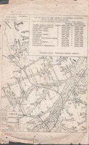 Bendigo Historical Society Inc.
Document - MINING REPORTS - MAP OF PART OF THE BENDIGO GOLDFIELD INCLUDING WHITE HILLS AND EAGLEHAWK
BHS CollectionMap of part of the Bendigo Goldfield including White Hills and Eaglehawk. Map shows reef lines, gullies, railway line, tram route, type of rock, name of mine, Calls and Dividends. Also Deepest Mine Victoria Quartz 4614 ft. Names of Mines are Garden Gully United, Great Ext'd Hustlers, Johnson's Reef, South New Moon, New Moon, Catherine Reef, Virginia, Central Red White & Blue, Ironbark, Kock's Pioneer, Carlisle and the Hercules & Energetic. Map is part of the Albert Richardson Collection of mining documents and research. document, gold, mining reports, mining reports, map of part of the bendigo goldfield including white hills and eaglehawk, pabst bendigo goldfield, garden gully united, great ext'd hustlers, johnson's reef, south new moon, new moon, catherine reef, virginia, central red white & blue, ironbark, kock's pioneer, carlisle, hercules & energetic. victoria quartz