Showing 315 items
matching street tree plantings
-
 Marysville & District Historical Society
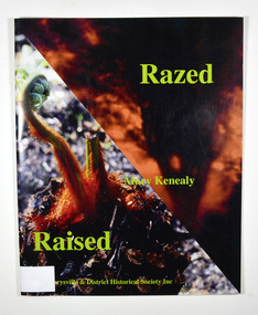
Book, Razed-Raised, 2013
The story of the regrowth of the Marysville community after the 2009 Black Saturday bushfirePaperback. Front cover has two colour photographs. One is a blurred photograph of a silhouette of a tree with fire behind it. The other is of a plant just starting to grow. Back cover has the symbol depicting Maryville's 150 anniversary in 2013. Stamp of Marysville & District / Historical Society Inc / P.O. Box 22 / Marysville 3779marysville, black saturday, bushfire, community, triangle community, regrowth -
 Marysville & District Historical Society
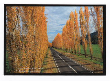
Postcard (item) - Colour postcard, Donovan Wilson, 'GOULDS MEMORIAL DRIVE'- Buxton Marysville Road, Post 2009
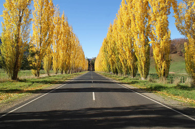
A colour photograph taken of Gould Memorial Drive on the Buxton Marysville Road in Victoria.A colour photograph taken of Gould Memorial Drive on the Buxton Marysville Road in Victoria. The planting of the avenue of Lombardi Poplars was initiated by Mrs Joy Gould and the trees were planted by workers of the Gould Mill. The intention was for the avenue to extend from Marysville to Buxton. However, this was never fully realised. In Autumn the trees turn a brilliant yellow and are a major tourist attraction. This postcard was produced by Donovan Wilson Photography as a souvenir of Marysville.Gould Memorial Drive/ Buxton Marysville Road/ Marysville Donovan Wilson/ Photography Place/ Stamp/ Heremarysville, buxton, poplar trees, gould memorial drive, donovan wilson, postcard, souvenir, marysville-buxton road -
 Marysville & District Historical Society
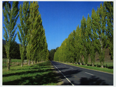
Photograph (Item) - Colour photograph, Unknown
A colour photograph of Gould Memorial Drive which is on the Marysville-Buxton Road near Marysville in Victoria.A colour photograph of Gould Memorial Drive which is on Marysville-Buxton Road just outside Marysville in Victoria. The planting of the avenue of Lombardi Poplars was initiated by Mrs Joy Gould and the trees were planted by workers of the Gould Mill. The intention was for the avenue to extend from Marysville to Buxton. However, this was never fully realised. In Autumn the trees turn a brilliant yellow and are a major tourist attraction. john lloyd gould, joy gould, gould mill, gould memorial drive, marysville-buxton road, marysville, buxton, victoria, photograph, lombardi poplars -
 Marysville & District Historical Society
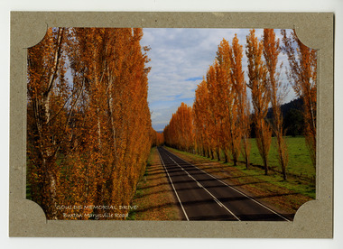
Photograph (item) - Colour photograph, Donovan Wilson, 'GOULDS MEMORIAL DRIVE'- Buxton Marysville Road, Post 2009
A colour photograph taken of Goulds Memorial Drive on the Buxton Marysville Road in Victoria.A colour photograph taken of Goulds Memorial Drive on the Buxton Marysville Road in Victoria. The planting of the avenue of Lombardi Poplars was initiated by Mrs Joy Gould and the trees were planted by workers of the Gould Mill. The intention was for the avenue to extend from Marysville to Buxton. However, this was never fully realised. In Autumn the trees turn a brilliant yellow and are a major tourist attraction. marysville, buxton, poplar trees, gould memorial drive, donovan wilson, postcard, souvenir, marysville-buxton road -
 Marysville & District Historical Society
Photograph (Item) - Colour photograph, Unknown
A digital copy of a colour photograph of Gould Memorial Drive which is on the Marysville-Buxton Road near Marysville in Victoria.A digital copy of a colour photograph of Gould Memorial Drive which is on Marysville-Buxton Road just outside Marysville in Victoria. The planting of the avenue of Lombardi Poplars was initiated by Mrs Joy Gould and the trees were planted by workers of the Gould Mill. The intention was for the avenue to extend from Marysville to Buxton. However, this was never fully realised. In Autumn the trees turn a brilliant yellow and are a major tourist attraction. john lloyd gould, joy gould, gould mill, gould memorial drive, marysville-buxton road, marysville, buxton, victoria, photograph, lombardi poplars -
 Conservation Volunteers
Memorabilia: Cyclone Sylvaspade, Australian Bicentenary 1988, Cyclone Sylvaspade - Senator Graham Richardson planted a tree using this spade at Sovereign Hill Outdoor Museum to mark ATCV's work at the Australian Bicentennial, 1988 (exact)
The spade is a memento of the planting of a tree by the responseible Commonealth Minister to recognise the contribution of ATCV and ATCV volunteers to repair of the Australian environment. At the time ATCV had been operating in Ballarat for six years. ATCV volunteers had planted 192,000 trees from April 1987- March 1988. Senator Richardson was then Minister for the Arts and the Environment in the Hawke ALP Government and on 17 November 1988 he planted a tree using this spade at Sovereign Hill Outdoor Museum (at which ATCV volunteers had planted trees which are (by 2010) fully grown and a significant feature of the site). Peter Hiscock was director of Sovereign Hill as well as President of ATCV and among the most significant leaders of ATCV (now CVA). The spade also symbolises the recovery of ATCV (then a small and struggling community group) from near closure owing to the effects of the 1987 recession. The Cyclone Sylvaspade concept was component project of the Australian Bicentennial celebrations aimed at recognising organisations which had contributed positively to conservation of Australia's environment. The concept was originated and driven by Dr Wilf Crane of the CSIRO Division of Forestry and a highly regarded forester and environmentalist and champion of the cause of rejuvenating Australia's degraded landscape with trees. At the naming of a road after him in Canberra he was described as a: "enthusiast, a man of conviction, action, humility and simplicity". Wilf conceived the project, developed the tree planting spade with Boral Cyclone and the Institute of Foresters of Australia and launched it with the then Governor-General Sir Ninian Stephens at the new Parliament House. Cyclone has been a brand name for a manufacturer of good quality hand tools for over a century. It is likely manufacturing was still done in Australia at the time of manufacture of the Sylvaspade. Much of it has now moved offshore, particuarly to China and Taiwan.This object is historically significant because it is a memento of a significant national event, the 200th anniversary of European settlement and the start of a process of environmental change which has had negative consequences and which demands a commitment to conserving the uniques Australian national environment. It recognised the achievement of ATCV in tree planting over six years. The Cyclone Sylvaspade is a practical memento and having the responsible Commonwealth Minister plant a tree with it was highly symbolic of ATCV's practical commitment to repair of our environment all over Australia. It was also used by the Victorian Premier, Hon John Brumby, to plant a tree at the reopening of the Boral Asphalt plant, Ballarat, in April 2010. The spade is No. 12 of a limited edition. This item is a functional tree planting spade called a "Cyclone Sylvaspade", mounted on a block of wood with a plaque. The handle of the spade is made of grey plastic, the haft is light, stained wood, and the blade is manufactured to resemble silver and has engravings. It was donated by the Boral company and presented to ATCV by the Minister of Arts and the Environment, Senator Graham Richardson after he had planted a tree to mark the occasion at Sovereign Hill Outdoor Museum, BallaratOn the stem of the spade here is a label showing the logo of the Boral company which reads "SYLVASPADE Tree Planting Spade - Made in Australia." On the blade is engraved "Cyclone - NUMBER 0012 - SYLVASPADE - 1788-1988" together with the logo of the Australian Bicentennial Authority. The spade is mounted on a sturdy polished wooden board on which there is a brass-coloured plate bearing the words: "PRESENTED BY SENATOR THE HON GRAHAM RICHARDSON TO AUSTRALIAN TRUST FOR CONSERVATION VOLUNTEERS IN RECOGNITION OF THEIR CONTRIBUTION TO THE ENVIRONMENT 17TH NOVEMBER 1988 DONATED BY BORAL LIMITED"of, trust, ballarat, memento, australian, australia, environment, conservation, atcv, for, volunteers, cyclone, sylvaspade, senator graham richardson, 1788 1988 australian, bicentennial, boral, spade, sovereign hill, 17th november 1988, 1988, minister for arts and environment, tree planting, institute, foresters, dr, wilf, crane -
 Phillip Island and District Historical Society Inc.
Photographs, Gary Field, 1963
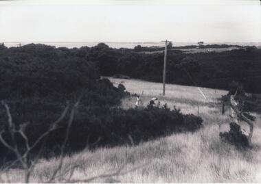
Photographs taken by Gary Field. Lady in photos is Gary's mother. She planted Angophora trees near corner of Daffyd Street and Appley Avenue. (Information supplies by John Eddy).Four black & white photographs of panoramic views from and of Daffyd Street, Red Rocks in 1963, looking north with French Island and the Peninsula on the horizon, view of houses and caravans in Daffyd Street and showing local scrub and housing.daffyd street red rocks, red rocks phillip island, houses 1960's, gary field -
 Phillip Island and District Historical Society Inc.
Photographs, 30/11/2009
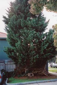
This is a collection of 12 coloured photographs of the Warley Hospital and Nursing home donated by Meg Davis. In 1923 the Warley Hospital was established in a house purchased by Mr Thompson. The new hospital was built in 1962 and the Nursing Home Annex was added in the mid 1970's. The Hospital was closed January 31st 2008.Colour Photograph 1 Cyprus Tree in grounds of the Warley Hospital with Plaque mounted on Granite plinth at base. Colour Photograph 2 Warley Avenue Cowes, Phillip Island with trees lining the street. Colour Photograph 3 Plaque mounted on Granite plinth stating "This tree was planted at the Diamond Jubilee Celebration 4-12-1983 by Mr Peter J Berwick, President Victorian Bush Nursing Association" Colour Photograph 4 Warley Avenue Street Sign mounted on concrete pole. Colour Photograph 5 Warley Hospital driveway alongside front entrance. Colour Photograph 6 Warley Hospital with "Expressions of Interest" Sign in foreground with SOLD across the sign. Colour Photograph 7 Warley Hospital Nursing Home. Colour Photograph 8 Warley Hospital front view with garage underneath. Colour Photograph 9 Warley Hospital Nursing Home. Colour Photograph 10 Warley Hospital front close up view of garage entrance and Nursing home to the right in the background. Colour Photograph 11 Warley Hospital Main Entrance. Colour Photograph 12 Warley Hospital original Medical Centre - now Consulting Rooms. warley hospital cowes phillip island, hospitals, warley nursing home cowes phillip island, warley avenue cowes phillip island, meg davis -
 Greensborough Historical Society
Photograph - Photograph Collection, Greensborough War Memorial Park Sculptures, 2003c
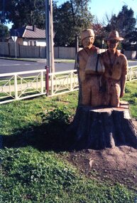
Sculptures created from stumps of trees planted around Greensborough War Memorial park. This collection is by an unknown photographer.Memorial to past armed services people from Greensborough District.Set of 8 photographs of chainsaw sculptures in Greensborough War Memorial Park.greensborough war memorial park, sculptures, ester street, leigh conkie, chainsaw sculptures, war memorials -
 Mission to Seafarers Victoria
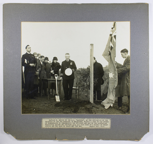
Photograph - Photograph, Black and white, Herald, Captain R. Sunter of the M.S. Manunda , at the invitation of the War memorial in Melbourne, plants a tree, 04 August 1934
On the 4 August 1934, to mark the 20th anniversary of the Great Britain declaration of war on Germany, 106 trees were planted, during a ceremony, on the lawns of the newly created garden of the Shrine of Remembrance. The Shrine of Remembrance was built to provide a place to grieve and remember Victorians killed in the First World War (1914-18). Prince Henry, the Duke of Gloucester and son of King George V, officially opened the Shrine before a crowd of 300,000 people in November 1934. Captain Robert Sunter, commander of the coastal liner Manunda, Adelaide Steamship Company, was chosen to plant a Queensland kauri (tree - number 100) on the main avenue from Domain Rd leading to the Shrine of Remembrance. The photograph was published in the Herald (4 August 1934, p. 40). In the Argus (Melbourne, Vic. : 1848 - 1957), Friday 3 August 1934, page 8 In Memory of the Merchant Service- Captain Sunter to Plant Tree at the Shrine Tomorrow will be the 20th anniversary of Great Britain's declaration of war on Germany, and at 10 and. Captain R. Sunter, the commander of the coastal liner Manunda, will plant a tree in the Shrine! of Remembrance reserve In memory of the officers and men of the Australian merchant service who gave their lives during the war. The tree, , which will be No.100 in the reserve, will bear the following inscription based on the wording of the ' British Mercantile Marine memorial at Tower Hill. London: "1914-1918. In remembrance of the officers and men of the Australian Mercantile Marine who died for King and Country and have no grave but the sea. Planted August 4, 1934." During the war 12 ships of the Australian merchant service were sunk and 95 officers and men lost their lives.The Shrine of Remembrance committee recently asked the director of navigation (Captain J. K. Davis) to nominate a member of the mercantile marine to plant a tree in the reserve. Captain Davis passed on the request to the secretary of the Merchant Service Guild of Australia (Captain T. D. Snape) and, after having conferred with various sections of the sea-going service, Captain Snape announced yesterday that Captain Sunter had been chosen unanimously. Captain Sunter has a distinguished war record as commander of the hospital ship Wandilla. Born at South Shields, in England, in 1878, he is a son of the late Canon Sunter, of Adelaide. He served an apprenticeship in sailing ships, and soon after obtaining his master a certificate entered the service of the Adelaide Steamship Company, where he has remained. In the Wandilla during the war Captain Sunter became known to thousands of wounded soldiers and troops." Padre Frank Oliver of MtS can be seen assisting with dedication at far left. Captain Robert Sunter who also served in WW1, a friend of the seamen and the mission, died a month later in Cairns. A window funded by crew of the Manunda and friends was dedicated to his memory in St Peter's Chapel, MtSV in February 1936 by Padre Oliver. (see item 0038).Depicts one of the few memorials specifically commissioned for Merchant seamen of WW1 and in later years also a focus for those who died in WW2 and other conflicts. Mounted black and white photograph of a group of people at a tree planting, minister of religion at far left, on dark grey mount with typed caption label on the lower edge of mountTyped caption in upper case: CAPTAIN R. SUNTER OF THE M.S. “MANUNDA”, AT THE INVITATION OF THE TRUSTEES OF THE WAR MEMORIAL IN MELBOURNE , PLANTS A TREE IN THE AVENUE OF REMEMBRANCE TO COMMEMORATE THE OFFICERS AND MEN OF THE AUSTRALIAN MERCANTILE MARINE WHO BETWEEN 1914 AND 1918 DIED AS A RESULT OF ENEMY ACTION AND WHO HAVE NO GRAVE BUT THE SEA. AUGUST 4TH 1934padre oliver, captain robert sunter, m.s. manunda, war memorial, mercantile marine memorial tree, melbourne, shrine of remembrance, wandilla, hospital ship, adelaide steamship company, memorial trees, queensland kauri -
 Mission to Seafarers Victoria
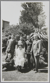
Photograph - Photograph, Black and white, Mrs Weller, A Sunday lunch group in the Chaplaincy garden, Dec. 1925, December 1925
Dora Walker (married 1928 taking the name Simpson) had a long association with the Mission as a member of the Ladies Harbour light guild. This image is similar to another image in the collection which depicts the garden of the Walker family where many fund-raising events and hosting of seafarers took place. Rev Weller dates the image to around mid to late 1920s. In the 1960s and 70s Dora was president of the LHLG which later merged with the Flying Angels. She was awarded the MBE for her services to the community in the 1970s. Dora's son David Simpson is a volunteer still iat MTS n the 21stC. The Walker and Simpson families are examples of long association and commitment supporting the Mission to Seafarers. As they are researched it is clear the stories of these families document not only support for the Mission but are also shown to have been significant contributors, leaders and donors to the broader Melbourne and Victorian community from the 19th Century and up to the present day. The photograph shows the garden in its early years.Group portrait depicting 4 men in suits standing (reverend Weller on the right), a man sitting on the grass, next to a woman in white summer dress (Dora Walker), sitting on a chair in front of the men. They are photographed outdoor probably in the mission's garden (in the background we can see the letters E-EX on a building wall, thought to be from the Extension Bond and Free Stores located next to the mission at the time)dora walker, reverend reginald weller, picnic, cadets, officers, lhlg, amy dora walker, dora simpson, mission's garden, flinders street, mission to seafarers, seamen's mission, mission to seamen, ladies harbour lights guild, melbourne, lawn, grass, trees, plants, peppercorn tree, weller album, dora simpson nee walker -
 Phillip Island and District Historical Society Inc.
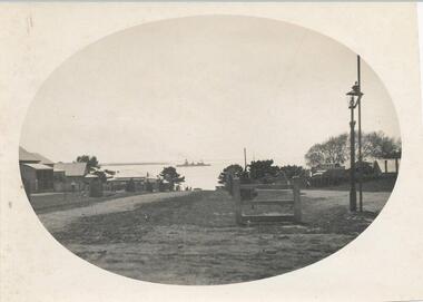
Photograph, Thompson Avenue, Cowes Phillip Island, 1920
This is from Jessie Smith's collection presented by Stan McFee. The vessel is HMS Australia. Avenue shows young Cypress trees planted in 1912 approx.Black & White Photograph of Thompson Avenue, looking north across Western Port Bay. Silhouetted ship in middle. Young Cypress in middle with lamp-post and pole at extreme right.HMS Australia 1920 Coweslocal history, photographs, mains street - streetscape - cowes, phillip island, black & white photograph, jessie smith, main street cowes 1920, stan mcfee -
 Phillip Island and District Historical Society Inc.
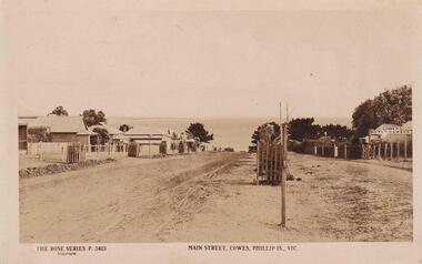
Photograph, 1911-12
Part of collection donated to the Museum by Mr. Bernard Grayden. 1975View down Main Street to Bay and newly planted Cypresses within tree guards approx 1911-1912Main Street, Cowes, Phillip Island, Victoria. The Rose Series P 3413local history, documents, postcards, cowes, phillip island, sepia postcard, cypresses -
 Mortlake and District Historical Society
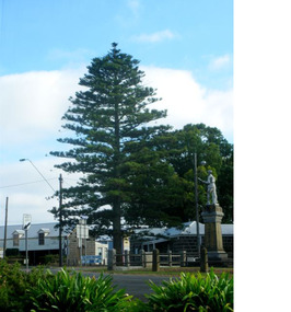
The Peace Tree
This Norfolk Island pine tree was planted in 1919 as 'The Peace Tree'. A community gesture signifying the embrace of 'peace' as a valuable concept symbolised by the planting of a tree. [from Mortlake Dispatch] PEACE DAY 1919. Throughout the Empire three days were marked as Public Holidays including Peace Day in July 1919. Mortlake observed Peace Day by Peace Medals being distributed at the State School, Union Jacks being flown from many buildings and houses and the Peace Tree being planted at the intersection of Officer Street, Jamieson Avenue and Shaw Street. Then followed a procession [of local people]. It is assumed the Progress Association, which undertook the Avenue of Honour, also was responsible for planting the Peace Tree. Norfolk Pine tree located on eastern corner of Officer Street, Shaw Street and Jamieson Avenue intersection.1919, peace, norfolk island pine -
 Mortlake and District Historical Society
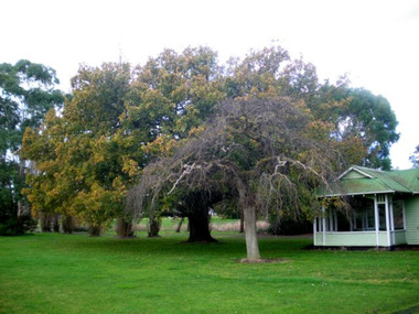
Queen Victoria's Oak Tree
This magnificent English oak tree is located at Tea Tree Lake park in Mortlake. This park was formerly the Botanic Gardens which were developed on what had been swamp land. An artificial lake was created there in 1988 as a Bi-Centenary project.The tree is located adjacent to the historic Montgomery Pavillion and was planted on the occasion of Her Majesty Queen Victoria's birthday on 24th May 1883. An outstanding tree, planted to commemorate a much-revered Queen in an historically-significant Botanic Gardens (now much altered). A very old oak tree planted 1883. queen victoria, mortlake, mortlake botanic gardens, tea tree lake, montgomery pavillion -
 Mortlake and District Historical Society
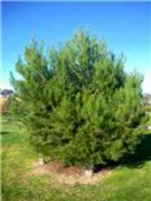
Lone Pine
This pine tree (Allepo Pine, Pinus halepensis) a native of the Gallipoli Peninisula (Gelibolu, Turkey), was grown from a cutting obtained from the War Memorial Canberra and planted in the Mortlake Botanic Gardens in 2002. It replaces the original which grew outside the Mortlake RSL Hall which blew down in a storm c.2000. That tree (Allepo brutius)came from 'the original on Gallipoli' and was planted to commemorate 'fallen comrades' in 'the Jubilee year 1965.' However, two soldiers first brought home pine cones direct from that fateful battlefield. . One was Sgt. Keith McDowell of the 24th Btn. His aunt, Mrs. Emma Gray of Grassmere (Vic.) planted the seeds c. 1928 and four seedlings resulted. One was planted in Wattle Park, Melbourne, one at the Shrine of Remembrance, one at the Soldier's Memorial Hall at The Sisters (c.15 km. south of Mortlake) and one at the Warrnambool Botanic Gardens. The First World War (or 'Great War') and in particular the battle for the Gallipoli Peninsula is of immense national significance. Lone Pine or Plateau 400 was the scene of a major offensive on August 6th 1915. All the trees on the ridge at this point were cut down but one, which was dominated by the 'Lone Pine'. In three days of fighting more than 2,000 Australians lost their lives and seven Victoria Crosses were won. Two Australian soldiers souvenired pine cones - one was brought back to Victoria (see above). Many young men from Mortlake and district volunteered to fight in the Great War and the presence of this tree in our Gardens reminds us all of the local as well as the national sacrifice.l pine tree Small plaque on railing western side. gallipoli, lone pine first world war great war mcdowell, keith -
 Greensborough Historical Society
Book, Banyule City Council, Greensborough War Memorial Sculptures, Leigh Conkie, 2004_
These chainsaw sculptures were carved from the stumps of trees originally planted around the park. The carver was Leigh Conkie. The trees had become diseased and were in danger of falling.Memorial to local people who fought in the various wars of the 20th century. 21 pages, colour illustrationsgreensborough war memorial park, sculptures, ester street, leigh conkie, chainsaw sculptures -
![Postcard set, Banyule City Council, Greensborough War Memorial Park Sculptures, Leigh Conkie [postcards], 2004_](/media/collectors/4f729f5697f83e03086015b8/items/4f72bd6697f83e0308606611/item-media/4f72bd6697f83e0308606613/item-fit-380x285.jpg) Greensborough Historical Society
Greensborough Historical SocietyPostcard set, Banyule City Council, Greensborough War Memorial Park Sculptures, Leigh Conkie [postcards], 2004_
Sculptures created from stumps of trees planted around Greensborough War Memorial park.Memorial to past armed services people from Greensborough District.Set of 12 postcards of chainsaw sculptures in Greensborough War Memorial Park.greensborough war memorial park, sculptures, ester street, leigh conkie, chainsaw sculptures, war memorials -
 Glenelg Shire Council Cultural Collection
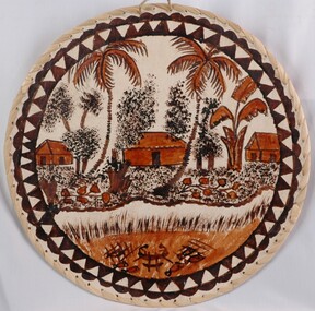
Artwork, other - Tongan - Tapa Cloth, n.d
Circular tapa cloth on masonite backing board, with edges sewn with plant fibre. Scene painted on cloth depicts huts with palm trees by the side of a creek. The creek is edged by a sandy verge and reeds. In the creek are fish traps. The image is painted in black and dark ochre dyes. -
 Glenelg Shire Council Cultural Collection
Photograph, J.T. Somerville, Photographer, Casterton, n.d
Sourced from Casterton Town Hall (former Shire of Glenelg)Black and white photo. Seven Shire of Glenelg Councillors planting a tree in a rural setting.Back: Round, purple, photographer's stamp. -
Glenelg Shire Council Cultural Collection
Photograph, n.d
Sourced from Casterton Town Hall (former Shire of Glenelg)Black and white photo. 7 Shire of Glenelg Councillors planting a tree.Back: Purple photographer's stamp -
Glenelg Shire Council Cultural Collection
Photograph - Photograph - Tree Planting, n.d
Sourced from Casterton Town Hall (Former Shire of Glenelg)Black and white photo. Five Shire of Glenelg Councillors, planting tree in memory of Dame Mary GilmoreBack: 'Crs. J. Little, - Waltham, J. Clarke, D. Mitchell, N. McLeod Secretary planting Dame Mary Gilmore Tree', handwritten in blue biro. Round, purple, photographer's stamp. -
 Dunkeld Museum Inc.
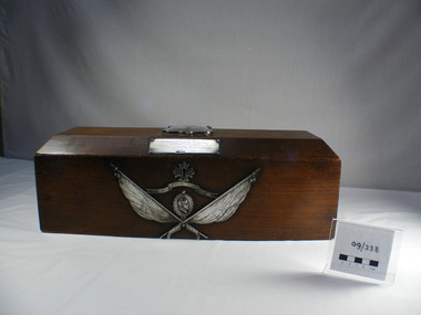
Box, Wooden, Handmade, Wooden Flag Box
This box was made for the Royal Dunkeld School in Scotland to participate in a flag exchange with with the Dunkeld State School No 183 in Victoria, Australia in 1910. It was made from the wood of one of three Larch trees planted in Dunkeld Scotland by the 2nd Duke of Athol from seeds which were brought from the Tyrol. The tree was struck by lightning in 1905 and died over the next few years. It was cut down and some of the timber was used to make the box.This box was sent to the Dunkeld State School from the Royal School of Dunkeld, Scotland and part of a state wide flag exchange in Victoria in 1910. Schools were encouraged to contact schools with a similar name. This box contained a Union Jack which was first flown at the Dunkeld, Victoria school on Empire Day 1910. A box made of Australian Ash was sent to Scotland with an Australian flag enclosed.Timber box made from larch wood. Silver shield on the lid and plaque on the front edge of the lid and crossed flags on the front of the box with a portrait of King George 5th and a banner engraved "God Save the King". Handles on the end are brass lions heads with rings through their mouth. Lock keeper is silver in the form of a Maltese Cross.. The lid has bevelled sides and ends and the interior has strengthening bars in the corners and inside the lid is the provenance of the timber.On top a shield with a bird and a thistle and the letters RDS. Below this a bannet with the words Forward with Honour. On the front bevel of the lid a plaque with "Presented to Dunkeld State School Victoria Australia from Dunkeld Royal H.G. School Scotland 24th may 1910. On the front. Banner with God save the King. Crossed flags representing either the Union Jack or the Scottish Saltair and the Australian Flag and a medallion with the head of King George 5th in relief. -
Glenelg Shire Council Cultural Collection
Photograph - Photograph - Tree Planting, n.d
Sourced from Casterton Town Hall (Former Shire of Glenelg)Black and white photo. Same as 7199. 7 councillors planting a treeBack: Purple photographer's stamp -
Glenelg Shire Council Cultural Collection
Photograph - Photograph - Tree Planting, n.d
Sourced from Casterton Town Hall (former Shire of Glenelg)Black and white photo. Same as 7253. Black and white photo. Five Shire of Glenelg Councillors, planting tree in memory of Dame Mary GilmoreBack: Round, purple, photographer's stamp. -
Glenelg Shire Council Cultural Collection
Photograph - Photograph - Tree planting, J.T. Somerville, Photographer, Casterton, n.d
Sourced from Casterton Town Hall (former Shire of Glenelg)Black and white photo. Same as 7253, 7254. Black and white photo. Five Shire of Glenelg Councillors, planting tree in memory of Dame Mary Gilmore.Back: Round, purple, photographer's stamp.