Showing 427 items
matching topography
-
 Kew Historical Society Inc
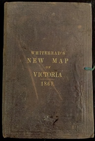
Map, Whitehead's Map of Victoria, With Alphabetical Key, 1869, 1869
When E. Whitehead's New Map of Victoria was released in 1869, an advertisement in the Bendigo Advertiser (16 July 1869) noted that: "This beautifully engraved Map has been revised and brought down to the present time; and, with the Alphabetical Key, is the most complete and the cheapest Map ever published; Price, 6d plain; 1s colored; 2s 6d in case; on linen, post free, 2d extra. E.. WHITEHEAD and CO, Publishers, 67 Collins-street east." The following year, 1870, Whitehead's promoted the edition in the Portland Guardian and Normanby General Advertiser (3 January 1870), advising that: "WHITEHEAD'S NEW MAP OF VICTORIA, 1869 ... is corrected to the latest date, and around is arranged an Alphabetical Key, with Post Towns and Money Order Olffices marked. The Map being divided into squares and numbered, by reference to the Key any place can be found immediately. Price Is beautifully colored, or mounted on linen in case, 2s 6d. Post free, 2d extra, in Victoria. B. Whitehead and C0., Puolishers, 67 Collins-street East, Melbourne". In the same edition of the Portland Advertiser, they also promoted their business generally, saying: "E WHITEHEAD and Co., Stationers, Engravers, Lithographers, 67 Collins street East, execute every description of Lithographic PRINTING, BILL-HEADS. NOTE Headings. Business Dies Engraved and Embossed on Envelopes &c. ARMS, MONOGRAMS, AND CRESTS Engraved and Embossed in Colour, superior to any other house in the Colony. Specimens, post free, 2d. Lithographers, &c, to H.R.H. the Duke of Edinburgh, and Die-inkers and Embossers to His Excellency Sir J. H. T. Manners-Sutton, K C.B. Orders executed for the Trade". Whitehead’s New Map of Victoria 1869 is is an important record of region created towards the end of the Victorian Gold Rush (1851-1869). In addition to its historical significance, this is a rare map, of which the only known copies in Australian public collections are those held at the National Library of Australia, the State Library of Victoria, State Library of New South Wales and the University of Queensland Library.Map of Victoria with gold mining areas, notes on topography, transport routes. Relief shown by hachures. List of towns with distance from Melbourne in map margin. [Melbourne] : Printed & Published by ... E Whitehead & Co ... 67 Collins Street East, 1869 1 map : col., mounted on linen ; 38.4 x 55.4 cm, folded to 18 x 12 cm.Cover "WHITEHEAD'S NEW MAP OF VICTORIA 1869"maps - victoria - 1860s, e whitehead's new map of victoria 1869, whitehead's map of victoria with alphabetical key 1869, cartography, gold rush -
 Lakes Entrance Historical Society
Book, Henderson Kent, The Buchan Experience, 1985
Discovery description of formation history since discovery by Frank Moon description of five caves, Royal, Fairy, Shades of Death, Murrindal and Lilly Pilly, tours of caves, flora and fauna at Buchan Victoria.topography -
Lakes Entrance Historical Society
Book, Haldane Robert, Caving by Frank Moon, 2007
A short history of the Buchan Caves and Frank Moon's involvement in exploration, discovery and promotion of the various caves as a tourist destination. Written to celebrate the centenary of the discovery of the Fairy Caves.topography -
 Lakes Entrance Historical Society
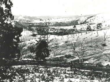
Photograph - Buchan Victoria, Buchan Victoria 1925, 1910 c
Black and white photograph of a snow scene with ringbarked trees in foreground at Buchan Victoriatopography -
 Lakes Entrance Historical Society
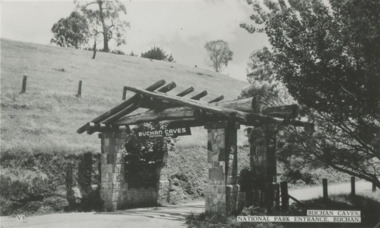
Postcard - Buchan Caves, Victoria, 1940 c
Message on the back from Jean Grant to Myrtle Fish nee Grant. Sent to Myrtle Fish nee Grant by her neice Jean Russ nee Grant possibly Jean's honeymoon 1950 cBlack and white postcard of entrance to Buchan Caves, bare hill on left and bush on right Buchan VictoriaBuchan Caves National Park Entrance Buchantopography -
 Vision Australia
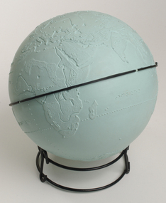
Model - Object, Tactile globe, 1950-1965 approx
Used to teach geographical information, this tactile globe was most likely produced by the RNIB and used at the RVIB Burwood School. Equator is raised and marked in black rubber. Topography land masses and meridians are tactically represented, and includes place names in Braille. A different shade of green is used to represent land masses, and major rivers are shown as well.Green plastic tactile globe with metal stand.Variouseducation aids and devices, rvib burwood school -
 Lakes Entrance Historical Society
Photograph, Todd, Della, 1945c
Black and white photograph of the footbridge over Cunninghame Arm. It shows the scrub covered sand dunes of the south shore in the foreground, footbridge in background. Lakes Entrance Victoria waterfront, topography -
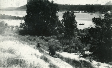 Lakes Entrance Historical Society
Photograph - Township, 1910c
One other copyBlack and white photograph of the township, taken from the hummocks. It shows a person sitting under a black umbrella on a sand hill in the foreground, Cunninghame Arm, two persons in rowboat on water, buildings along Esplanade, Kalimna Heights in background. Lakes Entrance Victoriatopography, waterways -
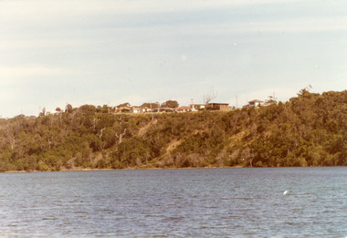 Lakes Entrance Historical Society
Photograph - Kalimna, Fraser Nancy, 1980c
Colour photograph of private residences on the Kalimna escarpment. It shows houses above a timbered cliff at the northern shore of the North Arm of the lake, bare areas on cliff side indicating recent land slide. Lakes Entrance VictoriaHouses Seaview Parade Kalimna North Arm Lakes Entrance (on back) topography, waterways -
 Lakes Entrance Historical Society
Photograph, 1920c
Black and white photograph of Hazel Walk and Tea Rooms at Kalimna. It shows bush track through natural vegetation leading to rustic weather board with canvas awning on the veranda side of tea rooms. Lakes Entrance VictoriaHazel Walk and Tearooms, Lakes Entrance topography, restaurant -
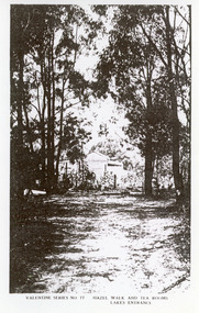
 Lakes Entrance Historical Society
Photograph, 1950c
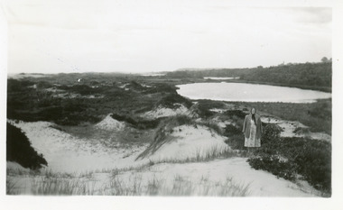
Also enlargement 15x25cmBlack and white photograph of the Warm Holes, from the sand hummocks looking west. The Warm Holes are the remnant of Reeves River, the original waterway from the Gippsland lakes to the natural entrance. Lady with shawl in foreground. Lakes Entrance Victoria waterways, topography -
Lakes Entrance Historical Society
Book, Blake L J, Place Names of Victoria, 1977
An alphabetical list of some of the place names of Victoria with approximate location, and explanation of the name and date of naming. List of references.township, topography -
Lakes Entrance Historical Society
Book, Lavell Leona and Roach Zillah, Rock Hunting in the Cave country, 1980c
Short descriptive stories of rock hunting trips in the Buchan area Victoria naming different gemstones to be found in the district and where to find them. Amusing pen and ink drawings by Z Roach thoroughoutcollections, topography -
 Lakes Entrance Historical Society
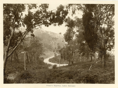
Postcard - Princes Highway Kalimna, 1920c
Sepia toned large format postcard of a bend in the Princes Highway at Kalimna. It shows a bracken covered hill in foreground, some larger trees, steep roadside cutting and post and rail fence at the edge of the road. Picture shows fog rising through trees. Lakes Entrance VictoriaPrinces Highway Lakes Entrance roads and streets, topography -
 Lakes Entrance Historical Society
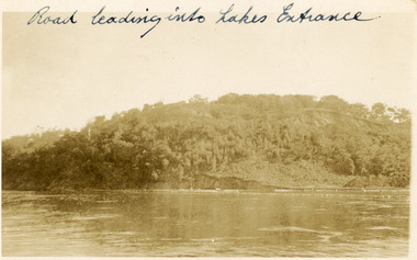
Postcard, 1910c
Faded black and white postcard of Jemmys Point, showing the tree covered hill, road cutting and lake in the foreground. Lakes Entrance VictoriaRoad leading into Lakes Entranceroads and streets, topography -
Lakes Entrance Historical Society
Photograph, 1900c
This photograph has been archivedBlack and white photograph of the township, showing the township along Esplanade, Cunninghame Arm taken from the signal station at New Works. A very clear view of rear of Boole Poole School, later used as office, Pilot's residence and Harbour Engineer's residence, Carpenter's residence, and wooden boardwalk. Lakes Entrance Victoriawaterways, topography -
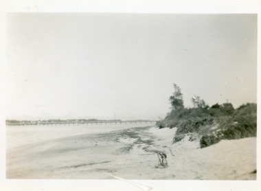
 Lakes Entrance Historical Society
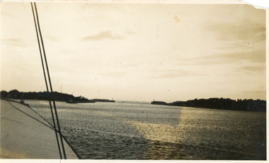
Photograph, 1920c
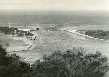
Black and white photograph showing long range view of entrance, piers and dunes from a boat in the main channel, at Lakes Entrance, Victoria.waterways, topography -
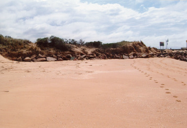 Lakes Entrance Historical Society
Photograph - Beaches, 2009
Date made January 2009Colour photograph showing western side of western pier. Rocks extend from end of pier along base of sand dunes, some vegetation on dunes. Signs and lights on piers. Lakes Entrance Victoria topography, beaches -
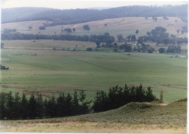 Lakes Entrance Historical Society
Photograph - Sarsfield Flats, Tambo Shire, 1994 c
Also second identical copyColour photograph of Sarsfield Flats. Distant view of cattle grazing and farm buildings, foothills in background, and glimpse of mountains. Pine trees in the foreground. Bruthen Victoriaagriculture, topography -
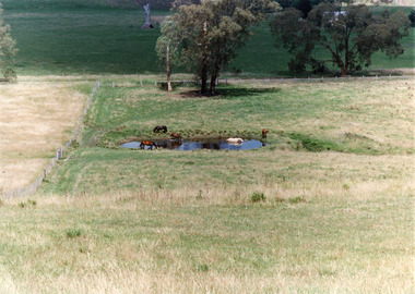 Lakes Entrance Historical Society
Photograph, Tambo Shire, 1994 c
Also second identical copyColour photograph of a rural view near Buchan, shows five horses in and around a dam, farming building in distance glimpsed through trees. Bruthen Victoria topography, agriculture -
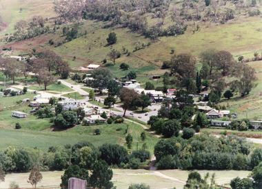 Lakes Entrance Historical Society
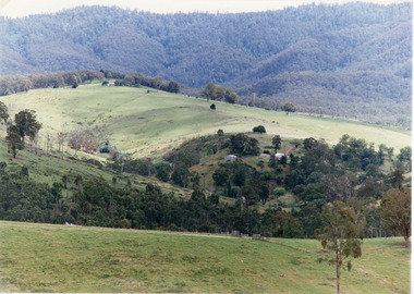
Photograph - Buchan, Tambo Shire, 1994 c
Also second identical copyColour photograph of the township of Buchan, taken from a high point above the town which is situated in a valley with hills rising on all sides. Buchan Victoriatownship, topography -
 Lakes Entrance Historical Society
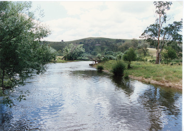
Photograph - Buchan River, Tambo Shire, 1994 c
Colour photograph of the Buchan river, showing stream flowing between low banks, hills rising in distance. Buchan Victoria topography, waterways -
 Lakes Entrance Historical Society
Photograph, Tambo Shire, 1994
Also second similar copyColour photograph taken at The Basin, showing hilly farmland, dense forest on ranges in distance. Buchan Victoriatopography, vegetation -
 Lakes Entrance Historical Society
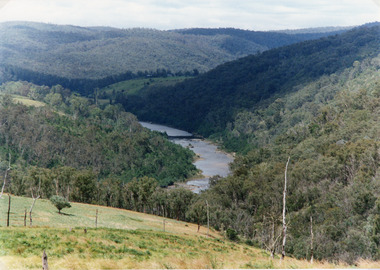
Photograph - Snowy River, Tambo Shire, 1994
Also second identical copyColour photograph of the Snowy River near The Basin, showing a river flowing between rocky banks, densely forested hills rising on both sides and into the far distance. Buchan Victoria topography, waterways -
 Lakes Entrance Historical Society
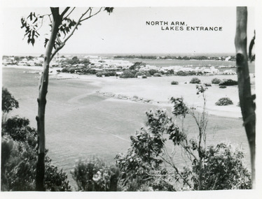
Postcard - North Arm Lakes Entrance, 1945c
Photo taken soon after extensive dredging operations when tons of sand were dumped on low lying land at western end of town.Black and white small format postcard of the North Arm. It shows the township between North Arm and Cunninghame Arm. Lakes Entrance VictoriaNorth Arm Lakes Entrancewaterways, topography -
 Lakes Entrance Historical Society
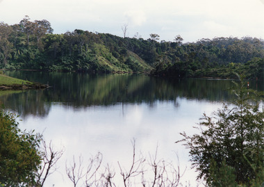
Photograph - North Arm, Tambo Shire, 1990c
Second copy image identical 20.5 x 28.5Colour photograph of a bay in the North Arm. It shows the calm waters of the lake surrounded by steep wooded banks, a grassy point with remains of fence or jetty. Reflections of surrounding vegetation in water. Lakes Entrance Victoria waterways, topography -
 Lakes Entrance Historical Society
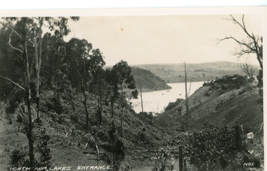
Postcard - North Arm, Valentine Series, 1920c
No. 1 from Valentine Series of small postcardsBlack and white postcard showing lower reach of North Arm, and gully. Vegetation has been removed from both sides of gully. Lakes Entrance VictoriaNorth Arm Lakes Entrance topography, waterways -
 Lakes Entrance Historical Society
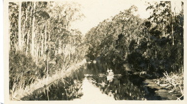
Photograph - North Arm, 1926c
Black and white photograph showing upper reaches of North Arm. Small rowing boat with several people standing in boat. Reflection of vegetation on water. Lakes Entrance Victoriatopography, waterways -
 Lakes Entrance Historical Society
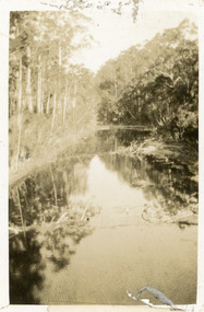
Photograph - North Arm, 1924
Black and white small format photograph showing upper reaches of North Arm. Reflections of vegetation on water. Lakes Entrance Victoriatopography, waterways -
 Lakes Entrance Historical Society
Postcard - The Entrance, 1940c
Black and white small format postcard of the man-made entrance to the Gippsland Lakes taken from Jemmys Point. It also shows the rock groynes at Bullock Island and entrance to Cunninghame Arm. Lakes Entrance Victoriawaterways, topography