Showing 147 items
matching 17 construction
-
 Glen Eira Historical Society
Letter - O’Neill College, Nagle Avenue, 2, Elsternwick
2 articles related to O’Neill College. Photocopy of advertising leaflet for the auction of house- blocks, on the O’Neill College Estate, Elsternwick Auction held 08/04/1922. Copies of 4 letters dated 17/07/1936 to 12/04/1937 from the Victorian Public Health Dept. to the Mother Superior, O’Neill College, regarding alterations to the college buildings.o’ neill college estate, elsternwick, burke t. m., subdivisions, railway crescent, nagle avenue, denver court, robinson c.h., gardenvale railway station, presentation novitiate, auctions, catholic schools, convents, nuns, colleges, school houses, building construction, building permits, public health department, o'neill college, o'neill college estate, elsternwick railway stations, brentani avenue, caulfield city council -
 Eltham District Historical Society Inc
Photograph, Tess Justine (Nillumbik Shire Council), Construction work on replacement of Murray's Bridge over the Diamond Creek, Eltham North, 31 Mar 2022
Construction work on replacement of Murray's Bridge over the Diamond Creek on the Diamond Creek Trail Mary (Sweeney) Murray and John Wright Murray selected 80 acres, Lot C Section 16 and Lot 5 Section 17 Parish of Nillumbik, under an occupation license in 1866. John died in 1867 and freehold was granted to his son John in 1873. The farm was known as ‘Laurel Hill’. John Junior was an Eltham Shire councillor and sometime president from 1887 up until 1897. He added Lot A Section 16 to the farm in ca1888. John and his younger brother James arranged to rent/purchase Lot B Section 17, across Diamond Creek to the west, in ca1900. It appears that John and James farmed separately for a few years, with a new homestead built for James ad family on the high point of Lot B Section 17 in ca1910. John sold off Lot 5 Section 17 in 1912. When John died in 1912 James took over the land on both sides of the Diamond Creek. The old homestead on the west side of the Creek disappeared. A farm bridge over Diamond Creek from this period may have been located close to the northern boundary of the farm. John Langlands, owner of the farm known as ‘Ihurst’ on the west side of Diamond Creek to the south of the Murray’s land, died in 1907. In 1909 his land was then subdivided into 100 lots to become the ‘Glen Park Estate’. Other similar subdivisions of nineteenth century farms around Eltham in this period included the ‘Franktonia (or Beard’s) Estate’ to the northeast and ‘Bonsack’s Estate’ between Eltham and Greensborough. Soon after the opening of the railway extension line from Eltham to Hurstbridge in 1912, Glen Park and nearby residents including James Murray agitated for a railway station or siding to be located half-way between Eltham and Hurstbridge, so that the Glen Park residents who used the railway daily did not have to walk into the Eltham or Hurstbridge stations. Some believed Coleman’s Corner (opposite Edendale Farm) was an appropriate spot for the platform. James Murray was among those who thought the railway should be located on his land, closer to half-way between Eltham and Hurstbridge stations. The Railways Commissioners warned that the locals would have to fund these works themselves. The Glen Park Estate residents initially had difficulty accessing Eltham by road, with only an old low-level bridge over Diamond Creek at the south end of their estate. A new timber trestle bridge across the creek, now on Wattletree Road, was opened in 1915. Road access to the north was gained in 1927 when the new Murray’s Road, which crossed the Murray’s land, was built. Residents continued to agitate for a Glen Park station. By 1926 the Railways Commissioners’ preferred site was on the Murray’s land. They arranged an estimate of cost of a full-length platform. The estimate was too much for the locals, who in 1928 argued unsuccessfully for a shorter and hence cheaper platform. By 1929 Murray had agreed to donate the land, but the locals would still have to fund the works. Murray decided, unilaterally it would appear, to commence work on a timber trestle road bridge over Diamond Creek to link the new Murray Road to the proposed station. Late in 1929 he stopped work on the bridge, for reasons unknown, but started work again and completed the bridge in 1931. There is no further newspaper evidence of the campaign for the Glen Park station until 1939, when Murray and another local, Mr Maxwell, met the Railways Commissioner. The Glen Park locale now included 45 homes on the west side of the creek and 20 on the Eltham side. Most of the residents used the train every day. The Commissioner remained adamant that only a full-length platform could be built for safety reasons. It appears the campaign dissolved at this point. The increasing move to cars may have had an impact. There is no evidence of Murray’s bridge ever being connected to Murray’s Road, or of it having wide use for any purpose by locals. James Murray died in 1947 and the farm was taken over by his son James (Jim). Jim started to sell off parts of the farm in the 1980s, retaining a few acres around the ca1910 homestead and building a new house there. Recreation reserves were established along the creek. In ca1990 Murray’s bridge was renovated with steel girders as part of a bike/pedestrian path in the reserve. The old farmhouse was demolished in ca2014. Born digital image (5)diamond creek (creek), diamond creek trail, murrays bridge, ‘laurel hill’, john wright murray, mary (sweeney) murra, john murray jnr, james murray, john langlands, ‘ihurst’, ‘glen park estate’, beard's estate, franktonia, bonsack's estate, glen park estate, glen park railway station -
 Eltham District Historical Society Inc
Document, Russell Yeoman, Tour of Historic Buildings and Locations, 1978
Self guided heritage tour information produced by the Shire of Eltham Historical Society for 1978 Eltham Community Festival of 36 locations each numbered on accompanying map. Locations and detail provided current to 1978: 1. ELTHAM SHOPPING CENTRE Whilst very little remains in the centre of historical importance, this area has interest as the "village" which developed over many years following the opening of the railway from Melbourne in 1902. Previously the shopping centre had been spread out over a long length of Main Road to the south. Shops have been continuously demolished or remodelled and the majority of buildings date from the 1950's or later. The recently erected Post Office replaced the "old" Post Office opened on the same site only in 1958. 2. WOOLWORTHS ELTHAM VILLAGE Part of the site of this modern shopping development was occupied by the former Eltham Shire Offices and Hall. The hall was paid for by public subscription whilst the Council raised a loan for the offices. The combined building was opened in 1941. It served as office and Council meeting place until 1965 and as the hall until its demolition in 1970. 3. ELTHAM WAR MEMORIAL The complex of buildings adjoining the present Shire Offices were financed by public subscription as a Memorial following World War II. Their construction and for many years their operation was organised by the now disbanded Eltham War Memorial Committee. The original buildings were the; Infant Welfare Centre, Children’s Library (now War Memorial Hall and Dental Clinic) and Kindergarten. In later years the Elderly Citizens Club was built at the rear. 4. ELTHAM SHIRE OFFICES These offices were opened in 1965 and extended in 1971 to provide additional office accommodation and the Eltham Library. They represent the last of a long line of offices and meeting places of the Eltham Shire Council and its predecessor the Eltham District Road Board. The building occupies the former site of Shillinglaw Cottage. The three tall cypress trees which stood in front of the Cottage have been retained as a feature of the office surrounds. 5. OUR LADY'S CHURCH AND SCHOOL The Catholic Church and School complex opposite the Shires Offices shows a number of stages in the development of Eltham township. The recently constructed church adjoins its predecessor (now the parish centre). Many years ago the Catholic Church was located opposite Wingrove Park and the present central site follows the northerly drift of the township. 6. SHILLINGLAW COTTAGE The Cottage was built in 1859 by George Stebbing, a local builder who was responsible for a number of other prominent buildings in the area. Its removal from the site of the Shire Offices and re-erection on the present site was financed by public subscription. It is built of handmade bricks laid in Flemish Bond with an unusual design featuring burnt "leader" bricks over the whole facade. The Cottage is occupied by Eltham Fleececrafts and will be open during the Festival and at other times during weekends. It is classified by the National Trust. 7. RAILWAY BRIDGE The timber trestle bridge over the Diamond Creek was built in 1901. Whilst all of its timbers have been replaced at various times over the years the only change to its character has been the addition of pylons and wiring for electric trains in 1923. It is one of very few similar bridges remaining in the metropolitan area. In 1976 a proposal to replace the bridge with an earth embankment and large culvert pipes was abandoned following community protests. The bridge, however, remains under threat because of the necessity for future deuplication of the railway line. 8. ELTHAM CENTPAL PARK The area between the railway and the creek has for many years been used as a park which included Eltham' s main football oval. The access road, Panther Place is named after Eltham's team playing in the Diamond Valley League. In recent years a large area extending to Bridge Street and locally known as the Town Park has been landscaped and added to the area. The excellent blending of the park with the natural landscape of the creek valley has earned a National Trust Landscape Classification. 9. OLD BAKERY On the southern corner of York Street and Main Road is an old house with a shop front which was for many years the local baker's shop. The brick bakery at the rear is of somewhat later vintage than the house. 10. BRIDGE STREET CUTTING Before reconstruction of Main Road this intersection had deep cutting embankments on all four corners, forming a distinctive feature of the entrance to Eltham. Roadworks and private development have levelled the land on the low side of the road. A memorial to the Eltham soldiers of World War I which was located at the north-western corner is now situated at the Eltham R.S.L. 11. HILLTOP MILK BAR For many years this was the site of the Eltham Post Office under the control of the Hunniford family and later their descendants the Burgoynes. It was transferred to this site in 1855, although at that time the building apparently fronted Bridge Str e et. The site contained Eltham's first telephone exchange. The post office was relocated in 1954 but the shop was operated until recently by the Burgoyne family who still own the surrounding land. 12. UNITING CHURCH and former C.B.A. BANK The former Methodist Church was built in 1880 by George Stebbing. The Sunday School extension was built in 1929 and there have been more recent extensions. The adjoining opportunity shop was built as a bank in 1874 and purchased by the Methodist Church in 1954. 13. R.S.L. HALL, TELEPHONE EXCHANGE These relatively recent buildings occupy the site of a row of shops forming part of the early ribbon of business development along Main Road. In front of the R.S.L. building is the World War I Memorial relocated from the corner of Bridge Street and Main Road. 14. ELTHAM COMMUNITY CENTRE Australia's first mudbrick "community building" was opened in April this year. Part of the site of the building was purchased in 1856 by Henry Dendy (of Brighton fame). At the rear of the land near the creek was a steam flour mill whilst Dendy's house was at the Main Road frontage of the land. His purchase totalled about 2 Ha (5 acres) and included land on the opposite side of Maria Street (Main Road). Dendy became a prominent member of the Eltham community and served one term as President of the Eltham District Road Board. In 1867 Dendy sold his land and business to William Ford of Malmsbury and shifted to Walhalla. The avenue of trees leading past the Community Centre to the creek may well have bordered the track to the mill. 15. ELTHAM HOTEL The original part of this hotel was built in 1927 following the burning of the former Watson's Eltham Hotel on the same site. The car park on the opposite side of Main Road was also the site of a hotel variously known over the years as; the Fountain of Friendship, the Fountain and the Evelyn Arms. As the Fountain of Friendship it was the first meeting place of the Eltham District Road Board in 1856. 16. ST. MARGARET'S CHURCH, PITT STREET In 1860 Henry Dendy was appointed Chairman of a committee to establish a church of England in Eltham. He donated part of his land in Pitt Street and in 1861 the church was opened. It was built by George Stebbing and remains in a well preserved state today. Th adjoining old vicarage is now named Dendy Hou se. A new mudbrick church hall is under construction on the site. The church and Dendy House are now listed on the Register of Historic Buildings. 17. NO. 86 PITT STREET Cottage built by George Stebbing and believed to be his home for some years in the 1850s. 18. LIVING AND LEARNING CENTRE The house was built in the 1850s with the kitchen at the front being added about 40 years later. By the creek below the house a number of early Eltham industries were located. These included a tannery and a brewery. 19. ELTHAM COURT HOUSE A Court of Petty Sessions was established in Eltham in 1858 and the present building dates from 1860. It is the oldest public building remaining in Eltham. In its early days the building was used as the meeting place and office of the Eltham District Road Board and as an overflow classroom for the local school. The Court House has been classified by the National Trust. The citation states that it is an example of the simple form of early brick Court House with gabled roof and porch. 20. LANDS DEPARTMENT OFFICE This building is the former police station and is probably of about the same age as the Court House. The lockup at the rear has been demolished but the old stables remain as garages. A licence was first granted for a police station at Eltham in 1856. 21. JARROLD COTTAGE The old Cottage opposite Dalton Street was formerly owned by the Jarrold family. Early records indicate that this was the building leased from the Jarrolds as a temporary police station prior to construction of the building on the corner of Brougham Street. The small building on the corner of the property was used as a boot repairer's shop. The elevated studio at the rear is a more recent construction by the present owners. 22. STATE SCHOOL RESIDENCE Erected in 1891 23. WINGROVE COTTAGE This building fills an important place in the history of Eltham and is now used as a medical clinic. It was built in 1858 for Charles S. Wingrove who was Secretary to the Eltham District Road Board and Shire Council from 1858 to 1904. During part of this period he was also Shire Engineer and was Secretary to the Heidelberg Road Board. The house was used as the office of the Board and Council for many years. Wingrove is buried in the cemetery at St. Helena. 24. WINGROVE PARK The parkland opposite Wingrove Cottage has been named after Charles Wingrove. The old Manna Gums are an outstanding feature of the park. 25. ELTHAM FRI.MARY SCHOOL NO. 209 The school first opened in the slab building in 1855 and operated from the present site since 1857. The oldest part of the present school is the stone building erected in 1876. The first school teacher, David Clark remained at the school until 1888. This school is the government township and has always been known as the Eltham School. An earlier school (no.371) known as Little Eltham School operated in Swan Street from 1853 to 1872. 26. "SHOESTRING" This house was built for school teacher David Clark. It has been extensively extended in recent years but the extensions do not detract from the character of the older part of the building. 27. ELTHAM CEMETERY The cemetery contains the graves of many of the district's pioneers . 28. MONTSALVAT This unique complex of buildings was commenced in 1935 by the late Justus Jorgensen and its development has extended over many years. Montsalvat has exerted a significant impact on Eltham The earth and stone construction of many of the buildings has influenced local architecture to a great extent and it has served as a "nerve centre" of the local artistic community. Montsalvat is open to the public for a small charge. 29. MAIN ROAD BRIDGE This location has been the main crossing of Diamond Creek since the earliest days of settlement. The present concrete bridge was erected in 1925 .and was preceded by a number of timber bridges. 30. ELTHAM LOWER PARK This park, being an unusually large flat area for Eltham, was originally the local racecourse. Horse races were held here from 1855 and the area was gazetted as a reserve for a racecourse and recreation reserve in 1857. The park is well known as a venue for school "bird days" and more recently as the site of the Diamond Valley Railway. This miniature railway features scale models of modern and old locomotives and rolling stock and has operated on this site since 1961 . Before that the railway operated at Chelsworth Park, Ivanhoe. 31. FALKINER HOUSE Frederick Falkiner was one of the earliest settlers in the Eltham township area and occupied a substantial leasehold prior to the first land sales. Early records show that Falkiner was the subject of a number of complaints from his neighbours but he has nevertheless been considered a prominent enough citizen to have a street named for him. This house was the home of Evelyn (Ely) Falkiner a member of Frederick's family. 32. WEST HOUSE Behind the large house on the hill is an early house built by the West family. This was relocated from a site near the front of the land by the present owner Mr. Fabbro. 33. FALKINER HOUSE This very old house is believed to have been the home of Frederick and may have been Eltham's first post office. Falkiner was the first post master for a short period. in 1854/55. 34. WITHERS HOUSE This house was the home of famous artist Walter Withers who shifted here from Heidelberg in 1903. 35. ELTHAM HIGH SCHOOL This school celebrated its jubilee this year, having commenced as the Eltham Higher Elementary School 50 years ago. 36. DIAMOND CREEK FOOTWAY If returning from the High School to the town centre the footpath by the bank of the Diamond Creek provides a pleasant route to finish your walk. The creek is a major tributary of the Yarra River. Together with its own major tributaries Arthurs Creek and Running Creek it commences on the southern slopes of the Dividing Range at Kinglake. It gives the name Diamond Valley to an area extending well beyond its actual drainage catchment.Recognition of the significance of various landmarks to the history of the Eltham community as of 1978‘shoestring’, 1978, bridge street cutting, burgoyne store, c.b.a. bank, diamond creek trail, eltham cemetery, eltham central park, eltham community centre, eltham community festival, eltham court house, eltham festival, eltham high school, eltham hotel, eltham lower park, eltham primary school, eltham railway trestle bridge, eltham shire offices, eltham shopping centre, eltham state school no. 209, eltham village, eltham war memorial, falkiner house, heritage trail, hilltop milk bar, jarrold cottage, lands department office, living, living and learning centre, main road bridge, montsalvat, old bakery, our eltham artistic recollections, our lady help of christian’s church, our lady help of christian’s primary school, pitt street, post office, r.s.l. hall, shillinglaw cottage, st margaret’s church, state school residence, stebbing cottage, telephone exchange, uniting church, west house, wingrove cottage, wingrove park, withers house, woolworths -
 Eltham District Historical Society Inc
Slide - Photograph, Grace Mitchell, Roadworks at intersection of Main Road and Mount Pleasant Road, Eltham, c.1962
View from Grace Mitchell's shop at the corner of Mount Pleasant Road and Main Road. Grace Mitchell was probably best known for her Eltham shop at the corner of Mt Pleasant Road and Main Road. Grace's memories covered many local identities who were patrons of her shop between 1954 and 1971. From the elevated position of her shop and home Grace was able to view a varied passing parade of Eltham events from ERSILAC, Easter and Eltham Festival parades passing on their way to Eltham Lower Park, circuses in Wingrove Park (then Bremner’s Reserve), roadworks and other happenings. Bremner's Reserve was renamed Wingrove Park c.1970 35mm Kodak 5052 TMX Black and White transparency, 1 strip, 6 frames Black and white print 17 x 25.4 cmbremner's flat, eltham, golden fleece service station, main road, mount pleasant road, road construction, wingrove park -
 Eltham District Historical Society Inc
Photograph, A walk through the cemetery at Kangaroo Ground, Diana Bassett-Smith, 1 October 2001, 2001
We wanted to see how the construction of a rotunda at the cemetery was progressing and were surprised and pleased to see it finished. A new green plastic water tank was atop a stand not far away. A brief collection of reminiscences by Diana Bassett-Smith of locals who are buried at Kangaroo Ground Cemetery along with 17 photographs following a visit on 1 October 2001.Colour photograph print1983 bushfire, air vice marshall wackett, ambrose erswell, barry roach-pierson, bill pelling, billy roach-pierson, birrarung, bourchiers road, ca 13, crichton, david grant, diamond street, diana bassett-smith, donald grant, donaldson road, dorrie bourchier, duff, early settlers, elizabeth cottee, ewan cameron mp, grey house, helen kohn, isabella grant (nee stevenson), jack bourchier, james balfour, james wilson, jean stewart, jessie bull (nee haughton), jimmy cook, jocelyn, joseph stevenson, judge book village, judith furphy, kangaroo ground cemetery, kay roach-pierson, keith jocelyn, kraft foods, lacey, lloyd stuart, louise grant (nee gordon), mardi crocker, marion erswell, ned haughton, nursery, pam chevallier, passiona, peter bassett-smith, pigeon bank, rath, ricketson, robinson, ruth boyd, steven crawford baes, tintagell, tosch, vera jackson, wackett trainer, watershed jackson, willandra poultry farm, zac crocker -
 Eltham District Historical Society Inc
Photograph, A walk through the cemetery at Kangaroo Ground, Diana Bassett-Smith, 1 October 2001, 2001
The Kangaroo Ground Cemetery celebrated its 150th anniversary in 2001. Celebrations included the opening of a new rotunda on the 26 October 2001. This photo is a part of a brief collection of reminiscences by Diana Bassett-Smith of locals who are buried at Kangaroo Ground Cemetery along with 17 photographs following a visit on 1 October 2001. "We wanted to see how the construction of a rotunda at the cemetery was progressing and were surprised and pleased to see it finished. A new green plastic water tank was atop a stand not far away." Colour photograph printkangaroo ground cemetery, rotunda -
 Eltham District Historical Society Inc
Photograph, A walk through the cemetery at Kangaroo Ground, Diana Bassett-Smith, 1 October 2001, 2001
The Kangaroo Ground Cemetery celebrated its 150th anniversary in 2001. Celebrations included the opening of a new rotunda on the 26 October 2001. Ths photo is a part of a brief collection of reminiscences by Diana Bassett-Smith of locals who are buried at Kangaroo Ground Cemetery along with 17 photographs following a visit on 1 October 2001. "We wanted to see how the construction of a rotunda at the cemetery was progressing and were surprised and pleased to see it finished. A new green plastic water tank was atop a stand not far away." Colour photograph printkangaroo ground cemetery, rotunda -
 Eltham District Historical Society Inc
Document - Folder, Cr. John Herbert, Shire President, Eltham Shire, 1894-1906, 1898 to 1917
Cr. John Herbert served three terms as Eltham Shire President A3 photocopy of 3 documents with note at bottom of page - Cr. John Herbert 1. Federal Convention, The Government of Victoria request the honor of the Company of the The President, Eltham Shire & Lady to a Garden Party at Parliament House Melbourne on Friday February 4th 1898 at 3 o'clock. 2. Heidelberg & Eltham Railway Construction Trust, Ticket No. 87, Dinner in celebration of the opening of the Railway to Eltham, will be given in the Marquee on the Station Ground, Eltham on Thursday, 5th June, 190212.30 o'clock, H.J. Price, Secretary 3. Post card addressed to Miss Flora Herbert, "Blair Athol", Nutfield P.O., Victoria, Australia - France 12/12/17 - Dear Floss, Just a card to let you know I have not forgotten you. Tell "Mum" I am quite well, but a bit cold, I remain yours sincerely, Will"Photocopy A3 page; all three items on one page aif, blair athol, councillors, cr. john herbert, eltham railway station, eltham shire council, federal convention, first world war, flora herbert, government of victoria, heidelberg & eltham railway construction trust, invitation, nutfield, opening ceremony, parliament house, postcards, shire president -
 Eltham District Historical Society Inc
Slide, Sherbourne Road overpass, Briar Hill, North Abutment, 17 July 1970, 1970
Construction of new realigned Sherbourne Road railway overpass following realignment construction works for intersection of Sherbourne Road and Para Road.35 mm colour positive transparency Mount - Agfacolor Service (Blue)briar hill, bridge construction, overpass, para road, railway bridge, road construction, sherbourne road -
 Lara RSL Sub Branch
Drivers Licence, Australian Military Forces Army Driving Licence
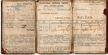
... , Ron enlisted in the CMF and served with 22nd Construction..., Ron enlisted in the CMF and served with 22nd Construction ...Cpl. Ronald Warren Ellis, EM (VX502517) was born in Brunswick in 1927. His family moved to Lara when he was young, and his schooling took place at the Lara State School. After finishing his education, Ron took up employment at Sims Coopers in Corio. Ron was enlisted in the second AIF at Melbourne, and posted to the 3rd Recruit Training Battalion at Greta west of Newcastle, NSW. After 3 months training, he was sent to the Service Corps Training Centre for driver and maintenance training in Ingleburn, south of Sydney. When this course was completed, Ron was posted to the Australian Army Service Corps as a driver motor vehicle with the 2nd AIF. Rons service with the AIF lasted 425 days, when he was then transferred to the Interim Army for a further 309 days. The duration of his service was in NSW. Ron was discharged from the Army in Melbourne on the 4th of May 1948. In 1957, Ron enlisted in the CMF and served with 22nd Construction Squadron for 17 years with the last 5 as a Corporal, and was awarded the Efficiency Medal for long service and good conduct.Brown canvas booklet that is folded into three. Licence gives details of Army number, name, rank and type of vehicle that is able to be driven. Licence has been issued to Private Ronald Warren Ellis on 24/01/1948. No. 258778 Army No. V?SOL517 Rank: Private Name in full: Ellis, Ronald Warren Unit: Transferred to (unit): Having passed the prescribed tests ... authorised to drive... types of ... vehicles within the Commonwealth of Australia and Territories. Signature of Driver: drivers licence, australian military forces, army, private, ellis, ww2, wwii, world war two, second world war -
 Lara RSL Sub Branch
Photo, Harry Grove
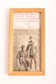
... and served with 22nd Construction Squadron for 17 years with the last..., Ron enlisted in the CMF and served with 22nd Construction ...This photo is from 1917 and is of Private Harry Groves (standing) with his cousin Arthur Whitter (seated). Private Groves was the Uncle of Ron Ellis, who was a Lara Sub-Branch member. Cpl. Ronald Warren Ellis, EM (VX502517) was born in Brunswick in 1927. His family moved to Lara when he was young, and his schooling took place at the Lara State School. After finishing his education, Ron took up employment at Sims Coopers in Corio. Ron was enlisted in the second AIF at Melbourne, and posted to the 3rd Recruit Training Battalion at Greta west of Newcastle, NSW. After 3 months training, he was sent to the Service Corps Training Centre for driver and maintenance training in Ingleburn, south of Sydney. When this course was completed, Ron was posted to the Australian Army Service Corps as a driver motor vehicle with the 2nd AIF. Rons service with the AIF lasted 425 days, when he was then transferred to the Interim Army for a further 309 days. The duration of his service was in NSW. Ron was discharged from the Army in Melbourne on the 4th of May 1948. In 1957, Ron enlisted in the CMF and served with 22nd Construction Squadron for 17 years with the last 5 as a Corporal, and was awarded the Efficiency Medal for long service and good conduct. This photo represents the connection that Lara RSL members and their family members have to the conflicts that Australia has been involved in over time. Photograph of Harry Grove (standing) with his cousin Arthur Witter (seated) - France 1917. The black and white photo is framed within a wooden frame, and above it is a piece of paper with details about the photo written in red texta. The photo is black and white, and in the bottom right corner in pencil is written: Sincerely Yours, Arthur. The remainder of the text extends under the frame, but looks as though it says: Arthur, France. world war 1, ww1, wwi, photo, family, private, corporal -
Federation University Historical Collection
Document - Document - Syllabus, Education Department, Victoria, Syllabuses, Technical Schools, 1921 and 1924
Syllabuses produced by the Education Department of Victoria. They are for Technical Schools and outline requirements for various subjects. They were produced at the beginning of each year. .1, .2, .3 are for 1921. .4 to .22 are for 1924. .1: Mechanics and Mechanics Applied to Mining (1921) .2: Mechanics and Heat (1921) .3: Graphics (1921) .4: Hydraulics (1924) .5: Civil Engineering (1924) .6: Electrical Technology (1924) .7: Electric Wiring (1924) .8: Sheet Metal Work, Pattern Cutting for Tinsmiths, Galvanized Iron Workers and Sheet Copper Workers (1924) .9: Metal Work (Machine Shop Practice) (1924) .10: Farm Irrigation and Irrigation Engineering .11: Food Analysis .12: Theory of Aircraft Design and Construction (1924) .13: Iron, Steel and Engineering Alloys (Special Course for Aeronautical Engineers) (1924) .14: Civil Engineering (1924) .15: Diploma Students - Iron, Steel and Engineering Alloys (1924) .16: Aerodynamics (1924) .17: Electrical Engineering (1914) .18: Mechanical Drawing, 2nd Year Students - Junior Technical Schools (1924) .19: Mechanical Drawing, 3rd Year Students - Junior Technical Schools or Preparatory Evening Course for Technical School Students (1924) .20: Mathematics (1924) .21: Diploma Courses in Engineering - Electrical, Mechanical, Marine, Civil, Aeronautical (1924) .22: Civil Engineering (1924) 22 items, A5 in size. Some are folded sheets of A4 paper.sylabus, education department, victoria, technical schools, 1921, 1924, mechanic and mechanics applied to mining, mechanis and heat, graphics, hydraulics, civil engineering, electrical technology, electric wiring, sheet metal work, pattern cutting for tinsmiths, galvanised iron workers, sheet copper workers, machine shop practice, farm irrigation, irrigation engineering, food analysis, theory of aircraft design and construction, aeronautical engineers, diploma students, aerodynamics, electrical engineering, mechanical engineering, mechanical drawing, junior technical schools, evening course for technical students, mathematics -
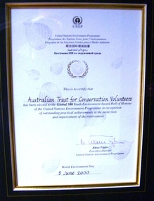 Conservation Volunteers
Award: Honour Roll, United Nations Environment Program (UNEP) - 1 June 2000 - The UNEP announced that the Australian Trust of Conservation Volunteers of Australia (ATCV), has been elected to the prestigious ranks of its Global 500 Roll of Honour for outstanding contributions to the protection of the environment, Award:United Nations Environment Program (UNEP) - 1 June 2000 - UNEP announced today that the ATCV has been elected to the prestigious ranks of its Global 500 Roll of Honour for outstanding contributions to the protection of the environment
THE AUSTRALIAN TRUST OF CONSERVATION VOLUNTEERS, ONE OF 14 INDIVIDUALS AND ORGANIZATIONS, TO RECEIVE UNITED NATIONS ENVIRONMENT AWARD NAIROBI, 1 June 2000 - The United Nations Environment Programme (UNEP) announced today that the Australian Trust of Conservation Volunteers of Australia (ATCV), has been elected to the prestigious ranks of its Global 500 Roll of Honour for outstanding contributions to the protection of the environment. ATCV is one of 14 individuals and organizations to receive this honour in 2000. Founded in 1982, ATCV is a national, not-for-profit community organization, whose mission is to attract and manage a force of volunteers in practical conservation projects for the betterment of the Australian environment. ATCV completes more than 4000 week-long conservation projects in urban, regional and remote areas of Australia each year. Activities range from bush regeneration, tree planting, seed collection, endangered species protection, weed control, flora and fauna surveys, walking trail construction, fencing, environmental monitoring and the protection of world heritage areas. ATCV community participation has resulted in more than 1.8 million trees being planted in 1999, and in more than 7.3 million trees planted over the past 10 years. Community involvement totalled 200,000 project days in 1999 and more than 700,000 days since 1989. To encourage the involvement of young people, ATCV developed and manages the federal government-funded programme Green Corps. Green Corps is a six-month traineeship for 17 to 20 year-olds, which incorporates conservation projects and accredited training. Since 1997, more than 4,000 trainees have completed the Green Corps programme. ATCV is a founding member of the International Conservation Alliance, which brings together organizations working in conservation volunteering, and is a member of the World Conservation Union (IUCN). " The award will be presented in Adelaide, Australia, at the World Environment Day ceremonies on 4 June 2000. World Environment Day, which is celebrated in some 120 countries around the world on 5 June, was established by the United Nations General Assembly in 1972 to focus global attention and action on environmental issues. Some 701 individuals and organizations, in both the adult and youth categories, have been honoured since UNEP launched the Global 500 award in 1987. Among prominent past winners are: French Marine explorer Jacques Cousteau; Sir David Attenborough, producer of environmental television programmes; Gro Harlem Brundtland, former Prime Minister of Norway; Anil Aggarwal, the prominent environmentalist from India; Ken Saro-Wiwa, the environmental and human rights activist from Nigeria who was executed for leading the resistance of the Ogoni People against the pollution of their Delta homeland; the World Wide Fund for Nature (WWF), Jimmy Carter, former President of the United States; Jane Goodall of the United Kingdom whose research on wild chimpanzees and olive baboons provided insight into the lives of non-human primates; and the late Chico Mendes, the Brazilian rubber tapper who was murdered during his fight to save the Amazon forest. To forge global links and to implement ideas, which can contribute to a more sustainable future, a network of all Global 500 laureates has been formed. Information about this unique network can be obtained at http://www.global500.org. The winners of UNEP's Global 500 Roll of Honour are members of a broad and growing environmental movement that is flourishing around the world. They have taken the path that most of us hesitate to take for want of time or caring," says UNEP's Executive Director, Klaus Toepfer. "In honouring the Global 500 laureates, UNEP hopes that others will be inspired by their extraordinary deeds."Certificatecva, conservation volunteers, conservation volunteers australia, conservation volunteers new zealand, colin jackson, better earth, environmental conservation, volunteers, volunteering, corporate volunteering, education – environmental, carbon footprint, climate change, ballarat, safety, training, partnerships, victoria, vic, nsw, queensland, act, australian capital territory, nt, northern territory, western australia, wa, south australia, sa, tasmania, new zealand, california conservation corps, atcv, unep, unep honour roll, united nations environment program -
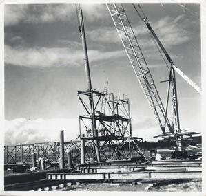 Phillip Island and District Historical Society Inc.
Photographs, Phillip Island 2nd Bridge Construction, 1966 - 1969
22 of a collection of 70 Black & White photographs taken during the construction of the second Phillip Island Bridge from San Remo to Newhaven by Country Roads Board and Shire of Bass. Contractor John Holland & Co. Pty. Ltd.14 Black & White photographs of the construction of the second Phillip Island Bridge in 1966 - 1969. 351-09: Pile driving on Newhaven abutment. 351-10 & 11: Concrete beams. 351-12: Pile driver. 351-13 & 14: Machinery. 351-15: Dismantled section of cylinder. 351-16 & 17: Coffer dam and pier construction. 351-18: Man up on scaffold. 351-19 & 20: Construction work. 351-21: Two workmen and man leaning on section of handrail exposed to weather. 352-22: View of construction work.Descriptions as above on some. Plus the following Numbering: 351-09: CRB NEG 67-274C. 351-10: CRB NEG 67-542. 351-11: CRB NEG 67-654F. 351-12: CRB NEG 66-605. 351-13: CRB NEG 66-601. 351-14: CRB NEG 68-752B. 351-15: CRB NEG 67-936. 351-16: CRB NEG 67-937A. 351-17: CRB NEG 67-937B. 351-18: CRB NEG 67-1156D. 351-19: CRB NEG 67-1156B. 351-20: CRB NEG 66-1026E. 351-21: CRB NEG 67-940. 351-22: CRB NEG 67-1218Bphillip island bridge construction, 2nd phillip island bridge construction, country roads board, shire of bass, sasha stark -
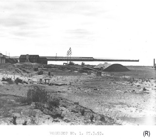 Glenelg Shire Council Cultural Collection
Photograph - Photograph - Portland Harbour Trust - Workshop no. 1, 27.3.53, 1953
Port of Portland Authority archivesFront: WORKSHOP NO. 1. 27.3.53. (lower centre) Back: P.H.T./ Print No. 3/17 Neg. No 148/ Date taken 27.3.53./ SUBJECT./ % (Ink stamp with blue pen and pencil additions, centre)port of portland archives -
Glenelg Shire Council Cultural Collection
Photograph - Photograph - Portland Library, Victoria, 17/12/1998
Photographs of Portland Library - late 1990s to early 2000s, showing activities at the library and construction of additions to the building.Coloured photo. Portland Library, 2 boys at computer.Front: '98 12 17' -
Glenelg Shire Council Cultural Collection
Photograph, Contact prints construction site, 1964
Port of Portland Authority ArchivesFront: 18. 13-3-64 19. 13-3-64 17. 13-3-64 16. 13-3-64 15. 13-3-64 14. 13-3-64 (In white under each print). Back: 226, 193 and 198 in pencilport of portland -
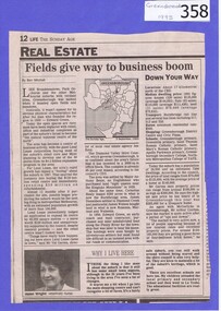 Greensborough Historical Society
Newspaper clipping, Fields give way to business boom, 1993_
Tells some of the story of the settlement of Greensborough and Lend Leases' gradual take over of Greensborough shopping area. In Canberra Times Wednesday 17 November 1993, page 27: Melbourne: Lend Lease Corp Ltd is to undertake a $600 million redevelopment of two suburban Melbourne shopping centres, at Dandenong and Greensborough; to be built in conjunction with Australia's largest retailer; Coles Myer Ltd. The project will create about 2000 jobs; 1000 during construction and 1000 in long-term retail.Has some history of Greensborough and records the average land prices in 1993. A black and white Sunday Age newspaper story. Includes map and photograph of resident.greensborough, lend lease, 1993, land prices -
 Kiewa Valley Historical Society
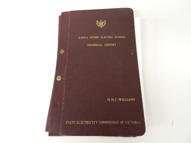
Book- History of SEC at Kiewa x2, Technical History of the Kiewa Hydro Scheme, circa 1960's
... of construction. There are also 17 sketches/plans scattered throughout... photographs of various stages of construction. There are also 17 ...This book of planning and construction details covers the first detailed records the Kiewa Hydro Electricity Scheme of 1919 (ORIGINAL), 1958 (2nd Modified Plan) to the last general plan of 1961. It is an excellent overview of one of Australia's greatest construction projects (along with the Snowy River Hydro Scheme). This book highlights in detail the planning, programming and construction phases throughout the life of the construction from 1919 onwards until the 1960's. There were a few copies made using carbon paper and a type writer on foolscap paper.This book with its Parts A to D, photographs and plans/tables is very significant to the Kiewa Valley region as it details "the bones" of one of Australia's greatest construction projects that was undertaken by Governments that had the foresight and the will to undertake such a costly and environmentally imposing project for the benefit of their states and their country. This project was at a time when financial and security pressures where at a high and fluctuating level. This project was the major contributor to the expansion and diversity of non rural activities within the region. It was directly and indirectly the cause of better transportation avenues, tourism and the lifting of the regions natural facilities to sustain an ever increasing long term and short term population.This large hard (thick cover) book has both front and back sides fastened to the spine by two brass screw on pins. The book title, author/compiler and the commissioning organisation (STATE ELECTRICITY COMMISSION OF VICTORIA) together with the SEC Vic emblem are all embossed in gold script.The spine is also embossed with the title. The book contains 396 pages consisting of the 390 pages which are the duplicate(carbon copy) of the original type written pages and 6 pages of site plans. Sprinkled throughout the book are 36 original photographs of various stages of construction. There are also 17 sketches/plans scattered throughout and 22 tables.Title "KIEWA HYDRO ELECTRICITY SCHEME TECHNICAL HISTORY" author and compiler "H.H.C.WILLIAMS" below this "STATE ELECTRICITY COMMISSION OF VICTORIA"kiewa hydro electricity scheme, victorian state electricity commission, history, proposals, kiewa scheme's plans, book, h.h.c. williams -
 Ringwood and District Historical Society
Photograph, Bridge over Mullum Creek under construction, Oliver Street. 1963
2 photographsWritten on back of photograph, "Bridge over Mullum Creek, Oliver Street. 17/11/1963" -
Alexandra Timber Tramway & Museum
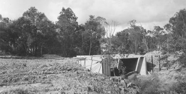
Mr Sapsford, rubicon channel and tram tracks
Photograph of local event .Building of Rubicon power house ( station ) Detail of construction evedent in photoUn replaceable .record of local eventsrubicon photo of channel and tram tracks, put in to feed hydro system .note tree harvest and elevated channel to the right taken by mr sapsford of alexandrarubicon channel and tram tracks -
Alexandra Timber Tramway & Museum
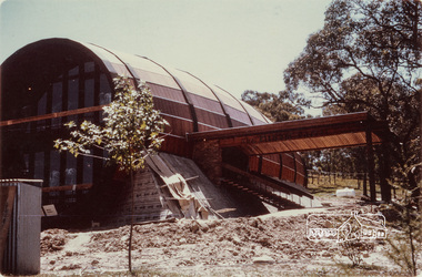
rubicon black and white photo, Mr Sapsford, Rubicon control station A
Mr Sapsford photo taken addmisted the construction of the Rubicon power house ( station ) at Rubicon . With out the likes of this photographer (Sapsford ) we would not have such a great and all incompassing recordUnreplaceable . record of building of Rubicon power houseRubicon control stations A at Rubicon with transformers to the left . Photo taken by Mr Sapsford of Alexandra . In good condRubicon A control station -
 Eltham District Historical Society Inc
Photograph, Bernie Murray, Construction of the Eltham Barrel nearing completion, 17 November 1968, 17 Nov 1968
Digital scan only of print held in private collection.Inscription back 3A-568eltham, eltham barrel, kalbar road, natalie mews -
 Glen Eira Historical Society
Photograph, Beauville Avenue, 17, Murrumbeena, 2001
Originally labelled "Beauville Estate, Established 1936, Still Thriving 65 years on, 10th March 2001", the Beauville Estate Album contains colour photographs of houses in the Estate. They were taken around the time of the Beauville Estate’s 65th Heritage Celebration held on 10/03/2001 and donated to the Caulfield Historical Society shortly afterwards. Photographer unknown.City of Glen Eira’s Heritage Management Plan Vol 2 p79 (this is p84 of the pdf version) – HO12 Beauville Estate and environs, Murrumbeena: The Beauville Historic Area is important at the State level as the first large housing estate undertaken by the AV Jennings Construction Co, later Jennings Group Limited, Victoria’s largest home builder. It is important also as a very early estate development incorporating a range of features other than houses and including made roads, shops and recreation facilities. In this respect it was the forerunner of the comprehensively planned housing estate of the post war era. The estate is distinguished by its aesthetic values, as is the earlier and comparable Hillcrest Estate, which are formed by a combination of restrained diversity in house styles, with the exception of no. 30 in the emerging International style, and by a landscaped garden environment. Colour photograph of the porch of an unpainted variegated brown brick house. The porch features decorative brickwork with arched entrances, lantern light and cast iron gates. murrumbeena, houses, beauville avenue, architectural styles, 1930's, inter war style, a.v. jennings, av jennings, jennings, brick houses, beauville estate, porches, arches, sir albert victor jennings, a v jennings construction co, beauville estate heritage area, glen eira city council, architectural features, jennings group limited, land subdivision, gardens, beauville historic area, brick features, cast iron gates, cast iron lights -
 Glen Eira Historical Society
Photograph, Dalny Road, 5-17 Rear, Murrumbeena, 2001
Originally labelled "Beauville Estate, Established 1936, Still Thriving 65 years on, 10th March 2001", the Beauville Estate Album contains colour photographs of houses in the Estate. They were taken around the time of the Beauville Estate’s 65th Heritage Celebration held on 10/03/2001 and donated to the Caulfield Historical Society shortly afterwards. Photographer unknown. From Glen Eira’s Heritage Management Plan by Andrew Ward (1996) Vol 2 p78: "Beauville Avenue is unusual in that it is terminated in a cul-de-sac (see Section 3.9.2) whilst the design of the estate may well be unique for its time in that the houses back onto 6 tennis courts for public use. St. Patrick's Church, which adjoins the estate is a comparatively recent structure whilst the school has one building erected in 1930 and prior to the release of the Beauville lots." It also notes that St.Patrick's Church and School now run the tennis courts. The Beauville Historic Area is important at the State level as the first large housing estate undertaken by the AV Jennings Construction Co, later Jennings Group Limited, Victoria’s largest home builder. It is important also as a very early estate development incorporating a range of features other than houses and including made roads, shops and recreation facilities. In this respect it was the forerunner of the comprehensively planned housing estate of the post war era. The estate is distinguished by its aesthetic values, as is the earlier and comparable Hillcrest Estate, which are formed by a combination of restrained diversity in house styles, with the exception of no. 30 in the emerging International style, and by a landscaped garden environment. See Significance Statement in Glen Eira’s Heritage Management Plan by Andrew Ward (1996) Vol 2 p.79. Available from https://www.gleneira.vic.gov.au/media/4779/heritage_management_plan_volume_2.pdf (Note see p.84 of pdf)Colour photograph of a playground on the Beauville Estate. murrumbeena, houses, 1930's, a.v. jennings, av jennings, jennings, beauville estate, playgrounds, parks and reserves, sir albert victor jennings, a v jennings construction co, beauville estate heritage area, glen eira city council, jennings group limited, land subdivision, gardens, beauville historic area, st patrick's church, st patrick's school, dalny road -
 Glen Eira Historical Society
Photograph, Dalny Road, 5-17 Rear, Murrumbeena, 2001
Originally labelled "Beauville Estate, Established 1936, Still Thriving 65 years on, 10th March 2001", the Beauville Estate Album contains colour photographs of houses in the Estate. They were taken around the time of the Beauville Estate’s 65th Heritage Celebration held on 10/03/2001 and donated to the Caulfield Historical Society shortly afterwards. Photographer unknown. From Glen Eira’s Heritage Management Plan by Andrew Ward (1996) Vol 2 p78: "Beauville Avenue is unusual in that it is terminated in a cul-de-sac (see Section 3.9.2) whilst the design of the estate may well be unique for its time in that the houses back onto 6 tennis courts for public use. St. Patrick's Church, which adjoins the estate is a comparatively recent structure whilst the school has one building erected in 1930 and prior to the release of the Beauville lots." It also notes that St.Patrick's Church and School now run the tennis courts.City of Glen Eira’s Heritage Management Plan Vol 2 p79 (this is p84 of the pdf version) – HO12 Beauville Estate and environs, Murrumbeena: The Beauville Historic Area is important at the State level as the first large housing estate undertaken by the AV Jennings Construction Co, later Jennings Group Limited, Victoria’s largest home builder. It is important also as a very early estate development incorporating a range of features other than houses and including made roads, shops and recreation facilities. In this respect it was the forerunner of the comprehensively planned housing estate of the post war era. The estate is distinguished by its aesthetic values, as is the earlier and comparable Hillcrest Estate, which are formed by a combination of restrained diversity in house styles, with the exception of no. 30 in the emerging International style, and by a landscaped garden environment. Colour photograph of a tennis club house and a park on the Beauville Estate. murrumbeena, houses, 1930's, a.v. jennings, av jennings, jennings, beauville estate, jennings albert victor, parks and reserves, sports and recreations establishments, clubhouses, tennis clubs, beauville tennis courts, st patrick's tennis club, sir albert victor jennings, a v jennings construction co, beauville estate heritage area, glen eira city council, architectural features, jennings group limited, land subdivision, gardens, beauville historic area, dalny road -
 Glen Eira Historical Society
Photograph, Dalny Road, 5-17 Rear, Murrumbeena, 2001
Originally labelled "Beauville Estate, Established 1936, Still Thriving 65 years on, 10th March 2001", the Beauville Estate Album contains colour photographs of houses in the Estate. They were taken around the time of the Beauville Estate’s 65th Heritage Celebration held on 10/03/2001 and donated to the Caulfield Historical Society shortly afterwards. Photographer unknown. From Glen Eira’s Heritage Management Plan by Andrew Ward (1996) Vol 2 p78: "Beauville Avenue is unusual in that it is terminated in a cul-de-sac (see Section 3.9.2) whilst the design of the estate may well be unique for its time in that the houses back onto 6 tennis courts for public use. St. Patrick's Church, which adjoins the estate is a comparatively recent structure whilst the school has one building erected in 1930 and prior to the release of the Beauville lots." It also notes that St.Patrick's Church and School now run the tennis courts.City of Glen Eira’s Heritage Management Plan Vol 2 p79 (this is p84 of the pdf version) – HO12 Beauville Estate and environs, Murrumbeena: The Beauville Historic Area is important at the State level as the first large housing estate undertaken by the AV Jennings Construction Co, later Jennings Group Limited, Victoria’s largest home builder. It is important also as a very early estate development incorporating a range of features other than houses and including made roads, shops and recreation facilities. In this respect it was the forerunner of the comprehensively planned housing estate of the post war era. The estate is distinguished by its aesthetic values, as is the earlier and comparable Hillcrest Estate, which are formed by a combination of restrained diversity in house styles, with the exception of no. 30 in the emerging International style, and by a landscaped garden environment. Colour photograph of tennis courts and surrounding mesh fencing on the Beauville Estate. murrumbeena, houses, 1930's, a.v. jennings, av jennings, jennings, beauville estate, parks and reserves, sports and recreations establishments, tennis courts, sportsgrounds, sir albert victor jennings, a v jennings construction co, beauville estate heritage area, glen eira city council, architectural features, jennings group limited, land subdivision, gardens, beauville historic area, tennis clubs, beauville tennis courts, st patrick's tennis club, dalny road -
 Glen Eira Historical Society
Photograph, Dalny Road, 5-17 Rear, Murrumbeena, 2001
Originally labelled "Beauville Estate, Established 1936, Still Thriving 65 years on, 10th March 2001", the Beauville Estate Album contains colour photographs of houses in the Estate. They were taken around the time of the Beauville Estate’s 65th Heritage Celebration held on 10/03/2001 and donated to the Caulfield Historical Society shortly afterwards. Photographer unknown. From Glen Eira’s Heritage Management Plan by Andrew Ward (1996) Vol 2 p78: "Beauville Avenue is unusual in that it is terminated in a cul-de-sac (see Section 3.9.2) whilst the design of the estate may well be unique for its time in that the houses back onto 6 tennis courts for public use. St. Patrick's Church, which adjoins the estate is a comparatively recent structure whilst the school has one building erected in 1930 and prior to the release of the Beauville lots." It also notes that St.Patrick's Church and School now run the tennis courts. City of Glen Eira’s Heritage Management Plan Vol 2 p79 (this is p84 of the pdf version) – HO12 Beauville Estate and environs, Murrumbeena: The Beauville Historic Area is important at the State level as the first large housing estate undertaken by the AV Jennings Construction Co, later Jennings Group Limited, Victoria’s largest home builder. It is important also as a very early estate development incorporating a range of features other than houses and including made roads, shops and recreation facilities. In this respect it was the forerunner of the comprehensively planned housing estate of the post war era. The estate is distinguished by its aesthetic values, as is the earlier and comparable Hillcrest Estate, which are formed by a combination of restrained diversity in house styles, with the exception of no. 30 in the emerging International style, and by a landscaped garden environment. Colour photograph of tennis courts with lights on the Beauville Estate. murrumbeena, houses, 1930's, a.v. jennings, av jennings, jennings, beauville estate, parks and reserves, sports and recreations establishments, tennis courts, sportsgrounds, sir albert victor jennings, a v jennings construction co, beauville estate heritage area, glen eira city council, architectural features, jennings group limited, land subdivision, gardens, beauville historic area, tennis clubs, beauville tennis courts, st patrick's tennis club, dalny road -
Glen Eira Historical Society
Document - CAULFIELD RSL
This file contains two items pertaining to the property housing the Caulfield RSL: 1/A photocopy (2 pages) of an assessment of the property, dated 01/1997, by Andrew Ward, for purposes of ascertaining its historical significance. The assessment describes the architectural features of the property, offers a brief history of it, specifies why it should be considered significant, and recommends that it be added to the National Estate Register. Included is a black-and-white photograph of the exterior of the building. 2/An assessment (17 long pages plus appendix) of the car parking issues procured as a result of the decision to refurbish the Caulfield RSL. Prepared by Grogan Richards Pty Ltd, dated 13/11/2002, reviewed by Joanna Gauetty, and authorised by Rody Jude. Included is a description of the Club’s location and surrounding motorways as they existed at the time, a description of the Club itself (eg its opening hours and rate of patronage as per each opening hour), occupancy surveys, descriptions of other recent car parking construction within the same area, a description of the extensions the RSL is aiming to construct, and descriptions of the considerations any new construction must take into account. Included is a black-and-white map of Caulfield noting the RSL’s location, and two black-and-white photographs showing the view to the north and south of St. George’s Road, respectively.caulfield, caulfield returned servicemen league (rsl), exservice organisations, clubs and associations, ward andrew, glen eira heritage management plan, historic buildings, architectural, styles, national trust company, st. leonard’s, elsternwick club, grogan richards pty ltd, returned servicepeople, armed forces, soldiers, aged people, senior citizens centres, st. george’s road, elsternwick, english domestic revival style, moderne style, brick houses, bay windows, architectural features, prendergast ellen mrs., ford grylis, dl design group, gauetty joanna, jude rody, parking, glen eira planning scheme