Showing 3833 items
matching 1850s-1900s
-
 Ringwood and District Historical Society
Costume - Handkerchiefs, 2 handkerchiefs Ringwood c. 1900s
Part of Webber collectionOne handkerchief with handmade lace edging . Butterfly and flowers in one corner. Second cotton handkerchief has simple handmade lace edging. -
 Ringwood and District Historical Society
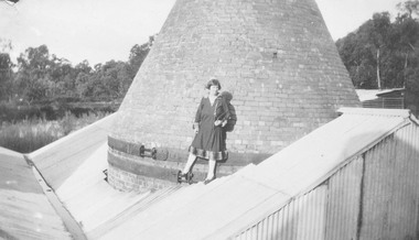
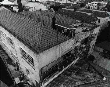
Photograph, Photograph captioned "On top of insulator factory". No name or date recorded, however Ringwood Insulator Works operated throughout the early 1900s producing ceramic insulators
Catalogue card reads, "On top of insulator factory". -
 Ringwood and District Historical Society
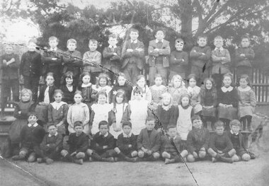
Photograph, Ringwood State School pupils, Maroondah Highway (corner of Ringwood Street) - early 1900s
Written on backing sheet, "Ringwood State School pupils then in Whitehorse Rd." -
 Ringwood and District Historical Society
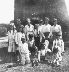
Photograph, Catholic Church Picnic - Ringwood families in early 1900s
Black and white photograph of group of young people. (3 copies)Typed beneath photograph, "Catholic Church Picnic (undated ?) Back row. Mrs. Lawlor, Mrs. Pratt, M. Cunningham, T. Hunt - ,N. Lawlor, L. Hunt, H. Pratt. Front - L. Pratt, H. Hunt, - , K. Pratt, A. Pratt, M. Pratt" -
 Ringwood and District Historical Society
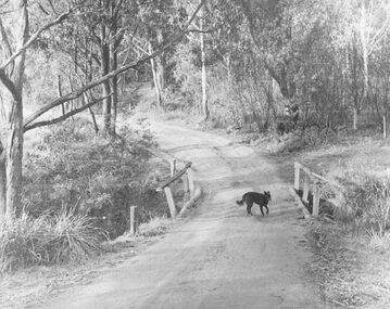
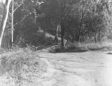
Photograph, Deep Creek Road early 1900s
Black and white photograph of bend in unmade road. Bridge with black dog standing on bridge. Forest area on either side of road. (2 copies)Typed below photograph, "Deep Creek Road in early days". -
 Ringwood and District Historical Society
Photograph, Deep Creek Road bridge early 1900s
Black and white photograph taken from unmade road. Road zigzags over bridge with wooden balustrades. Bushland setting. (3 copies)Typed below photograph, "Deep Creek Road bridge in the early days". -
 Federation University Historical Collection
Photograph - Photographs - black and white, Ballarat School of Mines: Lydiard Street Campus Buildings, early 1900s, c1978
These photographs were taken just before structural modifications and connecting overhead walkways were commenced in 1978.1: Art School opened in 1915 on the site of the original SMB building.It was converted from the abandoned court house. Also Administration building including the teaching and other spaces. .2: "Old Chemistry building" showing the south side and west end. .3: Art school on the left, Ballarat Brewery boiler chimney stack in centre background, Administration building on the right. .4: Entrance on the north side of Art School building .5: South side entrance of Administration building.ballarat school of mines, buildings, a building, administration building, lydiard street south, smb campus -
 Federation University Historical Collection
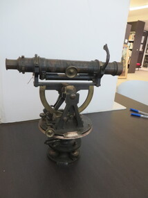
Scientific Instrument, Theodolite: Early 1900s, c1860
The theodolite is used in surveying and measures vertical and horizontal angles. Placed on a tripod, it is used to find angles in road building, tunnel alignment and other civil-engineering work. The theodolite was used at Ballarat School of Mines in the surveying course. It is possible that this instrument was imported by Flavelle Bros & Co having been made to their order by a European instrument makerTheodolite (without a matching tripod) with four leveling screws at the base. Telescope not fully rotatable, ends can be interchanged. Underslung levelling bubbletheodolite, surveying, european instrument, importers, ballarat school of mines, flavelle bros & co, measuring angles, road building, civil engineering -
 Stanley Athenaeum & Public Room
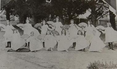
Photograph, Miss Wilcox's Dancing Class Early 1900s
Part of the social history of the Stanley community and the life of children in rural AustraliaBlack and white photograph A group of 12 girls in white frocks with fansstanley children girls leisure dancing -
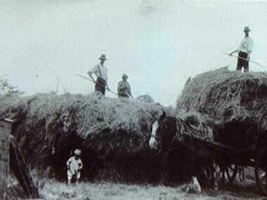 Inverloch Historical Society
000247 - Photograph - 1900s - Pound Creek - Henderson - Hay making - E Henderson - Reverse side - slightly larger copy of photo
-
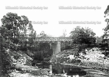 Nillumbik Historical Society Incorporated
Photograph - Black & white photograph, Bridge Over the Diamond Creek with Two Cows Looking North Early 1900s
Black & white photographnillumbik, diamond creek, iron bridge -
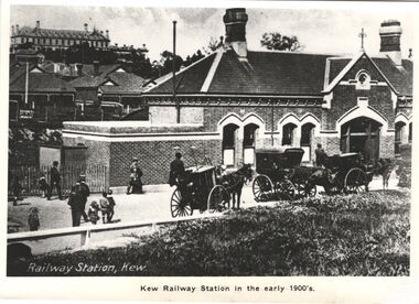 Kew Historical Society Inc
Print, Kew Railway Station in the early 1900s
Kew Railway Station (1887-1959). ‘Kew Railway Station’ in Denmark Street was the terminus of the Kew Line, which extended from Hawthorn Station to just south of Wellington Street. The Station opened on 19 December 1887 after a prolonged campaign for a railway by the people of Kew. Due to a decline in patronage, the passenger service ceased operations in August 1952. While a freight service continued for another five years, the line and station were officially closed on 13 May 1957. Subsequently demolished in 1959, the headquarters of VicRoads (formerly Country Roads Board) now stands on the former Station site.This work forms part of the collection assembled by the historian Dorothy Rogers, that was donated to the Kew Historical Society by her son John Rogers in 2015. The manuscripts, photographs, maps, and documents were sourced by her from both family and local collections or produced as references for her print publications. Many were directly used by Rogers in writing ‘Lovely Old Homes of Kew’ (1961) and 'A History of Kew' (1973), or the numerous articles on local history that she produced for suburban newspapers. Most of the photographs in the collection include detailed annotations in her hand. The Rogers Collection provides a comprehensive insight into the working habits of a historian in the 1960s and 1970s. Together it forms the largest privately-donated collection within the archives of the Kew Historical Society.A photographic copy of a book plate from 'Kew's Civic Century' (1960) by W.D. Vaughan. The book plate was itself a copy of an early 20th century postcard depicting the Kew Railway Station."Railway opened 1887 - Then as photo states"kew railway station, dorothy rogers, country roads board, vicroads -
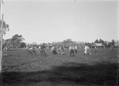 Bacchus Marsh & District Historical Society
Photograph, Football Match at Maddingley Park Bacchus Marsh 1900s
This photo is a very early example of an action image from an Australian Rules football match in a rural area in Victoria. The identity of the two teams is not confirmed. The team with the dark colored uniform is probably the Bacchus Marsh football team. The other team is possibly Parwan. The style of uniforms suggest the date of the photo is from around 1910 or possibly a few years earlier. This item has particular historic and social significance as an action image of two of the early sporting teams of Bacchus Marsh and district. These type of images are very rare for teams outside of the major metropolitan competitions such as the Victorian Football League of Victorian Football Association. It therefore provides a rare and fascinating depiction of an early football game as it was played and the ground conditions in which footballers played in the early 1900s.A black and white photograph produced from a digitized glass negative held by the State Library of Victoria titled, ‘Men and boys playing football on an oval set among trees and fields’ ca. 1910, Pictures Collection, State Library Victoria, H92.433/20. The description for the image held by the State Library of Victoria does not identify the location where the image was taken. By close comparison with other images of Maddingley Park held by the Bacchus Marsh and District Historical Society the location has been identified as Maddingley Park, Bacchus Marsh. A significant identifier for this image is the presence of the Evans Pavilion in the background which was built in 1896. Trees and statues in the background on the left side of the image also match other images of Maddingley Park from this time.australian rules football, bacchus marsh football club, australian rules football action images -
 Bacchus Marsh & District Historical Society
Map, Coimadai Parish Map, County of Bourke. Circa 1890s-1900s
The cadastral Parish of Coimadai, a subdivision of the County of Bourke, lies directly north of the township of Bacchus Marsh. The date of this map is uncertain. T.F. McGauran the person who made a photo-lithographic copy of the map was in charge of photo-lithography at the Victorian Department of Lands and Survey in the late 19th century until about 1910.A single page paper map showing the map for the Parish of Coimadai in the County of Bourke. A cadastral map showing parish boundaries and land ownership. A rectangle shaped area is missing from the centre of the map due to a tear or deliberate excision. The map is pasted into a bound volume containing 76 maps or plans in total. High resolution digital image stored on BMDHS computer network. Photo-lithographed at the Department of Lands and Survey, Melbourne by T.F. McGauran 26.8.[??] NOTE. Photo litho from L.P showing temporary surveys and occupation of land prepared for departmental use onlybacchus marsh region parish plans, coimadai parish maps, coimadai parish plan -
![Map, Plan of Subdivision of Crown Portion 23 & parts 24-25, Parish of Korkuperrimul [1900s?]](/media/collectors/5e461d8021ea67224c82f2a1/items/675fe058304668462205d4fb/item-media/675fe0ef304668462205d7d6/item-fit-380x285.jpg) Bacchus Marsh & District Historical Society
Bacchus Marsh & District Historical SocietyMap, Plan of Subdivision of Crown Portion 23 & parts 24-25, Parish of Korkuperrimul [1900s?]
The Parish of Korkuperrimul includes a significant section of the township of Bacchus Marsh and extends in western and northern directions from the township area. The date of the subdivision indicated on this plan has not been established. The engineer's stamp on the drawing shows the firm of Muntz and Muntz who were operating under that name in the early part of the 20th century.A single page paper map showing 20 blocks of land for sale in the Parish of Korkuperrimul. Scale 100 feet to 1 inch. The map is pasted into a bound volume containing 76 maps or plans in total. High resolution digital image stored on BMDHS computer network. Stamped: 'Muntz & Muntz Civil Engineers, Architects & Surveyors, Trustees Chambers ?? Cor Collins Street and Bank Placeland sales bacchus marsh, bacchus marsh victoria maps, land sales korkuperrimul parish -
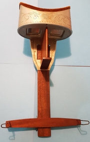 Linton and District Historical Society Inc
Stereoscope, Hand-held Stereoscope, early 1900s
Belonged to the O'Beirne family.Optical device for viewing a pair of images (usually photographs) as a three-dimensional image. Wooden handle, metal eyepiece, small fold-out stand. This stereoscope is an example of the type created by Oliver Wendell-Holmes in the 1860s. Two accompanying sets of stereo cards for viewing (approximately 60 cards altogether) are catalogued separately.stereoscopes, o'beirne family -
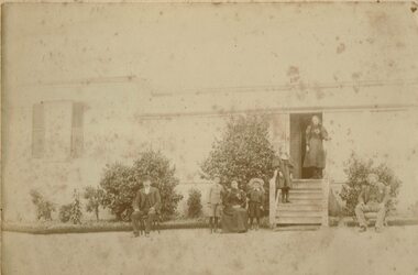 Linton and District Historical Society Inc
Photograph, Unidentified Family at Mt Bute Station, early 1900s
Mt Bute Station was a pastoral lease originally established c.1840 by Duncan Hoyle. The lease was later transferred to Charles and William Oakley (c.1853), and then to Matthew Hamilton Baird (c.1858). Sir Samuel Wilson acquired the lease in 1872 and purchased the property in 1873. Mt Bute was subdivided for soldier settlement blocks after World War I. The home block - house and 700 acres - is currently owned (2018) by the Collins family.Faded photograph mounted on cream-coloured card, which shows a family outside the residence at Mt Bute pastoral station. The photograph is undated but is believed to have been taken in the early twentieth century. Photograph shows two men, and a woman seated in chairs outside a house. A row of shrubs is across the front of the house. Two young boys are standing either side of the woman. Two young girls are standing on the steps leading to the entrance of the house. The people in the photograph have not been unidentified. A copy of the photograph was made in 2019 and is with the original.mt bute station [pastoral station] -
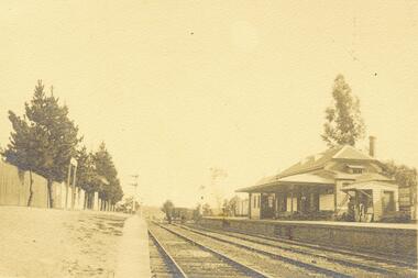 Ringwood and District Historical Society
Photograph, Ringwood Railway Station circa 1900s
2 photographs (1 large black and white- 1 smaller sepia)Typed below large photograph, "Ringwood Railway Station early in the century". -
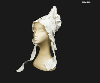 Whitehorse Historical Society Inc.
Headwear - Bonnet, c. 1850
Owned by members of donor's family in 1850s.White cotton bonnet decorated with embroidered Anglais and trimmed around face and hem. Ties for under chin. Worn in 1850s. Night bonnet.costume, female headwear -
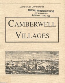 Surrey Hills Historical Society Collection
Book, Camberwell Villages, 1992
Some of Camberwell's 'villages' can be traced back to the 1850s. This small booklet explains how some of them developed.Some of Camberwell's 'villages' can be traced back to the 1850s. This small booklet explains how some of them developed.camberwell region, railways, 1882, balwyn, (mr) andrew murray, belmore, (mr) mark collier, boroondara, deepdene, chatham, canterbury, mont albert, ingelfinger family, staig family, surrey hills, (mr) john knipe -
Eltham District Historical Society Inc
Folder, Richard Lane, 1850s
Folder of information on Richard Lane, Eltham, 1850srichard lane -
Eltham District Historical Society Inc
Folder, James Bailey, 1850s
Folder of information on James Bailey, Eltham 1850sjames bailey -
Eltham District Historical Society Inc
Folder, Edwin Bailey, 1850s
Folder of information on Edwin Bailey, Eltham 1850sedwin bailey -
Eltham District Historical Society Inc
Folder, David Ballard, 1850s
Folder of information on David Ballard, Eltham 1850sdavid ballard -
Eltham District Historical Society Inc
Folder, Thomas Batt, 1850s
Folder of information on Thomas Batt, Eltham, 1850sthomas batt -
Eltham District Historical Society Inc
Folder, Booth Family, 1850s
Folder of information on Booth Family, Eltham, 1850srobert booth, sarah booth, elizabeth booth, amos booth -
Eltham District Historical Society Inc
Folder, Benjamin Bowater, 1850s
Folder of information on Benjamin Bowater, Eltham, 1850sbenjamin bowater -
Eltham District Historical Society Inc
Folder, Isaac Briggs, 1850s
Folder of information on Isaac Briggs, Eltham, 1850sisaac briggs -
Eltham District Historical Society Inc
Folder, William Clarke, 1850s
Folder of information on William Clarke, Eltham 1850swilliam clarke -
Eltham District Historical Society Inc
Folder, Thomas Cochrane, 1850s
Folder of information on Thomas Cochrane, Eltham, 1850sthomas cochrane