Showing 151 items matching "a white roof-tree"
-
 Bendigo Historical Society Inc.
Photograph - T C WATTS & SON COLLECTION: HARGREAVES STREET, BENDIGO, 1930
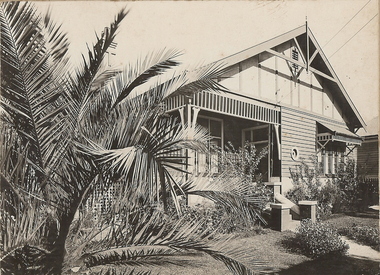
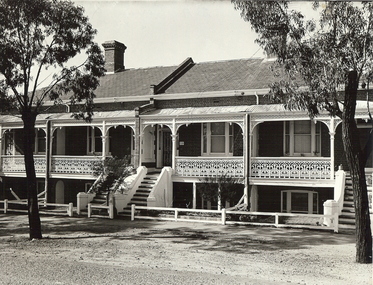
William James Trembath (13/4/1877-27/3/1930) was a draper who lived with his wife Mary Florence (nee Ellis) ( 1877 -29/7/1932) at 521 Hargreaves Street. They had married in 1901. Also living with them in 1924 was their daughter, Mavis Eileen who was a typist.Black and white photograph mounted on rectangular brown board. House, weatherboard, corrugated iron gabled roof, cross and finial to exterior of gable end, brick chimney, decorative, twin pots, battens to gable ends, rectangular louvred vent, telephone connections, leadlight porthole window, awned 4 light window, frieze to awning and verandah, masonary steps, cement path, lawns. Palm tree front left hand side of house. On back of photo ' £1200, Mrs. Trembath, Hargreaves Street'Frank A. Jeffree Photo Bendigobendigo, business, t c watts and son, s -
 Bendigo Historical Society Inc.
Photograph - T C WATTS & SON COLLECTION: 29 PYKE STREET, BENDIGO, 1927
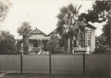
Thomas Crouch Watts was born on March 7th. 1865, to Joseph and Susan Watts. Before the real estate business commenced, Thomas and his brother were in partnership as booksellers and stationers in a shop at View Point. Thomas lived in a fine house in Rowan Street, which was called 'Ottawa' Thomas started his real estate business in the early 1900s in a shop in View Street. His daughter Edna was the book keeper and typist, Stewart Watson was the salesman and Stanley Phipps (Edith Lunn's father) was the property manager and valuer. When Thomas Watts died in 1914, his daughter took over the running of the business. She married Stewart Watson in 1918. Eventually the name of the business was changed to Bishop and Earl. From a letter from Edith Lunn re T.C. Watts & Son. 'The firm of T.C. Watts & Son later became Bishop and Earl. When the firm of Bishop and Earl ceased to operate after the death of Edith Lunn's father, S.P. Bishop, Miss. June Parry, Secretary of the BHS was a member of staff. June rescued all the photos of properties listed for sale from the office and placed them into the custody of the BHS.' Black and white original photograph mounted on grey board. House, weatherboard, corrugated iron roof, verandah, picket fence, wooden fretwork on gables and windows. Decoration along roof line, one chimney visible , garden with two palm trees. Bay window RH side. Harrison's Est £1150, 29 Pyke Street Bendigo written on back of image. Date: 9 Dec 1927. stamped on back.A. Jeffree, Bendgoplace, building, residential, previous reg. no. mp81 part of a collection of photographs used by estate agent t.c. watts and sons, bendigo to show potential purchasers. -
 Bendigo Historical Society Inc.
Photograph - T C WATTS & SON COLLECTION: 'TIRRANNIE' GOLDEN SQUARE, 1929
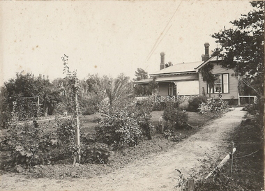
Thomas Crouch Watts was born on March 7th. 1865, to Joseph and Susan Watts. Before the real estate business commenced, Thomas and his brother were in partnership as booksellers and stationers in a shop at View Point. Thomas lived in a fine house in Rowan Street, which was called 'Ottawa' Thomas started his real estate business in the early 1900s in a shop in View Street. His daughter Edna was the book keeper and typist, Stewart Watson was the salesman and Stanley Phipps (Edith Lunn's father) was the property manager and valuer. When Thomas Watts died in 1914, his daughter took over the running of the business. She married Stewart Watson in 1918. Eventually the name of the business was changed to Bishop and Earl. From a letter from Edith Lunn re T.C. Watts & Son. 'The firm of T.C. Watts & Son later became Bishop and Earl. When the firm of Bishop and Earl ceased to operate after the death of Edith Lunn's father, S.P. Bishop, Miss. June Parry, Secretary of the BHS was a member of staff. June rescued all the photos of properties listed for sale from the office and placed them into the custody of the BHS.'Black and white original photographs (3) mounted on rectangular brown board. House, weatherboard, corrugated iron roof, return verandah with crossed wooden balustrade.4 chimneys. Garden with small palm tree. On back : Mr. Taylor.. 'Tirrannie', Golden Square, £ 2100 , inc. billiard table, linos, overmantle, 4 1/2 acres. 'April 1929' written faintly on back of one image. On front a sticker attached ' April 1929 ' Tiirannie' Golden Square, £2500 - 4 1/2 acres' ( possibly a later attachment for display purposes ) Used by Estate Agent T.C. Watts & Son to show potential purchases in 1929. Previous Reg. No. 'MP 5'. See also Reg. No. 2000.006.01Frank A. Jeffree, Bendigoplace, building, residential -
 Bendigo Historical Society Inc.
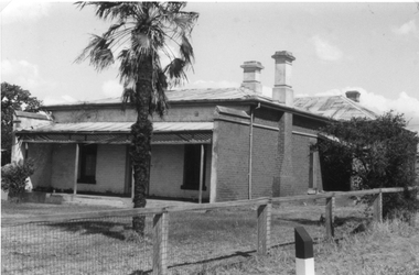
Photograph - ST LUKE'S ANGLICAN VICARAGE AND CHURCH, WHITE HILLS, c.1920
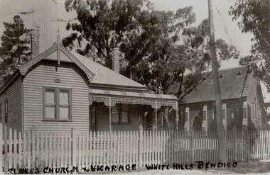
Copy of black and white photograph showing view of weatherboard double-fronted house, decorative ? Boards, verandah lacework, decorative brick chimneys ??. Roof, double-hung windows. Brick church adjacent, vented slate roof, buttressed walls, Gothic windows. Picket fence along footpath. SEC? pole. Trees in background. Inscriptions: on front in Indian ink written across bottom of image 'St Luke's Church and vicarage, White Hills Bendigo'.buildings, church, st lukes, white hills -
 Bendigo Historical Society Inc.
Photograph - CATHEDRAL TERRACE
black and white photo of terrace houses, two storey, staircase in front of terraces leading to balcony. Slate roof, ironbark street trees x 2 , 2 chimnmeys, rail fence. Inscription stamped on back 'photo/A. Doney, Bendigo' '23A Terrace corner Short and McKenzie Streets'in ball point pen on back.A. Doney, Bendigobuildings, residential, terrace -
 Bendigo Historical Society Inc.
Document - MALONE COLLECTION: GREETING CARDS, 1926
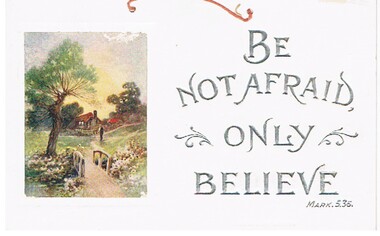
Document. Greeting Cards. Large white card with two holes at the top for hanging. It has a piece of orange cord through it. On the right, printed in silver capitals is: 'Be not afraid only believe Mark. 5.36.'. There is a piece of scroll work on each side of 'only'. On the left is a coloured picture of a brown house with a red roof. In the foreground is a path leading over a bridge to the house. On each side of the bridgeare flowers. On the left is a tree. Nearer the house, on the path is a man using a hoe or similar.person, greeting cards, malone collection, malone collection, greeting cards -
 Bendigo Historical Society Inc.
Photograph - MICHELSEN COLLECTION: SOUND SHELL, ROSILAND PARK, BENDIGO
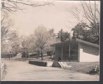
Photograph, Sound Shell, Rosiland Park, Bendigo, constructed of cream bricks and sloping roof. Stage out front with steps to the side. There are three people sitting on the edge of the structure near the white poles that support the roof. A large collection of trees surround the shell in the park.Two other seats in picture, one left and the other bottom right.bendigo, parks and gardens, sound shell rosiland park -
 Bendigo Historical Society Inc.
Photograph - OLIVE PELL COLLECTION: STEREOSCOPE OF A CHURCH
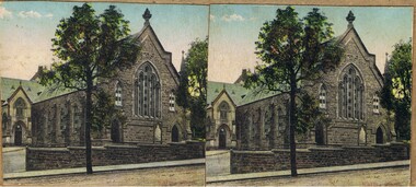
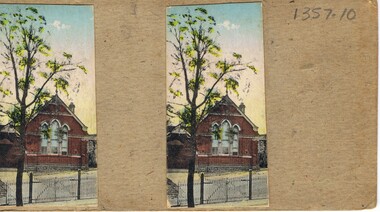
A Stereoscope photograph of a Church. A grey stone building with three entrances two at the front and one to the left side, a large front stained glass window with two smaller side windows. The top of the front pitch of the roof is a finial. To the right behind a tree is a church spire. A stone fence is in the foreground with a white gate and walking path. A large tree is in the middle of the picture.buildings, church, stone, grey stone church. -
 Bendigo Historical Society Inc.
Photograph - OLIVE PELL COLLECTION: PHOTO OF A CHURCH
Red brick Church with large curved top three panelled windows with the blinds three quarters down. A finial is on the top of the roof. A chimney can been seen to the right side of the roof. In the foreground is a white picket fence with a double gate and a tree to the left.buildings, church, red brick, red brick church. -
 Bendigo Historical Society Inc.
Photograph - TOWN HALL SANDHURST
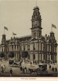
Black and White Photo/Drawing of the Sandhurst Town Hall designed by Vahland and Gesch, Markings on photo read 'Town Hall, Sandhurst'. three flags flying from the roof of the building. Two horse drawn carriages on roadway. Adult men and women on road and footpath. Thjree established trees along footpath.buildings, town hall, sandhurst town hall, sandhurst town hall, town hall, sandhurst, vahland and gesch, vahland, gesch -
 Numurkah & District Historical Society
Photograph - Photo of building
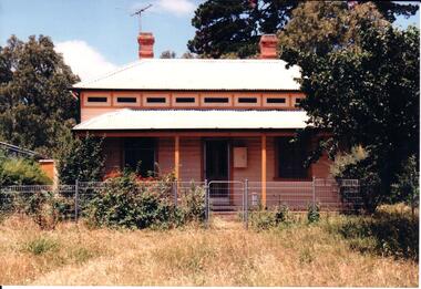
Black & White photo of white roofed house set back with a large tree on the right -
Numurkah & District Historical Society
Photograph - Photo of group
Black & White photo of 2 women and 3 men standing by small trees, with a roof in the background -
 Hume City Civic Collection
Photograph
The architects Terry and Charles Webb designed the church and building work on the church commenced in late 1879 with a further addition completed in 1918.A coloured photograph of St. Mary's Church is Sunbury. The bluestone building with white stone trim and a pitched slate gable roof is surrounded by parkland and tall elm trees.webb, terry and charles, clarke, william j. t. 'big bull', francis, james g., george evans collection -
 Hume City Civic Collection
Photograph, early 1990s
The bluestone house 'Amelia' was built in 1914/1915 and has included a combination of Victorian and Federation styles. Andrew Patterson the first owner lived there for over 40 years. It is thought that the bluestone used for the walls came from the first state.A coloured photograph of 'Amelia', a bluestone double fronted house with white wooden trims and a white corrugated roof. A bull nosed verandah stretches across the front of the house. The surrounding garden has been painted out with low growing trees and shrubs.patterson, andrew, amelia, george evans collection -
 Hume City Civic Collection
Photograph, early 1990s
The weatherboard house is one of the six weatherboard cottages which were built on the east side of O'Shanassy Street in the early 1900s. It has been listed in the Heritage Study in 1998. Scheduled as having some significance and recommended for further investigation.A coloured photograph of a weatherboard Victorian cottage with an overhanging verandah across the double fronted building. The weatherboard walls are painted biscuit and the window and door frames are tan. A wooden tile trim painted in biscuit, tan and dark green. There are two stepped chimneys protruding from the white painted corrugated iron roof. The overgrown garden has low growing trees and shrubs.george evans collection -
 Stawell Historical Society Inc
Photograph, 14 Seaby St
Colour Photograph: White brick house, Iron roof. Partially hidden by tree. Wooden fence with carved wooden railing iron gateOn Reverse: 14 Seaby St. Morrie Robson -
 Stawell Historical Society Inc
Photograph, Armstrong’s Area Houses c 1990's -- 2 Photos -- Coloured
Residence Fountainhead Brewery Armstrong's Est. c 1872. The rear view photograph shows a more recent renovated building. Some evidence of demolition to rear of building (servants stairs etc.) Following notes taken from information in album 9 - "Compare earlier photos and note balcony etc. Later views, This photo early 2003. Owing to timber decay balcony was removed for safety. Finances permitting complete balcony will be replaced. Twin columns and iron lace are not original. Early description mentions statues in "niches" beside door. Female statue left is original. White pedestal at left was male stature damaged by a falling tree. Both statues were fountains." Photographs taken by Mr. Don Richard and held in Album 9b Armstrong’s Area.Two coloured photographs, of a brick double story building. The front view of the building has 4 windows and 2 doors. Two white columns at the entrance with decorative iron work support the roof of the porch with 2 white chairs and a table on top. Either side of the entrance door are 2 white wall indents "niches" with pot plants. The second photo show the back view of the two story building with a single story building attached that has a tin roof. A timber fence with a gate shows the side entrance to the single story building. 648M NHNN 8H01HPRO3 WIMMERA 1MHGINGstawell -
 Stawell Historical Society Inc
Photograph, Brick Home at 26 Seaby Street
Brick Home 26 Seaby Street. Recent owners C. Wehl, and Max Holmes.Black and white photograph of a large brick home with veranda. Slate roof with finials on gable ends and barge boards, Garden and trees on right side of photograph.stawell -
 Stawell Historical Society Inc
Photograph, Brick Home at 9 Seaby Street -- 2 Photos
Brick Home 9 Seaby Street originally built by Crothers Family. Now owned by Mr. and Mrs. Peter Carey, The house is located on the corner of Luke and Seaby St. This house was imported from Canada. All components are numbered. It has a cavity wall construction. The present owners have carefully restored this house.Two black and white photograph of a large brick home. Roof is corrugated iron with a veranda across the front. A large palm tree in front. Fence along the side is wire mesh with timber supports. The second photo is a closer side view of the house. stawell -
 Whitehorse Historical Society Inc.
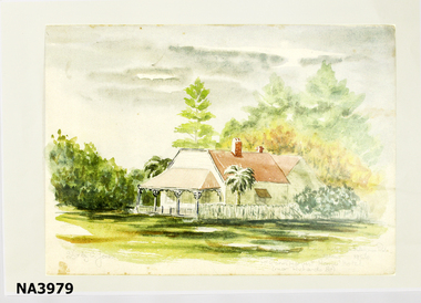
Painting - Copy of painting, 1956
Early Mitcham settlers Elizabeth and John McGlone ran a hotel 'The Harvest Home Hotel' in the front room of their home in Whitehorse Road Mitcham. The hotel closed in 1889Copy of a watercolour painting of McGlone's Harvest Home Hotel Mitcham by Shirley Jones. Cottage with verandah is white with pink roof centre with palm trees either side of verandah with trees behind. Shirley Jones in bottom left corner . Right front corner Early Hotel Whitehorse Road Mitcham 1956 McGlones Harvest Home Hotel (near Richards Street)illustrations, reproductions -
 Whitehorse Historical Society Inc.
Photograph, Hut on Daisy Campbell's property, 1/11/1971
Black and white photograph of three black and white views Daisy Campbell's ti tree and mud hut showing - 1. Hut of Ti-Tree and Mud - hut originally had a bull rush thatched roof, which was later covered with corrugated iron.. 2. Further view. 3. Interior view showing wall construction and remaining thatched roof.campbell, daisy, campbells croft -
 Rutherglen Historical Society
Image, 1970s
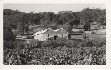
Our cellar, which was built from local stone by Esca in 1914, sits on the side of the Warby Ranges, overlooking the beautiful Taminick Valley and our estate vineyard.Black and white photograph with a view over a vineyard of a double roofed building. Hills with substantial tree cover in the background.On back of photo: "95% [lower case c in small circle] Booth Bros."wineries, north east victoria, wine industry, booth brothers winery, taminick, winemaking, glenrowan -
 Rutherglen Historical Society
Image, 1970s
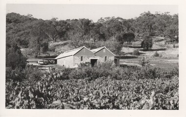
Our cellar, which was built from local stone by Esca in 1914, sits on the side of the Warby Ranges, overlooking the beautiful Taminick Valley and our estate vineyard.Black and white photograph with a view over a vineyard of a double roofed building. Hills with substantial tree cover in the background.On back of photo: "Booths?"wineries, north east victoria, wine industry, booth brothers winery, wineries, north east victoria, wine industry, booth brothers winery, taminick, winemaking, glenrowan, taminick, winemaking, glenrowan -
 Rutherglen Historical Society
Photograph - Image, 1970s
Greatly relieved by his son’s safe return from war, John Richard Stanton (1872-1955) buys a parcel of productive farming land for his son John Charles “Jack” Stanton (1895-1989) to give him a “good start in life”. Jack’s wife Ethel Capper, devised the name “Gracerray” for the property to honour her sister Grace and the nearby Murray River. After the First World War, fourth generation Jack Stanton (1895-1989) with the help of his father started building a new winery (at the current site of the winery and cellar door) called ‘Gracerray’ named after his wife’s sister Grace and the Murray River. It is pronounced “Grah-sair-ray”. Jack built Gracerray around some existing cement open top vats from a winery that was demolished after phylloxera ravaged the region in the late 1890s. He used second hand materials from the defunct Great Southern gold mine and propped up the roof with huge tree trunks. Jack only made fortified wine up until the 1960s when he and his son-in-law Norman Killeen started making red wine to meet changing Australian tastes.Black and white portrait photograph of a mature man in suit and tie.On back of photo: "145% [upper case E in small circle] J.C. Stanton" wineries, north east victoria, wine industry, j c stanton, stanton & killeen winery, jack stanton -
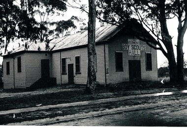 Whitehorse Historical Society Inc.
Photograph - Black and white photograph, Scout Hall Vermont
The First Vermont Scout Group was founded by Rev. Mc Keon of the St. Lukes church of England about 1922.Black and white photograph of Vermont First Boy Scout Hall. Weatherboard building with iron roof. Trees in foreground.scout hall vermont, vermont scout hall -
 Mt Dandenong & District Historical Society Inc.
Photograph, View From Ernest Road To Site Of "Kia-Ora"
John Lundy-Clarke grew up in the Kalorama/Mt Dandenong area and later in life (1972-74) began to write a comprehensive history of the area working from an original settlement map in an effort to cover all areas. The photograph taken c1973 from Ernest Road looks over the site of the Kia-Ora guesthouse which is marked by the oalm tree that can be seen at the front of the flat roof close to the gum tree trunk. Situated on Barber’s Road, ‘Kia-Ora’ was built in 1912 by George Barber. It was later leased by a Mrs Pemberthy. “Kia-Ora’ was one of four places connected when the telephone was brought into the district in 1912. The other places were ‘Mountjoy’, ‘Cherry Farm’ and ‘Callum House’. ‘Kia-Ora’ was burnt down in 1924.Black and white photograph showing a house with water tank in right foreground and another flat roof centre foreground. There is a handwritten description by John Lundy-Clarke on the reverse.View 1973 from corner of Ernest Rd and Outlook Drive Lot 24 Village Settlement looking over the site of “Kia Ora” to the pioneers clearings. The palm tree seen above the flat roof (Rex) on left, is on the exact site of “Kia Ora”. Photo JLCernest road, john lundy-clarke, kia=ors, guest house, guesthouse -
 Mt Dandenong & District Historical Society Inc.
Photograph, View Over Roof of "Kalorama"
Taken in 1908, this photograph, though rather blurry, gives an indication of the location of the early settler properties in the valley in relation to one another. European trees have been planted at 'Kalorama' , the first home of Ellis Jeeves. John Lundy-Clarke grew up in the Kalorama/Mt Dandenong area and later in life (1972-74) began to write a comprehensive history of the area working from an original settlement map in an effort to cover all areas.Black and white photograph looking across hillside with large trees and rooftops visible. Handwritten description on reverse by John Lundy-Clarke.1908 View over roof of “Kalorama” towards the Falls. Paynter’s house on LOT 29 in low centre (now “Yosemite”). Pimms house on LOT 19 above Paynters and beyond scrub. Logan’s house faint above left of “Kalorama”. Dunbar’s LOT 20 beyond Pimm’s orchard. Gum trees on right were on Price’s LOT 19 now Tosari Rd area. It was one of these that figured in the episode of the runaway log in 1930. It leaped in one bound over Barbers Road at bottom of scrub in centre of picture then over Logan’s house.kalorama, ellis jeeves, jeeves -
 Mt Dandenong & District Historical Society Inc.
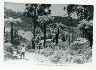
Photograph, View From Doughty's Road 1913
Mt Calvin, the homestead of Jeanie and Willie Richardson can be clearly seen in the clearing above the men in the picture. The white roof of the Barber homestead is on the right of the picture. A landslide in 1934 destroyed the tree ferned area. John Lundy-Clarke grew up in the Kalorama/Mt Dandenong area and later in life (1972-74) began to write a comprehensive history of the area working from an original settlement map in an effort to cover all areas.Black and white photograph that is a copy of a Rose series postcard titled 'The Picturesque Road to Mt. Dandenong. Vic.' It shows two men (probably Rose Series employees), one sitting and one standing at the edge of an unmade road. Large tree ferns line the roadside. Handwritten inscription on reverse by John Lundy-Clarke1913 View east from Doughty’s Road showing Jeannie Richardson’s home through the gap in the trees. A little to the right of and below centre of picture can be seen George Barber’s home with Barbers Road turning around the wagon shed that was a little up the hill from the house. The tree ferns in the picture were destroyed in the landslide of 1934. In the distance at the right can be seen F.M. Childs Homestead complex with the Richardson paddocks beyond it.mt calvin, jeanie richardson, willie richardson, george barber, landslide, tree fern -
 Mt Dandenong & District Historical Society Inc.
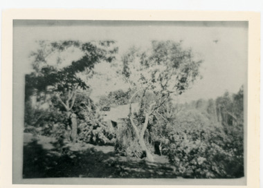
Photograph, Harmony Vale Homestead
This photograph of 'Harmony Vale' homestead was taken by Daisy Rowse c1917. It is a copy of the original. 'Harmony Vale' was the home built c1860 by early settler Jabez Richardson and his wife Sarah Ann. Jabez Richardson arrived in 1855 with the Child and Jeeves families. The building and barn stood until 1933. The name Harmony Vale was given to the early settlement.Black and white photograph with the roof of a house in centre surrounded by trees. harmony vale, daisy rowse, jabez richardson, richardson, homestead -
 Mt Dandenong & District Historical Society Inc.
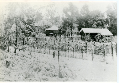
Photograph, Erith Lane
Erith Lane would have been named after Eliza Erith, the wife of Thomas Hand of Mountain Grange. The house made of slabs and bark pictured (centre) is where the family lived before Mountain Grange was built. Mabel Hand, Thomas and Eliza's youngest daughter stated that she was born in the bark hut in 1881 and they moved into the new home the same year. Cherry Farm, the roof visible behind the centre building, was the home of William Hand, son of Thomas and Eliza. He lived here with hs wife, Harriet Toghill, before moving to live at Mountain Grange after 1905.Black and white photograph showing a scene under heavy snow. Two cottages and a rooftop visible. Snow laden vines forming the front fence. Taller trees visible in the background. Reverse of photograph has handwritten description by John Lundy-Clarke.Erith Lane under snow. House in passion fruit Ivory’s holiday home 1921. Building in centre was Hand’s 28’ by 22’ house of slabs and bark. The first house on top of the whole Dandenong Range built 1871. Large roof behind it was “Cherry Farm”.eliza erith, eliza hand, mabel hand, thomas hand, william hand, erith lane, kalorama, snow, mountain grange, cherry farm, harriet toghill