Showing 48 items matching "abandoned buildings"
-
 Melbourne Water
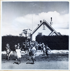
Photograph, North Cocoroc State Primary School, 1950s
As the Yarra became unsuitable as a source of water, several attempts were made to find alternative sources for the growing population of Melbourne. It was not until 1891 that the efforts to sewer Melbourne came to fruition with the setting up of the Melbourne Metropolitan Board of Works (MMBW), now known as Melbourne Water. From 1891 until 1992, it was the responsibility of the MMBW to safeguard public health by providing a sewerage system and a safe water supply system. In 1992, The MMBW merged with a number of smaller urban water authorities to form Melbourne Water. The township of Cocoroc was created in 1894 at the Metropolitan Sewage Farm (now the Western Treatment Plant) to house the workers it employed. The name 'Cocoroc' means 'frog' in the language of the Wathaurung people — the Traditional Owners of the land the treatment plant was built on. By the early 1950s there were nearly 100 houses, a town hall, football ground (and team), swimming pool, tennis courts, four schools and a post office, and by the 1970s some 500 people were living in Cocoroc. As it became too expensive for the MMBW to subsidise, Cocoroc was abandoned. By 1973 most of the houses and other buildings were demolished or moved to Werribee. All that is left now of Cocoroc are two small, empty, concrete swimming pools, a few weatherboard sheds and a big iron water tank. This photograph detailing an exterior view of the North Cocoroc State Primary School, is historically significant as it captures children at play within a purpose built community. The School that was one of four was built to educate the children of the MMBW workers. As the school no longer exists, this photograph is the only tangible evidence left of the building, also showcasing the style of buildings in this era. cocoroc, township, school, mmbw, melbourne metropolitan board of works, melbourne water -
 Sunshine and District Historical Society Incorporated
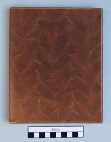
Book, Sunshine High School Prefects between 1958 and 1971, Prefects Pledge - SUNSHINE HIGH SCHOOL, 1958 to 1971
Sunshine High School had the system of Prefects being elected by the students from candidates nominated by the teachers. It is unknown whether the exact number of votes each elected Prefect received was ever released to the students. Prefects were used to supervise the behaviour of other students, and to book them for offences such as not wearing caps on the way to and from school. In the Pledge book there are empty pages after 1971 so it is unknown whether the signing of the Prefects Pledge was abandoned after then. Sunshine High School existed in its own right in the Melbourne suburb of Sunshine for a relatively short period between 1955 to 1991. The school amalgamated with the following five secondary schools: Sunshine Technical School, Tottenham Technical School, North Sunshine Technical School, Sunshine West High School, and Ardeer High School to form the multi campus Sunshine College in 1992. The buildings of the former Sunshine High School on Ballarat Road now form part of the Sunshine Campus of Victoria University. The book is a historical record of the names and signatures of the Prefects that signed the Prefects Pledge, and served the Sunshine High School over the 14 years between 1958 to 1971 inclusive. It also contains the names and signatures of witnesses to the signatures. Small brown hardcover book with cream pages. Contains the Prefects Pledge hand written in black ink, and the signatures in blue and black inks of boy and girl Sunshine High School Prefects from the years 1958 to 1971sunshine high school, prefects pledge, book, 1958 to 1971, prefects signatures -
 Whitehorse Historical Society Inc.
Article, History buffs cheery as old school revived, 2001
Burwood State school, built 1865.Burwood State school, built 1865, abandoned and left derelict for a decade is about to become headquarters for the Victorian Association of School Councils. Box Hill Historical Society began to lobby for funding in 1995 to have the building restored and put to community use.Burwood State school, built 1865.primary schools, burwood primary school, no 461, victorian association of school councils, box hill historical society -
 Ballarat Heritage Services
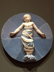
Photograph - Colour, Ospedale Degli Innocenti, Firenze, 2017, 11/2017
The buildings architect was Filippo Brunelleschi. The Ospedale degli Innocenti was a charity institution that was responsible for the welfare of abandoned children. It represented social and humanistic views of Florence during the early Renaissance. Above each column is a ceramic tondo. These were originally meant by Brunelleschi to be blank concavities, but around 1490 Andrea della Robbia was commissioned to fill them in.[7] The design features a baby in swaddling clothes. A few of the tondi are still the original ones, but some are nineteenth century copies. The Ospedale Degli Innocenti, Firenze museum holds a number of part tokens that a mother would leave with a child - keeping the other part in the hope they would be reunited, A number of photographs of the Ospedale Degli Innocenti in Florence, Italy. florence, firenze, hospital, filippo brunelleschi, the ospedale degli innocenti, tokens, orphanage -
 Federation University Art Collection
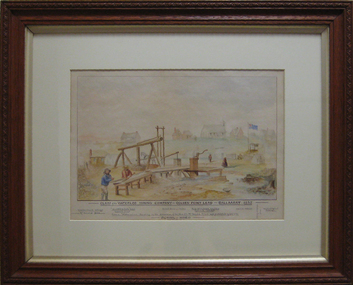
Painting, Claim of the Waterloo Mining Co, 1909
The painting is thought to be a copy of a similar earlier work. An Australian flag flying on a flagpole is an interesting addition. The puddlers depicted in this painting were the Kneeshaw Brothers. This item is part of the Federation University Art Collection. The Art Collection features over 2000 works and was listed as a 'Ballarat Treasure' in 2007.Framed watercolour of the Waterloo Mine, Ballarat. This site is now known as Lydiard Street South, and the church on the hill is the former Wesleyan Church. After the church was abandoned it was purchased by the Ballarat School of Mines and used as a Museum for many decades. Today the Federation University Hairdressing school uses the building for their classes. art, artwork, waterloo mine, ballarat, mining, wesley church, lydiard street, kneeshaw, kneeshaw brothers, lydiard street south, ballarat school of mines -
 Federation University Art Collection
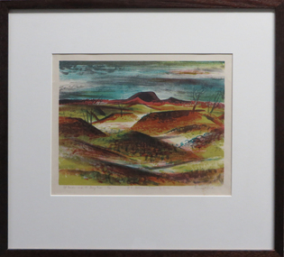
Work on paper - Artwork - Printmaking, Jack, Kenneth, "Mt Porndon and the Stony Rises - No 6 Volcanic Plains of Victoria" by Kenneth Jack, 1962
Kenneth JACK AM MBE RWS, (5 October 1924 – 10 June 2006) Australian watercolour artist Kenneth Jack who specialised in painting the images of an almost forgotten outback life; old mine workings, abandoned ghost towns, decaying farm buildings. He became a professional painter at the age of 39 after giving up his job as senior instructor at the Caulfield Institute of Technology. In 1977 he was elected to The Royal Watercolour Society and in 1982 was awarded the MBE, and the Order of Australia (AM) followed in 1987. Framed three block lino print showing the volcanic plains of Victoria around Stony Rises. It is Number 6 in the Volcanic Plains of Victoria series. Donated through the Australian Gifts Programme by Katherine Littlewood.31/40artwork, artist, kenneth jack, printmaking, volcano, mt porndon, mount porndon, linocuts -
 Melton City Libraries
Document, Minns Family Reunion, 2004
"A perpetual spring in the adjacent creek provided a steady supply of fresh water to the site on which the homestead is built. Although we can not be certain of the identity of the builder, the first stage of ‘The Willows’ homestead appears to have been constructed in the mid 1850s. The house is situated on Crown Allotment No.1 (No Section), Parish of Kororoit, an allotment of 5 acres 3 roods 4 perches. Although it had surveyed the land, the Crown did not offer it for sale until 22nd November 1861, at which time it was purchased by Charles March Williams. (Although the property is directly opposite and immediately adjacent to the Township of Melton, and was sold as ‘Suburban Allotment 33’, it was situated within the Shire of Braybrook rather than the Shire of Melton until 1917.) Considerable improvements had taken place on the land prior to the Crown sale. When CM Williams purchased the allotment in November 1861 he paid £23.5.0 for the land itself, and valued the improvements at £400. Even allowing for some exaggeration by Williams, this is an extremely high valuation for improvements, and must have included a house. Some local research has claimed that in 1858 Williams had taken over the interest of a Mr Parkinson in the property, and that Parkinson built the house upon taking possession of the land c.1855. It was definitely built by 1861, when a map shows a square building on the site marked as ‘House’. The property is important in the district for its association with the establishment of the pound. The district pound had been established in 1854, when George Scarborough of Mount Cottrell (Mt Cottrell Road, south of Greigs Road) was appointed pound-keeper. Scarborough resigned in 1857. The pound was moved to Melton following agitation from local farmers and Charles March Williams appointed pound-keeper on 26th April 1858. Williams, the son of a doctor, had been born in London. Reminiscences of local residents of the time, as recorded in the Express newspaper, note Williams’ success in breeding horses on the property. Sales of up to 60 guineas were noted. Whether this was from Williams’s own stock or from unclaimed pound stock is not made clear. Williams appeared before a government inquiry in 1860 and advocated registration of all stock brands in the State. Williams died in 1862 leaving a widow, Catherine, and five living children aged 15 years to five months. At the time of his death Williams had entered negotiations with one Matthew Devenish and had a mortgage of £100 on allotments 1 and 2, Parish of Kororoit. Catherine Williams was appointed pound-keeper on 2 September 1863, with her eldest son Charles as her assistant. Her tenure was short for on 22nd March 1864 George Minns senior paid Matthew Devenish £135 for allotments 1 and 2 Parish of Kororoit (considerably less than Williams had claimed the property was worth in 1861) and on the same day paid William Tullidge £45 for the adjoining allotments 3 and 4. In April 1867, James Ebden Minns, the newly married son of George senior became the owner of The Willows property having entered into a mortgage arrangement with his father to the extent of £200. At the time George Minns was residing in Kaarimba having left Melton in 1867 for a short trip to England and upon his return having taken up a selection in the Kaarimba district with his son Frederick who had a hotel licence there. James paid out the mortgage on 2-1-1873. James Minns was appointed pound-keeper in 1872; in 1885 the pound was moved elsewhere and Minns purchased the old pound site and added it to his farm. The Willows residence underwent a major change about this time. A two room extension, similar in style but with a lower elevation was added to the original rear of the house with a chimney matching the distinctive originals. Window arrangements did not match the original but became a feature of the façade when the new addition became the front of the building. Six buttresses were attached to the east and west walls of the old building, two to the south wall and the whole rendered with mortar to give the appearance of dressed stonework around the windows. Galvanized iron was placed over the shingles and a verandah added on three sides. By 1876 The Willows was the homestead for a thriving mixed farm of 340 acres of which 156 was rented from a H. Ruck. In October of that year the Australasian travelling reporter visited and reported on the property. In common with the nearly every other property in the district the farm had ‘recently’ (generally within the last two years) abandoned cultivation of crops, and turned over completely to cattle pasture. Butter making was the principal occupation of the farm, which had about 50 head of cattle, a large proportion of which were milking cows. The reporter also noted that a ‘large number of pigs are kept upon this farm and are found to be very profitable stock’. Their manure was used in an orchard and garden in which ‘large quantities of lucerne and prairie grass are grown for the use of stock when ordinary feed is scarce’. Two bores attached to deep brick lined wells supplied water for the house in addition to the farm. A commodious timber barn and necessary sheds had also been constructed. Access to the property was improved following the construction of the bluestone ford across the creek c.1887, when the recreation ground came into use. Prior to this date it may have been that the crossing referred to as ‘Mr Minns bridge’ was used. This appears to have been a flimsy structure and has but two references in Council reports in the Melton Express in the 1880’s. It is believed that in the late 1890’s a timber building was added near the rear of the building to house a kitchen, ablutions and laundry rooms and rooms for seasonal workers. This was attached to the house by means of a trellised walkway using the original front entry to the house (long since the back door). A photograph of this building appears in a local history of Melton. This was demolished in recent decades during the period when the house was tenanted (after the Minns family had left). James Minns son, George, took over the property following his marriage to Alice Walsh in 1903. James and Caroline moved into a house on the former JH Games property at the eastern end of Henry Street. George held the position of Shire Secretary for Melton for 40 years. He was a most prominent member of the community being Secretary to, among others, the Melton Coursing Club, the Shooting Club and the Cemetery Trust. He also rode with the hunting parties who sported across the Plains and were entertained at Mount Kororoit. George and Alice had one son, Norman who followed his father into local government and became Secretary of the Shire of Werribee completing a record term in this position. George retired to Werribee in 1951, where he died in 1965. The National Trust records note that James Ebden Minns and his sons were ‘leading men of the district, Justices of the Peace, and Shire Councillors’. It claims that Sir Thomas Bent was a frequent visitor. The Willows passed into the hands of George’s grandson, Bruce Minns and the property was let for a number of years. In the 1960s it became vacant and was subject to vandalism. Major structural problems arose with the part demolition of the roof, the loss of windows and doors and holes dug into and under the floorboards. The outbuildings were particularly targeted. Following widespread public support, the Shire of Melton purchased the house, with 3.75 acres of land, in 1972. In 1975 the Shire of Melton and the Melton and District Historical Society were successful in nominating the building for National Trust classification, and then the Australian Heritage Commission’s Register of the National Estate. The AHC particularly noted its ‘townscape importance’. It was envisaged that the farmhouse would form ‘a picturesque centrepiece to Melton’s planned … historical park, along with Dunvegan bluestone cottage … and similar structures as they become available.’ In a time of great Melton’s ‘satellite city’ development the Council spelt out its broader vision in its submission to the AHC: ‘Melton is destined to become, by the end of the present century, a city of between 75,000 and 100,000 people. Significant relics of the past, such as ‘The Willows’, regrettably will be rare in that situation. It is essential that sufficient tangible links with Melton’s pioneering days remain to promote in the new community a sense of history and continuity’. Under the direction of ‘The Willows’ Restoration Committee and consultant architect John Hitch, all outbuildings, with the exception of the garage and toilet, were demolished and the dwelling house restored. Finances were provided by the Shire of Melton and the National Estate Grants Program, and considerable amount of voluntary labour was provided by the local community. The orchard was removed, and remaining wooden buildings were relocated to provide an open vista for visitors to the Park. The property was furnished with donations from district families keen to preserve this example of pioneer life in the area. The Willows became the headquarters of the Melton and District Historical Society". Invitation to the family reunion at the Willowslocal identities, pioneer families -
 Melton City Libraries
Photograph, Denominational Church and School, Unknown
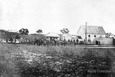
Presbyterian Church Melton Background: A Combined Denominational Church and School was established in Melton by Protestants from the Presbyterian, Episcopalian, Wesleyan and Baptists denominations. A wooden church was built on the flat area east of the Toolam Toolern Creek. A photo of this church shows the buildings with small houses nearby. In the background the bluestone Presbyterian Church built in 1867 can be seen to the north on Yuille and Sherwin street. The flat area beside the road to Ballarat was subject to flooding and the site was eventually abandoned for a settlement. By the latter part of the 1860s the Church of England and Wesleyan bluestone churches were also being erected in the centre of the township of Melton. The commercial centre developed in High Street from Smith to Palmerston Street. Township of Melton Crown Grants Issued Under Common Law refers to the site of the Combined Denominational Church and School on the east side of Sherwin Street on the corner of Pyke Street. Section 4 Allotments 1 and 10 situated on the corner of Pyke, Bryan and Sherwin Street. The early map has the name of Thomas Cridge on this site. The area known Common (flat) remained open level ground with some cottages and buildings and a milk cooler in the 1930s, Granny Watts house “Lynch Cottage was moved in 1964. Sherwin Street was used until the 1960s with the open area being the used for playing golf. Alterations to the flat occurred when the golf course added to the height and removed the Sherwin Street access. The greens were developed and the height of ground altered the vista across Common. The first Presbyterian Minister in the district was the Reverend Alexander McNicol an advanced student and an experienced missionary from Glasgow, arriving in Melbourne in 1850. He was ordained on the 8th of June and was called to the Bacchus Marsh and Mount Macedon district. On the 1st of May 1851 he was called to Geelong and returned to Bacchus Marsh on February 1856 remaining until July 1859. Group of people in front of the church and school.churches, local identities, education -
 Federation University Art Collection
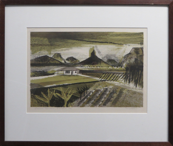
Work on paper - Artwork - Printmaking, Jack, Kenneth, "Glasshouse Mountains, Queensland" by Kenneth Jack, 1961
Kenneth JACK AM MBE RWS, (5 October 1924 – 10 June 2006) Australian watercolour artist Kenneth Jack who specialised in painting the images of an almost forgotten outback life; old mine workings, abandoned ghost towns, decaying farm buildings. He became a professional painter at the age of 39 after giving up his job as senior instructor at the Caulfield Institute of Technology. In 1977 he was elected to The Royal Watercolour Society and in 1982 was awarded the MBE, and the Order of Australia (AM) followed in 1987. Framed three block linocut depicting the Glasshouse Mountains in the Australian State Queensland. Donated through the Australian Gifts Programme by Katherine Littlewood.21/32artwork, artist, kenneth jack, printmaking, glasshouse mountains, queensland, available, linocut -
 Flagstaff Hill Maritime Museum and Village
Photograph - Historical, Port Fairy, Late 19th to early 20th centuries
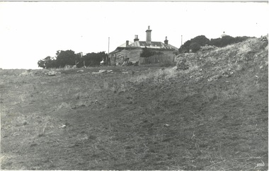
The late 19th to early 20th century stone cottage with weatherboard extensions. From research, it has been determined that the cottage was the Port Fairy (Belfast) Lighthouse Keepers cottage. The dome roof in the background indicates a lighthouse, in which case the cottage would have been the living quarters for a lighthouse keeper and assistant keeper. The narrow poles could have been for signals and antennae. The object on the rock stack looks like a large metal milk can.The photograph shows a typical late 19th to early 20th century cottage, abandoned at dilapidated for many years. Black and white rectangular photograph mounted on card. The image shows a dilapidated stone cottage with an old picket fence. Extending behind the stone cottage are gabled roofs above weatherboard walls. The cottage has corrugated roof sheets of different colours, and four chimneys, three with chimney pots. From research, it has been determined that the cottage was the Port Fairy (Belfast) Lighthouse Keepers cottage. Near the fenceline on the left, a corrugated water tank is positioned below a pipe joined to the roof gutter. Nearby are a timber shed and timber walls or screens. In the background are two tall narrow poles with spheres on top, higher than the cottage, with one pole on each side, the left one attached to the building. A domed roof with a knob on top is on the right behind trees. Several angular shapes appear on the horizon on the left, one almost hidden by the trees. The foreground is rocky and slopes uphill on the right. At the foot of the slope is a stack of closely fitted rocks with an object shaped like a milk can on top and an object to its left that is like an open grid. Handwritten Inscriptions are on the reverse side of the photograph.Pencil on board: " D9 / 200 x 150" Pen on sticker: "52"flagstaff hill maritime museum and village, warrnambool, great ocean road, shipwreck coast, cottage, lighthouse, iron roof, stone building, picket fence, water tank, weatherboard building, 19th century cottage, early 20th century cottage, abandoned cottage, antenna, chimneys, milk can -
 Mission to Seafarers Victoria
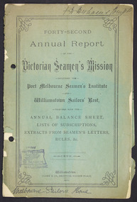
Administrative record (item) - Annual report, Clarke & Co. Printers, Forty-Second Annual Report of the Victorian Seamen's Mission, 1899, 1900
The reports were produced and readily distributed annually to a number of organisational stakeholders and included reports from the Committee, Chaplain, extracts of letters, Ladies auxiliary and a list of subscribers. In the Argus (Melbourne, Vic. : 1848 - 1957), Saturday 24 February 1900, page 15: VICTORIAN SEAMEN'S MISSION The annual meeting of the Victorian Seamen's Mission was held in the institute at Port Melbourne last night. There was a fair attendance, the large proportion being ladies, and the chair was occupied by Sir Frederick Sargood MLC. Mr Hugh R Reid, the president of the institute, was also president. The annual report, which was lead and adopted, stated that the Seamen's Institute at Port Melbourne, and also the Sailors' Rest at Williamstown, had sustained their reputation for usefulness and attractiveness. The attendances had been very large at each place and 114 seamen had taken the pledge at the Port Melbourne Institute. Regreat was felt that owing to the preliminary steps having met with opposition in Parliament the building of the long contemplated additional institute near the Melbourne wharves was deferred but the project had not been abandoned. Large parcels of literature had been distributed gratuitiously among ships' crews and the concerts held for the entertainment of seamen had been very successful. The mission had been in existence for over 40 years. It aimed at promoting the temporal and spiritual welfare of seamen. It had been the means of completely eradicating "crimping" and the sailors' "boarding masters" curie, and otherwise removing many of the abuses which still exist in other ports. The Chairman, in moving the adoption of the report and balance sheet, referred to the great benefits which seamen derived from the institute. He was particularly struck by the fact that during the past year close on 2,000 letters had been written by visiting seamen from the institute namely, 1,720 at Port Melbourne, and 261 at Williamstown. It was also a very note-worthy feature, which perhaps the residents of Williamstown might be able to explain that, whilst out of 49,567 attendances at the Port Melbourne institute 114 had taken the pledge there, there was not a single instance on record of the pledge having been taken at the Sailors' Rest, Williamstown, out of 8,218 attendances. (Laughter) Referring to the projected new institute near the wharves, he was amazed to find that its construction had been, according to the report, orefused by some of the labour members. He did not know the details of the matter, but was of opinion that there was no institution more deserving of the support of labour members than the one advocated. In his opinion, the representatives of labour should disown the action of their delegates in Parliament in this matter. (Cheers ) Selections of vocal and instrumental music were given during the evening.These reports were produced annually and include a number of smaller reports from the Executive Committee, Chaplain and auxiliary. They sometimes included photographs and a list of subscribers and amounts pledged. These reports provide an organisational overview as well as many stories of the people who populated the Mission to Seafarers.Handwritten in ink on top right hand corner: "F T Derham [indecipherable]" Handwritten in ink on bottom left hand corner: "Melbourne Sailors' Home" Cover back page written in black ink: W. Siddley Esq. / 529 Collins Street / Melbourneannual report, 1899, victorian seamen's mission, port melbourne, williamstown, sailors' rest, seamen's mission, mission to seafarers, seamen's institute, sailors' home, f.t. derham, reverend ebenezer james, whc darvall, frederick sargood, hugh r. reid, administrative document-annual report -
 Kew Historical Society Inc
Photograph - Kew City Hall, Ron Setford, 1960
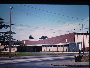
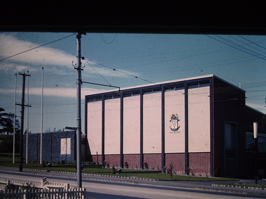
Ron Setford and his wife Grace Setford lived in Tanner Avenue, East Kew, from c.1946 to c.1995. A keen photographer, he recorded the changing face of Kew over a 20 year period. Apart from 30 photographs of built structures and places in Kew dating from 1960 and 1961, 145 of his 35mm colour slides chronicle the development of the Eastern Freeway through the Yarra Valley over a five year period from c.1972 to c.1977. This important collection was donated to the Society by his granddaughter in 2025.This collection of 175 35mm slides is of local and statewide significance, owing to its subject matter, particularly the major development of road transport infrastructure during the 1970s with the construction of the Eastern Freeway. The photographer also took care to annotate and date most of his slides which enable the researcher to pinpoint temporal and spatial locations.The Kew City Hall in Cotham Road, designed by Harold Bartlett, was intended as the initial phase in a scheme to develop an entire civic precinct. This was representative of a widely-held belief, of the immediate post-war era, that a district's civic centre should be precisely that – not just a single grand building for official use, but a dedicated precinct providing a range of community facilities as well as an administrative function. The Kew masterplan was later abandoned. The City Hall was designed to cater for public or official functions. Its interior had a small stage at one end for intimate theatrical productions, a larger stage at the other (with sunken orchestra pit) for musical performances, plus the most up-to-date equipment for live TV transmission."Kew Town Hall"ron setford, photographs -- kew (vic.) -- 1960s, kew town hall -
 Kew Historical Society Inc
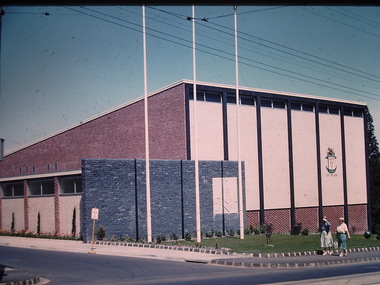
Photograph - Kew City Hall, Ron Setford, 1960
Ron Setford and his wife Grace Setford lived in Tanner Avenue, East Kew, from c.1946 to c.1995. A keen photographer, he recorded the changing face of Kew over a 20 year period. Apart from 30 photographs of built structures and places in Kew dating from 1960 and 1961, 145 of his 35mm colour slides chronicle the development of the Eastern Freeway through the Yarra Valley over a five year period from c.1972 to c.1977. This important collection was donated to the Society by his granddaughter in 2025.This collection of 175 35mm slides is of local and statewide significance, owing to its subject matter, particularly the major development of road transport infrastructure during the 1970s with the construction of the Eastern Freeway. The photographer also took care to annotate and date most of his slides which enable the researcher to pinpoint temporal and spatial locations.The Kew City Hall in Cotham Road, designed by Harold Bartlett, was intended as the initial phase in a scheme to develop an entire civic precinct. This was representative of a widely-held belief, of the immediate post-war era, that a district's civic centre should be precisely that – not just a single grand building for official use, but a dedicated precinct providing a range of community facilities as well as an administrative function. The Kew masterplan was later abandoned. The City Hall was designed to cater for public or official functions. Its interior had a small stage at one end for intimate theatrical productions, a larger stage at the other (with sunken orchestra pit) for musical performances, plus the most up-to-date equipment for live TV transmission.Nilron setford, photographs -- kew (vic.) -- 1960s, kew town hall -
 Kew Historical Society Inc
Photograph - Kew City Hall, Ron Setford, 1960
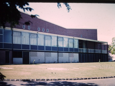
Ron Setford and his wife Grace Setford lived in Tanner Avenue, East Kew, from c.1946 to c.1995. A keen photographer, he recorded the changing face of Kew over a 20 year period. Apart from 30 photographs of built structures and places in Kew dating from 1960 and 1961, 145 of his 35mm colour slides chronicle the development of the Eastern Freeway through the Yarra Valley over a five year period from c.1972 to c.1977. This important collection was donated to the Society by his granddaughter in 2025.This collection of 175 35mm slides is of local and statewide significance, owing to its subject matter, particularly the major development of road transport infrastructure during the 1970s with the construction of the Eastern Freeway. The photographer also took care to annotate and date most of his slides which enable the researcher to pinpoint temporal and spatial locations.The Kew City Hall in Cotham Road, designed by Harold Bartlett, was intended as the initial phase in a scheme to develop an entire civic precinct. This was representative of a widely-held belief, of the immediate post-war era, that a district's civic centre should be precisely that – not just a single grand building for official use, but a dedicated precinct providing a range of community facilities as well as an administrative function. The Kew masterplan was later abandoned. The City Hall was designed to cater for public or official functions. Its interior had a small stage at one end for intimate theatrical productions, a larger stage at the other (with sunken orchestra pit) for musical performances, plus the most up-to-date equipment for live TV transmission.Nilron setford, photographs -- kew (vic.) -- 1960s, kew town hall -
 Ringwood and District Historical Society
Photograph, Opening of clock tower by Mayor W. Mackinlay in August 1928
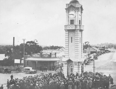
Age (Melbourne, Vic. : 1854 - 1954), Monday 6 August 1928, page 9 ________________________________________ RINGWOOD WAR MEMORIAL CLOCK TOWER UNVEILED A CIVIC CEREMONY. The people of Ringwood have erected a beautiful stone clock tower at a cost of £1797, as a memorial to those who served in the war. The unveiling ceremony was performed by the mayor of Ringwood (Cr. W. Mackinlay) on Saturday. “Bleak conditions with showers intervening prevailed at Ringwood on Saturday afternoon, when the unveiling ceremony of the soldiers' memorial clock tower, performed by the mayor (Cr. W. Mackinlay) took place in the presence of a Iarge and representative gathering. The ceremony was solely a civic one. A majority of members of the local branch of the R.S.S.I.L.A. had wished that Sir John Monash be invited to take a prominent part in the proceedings, but the trustees elected otherwise. The Salvation Army band from Box Hill rendered suitable music, while Sergeant E. P. Taylor (37th Battalion, A.I.F) sounded the Reveille and The Last Post impressively. Among those present were Mr. Edgar, M.L.C., the vicar of Ringwood (Rev. E. E. Robinson), Rev. G. McLaren (Methodist), the memorial trustees (Cr. J. B. McAlpin, Messrs, J. W. Barrett, A. H. Locke, J. A. Williams and A. G. Ashley). The last two mentioned are president and honorary secretary respectively of the local branch of the R.S.A. Soldier delegates from Camberwell and Mitcham were also present. At the outset the mayor said a few words would not be amiss concerning why the memorial had been so long delayed in being erected. In September, 1919, a public committee was formed, with Mr. A. V. Greenwood as chairman, to consider the erection of a suitable memorial to the soldiers. Among the more important suggestions had been the building of a hall and clubrooms on land generously offered by Mr. R. W. Dawes. This project had been abandoned, also the proposed erection of a huge memorial building, at a cost of £5000, on the site of the present town hall. As two years had passed without anything of a definite nature eventuating it was decided to elect five trustees, comprising three citizens and the president and secretary of the Returned Soldiers' Association with full power to act. In all propositions the trustees had been faced with financial difficulties, but about the time of the completion of the plans of the memorial tower Ringwood became a borough, and the new council was appealed to, and provided £500 to make the erection of the memorial possible. The architect, (Mr. H. Norris) had refused to take anything beyond out-of-pocket expenses (£16), while the engineer (Mr. Lucas) had saved a goodly sum by supervising the work. The total funds at the disposal of the trustees, including the council's donation, was, in round figures £1807. The tower complete would cost £1690; honor roll, £77, and fees paid for various designs had amounted to £30. The total expenditure was £1797, leaving a credit balance of £10. Before the unveiling the mayor, in again addressing the citizens, said he deemed it a privilege to perform such a task in connection with so splendid a memorial. The citizens had erected it as an expression of heartfelt gratitude in memory, first of all, of those heroes who gave not only their services, but their lives, when the call came in the common cause of right and liberty, upon which the British Empire was built. This memorial was also the tribute of the citizens in a degree of appreciation to those men who so un-selfishly and ungrudgingly volunteered their services in the Great War. The memorial, while commemorating the glorious deeds of Australian manhood, was not intended, in any sense, as a glorification of war. The memorial would tend to bring to one's mind the blessing of peace in contrast to the curse of hostilities. They were gathered there that afternoon to do honor to all those who volunteered for service to the Great War, but they wished to assure the friends and relatives of those who paid the supreme sacrifice of their sincere sympathy and trust. If ever in the future this fair southern land of ours was threatened by an invader he felt sure that Australian manhood would not hesitate to rally to the call to duty and defend the freedom of their country. Following prayer by Rev. G. McLaren (Methodist), the memorial clock tower was unveiled, the acting mayoress (Mrs. Mackinlay) cutting the cord, after which the making over of the memorial to the borough council took place, the president of the local branch of the R.S.A. (Mr. J. A. Williams) stating he had pleasure in accepting the key on behalf of the trustees. As the council was the permanent governing body the key would be handed back to the mayor, the memorial being given into the safety and custody of the council. During the proceedings the hymns O God, Our Help in Ages Past and Lest We Forget were rendered, the choirs of various denominations joining in the singing. Benediction was pronounced by the vicar of Ringwood (Rev. E. E. Robinson).” Black and white photograph (2 copies- one original mounted on cardboard backing)Written on rear of backing of original: "Opening of clock tower by Mayor W. Mackinlay, 4.8.1928." Written on back of copy" "Mayor Mackinlay dedicating Ringwood clocktower in original position at end of Warrandyte Rd. 1928. Maroondah Hwy on right." -
 Kew Historical Society Inc
Photograph - Kew City Hall, Ron Setford
Ron Setford and his wife Grace Setford lived in Tanner Avenue, East Kew, from c.1946 to c.1995. A keen photographer, he recorded the changing face of Kew over a 20 year period. Apart from 30 photographs of built structures and places in Kew dating from 1960 and 1961, 145 of his 35mm colour slides chronicle the development of the Eastern Freeway through the Yarra Valley over a five year period from c.1972 to c.1977. This important collection was donated to the Society by his granddaughter in 2025.This collection of 175 35mm slides is of local and statewide significance, owing to its subject matter, particularly the major development of road transport infrastructure during the 1970s with the construction of the Eastern Freeway. The photographer also took care to annotate and date most of his slides which enable the researcher to pinpoint temporal and spatial locations.The Kew City Hall in Cotham Road, designed by Harold Bartlett, was intended as the initial phase in a scheme to develop an entire civic precinct. This was representative of a widely-held belief, of the immediate post-war era, that a district's civic centre should be precisely that – not just a single grand building for official use, but a dedicated precinct providing a range of community facilities as well as an administrative function. The Kew masterplan was later abandoned. The City Hall was designed to cater for public or official functions. Its interior had a small stage at one end for intimate theatrical productions, a larger stage at the other (with sunken orchestra pit) for musical performances, plus the most up-to-date equipment for live TV transmission.Nilron setford, photographs -- kew (vic.) -- 1960s -
 Lakes Entrance Historical Society
Photograph - Old Church House, Tambo Upper, Anne Macarthur, 9/10/2010 12:00:00 AM
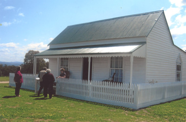
The old Church House served the Bruthen community in 1880s when no longer required it was barged to the New Works area where it became Church and meeting hall. By the time the Entrance work was completed the contractor J R Coate had the building moved to Church Street Lakes Entrance. It was a home for various local families until abandoned then acquired by Val Northrope. After renovation by Val in Lakes Entrance it was moved again to a site beside the Northropes new home at Tambo UpperColour photograph of timber cottage surrounded by picket fence four women at gateway. Cottage situated near Bruthen Victoria. Also eight more colour photographs taken of same house showing various aspects of building. houses, land settlement, churches -
University of Melbourne, Burnley Campus Archives
Document - Files, Burnley Student Association Office, Burnley Student Association Inc, 1983-2002
student association, burnley student association, burnley job service, burnley agricultural college student service, coolboy, stubby holder, billiard table, counselling welfare services survey, correspondence, mark f adams, burnley student enterprise agreement, wages information, constitutional amendsments, mark adams legal advice, submission senate inquiry vsu, student organisations, diary, austudy march, orientation handbook