Showing 56 items
matching administration b
-
 RMIT GSBL Justice Smith Collection
Report, Cairns, B. C, The use of discovery and interrogatories in civil litigation, 1990
ISBN: 0959002987discovery (law) -- australia, interrogatories -- australia -
 University of Melbourne, Burnley Campus Archives
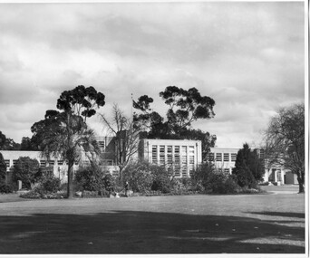
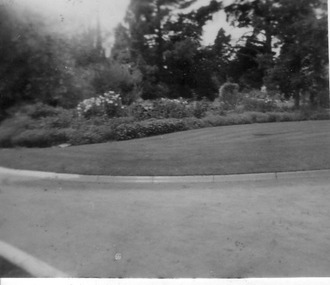
Photograph - Black and white print, Information Branch Victorian Department of Agriculture, Administration Building and Lawnmowing, 1960s
Note by T.H.Kneen 19 November 1991, "The prominent tree centre is Ginkgo biloba. The lawn mower operator could be Pam Moffatt (1965-1967.)"Black and white photograph. View from across the lawn to the East, garden island planting well established. Student with lawnmower.On reverse, "Photograph by Information Branch Victorian Department of Agriculture Ref No. D 1099 B."ginkgo biloba, pam moffatt, lawnmowing, administration building, main building, garden view, student -
 University of Melbourne, Burnley Campus Archives
Album - Black and white and colour slides, Burnley Views, 1947-1955
... of glasshouses and cacti b/w. (17)Administration Building completed... Administration Building before the Pavilion was removed b/w. (61) As (60 ...Contributor: T.H. KneenCardboard box of 108 35mm glass slides in metal frames made by "Gnome." Box labelled "Burnley Gardens Slides." Also 16 unused slides (1) Swan Street entrance c. (2) Orchid? b/w. (3) Nursery b/w. (4) Pasture area with man working b/w. (5) Draught horse working in the Orchard b/w. (6) Crop of corn in the Orchard c. (7) Magnolia c. (Magnolia x soulangeana). (8) Display of orange flowers c. (9) Lemon tree in the Orchard c. (10) Sign advertising 'Fruit Tree Pruning Demonstarion Sat. 2nd July (1949) c. (11) Jersey cow c. (12) Rock Point c. (13) Dahlias in the Orchard c. (14) Foundation Stone '28th August, 1946' c. (15) Felled Cypress tree 1951 b/w. (16) School truck in front of glasshouses and cacti b/w. (17)Administration Building completed but surrounded by rubble C.1949 c. (18) Plant Research Institute c. (19) Inside a glasshouse. c. (20) Administration Building c. (21) Group of female students dressed up for a function c. (22) Solenostemon (Syn. Coleus) in a glasshouse. (23, 24)Stock Matthiola incana. (25) Blossom in the Orchard c. (26) Orchard c. (27) Picking fruit in the Orchard c. (28) 2 female students holdong large bunches of poppies c. (29) Flowers growing in the Orchard c. (30) House - not Burnley c. (31) Students on an excursion c. (32) Staff member with Gladioli c. (33) Garden view - not Burnley? c. (34) Administration Building c. (35) Roses c. (36) Flowers in the Orchard c. (37) Draught horse working in the Orchard c. (38) Staff member amongst flowers in the Orchard c. (39) Garden view c. ((40) Blossom in the Orchard c. (41) Orchard c. (42) Flowers inside glasshouse c. (43) Mesembryanthemums in pots possibly in the nursery c. (44) Tree b/w. (45) Garden bed c. (46) Sign, 'Agrostology Branch, pasture Plant Research Field,' c. (47) Path to Principal's Residence c. (48) Irrigation in the Orchard b/w. (49) Cactus flowers b/w. (50) Garden view with T.H. Kneen children playing c. (51) (52) Cinerarias (now Pericallis x hybrida) in pots c. (53) Temporary building where the Grey Garden is now b/w. (54) Garden view b/w. (55) Unknown building b/w. (56) Person pruning in the Orchard c. (57) Students working in the Orchard c. (58) Swan Street with recently completed rock wall constructed by the Public Works Department b/w. (59) Lagoon paddock b/w. (60,62) Pavilion and new Administration Building before the Pavilion was removed b/w. (61) As (60) but viewed from a different direction c. (63) Plant c. (64) View through a window on the stairs in the Administration Building c. (65) Plant c. (66) Garden view of trees c. (67) Garden View b/w. (68) Blossom tree c. (69 )Garden view along path to Principal's Residence c. (70) Lagoon Paddock c. (71) Lagoon Paddock with cows b/w. (72) Inside a glasshouse b/w. (73) Entrance sign- Department of Agriculture Burnley Gardens, School of Horticulture & Primary Agriculture, Plant Research laboratory, Agrostology Branch, Fruit Preserving Branch c. (74) Plant Research Laboratory b/w. (75) Students on an excursion c. (76) Glasshouses b/w. (77) Garden view b/w. (78) Kniphophia c. (79) Hibiscus c. (80) Garden view c. (81) Dairy, Silo and dog b/w. (82) Irrigation in then Orchard b/w. (83) Garden view with magnolia c. (84) Flower plots in the Orchard c. (85) Pruning demonstration b/w. (86) Administration Building under construction c. (87) Rock Point c. (88) Mrs Kneen and Magnolia c. (89) Glasshouses c. (90) Sequoia sempervirens b/w. (91) Inside Administration Building c. (92) Luffmann Ponds b/w. (93) Sequoia sempervirend, Mrs Kneen and child c. (94) Garden bed in front of Sequoian sempervirens c. (95) Principals Residence b/w. (96) Poultry pens b/w. 1947 (97) Principals Residence b/w. (98) Student picking fruit from netted tree b/w. (99) Rock Point and Long Border c. (100) Administration Building under construction c. (101) Greenhouse b/w. (102) Rock Point c. (103) Flowers in the Orchard c. (104) Waterlilies in the Pond c. (105) Blossom tree c. (106) Hilda Kirkhope Rockery c. (107) Long Border c. (108) Plant Research Institute with flower border along drive c.burnley gardens, flower, nursery, pasture, draught horse, orchard, crops, magnolia, chicken coops, egg laying competition -
 University of Melbourne, Burnley Campus Archives
Album - Colour slides, Burnley Trees, 1970-1985
29 slides of trees at Burnley. Some labelled. 1. Students and the climbing tree in the Shady Walk Araucaria bidwillii Nov 1985 . 2.3 slides "Oak B. Gdns before isolation" Apr 1970. 3.2 slides "Oak B. Gdns after isolation" May 1970. 4. Garden view of bed from Shady Walk towards Administration Building Sep 1985. trees, burnley, students, tree climbing, shady walk, araucaria, oak, burnley gardens, administration building -
 University of Melbourne, Burnley Campus Archives
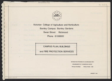
Plan, Campus Plan, Buildings and Fire Protection Services
site plan, buildings, administration building, plant science laboratories, quad, library, student amenities building, engineering, urban horticulture, nursery -
 City of Greater Bendigo - Civic Collection
Photograph - Portrait of Councillor Keck, W H Robinson, c 1913
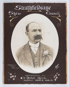
The district of Strathfieldsaye was proclaimed in 1861 and named a Shire on the 17th September in 1866. It remained a shire until amalgamation in 1994 when it became part of the City of Greater Bendigo. The shire was located 8 km to the south- east of Bendigo and covered an area of 601 square kilometres and extended from the Calder Highway to the Coliban and Campaspe Rivers. The shire's administration centre was in Strathfieldsaye until 1972 when new offices were opened in Kennington.Framed black and white head and shoulder portrait of Councillor Keck with hand coloured and drawn detail. Profile slightly to right with walrus moustache. Cut oval brown mount decorated with text and flowers. Hand written title top and lower centre.Strathfieldsaye / Shire Council / W.H. Robinson / Photo / Bendigo / J.H.E Gribbs / Presented by / Cr Herbert Keck / President 1903-4. 1912-13.shire of strathfieldsaye, councillor keck, strathfieldsaye shire council, president of strathfieldsaye shire -
 City of Greater Bendigo - Civic Collection
Photograph - Councillor group portrait, W H Robinson, Strathfieldsaye Shire Council, 1909
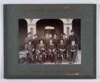
The district of Strathfieldsaye was proclaimed in 1861 and named a Shire on the 17th September in 1866. It remained a shire until amalgamation in 1994 when it became part of the City of Greater Bendigo. The shire was located 8 km to the south- east of Bendigo and covered an area of 601 square kilometres and extended from the Calder Highway to the Coliban and Campaspe Rivers. The shire's administration centre was in Strathfieldsaye until 1972 when new offices were opened in Kennington.Photographic group portrait of eleven Strathfieldsaye Shire Councillors in front of the Strathfieldsaye Shire Hall. Five men are seated and six standing with one man standing further in back ground on the building's verandah. Photograph is attached directly to green mount card and framed. Gold lettering on mount.Strathfieldsaye Shire Councillors / R. B. Brennan (Sec.) W. J. Lowdes S. Doak M. Burns () N Condon B. Code (Inspector) / WH Robinson Photo Bendigo / T Somerville / W. I. Long / Fred Osborne (President) H Keck / W Dresler / With the President's (Cr. Fred Osborne) Compliments / September 23rd, 1909shire of strathfieldsaye, strathfieldsaye shire council, president of strathfieldsaye shire, strathfieldsaye shire hall -
 City of Greater Bendigo - Civic Collection
Photograph - Portrait of Councillor Michael Condon, W H Robinson
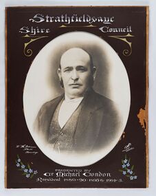
The district of Strathfieldsaye was proclaimed in 1861 and named a Shire on the 17th September in 1866. It remained a shire until amalgamation in 1994 when it became part of the City of Greater Bendigo. The shire was located 8 km to the south- east of Bendigo and covered an area of 601 square kilometres and extended from the Calder Highway to the Coliban and Campaspe Rivers. The shire's administration centre was in Strathfieldsaye until 1972 when new offices were opened in KenningtonFramed black and white head and shoulder portrait of Councillor Condon with hand coloured and drawn detail. Profile slightly to left. No facial hair. Cut oval brown mount decorated with text, scrolls and flowers. Hand written title top and lower centre.Strathfieldsaye / Shire / Council / W. H. Robinson / Photo / Bendigo / JMB Gribble / Presented by / Cr Michael Condon / President 1889 - 90. 1895-6. 1904 - 5strathfieldsaye shire council, president of strathfieldsaye shire, councillor condon -
 City of Greater Bendigo - Civic Collection
Photograph - Portrait of Councillor Doak, W H Robinson
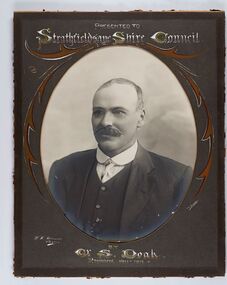
The district of Strathfieldsaye was proclaimed in 1861 and named a Shire on the 17th September in 1866. It remained a shire until amalgamation in 1994 when it became part of the City of Greater Bendigo. The shire was located 8 km to the south- east of Bendigo and covered an area of 601 square kilometres and extended from the Calder Highway to the Coliban and Campaspe Rivers. The shire's administration centre was in Strathfieldsaye until 1972 when new offices were opened in Kennington.Framed black and white head and shoulder portrait of Councillor Doak with hand coloured and drawn detail. Left facing profile with walrus moustache. Cut oval brown mount decorated with text and scrolls. Hand written title top and lower centre.Presented to / Strathfieldsaye Shire Council / W. H. Robinson / Photo / JMB Gribble / by Cr S. Doak / President 1911 - 1912strathfieldsaye shire council, president of strathfieldsaye shire, councillor doak -
 City of Greater Bendigo - Civic Collection
Photograph - Portrait of Councillor Sibley, W H Robinson
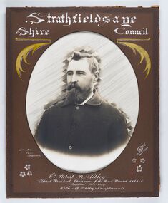
The district of Strathfieldsaye was proclaimed in 1861 and named a Shire on the 17th September in 1866. It remained a shire until amalgamation in 1994 when it became part of the City of Greater Bendigo. The shire was located 8 km to the south- east of Bendigo and covered an area of 601 square kilometres and extended from the Calder Highway to the Coliban and Campaspe Rivers. The shire's administration centre was in Strathfieldsaye until 1972 when new offices were opened in KenningtonFramed black and white head and shoulder portrait of Councillor Sibley with hand coloured and drawn detail. Profile slightly to left with walrus moustache and beard. Cut oval brown mount decorated with text, flowers and scrolls. Hand written title top and lower centre.Strathfieldsaye / Shire Council / W m Robinson / Photo / Bendigo / J N B Gribble / Cr Robert R Sibley / First President Chairman of the Road Board 1865 - 5 / President 1866 - 1869 / With Mrs Sibley's Complimentsstrathfieldsaye shire council, councillor sibley, president of strathfieldsaye shire -
 City of Greater Bendigo - Civic Collection
Photograph - Portrait of Councillor Brennan, W H Robinson
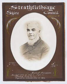
The district of Strathfieldsaye was proclaimed in 1861 and named a Shire on the 17th September in 1866. It remained a shire until amalgamation in 1994 when it became part of the City of Greater Bendigo. The shire was located 8 km to the south- east of Bendigo and covered an area of 601 square kilometres and extended from the Calder Highway to the Coliban and Campaspe Rivers. The shire's administration centre was in Strathfieldsaye until 1972 when new offices were opened in Kennington. Councillor Michael Brennan held roles of Shire Secretary and Clark of Works until around 1998 when his son R. B. Brennan was appointed Assistant Secretary and then Shire Secretary to assist his father with the work load during his later years. Michael Brennan remained Clerk of Works until his death at which time his son was appointed to the duties previously held by his father. Framed black and white head and shoulder portrait of Councillor Brennan with hand coloured and drawn detail. Profile to left. Cut oval brown mount decorated with text and flowers. Hand written title top and lower centreStrathfieldsaye / Shire Council / W H Robinson / Photo / Bendigo / J H B Gribble / Michael Brennan / President 1869 - 70. 1871 - 2. 1872 - 3 / Secretary 1882 to 1900 / Engineer & Valuator 1882 to 1902strathfieldsaye shire council, councillor brennan, president of strathfieldsaye shire -
 City of Greater Bendigo - Civic Collection
Photograph - Portrait of Shire Secretary Brennan, Unknown
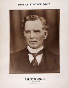
The district of Strathfieldsaye was proclaimed in 1861 and named a Shire on the 17th September in 1866. It remained a shire until amalgamation in 1994 when it became part of the City of Greater Bendigo. The Shire was located 8 km to the south- east of Bendigo and covered an area of 601 square kilometres and extended from the Calder Highway to the Coliban and Campaspe Rivers. The shire's administration centre was in Strathfieldsaye until 1972 when new offices were opened in Kennington. Secretary Brennan, son of Councillor M. Brennan was appointed after his fathers death to the role and according to the The Bendigo Independent was in the role in 1917. See References.Framed black and white head and shoulder portrait of Councillor Brennan. Profile slightly to left. Cut rectangle cream mount. Hand written title top and lower centre. Shire of Strathfieldsaye / R. B. Brennan, Esq / Secretarystrathfieldsaye shire council, secretary strathfieldsaye shire -
 City of Greater Bendigo - Civic Collection
Work on paper - Architectural Drawing, City of Bendigo, Public Offices Bendigo, 23 November 1928
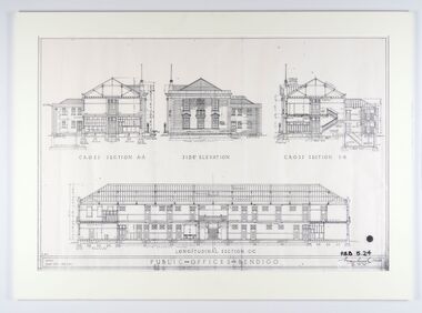
Mounted plan drawings for Public Offices in Bendigo.Cross Section A-A / Side Elevation / Cross Section B-B / Longitudinal Section C-C / R.M.B. / Scale: Eight feet - One Inch / PUBLIC OFFICES BENDIGO ? P.B.B. 5.24 / (signature) / Chief Architect / 23.11.24city of greater bendigo administration item -
 University of Melbourne, Burnley Campus Archives
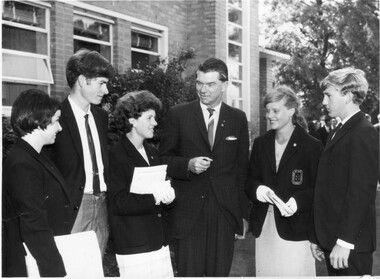
Photograph - Black and white print, Publicity Branch Victorian Department of Agriculture, Graduation Day Mid 1960's, 1970-1980
2 very similar black and white photographs. 5 students wearing blazers, with a man (Dept. of Agriculture?) standing in front of the Administration Building. It appears to be Graduation Day.On reverse, "Photograph by Publicity Branch Victorian Department Of Agriculture Ref. No. D826A and B."students, blazers, administration building, graduation day, publicity, dept of agriculture -
 University of Melbourne, Burnley Campus Archives
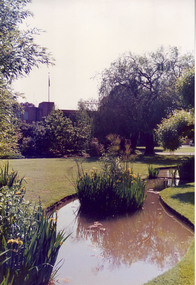
Photograph - Colour print, Luffmann Ponds, c. 1990
Colour photograph of the Luffmann Ponds. Irises in flower. Administration Building in the background.administration building, luffamn ponds, c b luffmann, irises, lily ponds -
 Falls Creek Historical Society
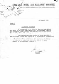
Document - Circular - Falls Creek Ski School Rule Pursuant To Clause 5 (B)(V)
Bob (Herman) Hymans (a former member of the Royal Netherlands Navy) was born in Bloemendaal, Holland on 30th September 1922. During World War II he fought against the Japanese in the Dutch East Indies (now Indonesia) and was imprisoned in Changi and on the Burma Railway. After gaining qualifications as a Ski Instructor, Bob arrived in Falls Creek in July 1950. Working as an Instructor and Supervisor at Bogong Lodge, Bob decided his future was in accommodation. He was successful in negotiating an indenture for land from the State Electricity Commission (SEC). It took Bob two years to build his Grand Coeur Chalet but, tragically, it was burned down in August 1961. Bob also built the first Chairlift in Australia. This was a single chairlift and the structure was built from wooden electricity poles. He was constantly full of new ideas and proposals for the village. Bob Hymans died on 7th July 2007. This Collection of documents and letters tells the story of Bob's endeavours to develop Falls Creek into the ski village it is today.This item is significant because it documents actions taken by the Falls Creek Tourist Area Management Committee in their role overseeing the Tourist Area.A circular from the Management Committee repeating rule which states that no person can give skiing instruction for money without the prior approval of the Committee.falls creek tourist area management committee, bob hymans, falls creek administration -
 Falls Creek Historical Society
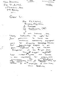
Letter - FCTAMC Building Regulation (A) General Earthmoving (B)
Bob (Herman) Hymans (a former member of the Royal Netherlands Navy) was born in Bloemendaal, Holland on 30th September 1922. During World War II he fought against the Japanese in the Dutch East Indies (now Indonesia) and was imprisoned in Changi and on the Burma Railway. After gaining qualifications as a Ski Instructor, Bob arrived in Falls Creek in July 1950. Working as an Instructor and Supervisor at Bogong Lodge, Bob decided his future was in accommodation. He was successful in negotiating an indenture for land from the State Electricity Commission (SEC). It took Bob two years to build his Grand Coeur Chalet but, tragically, it was burned down in August 1961. Bob also built the first Chairlift in Australia. This was a single chairlift and the structure was built from wooden electricity poles. He was constantly full of new ideas and proposals for the village. Bob Hymans died on 7th July 2007. This Collection of documents and letters tells the story of Bob's endeavours to develop Falls Creek into the ski village it is today.This letter is significant because it reflects the relationship between Bob Hymans and the Management Committee.A handwritten letter from Bob Hymans to the Falls Creek Tourist Area Management Committee requesting permission to use mechanical earth moving equipment to did trenches for sewerage disposal.falls creek tourist area management committee, bob hymans, falls creek administration -
 Falls Creek Historical Society
Letter - Chairlift Proposal
Bob (Herman) Hymans (a former member of the Royal Netherlands Navy) was born in Bloemendaal, Holland on 30th September 1922. During World War II he fought against the Japanese in the Dutch East Indies (now Indonesia) and was imprisoned in Changi and on the Burma Railway. After gaining qualifications as a Ski Instructor, Bob arrived in Falls Creek in July 1950. Working as an Instructor and Supervisor at Bogong Lodge, Bob decided his future was in accommodation. He was successful in negotiating an indenture for land from the State Electricity Commission (SEC). It took Bob two years to build his Grand Coeur Chalet but, tragically, it was burned down in August 1961. Bob also built the first Chairlift in Australia. This was a single chairlift and the structure was built from wooden electricity poles. He was constantly full of new ideas and proposals for the village. Bob Hymans died on 7th July 2007. This Collection of documents and letters tells the story of Bob's endeavours to develop Falls Creek into the ski village it is today.This item is significant because it documents proposals put forward by Bob Hymans to develop facilities in the Falls Creek Tourist Area.This letter to the Falls Creek Tourist Area Management Committee contains Mr Hymans' application to establish one or the other of two proposals at Falls Creek. Proposal A was for the installation and operation of a double Chairlift with drive station at the top as well as the establishment and operation of an observation lounge and restaurant facilities at the top station. Proposal B was for the establishment and operation of an accommodation building. In either scheme, all patrons of the restaurant would have a panoramic view of the Valley Chairlift and every skiing slope through uninterrupted glass walls. Information regarding structure details and tariffs is included. The capital expenditure was expected to exceed £220.000 for Scheme A or £45,000 for Scheme B. Mr. Hymans proposed that construction would be scheduled for completion by the commencement of the 1963 snow season.falls creek tourist area management committee, bob hymans, falls creek administration -
 University of Melbourne, Burnley Campus Archives
Photograph - Black and white print, Information Branch Victorian Department of Agriculture, Group of Diploma III Students 1973, 1973
Black and white group photograph of Diploma III Students 1973 seated and standing on the Lawn in front of the Administration Building. (a) 2 copies. (b) Slightly different pose. Ref. No. 5(a) On reverse of 1 copy, "Photograph by Information Branch Victorian Department of Agriculture Ref. No. 4.diploma iii, students, 1973, diploma iii students 1973 -
University of Melbourne, Burnley Campus Archives
Plan, New School of Primary Agriculture & Horticulture Burnley Gardens, 1945
Photocopy of Plan of the Administration Building by the Chief Architect dated 26.9.45. Scale 1/8 inch - 1 foot. Photocopy reduced in size from original. (1) Ground Floor and First Floor Plans. (2) West Elevation, Longitudinal Section 'B-B' and East Front Elevation. (3) Flat Roof, Library and Herbarium. (4) Common Room and Assembly Hall. Originally in the Burnley Archives. Property and Service now have the original and gave the reduced size photocopy to the Archives. Hard to read now.burnley gardens, school of primary agriculture and horticulture -
Federation University Historical Collection
Book - Report, Ballarat School of Mines Conservation Management Plan, 2016, 2016
The Ballarat School of Mines was the first school of mines in Australasia, and is a predecessor institution of Federation University Australia.CD-ROM of the SMB Campus Conservation Management plan, and a printout of the 390 page Draft report on the Federation University SMB Campus. Contents include: Establishment of the Wesleyan church Reserve Selection of a Site for the Ballarat Gaol and Court House Building the Court of Mines The Gaol Culvert The Ballarat School of Mines Establishment Ballarat iron Workers' Association Ballarat Technical Art School Ballarat School of Mines Museum Acquisition of Lewin's Land The Ballarat School of Mines site in c1970 Master Planning Flecknoe Biulding The Ballarat School of Mines in 1988 Architectects Caselli, Figgus, Molloy and Smith. Public Work Department Architects Ballarat School of Mines Botanical Garden Former Ballarat Junior Technical School Administration Building - Building A W.J. Gribble Building (Ballarat Technical Art School) - Building B Old Chemistry Building Building C Amenities Building, Governor's Quarters, Gaol Gatehouse and Watch Tower and Gaol Walls - Building D Courthouse Theatre (Former Ballarat Supreme Court) - Building F A.W. Steane Building (Former Ballarat Junior Technical School) - Building J Flecknoe Building and E.J. Barker Building (Building N) Old Plumbing Building - Builidng ) Unistyle Haridressing Building (Formerly Ballarat School of Mines Museum and Wesleyan Church) - Building P david rowe, wendy jacobs, ballarat school of mines conservation management plan, ballarat school of mines, buildings, wesleyan church reserve, former ballarat gaol, court of mines, circuit courthouse, gal culvert, ballarat school of mines museum, ballarat technical art school, x-rays, ballarat junior technical school, motor mechanics, wool classing, former governor's quarters, library, flecknoe building, former supreme court, architects, henry richards caselli, figgis, molloy and smith, public work department architects, ballarat school of mines botanic garden, former ballarat junior technical school commemorative gardem, w.j. gribble building, old chemistry building, amenities building, former warden's quarters, courthouse theatre, a.w. steane building, old plumbing building, unistyle hairdressing building, former ballarat post office, post office gallery, former ballarat government offices, cmp, conservation management plan, ballarat school of mines campus, smb campus -
 Bendigo Military Museum
Document - Disbandment of Army Survey Regiment Planning 1995, Army Survey Regiment, Bendigo, December 1995
.1 Disbandment of Army Survey Regiment (ASR) Planning19 May 1995. Reference A - DCGS Directive /95 Implementation of the In-house option for the provision of Digital Topographic Support to the ADF. Reference B - Army Svy Regt 623-11-02 262/95 ADF Contingency Capability for the Provision of Topographic Data during the transition ASR to ATSE dated 12 May 1995. Reference A directs the ASR to be disbanded by 1 Dec 1996. Planning for the Disbandment is to consist of the following: Phase 1 - Development of Draft Outline Plan (1) Determine the Aim, Limitations and factors to be considered in the appreciation into the disbandment, (2) Conduct an appreciation to determine the best course of action, (3) Develop an Outline Plan for the Best Course of Action. (4) Brief DSVY-A and staff on the proposed Outline Plan. Phase 2 - Review of the Outline Plan by DSVY-A and issue further guidance. Phase 3 - Develop the Detailed plan including project management strategy. The disbandment is to achieve the smooth transition of operational responsibility to ATSE. The responsibility and resources to maintain the Minimum Operational Capability outlined in Reference B is to be formally passed to ATSE prior to disbandment. Proposed timings: Phase 1 completed by 1 Jun 95, Phase 2 completed by 15 Jun 95, Phase 3 complete d by 30 Jun 95, Disbandment completed by no later than 1 Dec 96 (Executive Order). All postings, administration and stores and equipment returns are to be completed by this date. .2 Disbandment of Army Survey Regiment Planning Report 26 May 1995 - Develop possible courses of action for the disbandment of ASR with reference to Technical, Historical and Union Issues by 6 Jun 95. .3 Disbandment of Army Survey Regiment Disbandment Team 26 May 1995 - Allocation of Team Members and responsibilities. .4 Disbandment of Army Survey Regiment May 1995 - Minimum Contingency Technical Equipment List for transition to ATSE. .5 Disbandment of Army Survey Regiment Plan 23 Aug 1995 - During the transition period (1 Jul 95 - 1 Dec 1996) leading to the full implementation of the Preferred In House Option (PIHO) Army Svy Regt and ATSE will at all times operate concurrently whilst Army Svy Regt scales down production and progressively transfers all technical functions to ATSE. Army Svy Regt will continue programmed production activities at best endeavor until declared operationally ineffective. During the transition to ATSE a contingency mapping capability is to be maintained. .6 Directorate of Survey - Army Commercial Support Program Digital Topographic Support to the ADF In-House Option Directive Dec 95. This directive defines the CSP contract management arrangements between the contract Administrator (DSVY-A) and the Contractor (ATSE) for the implementation and operation of the IHO for digital Topographic support to the ADF. .1 Disbandment of Army Survey Regiment Planning19 May 1995 - A4 paper clipped document, 4 x hole punched, 21 pages, diagrams and typed and hand written. .2 Disbandment of Army Survey Regiment Planning Report 26 May 1995 - A4 paper stapled document, 4 x hole punched, 9 pages, diagrams and typed and hand written. .3 Disbandment of Army Survey Regiment Disbandment Team 26 May 1995 - A4 paper stapled document, 4 x hole punched, 2 pages, typed. .4 Disbandment of Army Survey Regiment May 1995 - Minimum Contingency Technical Equipment for transition. A4 paper stapled document, 4 x hole punched, 2 pages, typed. .5 Disbandment of Army Survey Regiment Plan 23 Aug 1995 - A4 paper stapled document, 4 x hole punched, 10 pages, diagrams and typed. .6 Directorate of Survey - Army Commercial Support Program Digital Topographic Support to the ADF In-House Option Directive Dec 95. A4 paper clipped document, 4 x hole punched, 16 pages, diagrams and typed, hand written notes. royal australian survey corps, rasvy, fortuna, army survey regiment, army svy regt, atse, asr -
 Kiewa Valley Historical Society
Photo - Tawonga District General Hospital
The hospital was transported from Bonegilla (ex-army hospital ward) and began operations in 1949. It was located at the corner of Ryder's Lane and the Kiewa Valley Highway opposite the Bogong pub. In 1961, the hospital was relocated to the centre of the Mt Beauty town in the former SEC Administration buildingThe Tawonga District General Hospital was created in the late 1940s as the local population grew as a result of the SECV constructing the KHES and the town of Mt Beauty. Prior to this, the nearest hospital was at Yackandandah and medical care was provided by medical practitioners in Mt Beauty.B & W postcard photo showing Tawonga District General Hospital in front of mountains and below a cloudy sky.Printed in white at the bottom left side "Tawonga District General Hospital" and on back "Postcard / A Genuine Photograph"tawonga hospital, medical care, mt beauty hospital., tawonga district general hospital -
 National Vietnam Veterans Museum (NVVM)
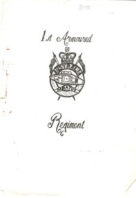
Booklet, Australian Army, Australian Army: Copies of 1st Armoured Regiment Administration and Logistics in the Field: APC Troop and other military documents, 1971
Copies of 1st Armourd Regiment admistration and logistics in the field. There are several part sections of the booklets. Some of these are held togeher with metal staples, some are loose and one is held together with a metal slide.booklet, 1st armoured regiment, b squadron, 3 cav regt, small arms, crew drills -
 University of Melbourne, Burnley Campus Archives
Album - Black and white photographs, certificate and reports, Justine Curry, Justine Curry (Mitchelson) Album Burnley Horticultural College Vic. 1953-1954, 1953-1954
Donated by Justine Curry (nee Mitchelson) (1954) for the 1991 Centenary. Also includes photocopy of her Certificate of Competency and her Reports for 1953 and 1954. Note (5) Frame for School Bell which used to be on top of the Pavilion is on the ground outside the Administration Building, later installed above the door.Photograph album collection of 61 b/w photographs of different sizes dated 1953-1954, some labelled. Were attached to magnetic pages but have come loose and have been transferred to plastic pockets. Also photocopy of work experience. A newspaper cutting. Certificate of Competency. Reports.Labelled, "Justine Curry 4/11A Margate Pd., Margate, Qld 4020." justine curry (nee mitchelson), administration building, luffmann ponds, yarra river, helen eastman, orchard, wilson's promontory, lloyd davies, mr kneen, students, e. b. littlejohn, jennifer edwards, botanic gardens melbourne, cricket, student groups, certificate of competency, school report, justine curry, justine mitchelson, t h kneen, luffman ponds, lily ponds, royal botanic gardens, ann spruzen, teena, garden views, school bell, orchard gates, orchard border, wilson's promontory camp, mervyn, boys changing room, john rittinger, barb mckay, carmel devaney, marie-louise leng, john sutherland -
 Geoffrey Kaye Museum of Anaesthetic History
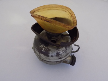
Equipment - Inhaler, Hewitt, George Barth & Co. Ltd, c. 1895
Sir Frederic W. Hewitt (1857-1916), an accomplished and well respected English anesthesiologist, was an expert in the function and use of the Clover Ether Inhaler. In 1901, Hewitt described his modification of the Clover Inhaler. Often referred to as the Hewitt Wide-Bore Inhaler, Dr. Hewitt introduced changes in order to make it easier to breathe through the device and improve the ventilation of oxygen and carbon dioxide. In 1901, Hewitt was recruited to anesthetize King Edward VII for emergency abdominal surgery. This was just a day or so before the new King was to be coronated. He recovered well, and Hewitt became the first anesthesiologist ever to be knighted. (Source: Wood Library Museum)Tall black round topped box with brass hooks at the sides and brass hinges at rear. There is a brown fabric handle on the top. The box has red padding inside the lid and red lining inside the base and sides. There is a round section in the base of the box for holding the round clear glass bottle for ether. There is also a ellipse-shaped metal inhaler on small metal base with a thin metal handle and pipe with bakelite plug attached via a small metal chain. A brown mask is made of brown leather and celluloid which is connected to the inhaler. There is a metal ether measure for pouring the ether.On notecard in box: (B) HEWITT'S INHALER 1895, MADE BY GEO. BARTH & CO LTD., ADVERTISED AS THE SOLE MAKERS OF THE INHALER AND RECOGNISED BY HEWITT IN HIS TEXT BOOK - ANAESTHETICS AND THEIR ADMINISTRATION - AS THE MAKER OF HIS INHALER. / GIVEN BY DR. E.S. HOLLOWAY IN 1951, WHO ACQUIRED MUCH OF HOWARD JONES' EQUIPMENT AFTER THE LATTER'S DEATH. Stamped on underside of glass bottle in a circle: WUBW [illegible] Blue sticker on inhaler: O.2.13. Printed on inhaler under handle: Geo Barth [illegible] / SOL [illegible] Printed on body of inhaler: Full Printed on body of inhaler: 1/2 Printed on inside of leather mask: F35hewitt, sir frederic, jones, howard, inhaler, geo. barth & co. ltd., ether