Showing 2553 items
matching aerials
-
 St Kilda Historical Society
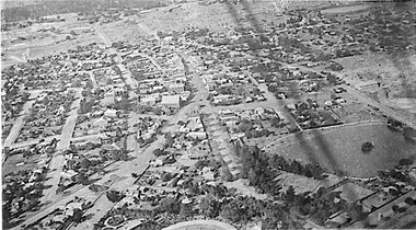
Photograph - Photo map, 11/01/1968
One of a series of photo-maps produced for the Department of Crown Lands and Survey (1857-1983). For correlation with a current map, and access to other historical photo maps of Victoria, see the Historic Photo-Maps Index published by the Department of Environment, Land, Water and Planning at https://services.land.vic.gov.au/DELWPmaps/historical-photomaps/Black and white aerial photographVic 2132 State Aerial Survey Melbourne 1968 Proj. Run 29E 11.1.68 5100 ASL 194elwood, elwood beach, elwood park, elsternwick park, ripponlea, elwood canal, balaclava, st kilda, 1968 -
 St Kilda Historical Society
Photograph - Photo map, 11/01/1968
One of a series of photo-maps produced for the Department of Crown Lands and Survey (1857-1983). For correlation with a current map, and access to other historical photo maps of Victoria, see the Historic Photo-Maps Index published by the Department of Environment, Land, Water and Planning at https://services.land.vic.gov.au/DELWPmaps/historical-photomaps/Black and white aerial photographVic 2132 State Aerial Survey Melbourne 1968 Proj. Run 29E 11.1.68 5100 ASL 196elwood, elwood park, elwood canal, elwood beach, st kilda marina, mc moran reserve, point ormond, 1968 -
 Glenelg Shire Council Cultural Collection
Postcard - Postcard - Portland Harbour, c. 1970
Coloured photo postcard, serrated edge. Aerial view of Portland and harbour, 1970sBack: Maker details. 'Portland Vic, Aerial view of Portland Harbour'postcard, aerial view of portland harbour -
Glenelg Shire Council Cultural Collection
Photograph, c. 1967
Port of Portland Authority archives On 19 November 1960, the Portland Harbour Trust was officially opened by His Excellency, The Governor of Victoria, Sir Dallas Brooks, in front of thousands of onlookers. It was one of the largest concentration of Premiers, Statesmen, industrial and civic leaders ever to attend an event outside of an Australian capital city. Today, Port of Portland is a busy modern port, handling in excess of $2 billion in trade. One of Victoria’s four major shipping ports, it handles bulk cargoes such as plantation woodchips and logs, grain, aluminium products, mineral sands, fertiliser, livestock and wind tower components.This forms part of the archives of the Port of Portland which were donated to the Glenelg Shire Cultural Collection by the Port of Portland. The collection documents the growth and significance of the Port of Portland.Back: Aerial view of section of Port and its surroundsport of portland, henty park, portland botanic gardens -
 Port Fairy Historical Society Museum and Archives
Photograph
Aerial-Port Fairy 1972Coloured aerial photograph aerial, moyne river, douglas house, railway, water tower, traffic bridge, pedestrian bridge -
 Port Fairy Historical Society Museum and Archives
Photograph
Aerial view of Port Fairy WestColoured aerial photographsand hill cemetery, water tower, west -
Glenelg Shire Council Cultural Collection
Photograph - Photograph - land reclamation, 1959
Port of Portland Authority ArchivesFront: Canal and Reclamation. Aerial view west November 1959 - typed.port of portland archives, land reclamation, canal, botanic gardens -
Tatura Irrigation & Wartime Camps Museum
Photograph, Aerial of Tatura 1930, 1930
Early aerial photograph of township of Tatura. Main buildings and street can be seen. Copied by W. Purcell. Original held by donor A. Hampton.Black and white photograph taken from a small plane of township of Taturaon back: aerial photo of Tatura 1930. -
Glenelg Shire Council Cultural Collection
Postcard - Postcard - Nelson, Victoria, n.d
Coloured photo postcard, aerial view of Nelson, Victoria, showing the bridge, township and river mouth. Rose Series De Luxe colorview NO 1213Back: Maker details. 'Aerial view of Nelson Victoria'postcard, nelson -
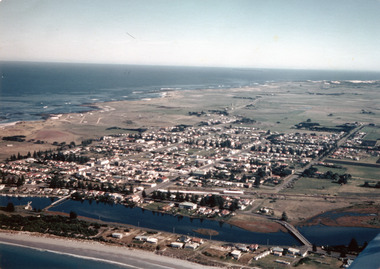
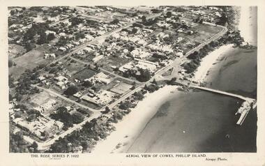 Phillip Island and District Historical Society Inc.
Photograph - Post Card, Unknown
Donated by Stan McFee from the Keith McIlwraith Collection.Black & White postcard showing an aerial view of Cowes Town Centre, beach and pier."The Rose Series P. 1022" "Aerial view of Cowes, Phillip Island." "Airspy Photo".cowes phillip island, cowes foreshore and pier, phillip island, stan mcfee, keith mcilwraith collection -
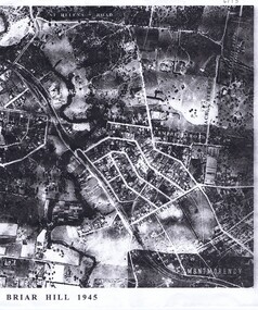 Greensborough Historical Society
Aerial Photograph, Briar Hill 1945, 1945_
Aerial survey photograph of Briar Hill area produced in 19452 photocopies of aerial surveysbriar hill -
 Greensborough Historical Society
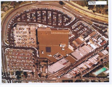
Aerial Photograph, Greensborough Plaza Aerial View, 1979c
Early aerial photograph of Greensborough Plaza, 1970.Colour photocopy of aerial survey, laminatedgreensborough plaza -
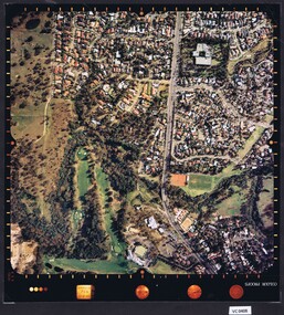
 Heidelberg Golf Club
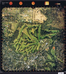
Photograph - Aerial Photograph, Heidelberg Golf Course 2000, 01/05/1980
Aerial photograph of Heidelberg Golf Club course in 1980, showing the course layout and surrounding land use.Aerial photograph, colour.Printed on edge of photo: "Colour proof", "LandSur756"aerial photographs, heidelberg golf club, lower plenty -
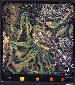
 Heidelberg Golf Club
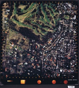
Photograph - Aerial Photograph, Heidelberg Golf Course 2000, 01/05/1980
Aerial photograph of Heidelberg Golf Club course in 1980, showing layout of course and surrounding land use.Aerial photograph, colour.Printed on edge of photo: "Colour proof", "LandSur756"aerial photographs, heidelberg golf club, lower plenty -
 Heidelberg Golf Club
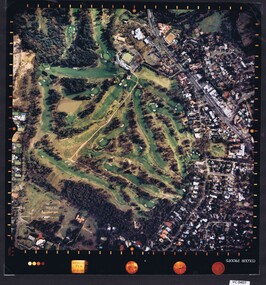
Photograph - Aerial Photograph, Heidelberg Golf Course 2000, 01/05/1980
Aerial photograph of Heidelberg Golf Club course in 1980, showing layout of course and surrounding land use.Aerial photograph, colour.Printed on edge of photo: "Colour proof", "LandSur756"aerial photographs, heidelberg golf club, lower plenty -
 Heidelberg Golf Club
Photograph - Aerial Photograph, Heidelberg Golf Course 2000, 01/05/1980
Aerial photograph of Heidelberg Golf Club course in 1980, showing layout of course and surrounding land use.Aerial photograph, colour.Printed on edge of photo: "Colour proof", "LandSur756"aerial photographs, heidelberg golf club, lower plenty -
 Phillip Island and District Historical Society Inc.
Photograph - Post Card, Early 1900's
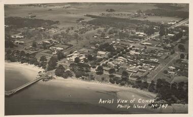
Photograph donated by Les JonesBlack & White postcard of an aerial view of Cowes. Jetty on the left - tree lined Thompson Avenue - Isle of Wight Hotel on the Esplanade left of Thompson Avenue and Bayview Guesthouse on the right on the Esplanade. Township and farmland."Aerial View of Cowes, Phillip Island. No. 147"aerial view of cowes phillip island, cowes township, part cowes township - cowes beach and jetty, phillip island, les jones -
 Vision Australia
Photograph - Image, Aerial view of Elanora Nursing Home, 1980-1989
Aerial view of Elanora Nursing Home. Mair Street and the train line are clearly visible.Aerial photograph mounted on boardassociation for the blind, elanora home (brighton) -
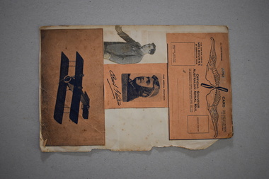 Warrnambool and District Historical Society Inc.
Postcard, Basil Watson Scrapbook, 1917
The Hollywood film stars pasted on to one side of this paper are of no historical interest to our Society. The four paper items attached to the other side relate to the pioneer aviator, Basil Watson. He flew the first aeroplane to come to Warrnambool in January 1917. Watson flew from Point Cook to Warrnambool in one hour 55 minutes, an Australian cross-country flying record at the time. He had built his own aeroplane which was 18 feet long with a wing span of 26 feet and it had a 7 cylinder 50 H.P. rotary Gnome engine. In Warrnambool he amazed the crowds with his dare-devil aerial acrobatics, looping the loop 14 times over the Warrnambool Racecourse. Watson also brought several letters with him, making him the bearer of the first aerial mail to Warrnambool. Sadly Basil Watson died when his plane crashed at Point Cook in March 1917, just two months after his record-breaking flight to Warrnambool. The Warrnambool and District Historical Society has in its collection the small galvanized bucket seat which came from Watson’s plane and the original first air letter written by the Mayor of Melbourne to the Mayor of Warrnambool. These four items are of considerable historical interest as they are souvenirs issued at the time of Basil Watson’s aviation exploits in the early 1900s and Watson is of great importance in the aviation history of Warrnambool.This is a piece of paper (possibly from a scrapbook) with one torn edge. Pasted on to the paper on one side are newspaper photographs of early Hollywood female film stars. On the other side are four items relating to the pioneer aviator, Basil Watson – an airmail post card, a newspaper black and white photograph, a souvenir black and white photograph and a card with an illustration of an early aeroplane (pictured upside down). ‘The Aerial Postman Basil Watson’ ‘Official Souvenir Australian Aerial Mail’ basil watson, pioneer aviator, aviation in warrnambool’s history, history of warrnambool -
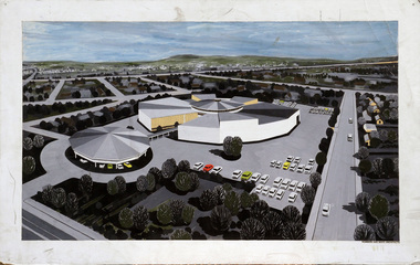 Robin Boyd Foundation
Drawing - Aerial Perspective, Rola Factory, Nunawading
Project: Rola Factory from office of Romberg and Boyd. Aerial PerspectiveAerial Perspective, Poster on Board (Colour) -
 Greensborough Historical Society
Aerial Photograph, St Helena 1945, 1945_
Aerial survey photograph of St. Helena Road area of Greensborough3 copies, various enlargements of aerial surveygreensborough, st helena, st helena road -
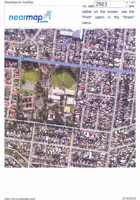 Greensborough Historical Society
Photograph, Nearmap.com, Nearmap: Greensborough, 27/09/2012
Aerial photographs of the Watsonia area, land owned by Black and Families, including sites of Loyola College, Loyola Reserve and Gresswell ReserveFour coloured aerial photographswatsonia, black family, loyola college, gresswell forest reserve -
 Stawell Historical Society Inc
Photograph - 1919 Aerial View Over Stawell, Main Street Area Looking toward Big Hill 1919-- Aerial View
Aerial View – Main Street Area 1919 Looking toward Big HillAerial View over Stawell taken by R J McClure 1919stawell -
 Phillip Island and District Historical Society Inc.
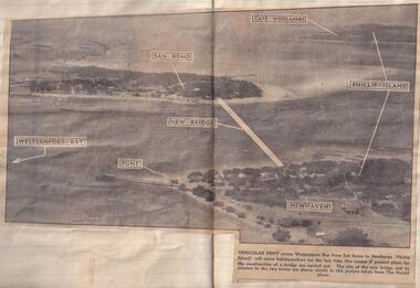
Newspaper clippings
Aerial photograph in newspaperAerial photograph of site of proposed bridge between San Remo and Newhaven.local history, documents, newspapers, bridges, phillip island, black & white newspaper clipping, phillip island. -
 National Wool Museum
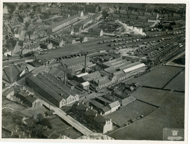
Photograph, Geographia Ltd, Unknown
Aerial photograph of a factory in the UK.Black and white aerial photograph of a factory with townhouses in the background in a landscape format.Front bottom right corner - Geographia Ltd, 167 Fleet Street, London, EC4. Back stamped - Neg. No. 3658 Date Subject Bides (?) 631wool, woollen mills, wool manufacture -
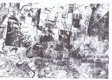
 Greensborough Historical Society
Aerial Photograph, Flintoff land - View from above, 1945_
Section of the 1945 Greensborough aerial survey, focusing on the land belonging to the Flintoff familyPhotocopy of section of 1945 aerial survey of Greensborough area"Flintoff land to west of Diamond Creek Rd" written in pencil on backflintoff family, aerial photograph -
 Greensborough Historical Society
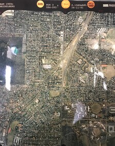
Aerial Photograph, AAM Photographics, Heidelberg AAM1969c 084, 24/11/1991
One of an overlapping series of aerial photographs of the Heidelberg/Greensborough areas, covering Greensborough, Macleod, Viewbank & Yallambie. North boundary Nell Street, South boundary Simpson BarracksLaminated colour aerial photographgreensborough, viewbank, yallambie -
Tatura Irrigation & Wartime Camps Museum
Photograph, 1940
Camp 2 aerial photoBlack and white photograph of Camp 2 (aerial) channel left hand side.camp 2 aerial photo, italian pow camp -
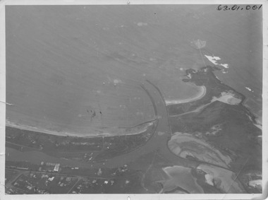 Port Fairy Historical Society Museum and Archives
Photograph, R.W.Golding, 1925
taken in 1925 by W Golding Aerial-Port Fairy Harbour 1925Black and White aerial view of Port Fairy ‘s waterways62.01.001 on front of photograph - on the back-Port Fairy Moyne River Entrance W Goldingaerial view, harbour, griffiths island, w.golding, training walls