Showing 120 items matching "alluvial gold"
-
 Ballarat Heritage Services
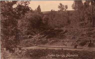
Photograph - Photograph - Black and White, Sutton Spring, Daylesford
... brothers of Cornwell, who discovered it while looking for alluvial... brothers of Cornwell, who discovered it while looking for alluvial ...Emerging from the base of Wombat Creek Sutton Spring has two mineral water pumps. The spring is named after the Sutton brothers of Cornwell, who discovered it while looking for alluvial gold along Wombat Creek in the 1850s. By 1900, a trench had been dug to expose the spring, and a pipe had been driven through the spring eye. Sandstone rockwork encircled the trench. On 27 February 1907 the Sutton Mineral Spring Reserve was gazetted. By that time the trench had been enlarged and rendered, and a lean-to shelter had been built over the approach track. In 1927 Wombat Creek was rerouted allowing the land around the spring to be cleared and pipework repaired. Five bores were dug in 1929 and equipped with hand pumps. The bores were all shallower than 9.7 m. An attempt was made to replace one of these bores with a new bore, however it was not possible due to ground instability. These two bores are the oldest of all the mineral springs open to the public. Also in 1929 Council contemplated encouraging private enterprise to establish a ‘hydrobath’ similar to those in Europe, after mineral water had been discovered flowing from several other vents in sandstone and slate strata below the typical level of the creek. However, the option was not enacted although at the time to capture the flow another bore to a depth of 15m was sunk. In 1936 architect P. Scott Williams adopted a similar notion and examined the prospect of establishing a Hydropathic establishment above Sutton Springs, assuming a reliable mineral water supply could be found. That idea also lapsed. In October 1997 the Sutton Spring trench was restored to enable the public to again take mineral water at the spring. The restoration included clearing the sides of the creek and removing willow root growth. In 2002 a major overhaul of the trench and its underground works was undertaken and all plumbing replaced. This involved re-routing the creek through sandbagging, covering the spring eye with geofabric and then concrete. Unfortunately due to ongoing water quality issues, public access to take water from the trench was closed, however the trench can still be viewed.A mineral water spring at Daylesford is surrounded by a drystone wall. mineral water, sutton spring, daylesford, central springs, p. scott williams -
 Bendigo Historical Society Inc.
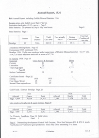
Document - MINING REPORTS - ANNUAL REPORT, INCLUDING GOLD & MINERAL STATISTICS 1936
... issued for 1935 and 1936, Alluvial and quartz gold yields... issued for 1935 and 1936, Alluvial and quartz gold yields ...Handwritten notes from the Annual Report, including Gold & Mineral Statistics, 1936. Mentioned are the London price of gold and the equivalent local price, No of batteries, Abandoned Mining Shafts, Cost of making the shafts safe, Inspection of boilers and the no condemned, No of First and Second Class e 'driver Certificates issued for 1935 and 1936, Alluvial and quartz gold yields for the Bendigo District, men employed in mining, Accidents and development at the Central Nell Gwynne.document, gold, mining reports, annual report including gold & mineral statistics 1936, state batteries, central nell gwynne -
 The Beechworth Burke Museum
Photograph - Photograph - Reproduction, W. D. Gibbon, Early 1900s
... alluvial gold deposits located about 5km south of Beechworth... alluvial gold deposits located about 5km south of Beechworth ...This photograph was taken in 1911 at Three Mile Creek, about five kilometers south of Beechworth town. Significant digging took place at this location from late 1855, which led to a flood of workers and stores to follow, though daily earnings were slim compared to the nearby Woolshed site. This remained the case even after workers at Three Mile Creek attempted to protest around Beechworth during an election in November 1855. Three Mile Creek was one of seven significant divisions of the Beechworth Mining District formalised by the Governor-in-Council in 1858, though by the time this photograph was taken, the boundaries of the original seven districts had shifted to create seventeen divisions. The Three Mile Goldfields was a site of rich alluvial gold deposits located about 5km south of Beechworth in Victoria. Today, the location of this gold deposit is called Baarmutha. It was a popular area for gold mining in the 1850s but became largely abandoned by the following decade. In 1865, a man named John Pund (a man second from the left in the back row of this photograph shares this surname) recognized that the area could be potentially rich if a better water supply could be obtained. He secured a 15 year license with three other miners. Within the next five years, these men had constructed 19 km of water race going from Upper Nine Mile Creek to Three Mile Creek. By 1881, these four men had delivered 950,000 gallons to the Three Mile Sluicing area which is depicted in this photograph. Pund would later go into partnership with John Alston Wallace who would become owner of the Star Hotel in Beechworth. The Three Mile sluicing location continued to be operational until 1950. The eleven miners in this photograph are: Back row: Led Guthrie, P. Pund, F. Beel, [Unknown] Miller Front row: Paddy McNamara, J. King, W. Beel, [Unknown] Garland, J. Clarke, J. Ryan, H. Bartsh In the background of the photograph is a huge dirt wall that appears to suffer damage caused by hydraulic sluicing. Hydraulic sluicing is a specialised mining technique that involves directing high pressure water flows at dirt to uncover gold. The technique played a significant role in shaping Beechworth's landscape during the gold rush to create the topography seen today.The search for gold is ingrained into the history of Victoria and therefore, images like this one which portray an open cut sluicing site can reveal important information for society and technology for the date when the photograph was taken. This image is of important historical significance for its ability to convey information about sluicing and the methods used to find gold in the late 1800s and early 1900s. It also shows a location where sluicing was undertook which provides insight into the impact of sluicing on the environment at a time when it was done. Images, like this one, of Australian gold rush history can reveal important information about the social and environmental impact of this period. This image depicts diggers standing in a mining location and therefore, this image has the capacity to reveal or support significant information for researchers studying the fashion and social status of diggers in Australia in approximately 1911. It can also provide information on the landscape of Australia in this period and the impact of mining for gold on both society and the Australian landscape. The Burke Museum is home to a substantial collection of Australian mining photographs which can be used to gain a deeper understanding into life on the gold fields, technology used in mining, the miners themselves and the impact of the gold digging on the environment.Black and white / sepia rectangular reproduced photograph printed on glossy photographic paper mounted on board.beechworth, beechworth museum, mining, mining team, three mile creek, sluicing, hydraulic sluicing, photography, gold sluicing, gold mining, pund mining -
 Ballarat Heritage Services
Photograph - Photograph - Colour, Clare Gervasoni, Tarilta, 2017, 16/07/2017
... described Tarilta as being an alluvial and quartz gold-mining town... of Guildford and 3 km north-east of Vaughan. The last gold mining ...Tarilta is a rural locality and former gold-mining town 12 km south of Castlemaine, 4 km north-west of Guildford and 3 km north-east of Vaughan. The last gold mining activity took place around the 1880s. It was originally Kangaroo Flat, being located where the Kangaroo Creek enters the Loddon River. It was surveyed and named in 1864. Gold was discovered at Tarilta in 1853. The Tarilta School was opened in 1860 in a Wesleyan chapel, and closed i n1925. In 1864 a township was surveyed and named Tarilta, the word being derived from an Aboriginal expression thought to mean kangaroo. In 1865 Bailliere’s Victorian gazetteer described Tarilta as being an alluvial and quartz gold-mining town with three quartz-crushing mills, three horse-puddling machines and two hotels. The elevated nature of the land around Tarilta made it accessible only by horse and dray, or on horseback. Colour photograph of Tarilta in Central Victoria. tarilta, central victoria, landcape -
 Bendigo Historical Society Inc.
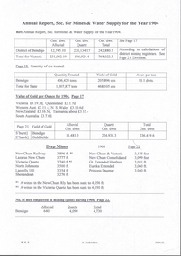
Document - MINING REPORTS - ANNUAL REPORT, SEC. FOR MINES & WATER SUPPLY 1904
... employed in alluvial and quartz mining (gold) during 1904.... employed in alluvial and quartz mining (gold) during 1904. Document ...BHS CollectionHandwritten notes from the Annual Report, Sec. for Mines & Water Supply for the Year 1904. Report mentions gold yield for the District of Bendigo and the Total for Victoria, quantity of ore treated, Value of gold per ounce for 1904 for Australian States, Yield of Gold for Bendigo Goldfield, the deep mines, winze in the New Chum Rly and Victoria Quartz, and the number of men employed in alluvial and quartz mining (gold) during 1904.document, gold, mining reports, annual report sec for mines & water supply 1904, gold yield, value of gold, deep mines, new chum railway, lazarus new chum, victoria quartz, north johnsons, lansells 180, shenandoah, new chum & victoria, new chum consolidated, gt extended hustlers, eureka extended, princess dagmar -
 Eltham District Historical Society Inc
Photograph, Slab hut, Warrandyte, Warrandyte Mystery Tour, 29 May 1994, 29/05/1994
... for prospecting for alluvial gold. Still on this side of the river we... for prospecting for alluvial gold. Still on this side of the river we ...[article by Bettina Woodburn in EDHS Newsletter No. 97, July 1994:] THE WARRANDYTE MYSTERY TOUR MAY 29TH 1994 - Members of the Eltham Historical Society met at the Old Post Office, now converted into the Warrandyte Historical Museum, for a picnic lunch on the sunny back verandah overlooking the shimmering Yarra River. Interesting photographs and artefacts filled various rooms outlining the history of this area, and told tales of Aboriginal and more recent neighbours of the Eltham Shire. The weather was calm, cloudy mostly with only occasional sunny patches, but it wasn't cold, although the autumnal leaf colours had changed to wintry brown. "All Aboard" and we set off in the Warrandyte Community Bus (with the School Bus sign displayed at the rear) to learn about local places of "Pride and Joy” from Bruce our guide and Tom the driver. Almost directly opposite we entered Whipstick Gully to explore the first of the district's hidden treasures - the Victory, one of the largest of the six or so major mines, past the old quarry now used for abseiling practice. By torchlight we entered the rocky hillside and saw the seams of quartz the miners had followed in their search for gold. Stamping batteries, and there was one in this gully, converted discarded rock into 'road metal'. Warrandyte is proud to be the first declared Goldfield in 1851, and one of the longest surviving, into the 1920s. A pleasant drive across the Bridge and along Bradley's Lane to Norman's Reserve brought us to see another Tunnel at Pound Bend through which the Yarra was diverted to allow about three miles of river-bed to be used for prospecting for alluvial gold. Still on this side of the river we visited the Old Slab Hut in Castles Road. This remnant of miners' housing is preserved because it had been incorporated into a weatherboard house, and saved from the bulldozers - a last minute reprieve, for preservation, by the National Trust. Devastating bush fires have destroyed other old cottages built of wattle and daub, with bark roofs and stone fire-places. The Cairn commemorating the disclosure of Gold Discovery at Warrandyte on June 30th 1851 beside Anderson's Creek Road was our next point of historical interest. We drove on to South Warrandyte and circled back to above the ford on Anderson's Creek to the entrance of the 4th Hill Mine. Again we crept along with our torches, careful of the low roof-rock, and side shafts. At a junction in a large cavity we were able to stand, look up a long air-vent which some 'cavers' climb down, and marvel at, and experience an aspect of a miner's life. Outside we heard the same bird songs, the trills and bell-pealing, saw the same straggly eucalypts, and a silver leafed wattle in flower, native grasses and ferns, and the neat present day houses, often of Warrandyte stone, perhaps veneered only. The day ended pleasantly, seeing more of the Yarra from Everard Drive, and the water rushing out of the Tunnel at Pound Bend, before returning to afternoon tea or coffee at the Museum. A great day for all concerned - many thanks to the Organisers.Colour photographslab hut, warrandyte, "warrandyte miner's cottage" -
 Eltham District Historical Society Inc
Photograph, Pound Bend tunnel, Warrandyte, Warrandyte Mystery Tour, 29 May 1994, 29/05/1994
... for prospecting for alluvial gold. Still on this side of the river we... for prospecting for alluvial gold. Still on this side of the river we ...[article by Bettina Woodburn in EDHS Newsletter No. 97, July 1994:] THE WARRANDYTE MYSTERY TOUR MAY 29TH 1994 - Members of the Eltham Historical Society met at the Old Post Office, now converted into the Warrandyte Historical Museum, for a picnic lunch on the sunny back verandah overlooking the shimmering Yarra River. Interesting photographs and artefacts filled various rooms outlining the history of this area, and told tales of Aboriginal and more recent neighbours of the Eltham Shire. The weather was calm, cloudy mostly with only occasional sunny patches, but it wasn't cold, although the autumnal leaf colours had changed to wintry brown. "All Aboard" and we set off in the Warrandyte Community Bus (with the School Bus sign displayed at the rear) to learn about local places of "Pride and Joy” from Bruce our guide and Tom the driver. Almost directly opposite we entered Whipstick Gully to explore the first of the district's hidden treasures - the Victory, one of the largest of the six or so major mines, past the old quarry now used for abseiling practice. By torchlight we entered the rocky hillside and saw the seams of quartz the miners had followed in their search for gold. Stamping batteries, and there was one in this gully, converted discarded rock into 'road metal'. Warrandyte is proud to be the first declared Goldfield in 1851, and one of the longest surviving, into the 1920s. A pleasant drive across the Bridge and along Bradley's Lane to Norman's Reserve brought us to see another Tunnel at Pound Bend through which the Yarra was diverted to allow about three miles of river-bed to be used for prospecting for alluvial gold. Still on this side of the river we visited the Old Slab Hut in Castles Road. This remnant of miners' housing is preserved because it had been incorporated into a weatherboard house, and saved from the bulldozers - a last minute reprieve, for preservation, by the National Trust. Devastating bush fires have destroyed other old cottages built of wattle and daub, with bark roofs and stone fire-places. The Cairn commemorating the disclosure of Gold Discovery at Warrandyte on June 30th 1851 beside Anderson's Creek Road was our next point of historical interest. We drove on to South Warrandyte and circled back to above the ford on Anderson's Creek to the entrance of the 4th Hill Mine. Again we crept along with our torches, careful of the low roof-rock, and side shafts. At a junction in a large cavity we were able to stand, look up a long air-vent which some 'cavers' climb down, and marvel at, and experience an aspect of a miner's life. Outside we heard the same bird songs, the trills and bell-pealing, saw the same straggly eucalypts, and a silver leafed wattle in flower, native grasses and ferns, and the neat present day houses, often of Warrandyte stone, perhaps veneered only. The day ended pleasantly, seeing more of the Yarra from Everard Drive, and the water rushing out of the Tunnel at Pound Bend, before returning to afternoon tea or coffee at the Museum. A great day for all concerned - many thanks to the Organisers.Two colour photographswarrandyte, activities, pound bend -
 Federation University Historical Collection
Book - Register, Berry Anderson & Co, Ballarat School of Mines Gold Entry Book. 1908-1976, 01/06/1908-01/12/1976
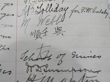
... , District, Where Obtained, Character of Gold (eg alluvial, smelted..., District, Where Obtained, Character of Gold (eg alluvial, smelted ...The Ballarat School of Mines had a model mine used by students, and to conduct assays for a fee. The Register of Gold Entry Book had to be kept by the Licensed Gold Buyer or Assayer under the Gold Buyers Act.Brown half leather bound register registering receipt of gold. Columns include date, nature of transaction (eg assaying/purchase), age, where employed, business (eg mining, fossicking, assayer, etc), Abode, Signature, Witness, Claim, Mining Division, District, Where Obtained, Character of Gold (eg alluvial, smelted, quartz, etc), Weight, Value, How Gold Treated, To whom delivered after assay or smelting, Date of Assayer's Certificate. ballarat school of mines, model mine, battery, assay, smelting, gold, robinson, frederick martell, r. callister, a. garrard, peter tong, lee sue, ah lung, chinese, f.w. calaby, ah kit, charlie ah lung, ah sung, ah chee, dep choon, charlie ah hing, frederick greaves, peter fong, george ah ki, ah hing, william mong, thomas bell and party, brown hill, dentist, amalgam, albert sydney sergeant, plumber, plumbing, george spence, plumber, commonwealth bank, j. hutton-jones, golden duke mining syndicate, blackwood, d.e.j. grant, eganstown, linton gold mining company, mining, d. bernard, g. peron, john page, david bernard, harry webb, ah fou, w.d. thompson, a.b. tolliday, m. webb -
 Orbost & District Historical Society
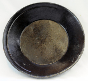
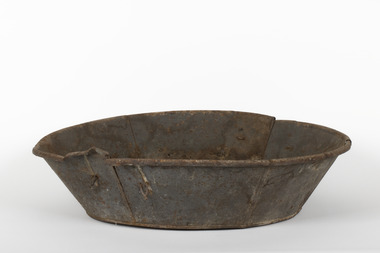
gold panning dish, mid - late 19th century
... Panning dishes were used for washing fine gold from river... gold. Gold pans had widespread use in alluvial gold fields ...Panning dishes were used for washing fine gold from river sediments or from the residue trapped in cradles and puddling tubs. They were often used on the edge of streams/rivers to sift gold from alluvial soil or crushed quartz. This simple pan would have been filled with sand and gravel which might have contained gold. The pan was submerged in the water and shaken to sort the gold from the gravel and other material, with the lighter material gradually being washed over the lip until only the heavy deposits, such as gold, remained at the bottom. (ref. Museum Victoria) This pan was used by George Henry Douglas Russell Snr. As a young man prior to his enlistment in WW1 he panned for gold using this dish. During the war he became a vet sergeant in charge of horse lines.Gold panning is the oldest and simplest method of extracting gold. Gold pans had widespread use in alluvial gold fields where water is available. This item is an example of the type of pan commonly used on Victorian gold fields.A circular dull metal panning dish which has a wide rolled top lip which tapers down to a smaller diameter for the base which is flat. The pan has been made from ironmetal which has a coating of another metal with a matte grey finish. It has a small hanging hole and a reinforcing ring all around the top.russell-doug gold-panning mining -
 Eltham District Historical Society Inc
Photograph - Digital Photograph, Alan King, Golden King Mine poppet-head, Yarrambat Primary School, 1 February 2008
... . At first there was plenty of alluvial gold, as much as two ounces.... At first there was plenty of alluvial gold, as much as two ounces ...The Golden King Mine poppet-head stands at the school’s Yan Yean Road exit gate. Published: Nillumbik Now and Then / Marguerite Marshall 2008; photographs Alan King with Marguerite Marshall.; p23 Early Yarambat - Tanck's Corner Its early settlers, who in the 1840s were amongst the first non-Aboriginal people in the area, found life tough as they grazed their sheep and cattle. Yarrambat was then known as Tanck’s Corner or Reynolds Corner, after wood carter, Frederick Tanck, who owned land north of Ironbark Road, at the corner of Yan Yean Road, and Thomas Reynolds, owner of the opposite property. After Reynolds sold his land, the corner became known as Tanck’s Corner. In 1929 the district’s name was changed to Yarrambat, believed to mean ‘high hill’ in the Wurundjeri language. Tanck’s Corner was in the centre of gold-bearing country and the district is honeycombed with old tunnels and shafts. However although gold played a dominant role for decades, there was insufficient to develop a substantial township. Meat and agricultural produce made a greater impact. Until the mid-20th century the only substantial building was the primary school. The first gold rush occurred around 1860, the second after 1900; then during the Depression, the Government paid men to pan for gold. The first rush attracted hundreds of Chinese people to Smugglers Gully, who constructed round diggings to keep away spirits. Alluvial miners lived along the Plenty River in tents or humpies - some fenced with gardens - and some miners distilled their own ‘plonk’. It was a wild time and bushrangers - and later gangster Squizzy Taylor - were said to hide4 in the old Pioneer Tunnel in Dunne’s Gully between Heard Avenue and Pioneer Road. Mines opposite Tanck’s Corner included Beer’s Line, Golden Crown and Golden Stairs. Some of the big mines had batteries and stampers to process quartz. At first there was plenty of alluvial gold, as much as two ounces to the ton. At times gold was exposed after heavy rains so fossickers panned for gold around orchard irrigation trenches. Gold was mined until 1984 when Yarrambat’s last operating goldmine, the Golden King Mine, in North Oatlands Road, closed. The Clayton family operated it full-time, making a comfortable living and in the 1960s it was the only private family gold mine in Victoria.5 Gold was such an important part of Yarrambat’s history that a gold poppet-head is the Yarrambat Primary School’s logo. The Golden King Mine poppet-head stands at the school’s Yan Yean Road exit gate. However this school was built in 1988. The original school No 2054, at the corner of Ironbark and Yan Yean Roads, was opened in 1878 and modified to its present form in the 1920s. In 2000 it was relocated to the Heritage Museum at Yarrambat Park.7 The school, whose first head teacher was Charles Planner, consisted of one room with a three-roomed residence. The school was also the community centre. On Saturday nights it was crammed for dances or euchre parties, community singing or other social events. On Sundays, services for different denominations took turns each week. However the school had its teething problems. Parents accused Charles Planner of neglecting his duties and the school closed several times. When it closed in 1892, only church services continued. Social activities moved elsewhere, such as the tennis club to the Stuchbery tennis court opposite. A sports day and woodchop on Boxing Day around 1900 was held at the Evelyn Hill Hotel, also called Evelyn Arms and Tunnel Hill Hotel, on the Greensborough–Diamond Creek Road. An annual agricultural show in Diamond Creek paraded through the town, and New Year’s Day picnics at the Yan Yean Reservoir included highland dancing and competitions. Also popular were the Indian hawkers who visited every three months, selling trinkets, clothing and other items. One called Jimmy ‘Allem dem Bedi’, gave presents and told stories, played draughts and sold delicious curries he cooked over his camp fire at night.This collection of almost 130 photos about places and people within the Shire of Nillumbik, an urban and rural municipality in Melbourne's north, contributes to an understanding of the history of the Shire. Published in 2008 immediately prior to the Black Saturday bushfires of February 7, 2009, it documents sites that were impacted, and in some cases destroyed by the fires. It includes photographs taken especially for the publication, creating a unique time capsule representing the Shire in the early 21st century. It remains the most recent comprehenesive publication devoted to the Shire's history connecting local residents to the past. nillumbik now and then (marshall-king) collection, golden king mine, tanck's corner, yarrambat primary school -
 Eltham District Historical Society Inc
Photograph - Digital Photograph, Alan King, Panton Hill Hotel, 27 March 2008
... of £100,000, and fossikers also found alluvial gold in the creeks... of £100,000, and fossikers also found alluvial gold in the creeks ...Today’s Panton Hill Hotel was built around 1920. Published: Nillumbik Now and Then / Marguerite Marshall 2008; photographs Alan King with Marguerite Marshall.; p61 Panton Hill was originally known as Kingstown, and consisted of only one hotel when the Orams Reef was discovered in 1859. Kingstown was a quartz mining centre and many old mine shafts remain in the area. Orams Reef was one of the first reefs with a rich find of gold in the area. The Hotel Francais, which had been operating in 1861, was well situated on the way to Queenstown (later St Andrews). So was Herr Hirt’s Hotel and store at Smiths Gully. The Kingstown hotel, known as the Frenchman’s and in 1864 as the Hotel de France, was run by a Monsieur Emile Hude and his wife Jeanne, and known for its good food. They hosted social events, business conventions and debates, attracting patrons from as far as Melbourne. The hotel’s name was changed to Panton Hill Hotel in 1905. In 1883 Charles Caudwell built another hotel nearby, possibly in Long Gully Road,3 which it is thought, was burnt down early last century. Today’s Panton Hill Hotel, built around 1920, is the only one of the cluster of buildings in the main road, not to date from around the turn of last century. It was severely damaged by fire in 2003, then underwent extensive alterations. It is the township’s only hotel and is an example of a modest hotel building exterior, constructed early last century. In its early days the hotel also housed the first post office, newsagency and store. Orams Reef yielded a total of £100,000, and fossikers also found alluvial gold in the creeks and gullies, but there is no record of the total value of their finds. Gold greatly increased the Panton Hill population, which peaked between 1865 and 1885. On holidays large sports meetings were held with wood chopping contests and foot races and the day would end with a ball. Miners came from various countries to seek their fortune, including many from China. The Chinese became unpopular however, and gradually left the district, although some stayed and grew and sold vegetables.5 Panton Hill was named after Joseph Panton, who in 1862 was appointed Police Magistrate for the Woods Point, Heidelberg and Yarra districts. Panton was an outstanding man, who in 1852, was Commissioner of Crown Lands and Assistant Commissioner of Goldfields at Bendigo. In 1874 he was promoted to Chief Magistrate for the Melbourne Police. Panton was also an artist, becoming president of the Victorian Arts Society in 1888, and in 1913, president of the Royal Geographical Society. Despite Panton Hill’s prosperity, it still lacked many services as poor roads made access to Melbourne difficult. A horse-drawn mail coach travelled to Melbourne until 1890, when the railway came to Heidelberg. The nearest doctor was at Yarra Glen or Heidelberg, and the Indian hawker Singh’s annual visit was very welcome. A miner’s shack opposite the school was used as a post office. Today’s general store and post office in the main road dates from early last century, and has changed considerably. While most people searched for gold, the more enterprising ones established farms to feed the diggers. Farmers grew wheat, barley and oats, and sent animal skins to the Eltham tannery, to make furs in Melbourne. As gold became scarce from around 1880, miners took up farming on 19 to 20 acre (8ha) allotments. The first settlers in Cherry Tree Road included Purcell, Smith, Owens, Hughes and Shillinglaw. By 1900 all the land had been taken up around Panton Hill and Hurstbridge. The orchards in Panton Hill and the wider district, particularly of apple and pear, were very successful, and made Panton Hill a cohesive and successful community. About 1914 the Moores built the first cool-store and refrigeration plant at their orchard in Cherry Tree Road. Many settlers planted vineyards and made high quality wine, but in 1922 the blight destroyed them.This collection of almost 130 photos about places and people within the Shire of Nillumbik, an urban and rural municipality in Melbourne's north, contributes to an understanding of the history of the Shire. Published in 2008 immediately prior to the Black Saturday bushfires of February 7, 2009, it documents sites that were impacted, and in some cases destroyed by the fires. It includes photographs taken especially for the publication, creating a unique time capsule representing the Shire in the early 21st century. It remains the most recent comprehenesive publication devoted to the Shire's history connecting local residents to the past. nillumbik now and then (marshall-king) collection, panton hill hotel -
 Eltham District Historical Society Inc
Photograph - Digital Photograph, Marguerite Marshall, One Tree Hill Mine, Smiths Gully, 8 June 2006
... of their fortune worked the alluvial gold in the Yarra River, its... of their fortune worked the alluvial gold in the Yarra River, its ...Gold was discovered on One Tree Hill in 1854. The site has been worked intermittently until fairly recent times. Published: Nillumbik Now and Then / Marguerite Marshall 2008; photographs Alan King with Marguerite Marshall.; p53 Though still a working mine, One Tree Hill Mine at Smiths Gully, now stands in a tranquil reserve surrounded by bush and native animals - in contrast to its heyday. In the mid 19th century, when the mine was part of the Caledonia Goldfields, hundreds of men in search of their fortune worked the alluvial gold in the Yarra River, its tributaries and the reefs that made up the goldfields. Miner Stan Bone, assisted by Wilfred Haywood, is the last of the independent gold miners in the area and still uses the quartz crushing battery as miners did when gold was first discovered in the area in 1851.1 Stan, who is the last of six generations of miners in his family, was aged 17 when he began mining on his father Alex’ mine, The Golden Crown in Yarrambat. These days, after blasting the gold-bearing rock in Mystery Reef, one of the four reefs at One Tree Hill, Stan transports it around five kilometres by tip truck to the Black Cameron Mine for crushing. There he uses water from the waterlogged mine, (which still contains gold), as the Happy Valley Creek at One Tree Hill is usually dry.2 The One Tree Hill Mine has been worked for close to a century since it opened around the late 1850s.3 The Swedish Reef was its most productive reef and one of the largest in the area. Around 1859, extractions included 204 ounces (5.8kg) of gold, won from 57 pounds (26kg) of stone.4 Then during World War Two, Stan’s uncle, Bill Wallace, and Alex Bone, closed the mine. In 1973, Stan, with his Uncle Bill, reopened the Black Cameron Mine and worked there until 1988. Stan resumed mining One Tree Hill in 1998. As late as the 1920s gold was picked up by chance! When crossing a gully on his way to vote at the St Andrews Primary School, Bill Joyce picked up some quartz containing gold. This site was to become the Black Cameron Mine. The Caledonia Diggings, named after Scotland’s ancient name by local Scots, began around Market Square (now Smiths Gully) and included Queenstown (St Andrews), Kingstown (Panton Hill) and Diamond Creek. There were also poorer bearing fields in Kangaroo Ground and Swipers Gully (now Research). * None of these compared in riches to the Ballarat and Bendigo fields5, but the Caledonia Diggings continued intermittently for close to 100 years. Gold was discovered in Victoria following a bid to stem the disappearance of much needed workmen to the New South Wales diggings. Several businessmen offered a reward of £200, for the discovery of gold within 200 miles (322 km) of Melbourne. Late in June 1851, gold was first discovered at Andersons Creek, Warrandyte. Then in 1854, George Boston and two other men discovered gold at Smiths Gully. Gold transformed the quiet districts, with a constant flow of families and vehicles on the dirt tracks en route to the Caledonia Diggings. Three thousand people worked the gullies in Market Square, including about 1000 Chinese miners. The square established its own police, mining warden, gold battery, school, shops and cemetery and grog flowed. Market Square flourished until the middle 1860s. Bullocks transported quartz from the Caledonia Goldfields to the crushing machinery at the Queenstown/St Andrews Battery, near Smiths Gully Cemetery. It was destroyed by bushfire in 1962. By the late 1850s, most early alluvial fields were in decline, but minor rushes continued until around 1900 and some until the early 1940s. Some miners did well, although most earned little from their hard labour in the harsh and primitive conditions.6 But according to historian, Mick Woiwod, the gold fields helped to democratise society, as individuals from all walks of life were forced to share experiences, and the ability to succeed, depended less on inherited wealth or social rank.This collection of almost 130 photos about places and people within the Shire of Nillumbik, an urban and rural municipality in Melbourne's north, contributes to an understanding of the history of the Shire. Published in 2008 immediately prior to the Black Saturday bushfires of February 7, 2009, it documents sites that were impacted, and in some cases destroyed by the fires. It includes photographs taken especially for the publication, creating a unique time capsule representing the Shire in the early 21st century. It remains the most recent comprehenesive publication devoted to the Shire's history connecting local residents to the past. nillumbik now and then (marshall-king) collection, gold mining, one tree hill mine, smiths gully -
 Bendigo Historical Society Inc.
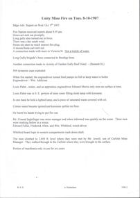
Document - ULSTER GOLD MINING COMPANY NO LIABILITY - UNITY MINE FIRE 8/10/1907 & FAMOUS GOLD MINES
... and Eaglehawk. Notes give yields of gold for alluvial and quartz mining... and Eaglehawk. Notes give yields of gold for alluvial and quartz mining ...Typed copy of recount by Albert Richardson of a fire at Unity Mine on Tuesday 8-10-1907. Report from the Bendigo Advertiser Wednesday October 9th 1907. Notes mention Fire Brigade, miners, how the fire started and how the men down the shaft escaped when the rope crash down the shaft. On the back is a handwritten carbon copy of notes titled Famous Gold Mines of Bendigo and Eaglehawk. Notes give yields of gold for alluvial and quartz mining. Deep Shafts in 1904 of which there were eleven with a depth of more than 3000 feet and 53 over 2000 feet and two which were more than 4000 feet. Wages for 1911 for Engine Drivers and Firemen and Boiler Attendants. Note on winding plants and air compressors.document, gold, ulster gold mining coy no liability, ulster gold mining company no liability, unity mine fire 8/10/1907, bendigo advertiser 9/10/1907, garden gully reef hotel, wm addicoat, louis pabst, edward morris, conrad inglefinger, edward fuller, frederick allen, wm whitford, mr jewell, carlisle mine, famous gold mines of bendigo and eaglehawk, new chum line, garden gully line, hustlers line, victoria quartz mine, new chum railway, mines report 1911 p15, albert richardson -
 The Beechworth Burke Museum
Photograph
... down the soil which was then processed for quartz, gold... down the soil which was then processed for quartz, gold ...This photograph dating between the 1850s and early 1900s depicts an open cut sluicing site located in Allan's Flat looking upon the open cut from Staghorn Flat Number 1. Sluicing was undertaken in the area from 1850 to 1904. The image depicts a location mined by Yackandandah Sluicing Co. It portrays and open space with pipes laying on the ground and connected to pipes leaving the barge. These pipes were used to wash and seperate the qaurtz. There are two small buildings on high ground over looking the barge. Yackandandah Sluicing Co. was created by J.A. Wallace in the 1880s. The Yackandandah Sluicing Co. operated from the mid-1880s to the early 1900s, when resources eventually ran out. Open cut sluicing involved the use of high-powered hoses which used the centrifugal sand pump system (known as hydraulic sluicing) which broke down the soil which was then processed for quartz, gold and other materials. After the resources where drained, Wallace reaped the benefits of his mining business. Allan's Flat is located on the Yackandandah Creek, and is 10km north-east of Yackandandah and 20km south of Wodonga in Victoria's regional north-east. Allan's Flat was initially used to mine gold through alluvial methods, however that came to an end with little results. The mining business was then revived by J.A. Wallace with the introduction of hydraulic sluicing.The search for gold is ingrained into the history of Victoria and therefore, images like this one which portray an open cut sluicing site can reveal important information for society and technology for the date when the photograph was taken. This image is of important historical significance for its ability to convey information about sluicing and the methods used to find gold and other minerals in the lat 19th Century. It also shows a location where sluicing was undertook which provides insight into the impact of sluicing on the environment at a time when it was done. This image is important for current research into the history of Allan's Flat, a small regional location near Yackandandah in Victoria's North East. Therefore, this image has the capacity to be beneficial for research into society and the motivations of those living and working in this region during this period and therefore, has social significance. The Beechworth Burke Museum has additional images relating to gold sluicing and Allan's Flat which can be analysed and studied alongside images like this one.Sepia coloured retangular photograph printed on gloss photographic paper mounted on board.Revers: Sluicing at Allan's Fortallan's flat, north east gold, sluicing, gold sluicing, hydraulic sluicing, mining, gold and quartz mine, beechworth, burke museum, yackandandah -
 Bendigo Historical Society Inc.
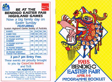
Document - BENDIGO EASTER FAIR 1985, 5 April 1985
... in mid 1850's in teams or groups to work the rich alluvial gold... in mid 1850's in teams or groups to work the rich alluvial gold ...Bendigo Easter Fair 1985, April 5-8. Programme Booklet. Friday: Sun Loon Display, Easter Bowling Carnival, Rotary Easter Art Show, Book Bazaar, Model Railroaders Exhibition, Dudley House, Exhibition of Dolls, Embroiderers Guild, Art Gallery. Saturday: Mardi-Gras Street Carnival, Busking, Outdoor Theatre, Arts & Music, Bendigo Theatre Company, Cynthia Holland & Bendigo Talent Club Sun Loong Display, Rotary Art Show, Handcraft Bazaar, Motorcycle Show-Sandhurst Historic Vehicle Club Trams, Central Deborah, Dudley House, Exhibition Dolls, Antique Fair, Model Railroaders, Fire Brigades' Carnival for Children, Horse & Harness Parade, Book Bazaar, Bowling Carnival, Football, Photographic Exhibition, Family Activities, Cinema 180, Exhibition of Paintings silver furniture & porcelain, Embroiders Guild. Sunday: Horse Spectacular, Model Railroaders, Rotary Art Show, Handcraft Bazaar, Antique & Historical Display of Arms Weapons & Military, Antique Fair, Torchlight Procession, Awakening of Dragon, Exhibition of Dolls, Dudley House, Trams, Central Deborah, Book Bazaar, Mardi-Gras Street Carnival, Hargreaves Mall, Motorcycle Show, Photographic Exhibition, Family Activities, Cinema 180, Art Gallery, Embroiderers Guild. Monday: Philatelic Society Exhibition, Rotary Art Show, Handcraft Bazaar, Antique Fair, Model Railroaders, Bendigo District Bowling Assn. Easter Bowling Carnival, Exhibition of Dolls, Dudley House Bendigo Branch Royal Historical Society, Trams, Central Deborah, Motorcycle Show, Antique and Historical Display of Arms Weapons & Militaria, Mardi-Gras Street Carnival, Hargreaves Mall, Gala Street Procession, Carnival For Children, Sun Loong on Display, Photographic Exhibition, Fusion, Cinema 180, Art Gallery, Embroiders Guild. Church Services in Bendigo City Area During Easter (listings for Thursday, Good Friday, Eater Saturday, Easter Day). The Bendigo & District Tourism Association Welcomes you to Victoria's Premier Town. Listing of events over Easter with map to guide all around. Bendigo Easter Fair Incorporated Phone: (054) 43 9191Bendigo Easter Fair Inc. would like to thank the Ministry for the Arts for its continued assistance over the past 11 years. 3 1/2 pages of information on the Bendigo Easter Fair and its rich history dating back to 1871. The first Fair was held to aid 2 charities: Bendigo Base Hospital and the Home and Hospital for the Aged (Benevolent Asylum). Gone are the days of the Fancy Bazaar, Fat Baby Contest and the greasy Pig Chase, many tradition remain the same. Links to the Chinese community date back to when the first settlers arrived seeking gold. This gives the Fair its unique quality and Brings visitors in their thousands each Easter. The Monday Procession has always been the most famous as many old photographs show. Some photos taken before the turn of the century. Many made the journey to Bendigo from Melbourne and outlying districts. Visitors line the route to see floats, bands, and the once a year appearance of the Chinese Dragon, ''Sun Loong'' or ''New Dragon''. The longest Imperial Dragon in the World; 300ft plus in length. His predecessor, ''Long'', is acclaimed as the worlds oldest Imperial Dragon. Easter Saturday Procession has taken form of a Horse and Harness Parade, attracting and immense variety of entrants. The torchlight Procession on Sunday evening includes fireworks, Fire Brigades, Fire Trucks, firemen, marching girls and illuminated floats. The Army has helped with the procession since around the time of Federation. 15th Transport Squadron (15 Tpt. Sqdn.), processions are assembled & dispatched with Army efficiency. Marshalling the Monday Procession this year will be done by the Army as well as our own Easter Fair marshalls with a new communications system.1930 the Popular Girl contest was introduced. The four main streets of Bendigo, Pall Mall, Mitchell Street, Hargreaves Street and Williamson Street (formerly View Street), sponsored their particular girl by means of raffles, street stalls and a variety of fund raising. The winner was the one that raised the most money, and was announced from the balcony of the Shamrock Hotel, by the Mayor of Bendigo on Easter Saturday Night. The Popular girl contest is still held with a lot of the fund raising now done by service clubs and voluntary organizations. 1984 fund raising efforts, in excess of $50,000 was distributed to charities in our area. The combined Bendigo Brigades' record support for the Easter Fair goes back of many years in a variety of ways. Bendigo people are known for their love of sport and the choice in the city is very wide. There will be no Easter Sports Carnival this year but Easter Fair will still be holding functions at the Bendigo Sports Centre in Park Road. Bendigo city centre will be alive with stalls, raffles and rides of every description over the three days of sports, Sat-Sun. Hargreaves Mall will be the focus of relaxation, buskers, community theatre, arts with craft activity & musical entertainment. The Rotary Club of Bendigo and the Easter Fair Society had had independent Arts Shows but in 1981amalgamate their shows. 1981 Rotary Club of Bendigo added the Antique Fair to the Easter Program, held in the RSL Memorial Hall, Pall Mall. Last year some event were cancelled, but last year's Fair was quite a success. With many outdoor activities, the weather plays a vital role. It has been necessary to alter some venues in the past years, with Easter being a week early in April this year we are looking forward to fine conditions. The Chinese and Bendigo Easter Fair, The First Chinese arrived on the goldfields in mid 1850's in teams or groups to work the rich alluvial gold fields of Dai Gum San (Big Gold Mountain). Most were of poorer class from the district of See Yup, an area of four villages near the provincial capital Canton (Kwangchow). By far the largest group came from the village of Toi Shan. The alluvial gold quickly petered out so by the time of the first Bendigo Easter Fair in 1871 most Chinese had either left for richer fields or turned to other pursuits such as stores, market gardens, laundries, herbalists etc.. Many of course had died on the fields from the rigors of mining of diseases not encountered in their homeland. The Benevolent Asylum (Home & Hospital for the age) and Bendigo Base Hospital had become places of rest, help and haven for old, sick and lonely Chinese. SO when the idea was mooted to hold a charity fair to raise money for these worthy establishments, the Chinese were only too happy to join with the Easter Fair Society in this charitable work. It has for over 113 years. Chinese showed their costumes, scenery, and weapons of warfare, but it was not until 1892, that the first of the 5 loongs (dragons) appeared.. . The pageant was marshalled by Mr T Chapman and headed by Mr Moody, attired in habiliments of a most gorgeous character on a gaily caparisoned horse, and his get up as a Chinese grandee was perfect. . . Tom toms , bagpipes. . Wind instrument resembling a clarinet. . Bagpipes,.. The Weekly Advertiser, Friday, April 22,1892. . . Today the Chinese Association, made up of descendants and families of the early Chinese and associate members, carries on the charitable works of their predecessors. A Little Of Dragons, We have all heard of St. George Bendigo dragons (loongs) have none of these characteristics, in fact they have only brought good to Bendigo. There are 3 chief species of Chinese Dragons of which ''The Lung'' (Loong) is the most powerful. It is also the spiritual dragon which produces wind and rain. It has 9 resemblances, the head of a camel, horns of a deer, eyes of a rabbit ears of a cow, neck of a snake, belly of a frog, scales of a carp, claws of a hawk and palm of a tiger. Loong is a vegetarian, favourite food pomelo (ooluk), the father of our modern grapefruit. The abode, according to legend is the sky or water. He is also deaf, thus requiring loud noises to awaken him and to keep him awake. . . Number of claws they have represent rank. Dragons have 2, 3, 4 or 5 claws, the latter being reserved for the Emperor. Loong and Sun Loong have both five claw dragons. Bendigo has had 5 or 6 dragons, the number being confused by the fact each dragon was called 'Loong'. Today Three dragons remain in Bendigo, Loong, Sun Loong, and Yar Loong. Loong is the oldest Imperial Dragon in the world. He continued his walk through the streets of Bendigo til his retirement in 1970. He was created in Fat Shan in the Peoples Republic of China. Built of. . . Sun Loong replaced Loong after the 2 dragon procession of 1970. Created by Mr Law On, . . Yar Loong is a night dragon, came in 1930's. . . Long history of dragons. . The Birth Of A Dragon. . . To awaken A Dragon. . . The Easter Monday Chinese Procession. . . Procession divided into 6 sections,.. The Easter Monday Procession comprises,… over 350 people. Conclusion It is hoped that in the near future a museum can be built to house the priceless regalia gathered together over the last century and a half by the Bendigo Chinese Association. Advertisements; Historic Bendigo Pottery, Mim's Restaurant, Antique Fair (Rotary), The Copper Pot, Sandhurst Town (Develop Victoria Council Tourism Award 1983-1985), Bendigo Motor Co. (Mazda), Diggers, Chaplin's, Bendigo's Dunny Diner, Arakoon, Quin's Bluebird, Allara Motor Lodge, Lakeview Motor Inn, The Armoured Car Company, Gillies, Mardi Gras Street Carnival, Handcraft Bazaar, Art Show (Rotary) Bendigo Model Railroaders (Easter Exhibition), Bendigo Easter Fair Highland Games brought to you by TV8 and Coca-Cola Bottlers. Design and Finished Art By Graphics Group, Bendigo.Graphics Group Bendigoevent, easter fair, bendigo easter fair incorporated, bendigo easter fair 1985, april 5-8. programme. friday: sun loon display, easter bowling carnival, rotary easter art show, book bazaar, model railroaders exhibition, dudley house, exhibition of dolls, embroiderers guild, art gallery. saturday: mardi-gras street carnival, busking, outdoor theatre, arts & music, bendigo theatre company, cynthia holland & bendigo talent club sun loong display, rotary art show, handcraft bazaar, motorcycle show-sandhurst historic vehicle club trams, central deborah, dudley house, exhibition dolls, antique fair, model railroaders, fire brigades' carnival for children, horse & harness parade, book bazaar, bowling carnival, football, photographic exhibition, family activities, cinema 180, exhibition of paintings silver furniture & porcelain, embroiders guild. sunday: horse spectacular, model railroaders, rotary art show, handcraft bazaar, antique & historical display of arms weapons & military, antique fair, torchlight procession, awakening of dragon, exhibition of dolls, dudley house, trams, central deborah, book bazaar, mardi-gras street carnival, hargreaves mall, motorcycle show, photographic exhibition, family activities, cinema 180, art gallery, embroiderers guild. monday: philatelic society exhibition, rotary art show, handcraft bazaar, antique fair, model railroaders, bendigo district bowling assn. easter bowling carnival, exhibition of dolls, dudley house bendigo branch royal historical society, trams, central deborah, motorcycle show, antique and historical display of arms weapons & militaria, mardi-gras street carnival, hargreaves mall, gala street procession, carnival for children, sun loong on display, photographic exhibition, fusion, cinema 180, art gallery, embroiders guild. church services bendigo city easter , eater saturday bendigo & district tourism association victoria's premier town. bendigo easter fair incorporated bendigo easter fair rich history 1871. base hospital and the home and hospital for the aged (benevolent asylum). fancy bazaar, fat baby contest greasy pig chase, many old photographs floats, bands, chinese dragon, ''sun loong'' or ''new dragon''. the longest imperial dragon in the world; 300ft plus in length easter saturday procession horse harness parade. torchlight procession on sunday evening includes fireworks, fire brigades, fire trucks, firemen, marching girls and illuminated floats. army helped federation. 15th transport squadron (15 tpt. sqdn). monday procession by the army 1930 popular girl contest introduced. four main streets, pall mall, mitchell street, hargreaves street williamson street. winner announced shamrock hotel, easter saturday night. popular girl contest fund raising service clubs voluntary organizations. 1984 fund raising efforts, in excess $50, 000 distributed to charities. combined bendigo brigades'. no easter sports carnival holding functions bendigo sports centre in park road. stalls, raffles three days sports, sat-sun. relaxation, buskers, community theatre, arts with craft activity & musical rotary club of bendigo easter fair society independent arts shows in 1981amalgamate antique fair, held last year some event cancelled. with many outdoor activities, weather plays vital role. alter some venues in the past, easter being a week early first chinese arrived goldfields in mid 1850's dai gum san (big gold mountain). see yup, canton (kwangchow). toi shan. first easter fair in 1871 for richer fields other pursuits stores, market gardens, laundries, herbalists etc. benevolent asylum (home & hospital for the age) bendigo base hospital had become places of rest, help and haven for old, chinese. charity fair to raise money, chinese join easter fair society in this charitable work. costumes, scenery, weapons of warfare, 1892, the first of the 5 loongs. marshalled by mr t chapman by mr moody, caparisoned horse, chinese grandee. tom toms, wind instrument. bagpipes, advertiser, april 22, 1892. chinese association, descendants chinese and associate charitable works. st. george ''the lung'' most powerful. spiritual dragon wind rain. 9 resemblances, camel, deer, rabbit cow, snake, frog, carp, hawk tiger. a vegetarian, pomelo (ooluk), the abode, legend is the sky or water. deaf loud noises to keep him awake. claws represent rank. 2, 3, 4 or 5 claws, reserved for emperor. had 5 or 6 dragons called 'loong'. three dragons loong, sun loong, yar loong. loong oldest imperial dragon in the world. retirement 1970. created in fat shan peoples republic of china. built of. sun loong, loong 2 dragon procession 1970. created mr law on, yar loong a night dragon1930's.history dragons. birth of a dragon. awaken a dragon. easter monday chinese procession divided 6 sections 350 people. priceless regalia last century bendigo chinese association. advertisements; historic bendigo pottery, mim's restaurant, antique fair (rotary), the copper pot, sandhurst town (develop victoria council tourism award 1983-1985), bendigo motor co. (mazda), diggers, chaplin's, bendigo's dunny diner, arakoon, quin's bluebird, allara motor lodge, lakeview motor inn, armoured car company, gillies, mardi gras street carnival, handcraft bazaar, art show model railroaders highland games tv8 coca-cola. art by graphics group -
 The Beechworth Burke Museum
Functional object - Gold Panning Tin, c1900
... Beechworth. Burke Museum Beechworth Gold Mining alluvial mining ...Alluvial deposits along with water were scooped into this pan and aggressively agitated to allow dense material, such as gold, sink to the bottom for easy extraction.Mining played an important role in the history of Beechworth, for the township was established in the mid-1850s after gold was discovered in the area. The success of goldmining lead to the growth and development of early Beechworth.A circular gold panning tin featuring sloped sides, a folded over rim, and handles.burke museum, beechworth, gold mining, alluvial mining -
 The Beechworth Burke Museum
Photograph - Photograph - Reproduction, ca. 1900
... in the landscape. By the 1870s, alluvial gold deposits were depleted ...This image shows the approach to Beechworth from the south-west via the Newtown Bridge. Numerous early buildings line the road as it bifurcates to become Ford and High Streets on the ridge above Spring Creek and Newtown Falls. The sloping, rocky terrain and water course along the gorge show evidence of the intense mining activity that occurred at the site. The Ovens Gold Rush at Beechworth started when gold was found at Spring Creek in February 1852, prompting an influx of miners from around the world. The population grew over 20,000 by 1857. While the earliest mining at Beechworth was similar to that in other Victorian goldfields like Ballarat and Bendigo, Beechworth is notable for its use of hydraulic sluicing as a major method of removing wash-dirt. Hydraulic sluicing employs high pressure jets of water to blast away large areas of earth and wash it down to be run through a sluice box. Gold gets caught in the sluice and the remaining slurry is washed away. This method of mining is extremely effective but causes significant environmental impacts and damage to waterways. Large water quantities were required for large-scale sluicing, and the long water races and deep tailraces that were constructed in the Beechworth area in the nineteenth century are nonetheless considered feats of engineering. The site in the photograph is associated with the Rocky Mountain Mining Company who constructed an eight hundred meter tunnel under the township between 1876-1880 to reduce water levels at Spring Creek, which had been subject to diversions since the earliest days of alluvial mining. Over four million ounces of gold (115 tones) were found at Beechworth between 1852 and 1868, and the wealth from the gold rushes built Beechworth and the nationally significant buildings that remain standing today.This image shows the early development of the Beechworth township above Spring Creek, where gold was discovered in 1852. Evidence of hydraulic sluicing, a uniquely predominant method at Beechworth, and water-works engineering are present in the landscape. By the 1870s, alluvial gold deposits were depleted and increasingly complex engineering was required so deeper shafts could reach bedrock. This image is significant for understanding changes to the landscape and the evolution of mining methods and engineering practices related to the extensive construction, manipulation and management of water networks. The shift from smaller scale alluvial mining to larger company dominance in the mining industry has implications for understanding wider social, economic, political and industrial changes in the region of Beechworth and within the context of the Victorian Gold Rush more broadly. A black and white rectangular reproduction photograph printed on photographic paper. burke museum, beechworth museum, beechworth, gold fields, gold rush, victorian gold rush, hydraulic sluicing, rocky mountain mining company, spring creek, netwown falls, mining tunnels, water races, tailraces, colonial australia, australian gold rushes, mining technology, beechworth historic district, indigo gold trail, migration, indigo shire, gold mining, gold mining history -
 The Beechworth Burke Museum
Photograph - Photograph - Reproduction, Unknown
This image is a reproduction of an 1899 original depicting the 'Williams Good Luck Mine' on the Mopoke Reef (also called 'Morepork Gully') in the Dingle Ranges, approximately three miles from Beechworth. The foreground of the image is littered with piles of smashed rock and detritus, known as ‘mullock’, beside a reinforced mine shaft, a vertical access passageway allowing miners to enter the mine and haul ore out using lifting technology such as a poppet heads, whims or windlasses. A group of miners and a dog appear close to an open-sided miner’s hut. Following the discovery of gold at Beechworth in 1852, rushes quickly followed at surrounding creeks and gullies in the district. In the late nineteenth and early twentieth centuries, small syndicates of miners continued to work old or abandoned quartz reefs, often persisting without the assistance of heavy machinery to remove the large amounts of rock, in order to obtain yields at ever greater depths. The group of miners in this photograph are Mr. Roger Williams and Sons, who revived operations at the ‘Old Good Luck’ mine on the Mopoke Reef in the Dingle Range near Beechworth around 1892, working the site for more than two decades. An emigrant from Cornwall with experience in the tin mining industry, 19 year old Roger Williams senior sailed to New Zealand in 1840, then to Australia where he spent time in the Bendigo Gold Fields before settling in Beechworth in the early 1860s. Mr Williams senior worked on various mining activities in the district, including the Rocky Mountain Tunnel project. Conversant with the character of gold-bearing reefs in the area, the syndicate dug an eight hundred foot tunnel, digging down as far down as two hundred feet with little capital save their labour, to connect and provide better working access to the mass of reefs and veins in the vicinity. Progress was hampered by poor air quality charged with fumes from dynamite and large quantities of rock had to be crushed to obtain payable yields. The Victorian Goldfields are filled with ruins and remnants of the area's rich mining history, ranging from small alluvial diggings to the remains of huge mining companies. Site names often changed several times throughout the nineteenth and twentieth centuries. Some sites were abandoned and forgotten, others were worked continuously over many decades. The names of mines were often repeated at different locations throughout the Victorian Goldfields. For example, there is a Mopoke Gully heritage mine near Fryers Creek, Victoria. 'Mopoke' is a common onomatopoeic name for Morepork and Australian Boobook owls. This image has historical, social and research significance for patterns of emigration during of the Victorian Gold Rush, and the historical, social and environmental impacts of mining at Beechworth at the turn of the nineteenth and twentieth centuries. As gold became scarce and government support and large company investment waned, poor hard-working miners laboured intensively to make a living through periods of high unemployment. This image can be compared and studied alongside other historical mining photographs and objects in the Burke Museum Collection. It has potential to improve our understanding of miners working conditions and the shifting character of mining in the Beechworth district. Black and white rectangular reproduction photograph printed on matte photographic paper.Obverse: Williams Good Luck Mine Beechworth / Roger! / Reverse: 6858 / burke museum, beechworth museum, beechworth, gold fields, gold rush, victorian gold rush, gold ming history, colonial australia, australian gold rushes, mining technology, beechworth historic district, indigo gold trail, migration, indigo shire, good luck gold mine, victorian goldfields, mining syndicates, gold fever, quartz-mining, small-scale mining, old good luck mine, mopoke gully, quartz reefs beechworth -
 The Beechworth Burke Museum
Photograph, 1920-1950
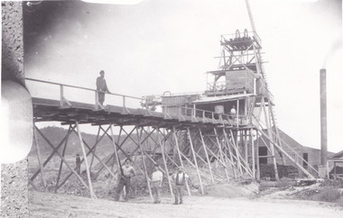
This image taken between 1920-1930 depicts open-cut hydraulic sluicing at the Three Mile Mine, located about five kilometres south of Beechworth. Alluvial, or surface, mining began on this site in the 1850s, but was soon replaced by hydraulic sluicing methods. By the start of 1880 it is estimated that nine hundred miles of water races had been cut though soil and rock in the Beechworth district. Hydraulic sluicing employs high pressure jets of water to blast away large areas of earth and wash it down to be run through a sluice box. Gold gets caught in the sluice and the remaining slurry is washed away. Large water quantities were required for hydraulic sluicing, and the long water races and deep tailraces that were constructed were considered great engineering feats. This method of mining is extremely effective, but causes significant environmental damage and impacts to waterways and agricultural operations. Miners at Beechworth built extensive networks of races and dams to secure reliable supplies of water on a scale far greater than elsewhere in Victoria. By the 1880s Beechworth's water barons continued to hold more than half of all the water right licences on issue and undertook sluicing operations on a massive scale. The manipulation of surface and ground water via race networks was well planned and recorded in detail by local mining surveyors. The maps that were created, combined with modern geo-spatial technologies, provide a vital key in understanding the great lengths to which miners went to capture and control critical water resources. Today, Three Mile mine is called Baarmutha. The Three Mile Mine was unproductive until 1865 when John Pund and three other miners secured a fifteen year license and constructed a water race from Upper Nine Mile Creek to Three Mile Creek. In the early twentieth century Pund & Co. averaged over one thousand ounces of gold per year from the mine. After Pund's death in 1915, GSG Amalgamated Co operated the site, continuing sluicing until 1950. This image of hydraulic sluicing methods shows the extent of water-works engineering in the landscape. This photograph has historic and research potential for understanding changes to the landscape, the evolution of mining methods, and the extensive construction, manipulation and management of water networks in the Beechworth district. Black and white rectangular photograph on matte paperReverse: 7597-1 / Sluice Mining / Copied from original on loan from Webb (Qld) / Donated Nov 2009 / Baarmutha Three Mile Mine c1920-1950 / Managed by the Plain Bros then Parkinsons / Current Location is: Beechworth Animal Shelter / used for Baarmuthaburke museum, beechworth museum, beechworth, gold fields, gold rush, victorian gold rush, hydraulic sluicing, spring creek, netwown falls, mining tunnels, water races, tailraces, gold ming history, colonial australia, australian gold rushes, mining technology, beechworth historic district, indigo gold trail, indigo shire, john pund, water manipulation, water engineering, three mile creek, three mile mine, water race, large-scale mining methods, historical mining construction, alluvial mining, mining environmental impacts, baarmutha, water barons -
 The Beechworth Burke Museum
Photograph, 1857
This photograph is of old mine workings on the site of the Spring Creek diggings. Spring Creek is a contact zone for granite pluton and siltstones, shales and standstones; which has, over time, encouraged natural springs to form. Enriched with gold washed out of the surrounding granite, these alluvial deposits achieved fame from 1852 onwards as the Spring Creek Diggings sprang to life (not realised as geographically important until 1871). In Spring Creek that runs behind the main street of Beechworth, near the foot of Newtown Hill a pint pot of gold was discovered on one of these expeditions in 1852 by prospectors Baker and Strickland and the gold rush town of Spring Creek was formed. Australian gold rushes have always created a sense of independence and freedom; as do-it-yourself, off-grid, low-tech adventures. People of all backgrounds were drawn to the gold fields by the prospect of riches and adventure, but they also learned self-sufficiency and found freedom of expression. Industry boomed, new practices were adopted and social norms were upended. This image is of historical significance as it informs on the history of Australian gold mining. It represents the innovation that accompanied the mining industry and the importance of gold mining in town building and regional histories. Black and white rectangular photograph on unmounted board.gold mining, spring creek, mining, geography, geology -
 Federation University Historical Collection
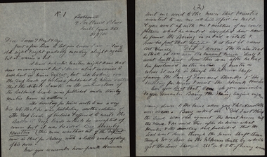
Letter, Letters from Richard Squire to his son Tom 1936
In 1905 Richard Squire was manager of the West Berry Consuls at Allendale, and developed an improved system of mine ventilation, which was supported in "The Age." He was successful in combating and remedying the gas and ventilation troubles of the Deep Mines of Creswick and Allendale Districts after all had failed. MINE MANAGERS’ ASSOCIATION. Ballarat Branch. ... Mr. R. B. Squire, manager of the West Berry Consuls, at Allendale, submitted a paper detailing what he had done tor the betterment of ventilation in the alluvial mines of Smeaton and Mary borough districts- Members gave Mr. Squire every credit for the results that he claimed to have affected; the adoption of his ideas had testified to their value to mine-owners. It was painted out, however, that for want of a thorough debate of the subject with experienced men the author had unwittingly included some general statements that required modifying in some points and extending in others, in justice to other workers among the earlier and the present-day managers of mines. It was decided to invite the author to meet a sub-committee on this subject!Various letters written by Richard Squire to his son Tom on the topic of their Mine in 1936 richard squire, tom squire, hazel squire, jack squire, jim squire, ned, mt mercer, basil, plant, skids, pump, c. hayes, illness, poppet, carburetor, shaft, balance weight, pearson, pulleys, syndicate, goon, suction, lease, reports, estimates, flat fields, reef, trucks, pipeclay, sandstone, suction pipe, valves, honeycomb rock, mr kermode, yarrowee, ballarat, reef combs, cheques, yellow slate, leigh river, dyke, quartz, ballarat deep leads, ballarat deep leads extension, bore, reads, bedrock, cemented sand, g m of a, gold mines of australia, liz the car, geoff squire, lode, cameron and sutherland, lancaster, harman, hayes timber, t. hood, alan squire, catarrh, kidney disease, stomach issues, ethel, measles, scarlet fever, ross creek field, j. bourke, j. cock, ross creek gold mining co., frank herman, hogan & banagwanath, hogan, banagwanath, napolean deap lead, hanlons, lillas, martin, jack hayes, diptheria, anticline, mr mcnichol, ronaldson, bob allan, jenkins, hunter, wilkinson, eyres brothers, g.gay & co, buninyong, llewellen, glenfine, the star mine of avoca fields, talbot alluvials, g.e. dickenson, guildford plateau, a.b.c. special supply store, jelbart, geological branch, shell coy, mr horsefields, lawaluk, almanac, trenery, barry, mining -
 Federation University Historical Collection
Letter, Letters written by Richard Squire to his son Tom Squire 1937
In 1905 Richard Squire was manager of the West Berry Consols at Allendale, and developed an improved system of mine ventilation, which was supported in "The Age."[4] He was successful in combating and remedying the gas and ventilation troubles of the Deep Mines of Creswick and Allendale Districts after all had failed. MINE MANAGERS’ ASSOCIATION. Ballarat Branch. ... Mr R. B. Squire, manager of the West Berry Consols, at Allendale, submitted a paper detailing what he had done tor the betterment of ventilation in the alluvial mines of Smeaton and Mary borough districts- Members gave Mr Squire every credit for the results that he claimed to have effected; the adoption of his ideas had testified to their value to mine-owners. It was painted out, however, that for want of a thorough debate of the subject with experienced men the author had unwittingly included some general statements that required modifying in some points and extending in others, in justice to other workers among the earlier and the present day managers of mines. It was decided to invite the author to meet a sub-committee on this subject!A variety of Letters written by Richard Squire to his son Tom Squire about the goings on at Mt Mercer Mine 1937richard squire, tom squire, hazel squire, jack squire, jim squire, ned, mt mercer, plant, skids, pump, poppet, carburetor, shaft, balance weight, pulleys, syndicate, suction, lease, reports, estimates, flat fields, reef, trucks, pipeclay, sandstone, suction pipe, valves, honeycomb rock, yarrowee, ballarat, reef combs, cheques, yellow slate, leigh river, dyke, quartz, ballarat deep leads, ballarat deep leads extension, bore, reads, bedrock, cemented sand, g m of a, gold mines of australia, liz the car, geoff squire, lode, cameron and sutherland, hayes timber, alan squire, ethel, ross creek field, ross creek gold mining co., frank herman, lillas, jack hayes, eyres brothers, g.gay & co, buninyong, glenfine, the star mine of avoca fields, talbot alluvials, guildford plateau, a.b.c. special supply store, geological branch, shell coy, lawaluk, almanac, mcbinny, bingley's paddock, cargaire valley and lead, stand and deliver demands, sheehan's, smeaton hotel, john charleson, aleck charleson, ted brown, billy jordan, mr banks, ballarat main lead, binney, goon, illabrook, mrs trenery, bre, max, june, mary, len, barry, hunter, herman, martin, aunt annie, bella, pitfield coy, mcnaughtons, donaldson, dereel, hogan, the bay leads, avoca field, ballarat alluvials, neil cameron, haddon field, courier, tom cotton, llewellen, stanley hunter, mr leonard, tom mitchell, school of mines, bryant, a.c. connely, dodson, constable mcmullins, adam ronaldson, bewick mining & co., reginald murray, r.c. selwyn, craig's hotel, broken hill syndicate, morrison's lead, wilkinson, j. hayes, mr nichol, burglary, baragwanath, wilkinson ross, creswick, seville, mr. ross, o'connor, c. mcgrath, alfred mica smith, henderson ross, angus kelly, a. r. dodson, duke of wellington plant, the moorabool lead, williams, paralysis, woodlock, squire, whipp, joe williams, peacock, moran, buchanan, hoare, bree kutchel, kohinoor band and alluvian, star of the east, bonshaw, epidemic, polio, mining -
 Federation University Historical Collection
Letter, Letters written by Richard Squire to his son Tom Squire 1938
In 1905 Richard Squire was manager of the West Berry Consols at Allendale, and developed an improved system of mine ventilation, which was supported in "The Age."[4] He was successful in combating and remedying the gas and ventilation troubles of the Deep Mines of Creswick and Allendale Districts after all had failed. MINE MANAGERS’ ASSOCIATION. Ballarat Branch. ... Mr R. B. Squire, manager of the West Berry Consols, at Allendale, submitted a paper detailing what he had done tor the betterment of ventilation in the alluvial mines of Smeaton and Mary borough districts- Members gave Mr Squire every credit for the results that he claimed to have effected; the adoption of his ideas had testified to their value to mine-owners. It was painted out, however, that for want of a thorough debate of the subject with experienced men the author had unwittingly included some general statements that required modifying in some points and extending in others, in justice to other workers among the earlier and the present day managers of mines. It was decided to invite the author to meet a sub-committee on this subjectHandwritten letters written by Richard Squire to his son Tom Squire 1938 on lined paperrichard squire, tom squire, hazel squire, jack squire, jim squire, ned, mt mercer, plant, skids, pump, poppet, carburetor, shaft, balance weight, pulleys, syndicate, suction, lease, reports, estimates, flat fields, reef, trucks, pipeclay, sandstone, suction pipe, valves, honeycomb rock, yarrowee, ballarat, reef combs, cheques, yellow slate, leigh river, dyke, quartz, ballarat deep leads, ballarat deep leads extension, bore, reads, bedrock, cemented sand, g m of a, gold mines of australia, liz the car, geoff squire, lode, hayes timber, ethel, ross creek field, ross creek gold mining co., frank herman, lillas, jack hayes, eyres brothers, g.gay & co, buninyong, glenfine, the star mine of avoca fields, talbot alluvials, guildford plateau, a.b.c. special supply store, geological branch, shell coy, lawaluk, almanac, mcbinny, bingley's paddock, cargaire valley and lead, stand and deliver demands, sheehan's, smeaton hotel, john charleson, ballarat main lead, goon, dereel, the bay leads, avoca field, ballarat alluvials, haddon field, courier, school of mines, bewick mining & co., broken hill syndicate, morrison's lead, baragwanath, creswick, duke of wellington plant, the moorabool lead, kohinoor band and alluvian, star of the east, bonshaw, epidemic, polio, k.w. steedman, mr newman, allendale mines, professor mica smith, alfred mica smith, mr hodge, w. taylor, mcpherson's reward coy, mr mitchell, billy thomas, john bull, albert, nina, stanley hunter, frederick the great, ross creek south, bislolo, brilolo, birlolo, ballarat east coy, maxwells, reginald murray, bob allan, vendetta, john lynch, dodson, mnster of mines, e.j. hogan, jonah ward, mcnaughton's paddock, bellesby, alec peacock, jenkins, h.c. jenkins, conspiracy, argus, mr ellerby, dr lawrence, occulist, mining -
 Marysville & District Historical Society
Booklet (item) - Information booklet, Artworkz Tourism, Gold & Mining, Unknown
A booklet that was produced of information regarding gold and gold mining in Australia.A booklet that was produced of information regarding gold and gold mining in Australia.gold, gold mining, californian gold rush, australian gold rush, new south wales gold rush, victorian gold rush, eureka stockade, redgate diggings, eglington mine, redgate, alexandra, alluvial mining, quartz reef mining, walhalla quartz reef mine, mount pleasant diggings, artworks tourism -
 Eltham District Historical Society Inc
Negative - Photograph, Carl Walter 1831-1907, Coffer dam in the Yarra River at Anderson's Creek, 1864
1864 photograph of the Coffer Dam in the River Yarra situated (approximately) opposite Whipstick Gully. Remains of bridge built in 1860(?) wrecked by 1863 flood in background. Reproduced page 29 of ‘Pioneers & Painters’ Gold was first discovered in this area at Andersons Creek (Warrandyte) in June 1851 by Louis Michel. Discoveries north of the Yarra did not occur until about 1854. Although it took some months for a true rush to develop it was not long before alluvial workings were being carried on in most of the Shire of Eltham. The last area in which gold was discovered was Kinglake. As the gold became harder to find, deep mining took over from alluvial diggings in the gullies. Perhaps the most extensive of the deep workings was the Diamond Creek Mine just outside the boundary of the Shire. This form of mining was continued into the 1930s. There are believed to be some mines in the area still capable of producing gold but present prices make working these uneconomical. Some gold is still found by weekend prospectors. Photo: Carl Walter 1831-1907 – inscribed on tent “C. Walter Photo” The State Library of Victoria holds over 150 photos by Carl Walter, most of which are portraits of Aboriginal natives including William Barak.This photo forms part of a collection of photographs gathered by the Shire of Eltham for their centenary project book,"Pioneers and Painters: 100 years of the Shire of Eltham" by Alan Marshall (1971). The collection of over 500 images is held in partnership between Eltham District Historical Society and Yarra Plenty Regional Library (Eltham Library) and is now formally known as 'The Shire of Eltham Pioneers Photograph Collection.' It is significant in being the first community sourced collection representing the places and people of the Shire's first one hundred years.Digital image 4 x 5 inch B&W Neg (2) Print 20 x 25 cmshire of eltham pioneers photograph collection, anderson's creek, coffer dam, floods, gold mining, other areas, pioneers and painters, warrandyte, warrandyte bridge, yarra river -
 Federation University Historical Collection
Book, Mines and Minerals: A Guide for the Australian Miner, 1885
This book was presented to Professor Ferdinand Krause of the Ballarat School of Mines by the co-author Felix Ratte who had taught Geology at the Ballarat School of Mines. Felix Ratte became mineralogist to the Australian Museum, Sydney.Hardcovered book with brown cloth cover. 341 pages with illustrations. Chapters in the book include Geology; Rocks and their Movements; Stratified Deposits; Mineral Veins and Lodes; Dynamics of Lodes; Filling of Lodes; Irregular Deposits; Alluvial Deposits; Physical Properties of Minerals; Compsition and Determination of Minerals; Noble Mineral; Silver and Lead; Quicksilver or Mercury; Haloids and salts; Quartz and Opal; Precious stones; assays and the use of Blowpipes; Special Assays for Gold and SilverFrontise page handwritten in ink: 'Prof. Krause from F. Ratte'mining, ballarat school of mines, geology, felix ratte, minerals, ferdinand krause -
 Federation University Historical Collection
Book, Guide for Prospectors in Victoria, 1931, 1931
The handbook was intended for those with little experience who wanted to prospect of fossick.Grey soft covered book of 90 pages. Includes fold out map of a portion of Victoria showing auriferous areas and mineral localities. Also show Counties of Victoria and localities of minerals such as tin, antimony, copper, silver lead, Malybdenite, tungsten ores, manganese, platinum, osmiridium and iron. Chapter heading s include: working alluvial deposits, equipment, geology of Victoria, gold deposits, quartz reefs, indicators, economic minerals, assistance to prospectors, Miners' Right, mining bye-law, mining leases, forest regulations and glossary. Descriptions are given of a god dish, puddling tub, cradle, puddling machine, ground sluicing, boring, windlass, whim, hand dollying, sweeping, California pump, and wing dam.mining, baragwanath, gold, prospector, geology, quartz reefs, alluvial deposits, indicators, victorian goldfields, miners rights, mining leases, forest regulations, sluicing, sluice box, puddling machine, miner's cradle, whim, whip, california pump, gold nuggets, saddle reef, ballarat indicators, state batteries -
 Federation University Historical Collection
Book, Albert J. Mullett, List of Nuggets found in Victoria, 1912
Pink soft covered foolscap book of 67 pages listing the gold nuggets found in Victoria. The Book is no 12 in the 'Memoirs of the Geological Survey of Victoria' series. The listing of nuggets found in Victoria includes number of nugget, whether found in quartz or alluvial, weight, where found, depth, name of nugget. date found, finders, authority and remarks. 1360 nuggets weighing over 20 ozs are listed.geological survey of victoria, gold nuggets, e.j. dunn, w. dickson, peter mcbride, a. e. smith, tinworth's party, welcome stranger, ah chung, dalton's flat, lady hotham, lady don, lady barkly, needful, corinella mining co, w. kitt, p. flood, celeste lafranchi, bravo, w. passobi, mrs rowlands -
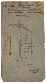 Federation University Historical Collection
Plan, Lease by Charles Edwin House, 1899, 1899
... charles house gold lease ballarat alluvial claim Plan on waxed ...Plan on waxed linen for a lease by Charles Edwin House.house, charles house, gold lease, ballarat, alluvial claim -
 Federation University Historical Collection
Book, Memoirs of the Geological Survey of Victoria No 14 The Ballarat Goldfields, 1923, 1923
William Baragwanath was educated at the Ballarat School of Mines, obtaining a Geology Certificate in 1911. After further study he went on the become Secretary for Mines, and Chief Mining Surveyor. Baragwanath was a Councillor of the Ballarat School of Mine from 1916 to 1950.Pink covered foolscap book of 257 pages and 32 maps and plans by William Baragwanath. Contents include topography, physiography, historical, geology, basalt, faults, dykes, minerals leads, alluvial mines, nuggets, structure of Ballarat West goldfields, structure of Ballarat East gold-field, quartz formation, indicators, defunct mines, existing mines, table of deepest shafts. Images include: section of the Ballarat Gold-Field, Dead HOrse Flat, lakes formed by Basalt Flows, Gong Gong Creek, Frenchman's Lead, Ballarat West Mines, LEases and positions of shafts (1857), puddling, White Horse Lead, Woah Hawp Canton, Ballarat Township mines, Sebastopol, syncline, Victoria United Line, First Chance Mine, Llanberris No 1 Mine, Saddle Reef, New Normanby Mine, Woah Hawp Canton Mine, South Star Mine, Sebastopol Plateau, south Woah Hawp Mine, Woah No. 2 Minegeology, geological survey no 14, ballarat, baragwanath, william baragwanath