Showing 47 items
matching argyle avenue
-
 Chelsea & District Historical Society Inc
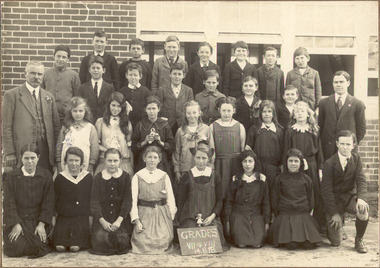
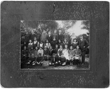
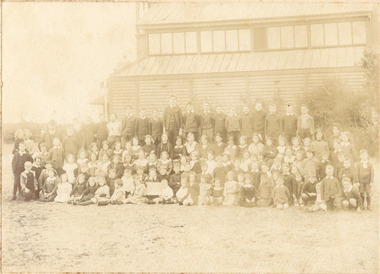
Photograph - Chelsea State School, Grade VII & VIII, 4 August 1918
... Chelsea State School was built on Argyle Avenue...Chelsea State School was built on Argyle Avenue ...Chelsea State School was built on Argyle Avenue and officially opened on 27 January 1915.Black and white photo of Mr G. Rogers, the Head Teacher, a male teacher, GradesVII and VIII at Chelsea State School, on 14 August 1918chelsea, education, chelsea primary school, school, chelsea state school, grade 7, grade 8 -
 Chelsea & District Historical Society Inc
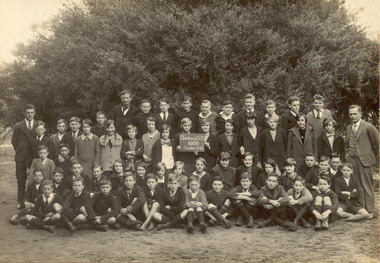
Photograph - Chelsea State School, Grade 7 & 8, 1928
... Chelsea State School was built on Argyle Avenue...Chelsea State School was built on Argyle Avenue ...Chelsea State School was built on Argyle Avenue and officially opened on 27 January 1915.Black and white photo of Grades 7 and 8 at Chelsea State School, in 1928chelsea, education, chelsea primary school, school, chelsea state school, grade 7, grade 8 -
 Chelsea & District Historical Society Inc
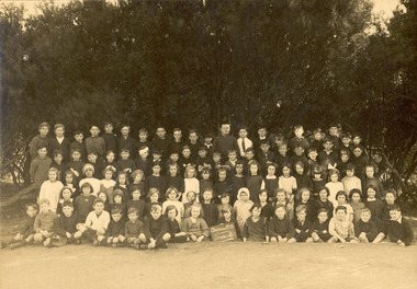
Photograph - Chelsea State School, Grade 3, c 1920's
... Chelsea State School was built on Argyle Avenue...Chelsea State School was built on Argyle Avenue ...Chelsea State School was built on Argyle Avenue and officially opened on 27 January 1915.Sepia photo of Grade 3 at Chelsea State School. chelsea, education, chelsea primary school, school, chelsea state school, grade 3 -
 Chelsea & District Historical Society Inc
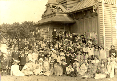
Photograph - Chelsea State School, Students at Kismet Hall, Chelsea, 1925
... Chelsea State School was built on Argyle Avenue...Chelsea State School was built on Argyle Avenue ...Chelsea State School was built on Argyle Avenue and officially opened on 27 January 1915. Kismet Hall was located in The Strand, Chelsea.Sepia photo of students of Chelsea State School, in front of Kismet Hall. The teacher is Miss Cooper. chelsea, education, chelsea primary school, school, chelsea state school, kismet hall -
 Chelsea & District Historical Society Inc
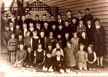
Photograph - Chelsea State School, Grade 6, 1920
... school was built on Argyle Avenue and officially opened on 27... school was built on Argyle Avenue and officially opened on 27 ...In January 1912, a small school was established at Chelsea, with 65 students, in Hoadley’s Hall, located on Main Road, Chelsea, near the Nepean Highway. Due to its Oriental appearance, the local people called this hall “The Joss House.” A new brick school was built on Argyle Avenue and officially opened on 27 January 1915.Black and white photo of Grade 6 children at Chelsea State School, in 1920, with the Headmaster, George Rogerschelsea, education, grade 6, george rogers, school, chelsea state school -
 Chelsea & District Historical Society Inc
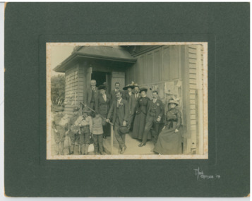
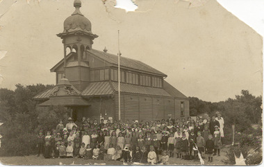
Photograph - Chelsea State School, Parents Committee at "Joss House", 1914
... school was built on Argyle Avenue and officially opened on 27... school was built on Argyle Avenue and officially opened on 27 ...In January 1912, a small school was established at Chelsea, with 65 students, in Hoadley’s Hall, located on Main Road, Chelsea, near the Nepean Highway. Due to its Oriental appearance, the local people called this hall “The Joss House.” A new brick school was built on Argyle Avenue and officially opened on 27 January 1915.Black and white photo Parents Committee of Chelsea State School, in front of the school with four scouts with English flags.chelsea, education, chelsea primary school, school, parents committee, scouts, joss house, chelsea state school -
 Chelsea & District Historical Society Inc
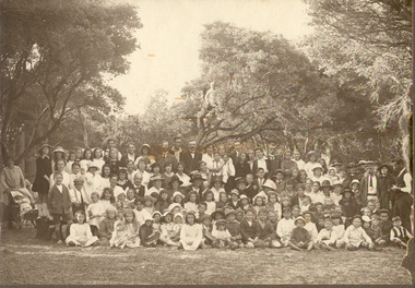
Photograph - Chelsea State School, Students, staff and Family on a picnic, c 1912-14
... brick school was built on Argyle Avenue and officially opened... brick school was built on Argyle Avenue and officially opened ...In January 1912, a small school was established at Chelsea, with 65 students, in Hoadley’s Hall, located on Main Road, Chelsea, near the Nepean Highway. Due to its Oriental appearance, the local people called this hall “The Joss House.” Hoadley's Hall was was originally used at the Melbourne Show Grounds by Hoadley's which was moved to Chelsea. The Hall was also used for church services by different religions before they built their own churches. A new brick school was built on Argyle Avenue and officially opened on 27 January 1915.Sepia photo of children, staff and family from Chelsea State School, at a picnic, amongst the te trees.chelsea, education, chelsea primary school, school, hoadleys hall, joss house, picnic, te trees -
 Chelsea & District Historical Society Inc
Photograph - Chelsea State School, Children outside Hoadleys Hall "Joss House", 1912
... brick school was built on Argyle Avenue and officially opened... brick school was built on Argyle Avenue and officially opened ...In January 1912, a small school was established at Chelsea, with 65 students, in Hoadley’s Hall, located on Main Road, Chelsea, near the Nepean Highway. Due to its Oriental appearance, the local people called this hall “The Joss House.” Hoadley's Hall was was originally used at the Melbourne Show Grounds by Hoadley's which was moved to Chelsea. The Hall was also used for church services by different religions before they built their own churches. A new brick school was built on Argyle Avenue and officially opened on 27 January 1915.Black and white photo of children at Chelsea State School, in 1912, standing in front of Hoadley's Hall.chelsea, education, chelsea primary school, school, hoadleys hall, joss house -
 Chelsea & District Historical Society Inc
Photograph - Chelsea State School, Children outside Hoadleys Hall "Joss House", 1914
... brick school was built on Argyle Avenue and officially opened... brick school was built on Argyle Avenue and officially opened ...In January 1912, a small school was established at Chelsea, with 65 students, in Hoadley’s Hall, located on Main Road, Chelsea, near the Nepean Highway. Due to its Oriental appearance, the local people called this hall “The Joss House.” Hoadley's Hall was was originally used at the Melbourne Show Grounds by Hoadley's which was moved to Chelsea. The Hall was also used for church services by different religions before they built their own churches. A new brick school was built on Argyle Avenue and officially opened on 27 January 1915.Sepia photo of children and adults at Chelsea State School, in 1914, standing in front of Hoadley's Hall.chelsea, education, chelsea primary school, school, hoadleys hall, joss house, chelsea state school -
 Chelsea & District Historical Society Inc
Photograph - Chelsea State School, Children outside Hoadleys Hall "Joss House", 1912
... brick school was built on Argyle Avenue and officially opened... brick school was built on Argyle Avenue and officially opened ...In January 1912, a small school was established at Chelsea, with 65 students, in Hoadley’s Hall, located on Main Road, Chelsea, near the Nepean Highway. Due to its Oriental appearance, the local people called this hall “The Joss House.” Hoadley's Hall was was originally used at the Melbourne Show Grounds by Hoadley's which was moved to Chelsea. The Hall was also used for church services by different religions before they built their own churches. A new brick school was built on Argyle Avenue and officially opened on 27 January 1915.Sepia photo of children and adults at Chelsea State School, in 1912, standing in front of Hoadley's Hall.chelsea, education, chelsea primary school, school, hoadleys hall, joss house, chelsea state school -
 Chelsea & District Historical Society Inc
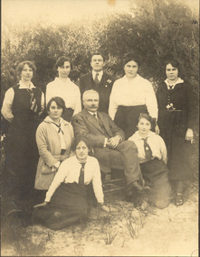
Photograph - Chelsea State School, Mr Rogers with staff and family, 1918
... State School was built on Argyle Avenue and officially opened... State School was built on Argyle Avenue and officially opened ...In January 1912, a small school was established at Chelsea, with 65 students, in Hoadley’s Hall, located on Main Road, Chelsea, near the Nepean Highway. Due to its Oriental appearance, the local people called this hall “The Joss House.” Hoadley's Hall was was originally used at the Melbourne Show Grounds by Hoadley's which was moved to Chelsea. The Hall was also used for church services by different religions before they built their own churches. Chelsea State School was built on Argyle Avenue and officially opened on 27 January 1915.Sepia photo of Mr Rogers, his staff and family. Mr Rogers was the first Head teacher of Chelsea State School from 1912 to 1917.chelsea, education, chelsea primary school, school, students, school yard, mr rogers, teachers, chelsea state school -
 Kew Historical Society Inc
Plan - Subdivision Plan, Jas R Mathers Son & McMillan, East Kew Tramway Estate, 1915
... . The larger section included 54 lots facing Adeney Avenue, Argyle Road.... The larger section included 54 lots facing Adeney Avenue, Argyle Road ...Pru Sanderson, in her groundbreaking ‘City of Kew Urban Conservation Study : Volume 2 - Development History’ (1988), summarised the periods of urban development and subdivisions of land in Kew. The periods that she identified included 1845-1880, 1880-1893, 1893-1921, 1921-1933, 1933-1943, and Post-War Development. These periods were selected as they represented periods of rapid growth or decline in urban development. An obvious starting point for Sanderson’s groupings involved population growth and the associated economic cycles. These cycles also highlighted urban expansion onto land that was predominantly rural, although in other cases it represented the decline and breakup of large estates. A number of the plans in the Kew Historical Society’s collection can also be found in other collections, such as those of the State Library of Victoria and the Boroondara Library Service. A number are however unique to the collection.The Kew Historical Society collection includes almost 100 subdivision plans pertaining to suburbs of the City of Melbourne. Most of these are of Kew, Kew East or Studley Park, although a smaller number are plans of Camberwell, Deepdene, Balwyn and Hawthorn. It is believed that the majority of the plans were gifted to the Society by persons connected with the real estate firm - J. R. Mathers and McMillan, 136 Cotham Road, Kew. The Plans in the collection are rarely in pristine form, being working plans on which the agent would write notes and record lots sold and the prices of these. The subdivision plans are historically significant examples of the growth of urban Melbourne from the beginning of the 20th Century up until the 1980s. A number of the plans are double-sided and often include a photograph on the reverse. A number of the latter are by noted photographers such as J.E. Barnes.The East Kew Tramway Estate was a subdivision of two separate parcels of land between Adeney Avenue and Normanby Road. The larger section included 54 lots facing Adeney Avenue, Argyle Road, and Campbell, Hunter and Wishart Streets. [Hunter and Wishart Streets were created as part of the subdivision.] A further 17 allotments faced Normanby Road, Hubert and Campbell Streets. [The name of Hubert Street was later to be changed to Cecil Street.] The promotion of the sale referred to the advantages of living between two tram routes, in High Street and Cotham Road. On the plan, quaintly drawn trams mark these routes. Also on the plan is the route of part of the Outer Circle [Railway] Line.east kew tramway estate, subdivision plans - east kew -
 Kew Historical Society Inc
Plan - Subdivision Plan, Normanby Heights Estate, Kew, 1919
... pleasant avenue, normanby road, argyle street... to attract purchasers to the auction of 17 lots facing Argyle Street... pleasant avenue, normanby road, argyle street The Normanby Heights ...Prue Sanderson, in her groundbreaking ‘City of Kew Urban Conservation Study : Volume 2 - Development History’ (1988), summarised the periods of urban development and subdivisions of land in Kew. The periods that she identified included 1845-1880, 1880-1893, 1893-1921, 1921-1933, 1933-1943, and Post-War Development. These periods were selected as they represented periods of rapid growth or decline in urban development. An obvious starting point for Sanderson’s groupings involved population growth and the associated economic cycles. These cycles also highlighted urban expansion onto land that was predominantly rural, although in other cases it represented the decline and breakup of large estates. A number of the plans in the Kew Historical Society’s collection can also be found in other collections, such as those of the State Library of Victoria and the Boroondara Library Service. A number are however unique to the collection.The Kew Historical Society collection includes almost 100 subdivision plans pertaining to suburbs of the City of Melbourne. Most of these are of Kew, Kew East or Studley Park, although a smaller number are plans of Camberwell, Deepdene, Balwyn and Hawthorn. It is believed that the majority of the plans were gifted to the Society by persons connected with the real estate firm - J. R. Mathers and McMillan, 136 Cotham Road, Kew. The Plans in the collection are rarely in pristine form, being working plans on which the agent would write notes and record lots sold and the prices of these. The subdivision plans are historically significant examples of the growth of urban Melbourne from the beginning of the 20th Century up until the 1980s. A number of the plans are double-sided and often include a photograph on the reverse. A number of the latter are by noted photographers such as J.E. Barnes.The Normanby Heights Estate not unusually used hyperbole to attract purchasers to the auction of 17 lots facing Argyle Street (sic), Pleasant Avenue and Normanby Road. Predictably factors appealed to included the proximity to schools etc, the availability of public utilities, friable soil, picturesque views and ‘advancing settlement’. If that were not enough, the sales pitch exhorted prospective purchasers to consider their backbone. ‘Thrift is unquestionably the Backbone of any Nation. No better form of Thrift can be encouraged in the young citizen than by investing his or her savings in a piece of land in a growing, healthy and beautiful locality. NORMANBY HEIGHTS ESTATE admirably fits the need.’ The experience of Australia at war undoubtedly contributed to the use of terms such as ‘Backbone of a Nation’ and the appeal to egalitarian principles in the choice of the term ‘young citizen’. The recognition that women had savings and might be the prospective purchaser also reflects a new sense of the rights and entitlements of women in the postwar period.subdivision plans - kew, normanby heights estate, pleasant avenue, normanby road, argyle street -
 Kew Historical Society Inc
Archive (Sub-series) - Subject File, Kew Historical Society, Gardens (Kew), 1979
... of Argyle Road and Victor Avenue, Merridale, Sackville Street... of Argyle Road and Victor Avenue, Merridale, Sackville Street ...Various partiesReference, Research, InformationSecondary Values (KHS Imposed Order)Correspondence and newspaper articles/clippings relating to historic gardens in Kew. The oldest item is a letter from the National Trust Victoria announcing their two-year garden study and seeking information on gardens in Kew. Mavis Rolley, Secretary of the Society, made handwritten notes in response, which are kept in the file. She refers to: the pear trees planted by William Oswin in c. 1845 near what is now the Burke Road Bridge (she notes that a search for the trees at the time of the construction of the Eastern Freeway was unsuccessful), a camellia planted by the Dannocks near the corner of Derby and High Street, a c.1876 pine tree in Field Place, Henty Court, an 1875 Moreton Bay fig at Tarring, Ruyton, a Moreton Bay fig at Roxeth, Trinity Grammar, an 1840s oak tree and a 120-year old olive tree at Fairholme, Barry Street, 1870 pine trees at D’Estaville, Barry Street, trees at Turinville, Barnard Grove, dating to 1846, pine trees dating from 1845-6 on the Willsmere Farm, red gums in Victoria Park, pine trees in the Cemetery dating from the 1860s, trees in the Alexandra Gardens and at Kew Primary School, palm trees at La Verna, Sackville Street dating from the 1890s, the trees and gardens at Ross House (Charleville), and the trees at Merridale, Sackville Street which date from the 1880s, a magnolia at Lalla Rookh. These dates are probably highly contestable. Other handwritten notes from 1979 about significant gardens included: 5 Molesworth Street, Red Bluff - Redmond Street (garden now destroyed), Campion House, Studley Park Road, Raheen, Studley Park Road, Ross House, Cotham Road (Charleville), 7 Adeney Avenue, 20-21 Belmont Avenue, 52 Mary Street, an Edna Walling garden on the corner of Argyle Road and Victor Avenue, Merridale, Sackville Street, Roseneath, and Reno, St John’s Parade.gardens - private - kew (vic), garden design - kew (vic), kew horticultural societygardens - private - kew (vic), garden design - kew (vic), kew horticultural society -
 Kew Historical Society Inc
Plan - Subdivision Plan, Argyle Road, Heather Grove, Victor Avenue, Kew, c.1937
The Kew Historical Society's map collection includes a substantial number of real estate subdivision plans, mainly of Kew but also of surrounding suburbs in Melbourne. Most of the subdivision plans date from the 1920s and 1930s when the districts old homes and local farmland were being split up to accommodate residential growth in the postwar period. These early plans were assembled by a local firm, Jas R Mather & McMillan, which had an office in Cotham Road. Many of the plans, and sometimes photos, were annotated by the agents.Subdivision plans are historically important documents used as evidence for the growth of suburbs in Australia. They frequently provide information about when the land was sold as well as evidence relating to surveyors and real estate and financial agents. The numerous subdivision plans in the Kew Historical Society's collection represent working documents, ranging from the initial sketches made in planning a subdivision to printed plans on which auctioneers or agents listed the prices for which individual lots were sold. In a number of cases, the reverse of a subdivision plan in the collection includes a photograph of a house that was also for sale by the agent. These photographs provide significant heritage information relating house design and decoration, fencing and household gardens.The photograph may also be aesthetically significant depending on the importance of the photographic atelier.Undated blue subdivision plan in Kew of 14 lots facing Argyle Road, Heather Grove and Victor Road. The Plan identifies Tuxen & Miller as the surveyors. [Formerly catalogued as MAP.0059]subdivision plans - kew, argyle road - kew, heather grove - kew, victor avenue - kew -
 Kew Historical Society Inc
Plan - Subdivision Plan, Goldthorns Hill Estate, 1925
Pru Sanderson, in her groundbreaking ‘City of Kew Urban Conservation Study : Volume 2 - Development History’ (1988), summarised the periods of urban development and subdivisions of land in Kew. The periods that she identified included 1845-1880, 1880-1893, 1893-1921, 1921-1933, 1933-1943, and Post-War Development. These periods were selected as they represented periods of rapid growth or decline in urban development. An obvious starting point for Sanderson’s groupings involved population growth and the associated economic cycles. These cycles also highlighted urban expansion onto land that was predominantly rural, although in other cases it represented the decline and breakup of large estates. A number of the plans in the Kew Historical Society’s collection can also be found in other collections, such as those of the State Library of Victoria and the Boroondara Library Service. A number are however unique to the collection.The Kew Historical Society collection includes almost 100 subdivision plans pertaining to suburbs of the City of Melbourne. Most of these are of Kew, Kew East or Studley Park, although a smaller number are plans of Camberwell, Deepdene, Balwyn and Hawthorn. It is believed that the majority of the plans were gifted to the Society by persons connected with the real estate firm - J. R. Mathers and McMillan, 136 Cotham Road, Kew. The Plans in the collection are rarely in pristine form, being working plans on which the agent would write notes and record lots sold and the prices of these. The subdivision plans are historically significant examples of the growth of urban Melbourne from the beginning of the 20th Century up until the 1980s. A number of the plans are double-sided and often include a photograph on the reverse. The Goldthorns Hill Estate subdivision was first put up for auction in 1925. The subdivision took its name from the mansion ‘Goldthorns’, shown on the plan between Normanby Road and Lady Loch’s Drive. Contemporary advertisements describe forty-three home sites being fro sale, yet only forty-one appear on this plan. Buyers were lured by the prospect of the proposed extension of the Burke Road tram to High Street. Discerning buyers were advised that only one house could be built per allotment, and that houses needed to be constructed of brick, stone or concrete and have a slate or tiled roof.goldthorns avenue -- kew east (vic.), lady loch drive -- kew east (vic.), argyle road -- kew east (vic.), lady brassey drive -- kew east (vic.), campbell street -- kew east (vic.), goldthorns -- kew (vic.), subdivisions -- kew east (viv.), goldthorns hill estate -
 Bass Coast Shire Council - Robert Smith Collection
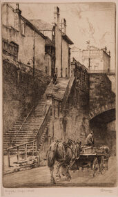
Artwork, other - Argyle Steps, Edward Warner
Etching 10/45Signed, titled and numbered