Showing 45 items
matching bluestone fence
-
 Surrey Hills Historical Society Collection
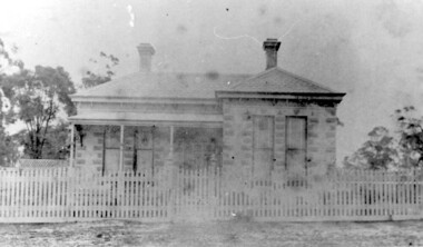
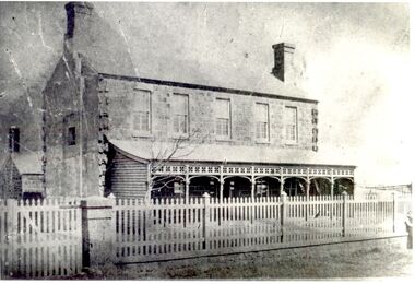
Photograph, 'Warrington', 319 Mont Albert Road, Surrey Hills
The house has been demolished but was associated with the Jacobs family. The Jacobs family lived in Surrey Hills from c 1895-1903 (ref: electoral rolls); by 1909 they were in Gippsland at Toora where Henry Atwood Jacobs was a storekeeper. They had returned to Surrey Hills by 1924 (ref: electoral roll) and were living at 22 Suffolk Road. Family details: Capt Jacobs was appointed to the Nunawading Roads Board in 1900; in 1902 he as a member of a deputation to the Minister of Public Works regarding municipal severance. He was in favour of Surrey Hills being a separate municipality. Amy (Amelia) Jacobs was the daughter of Capt Jacobs and his first wife, Eleanor Dobson Mills, who died shortly after the birth of her daughter. Winifred Atwood Jacobs was born c 1900; Mildred Adelaide Jacobs was born 1902, both at 'Spencycroft' in Canterbury Road, Surrey Hills. Winifred married Stephen Edwin Yarnold (1903-1978), a Presbyterian & Uniting Church minister, on 26 July 1946. He had a notable career in the ministry and has an ADB biography. Black and white photo of a Victorian style home with a slate roof, 2 chimneys and a veranda across 3/4 of the front. Construction is possibly block-fronted timber or bluestone and render; not brick. The house sits behind a picket fence with a lattice screen to one side. There are mature trees, possibly eucalypts in the background.warrington, house names, fences, surrey hills, architectural features, victorian style, vegetation, verandas, capt henry atwood jacobs, mrs amy lilian jacobs, miss amy lillian scales, miss amelia allan jacobs, miss winifred atwood jacobs, mrs winifred atwood yarnold, miss mildred adelaide jacobs -
 Surrey Hills Historical Society Collection
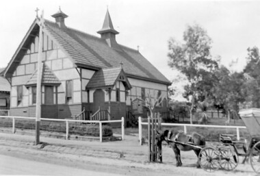
Photograph, Holy Trinity Church, Surrey Hills in the 1920s
This church was built in 1907 and became known as Holy Trinity Surrey Hills. This name had previously been used by the Anglican Church in Mont Albert Road, Mont Albert. This henceforth became known as St George's Anglican Church, Mont Albert. There are 2 copies: the original donated print and an enlargement. The original is mounted on card with photo mounts along with 890, 891 and 892. It measures 13 cm x 9 cm. Norman Carter took many photos of Surrey Hills and Mont Albert from the 1920s in particular of events and activities associated with the Church of England.Black and white photo of the original Holy Trinity Church building in Union Road. It is constructed of weatherboards, above which there is plasterboard and timber strapping. The roof is of terracotta tiles with a small steeple at the front and a larger one towards the rear of the building. There is a box bay window at the front and the entrance is from a porch on the southern side of the building. This is approached by stairs. Part of the vicarage can be seen on the northern high side of the church and to the south there is vacant land. The whole property sits behind a simple post and wire fence. There is a phaeton in the foreground beside a relatively newly planted street tree. The road has bluestone kerb and channelling.churches, holy trinity church, anglican church, horse-drawn vehicles, norman brodley carter, union road -
 Surrey Hills Historical Society Collection
Photograph, Streetscape near the corner of Victoria Crescent and Hotham Street, Surrey Hills
Prior to subdivision for housing this area was paddocks used for grazing of cattle and used as part of the course in the early days of the Surrey Hills Golf Club. Reproduced by permission of Mr John Arnold from his book: "The Riversdale Golf Club - a history, 1892-1977." Copyright to book: Riversdale Golf Club. Surrey Hills Golf Club operated from 1892-1908 then moved and became Riversdale Golf Club. The game was played across paddocks from Trafalgar Street, Mont Albert to Whitehorse Road and down Victoria Crescent to where Box Hill TAFE is now located in Elgar Road. There were problems with cows eating the tee flags! The clubhouse still exists as 30 Trafalgar Street.Black and white photo taken from the centre of a bitumen road which is flanked by bluestone guttering. Nature strips, drive cross-overs and house fences are shown. Trees on the RHS nature strip are pollarded to avoid overhead power and telephone lines. There houses in the background."Bottom: The same view today taken from the intersection of Victoria Crescent and Hotham Street, Surrey Hills."surrey hills golf club, hotham street, victoria crescent, riversdale golf club, surrey hills, john arnold -
 Vision Australia
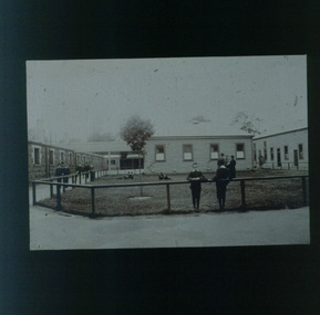
Slide - Image, Recreation area at RVIB
Image of boys and men around and in a grassed area at RVIB, that is bordered by wooden railing. A single-storey bluestone building and two wooden buildings surround the grass. Some children rest on the railing whilst others play in the grass or walk around the area. Three adults talk amongst the boys. Boys and men standing behind or by a fence bordering a grassed arearoyal victorian institute for the blind, education -
 Port Fairy Historical Society Museum and Archives
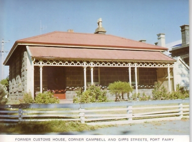
Photograph, Former Customs House Cnr Campbell & Gipps Sts
The customs house located on the corner of Campbell and Gipps Streets next door to the Court housecoloured photograph of bluestone cottage with verandah and timber rail fencesouvenir, port-fairy, customs house, campbell street, gipps street -
 Port Fairy Historical Society Museum and Archives
Photograph
The land for this building was granted to the Benevolent Society by James Atkinson in 1850. Tenders were being called for a new "Benevolent Asylum" in 1855, the foundation stone having been laid and by 1856 the first part of the Hospital was completed. This photo taken in 1860 shows the very first building made from local bluestone. The hospital is thought to be the first such building in VictoriaBlack and white photograph of Bluestone 2 story building with verandah and paling fencehospital, institution -
 Vision Australia
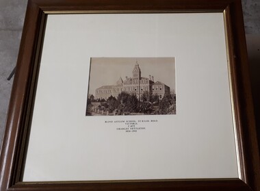
Photograph - Image, Charles Nettleton, Blind Asylum School, St Kilda Road, circa 1875
Unsubstantiated photograph of the Asylum for the Blind in 1875. The four storey bluestone building rises above a group of trees planted in the garden. A picket and wire/string fence border the unpaved circular driveway. 2 black and white images of the Guiding Light at Elanora Blind Asylum School, St Kilda Road Victoria c. 1875 Charles Nettleton 1826-1902 Spencer Scott Sandilands 546 High Street, East Preson, 3181 Melbourne, Victoria, Australia, Tel: (03) 529 8011 Fax: (03) 521 1754 33 George Street, The Rocks, 2000 Sydney, New South Wales, Australia, Tel: (02) 241 4251 Fax: (02) 2414535 Rare Prints, Antiquarian Books, Old Maps, Australiana, Antiques, Photographs, Framing c.1875 Charles Nettleton School from the Blind Original Photograph $65 Guaranteed over 100 years oldroyal victorian institute for the blind, buildings -
 Glenelg Shire Council Cultural Collection
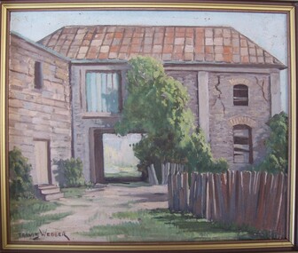
Painting, Travis Webber, Greenmount from the rear, c. 1955
Travis Webber was born in South Australia in 1900. He died in 1968. He studied at the South Australian School of Arts where he went on to teach. Webber established himself as one of the Australia's most prolific landscape artists. His work is held in several large galleries.Bluestone building with a shingle roof. In foreground right is a wooden fence. A carriageway cuts through centre of building, and above this is a window filled in with corrugated iron. The right side of building has large cracks. A tree is growing against the building in image centre, and bushes at image left and right. Framed in wooden frame.Front: Travis Webber (brown paint, lower left) Back: Geelong Picture Framers, 211 Moorabool Street, Gelong. Ph: 97805 (blue ink stamp, lower centre).oil painting, greenmount, landscape, portland landscape -
 Glenelg Shire Council Cultural Collection
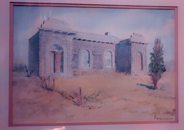
Work on paper - Watercolour, Florence Tatham Mellblom, Portland Shire Hall, n.d
From Antiques Reporter: Florence Tatham Mellblom, (Australian, 1900 - 1983), Visit Portland The First Victorian Settlement, during the Centenary Celebrations from 15th to 23rd November 1934', 1934 colour lithograph, signed 'F. Mellblom' in image lower left, 63.5 x 101.5 cm. Linen-backed. Text continues in lower margin: 'Arbuckle, Waddell Pty Ltd Print, Melb.', Mellblom (nee Henry) was a painter, naturalist and photographer. She was born at Portland, Victoria, and studied art in Ballarat. She was a talented etcher from childhood, and joined the Portland Camera club. She also produced many watercolour paintings of the historic places of Portland. She was married (1932) to Karl Enoch Mellblom.A bluestone building on an arid landscape. Yellow grass in the foreground with one tree standing at the front. There is a blue sky behind. The left hand wing has a door which is slightly open. Above each wing is an engraved piece of stone. Left - Portland, right - Shire. An old rickety fence to the left of the building.Bottom Right - F. Mellblomfemale artist, women, female, landscape, portland landscape, portland shire -
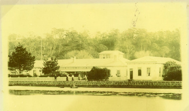
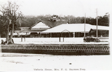 Lakes Entrance Historical Society
Photograph - Victoria House, 1920c
Mrs F G Haymes, proprietor. Photo taken prior to 1924 - memorial trees not yet plantedBlack and white tinted photograph of Victoria House, showing group of buildings, fronted by white picket fence. Wooden spoke wheeled motor vehicle in front of guest house. Bluestone wall at edge of lake, two people sitting on seat at waters edge. Lakes Entrance VictoriaVictoria House Mrs F.G Haymes Prop.guesthouses, waterfront, transport, fences -
 Lakes Entrance Historical Society
Photograph - Nithsdale, 1920 c
Nithsdale' built 1890c by Barke Brothers, early storekeepers of Lakes Entrance, occupied by William, John and Mrs Jane Barke (mother). After 1920c lived in by members of the Coate/Symmons families. Later sold to Zagami and Crea, then lived in by Richard and Marlene Rijs - late 1970's, early 1980's. Later again sold to Tromp and relocated to Lake Tyers Beach in the late 1980's or early 1990's.Black and white photograph of a late Victorian style dwelling on Esplanade. Iron hipped roof veranda on twosides, bay window in front room. Two chimneys, picket fence. Set between guest house and general store. View of lake and bluestone wall in foreground. Lakes Entrance Victoriahouses, local history, people -
 Flagstaff Hill Maritime Museum and Village
Photograph - Historical, building, Late 19th to early 20th century
The black and white photograph depicts the Lady Bay Lighthouse Complex at Flagstaff Hill, Warrnambool. It was opened on this site in 1871. From left to right, the Chartroom (previously named the Store), Upper Lighthouse, Flagstaff, Lighthouse Keeper's Quarters. The bluestone buildings are facing North on Merri Street. The Harbour Pilot's Lodgings were on the east of the Complex. There are two unknown male figures standing in front of the light-coloured picket fence that encompasses the Complex. The photograph is mounted on card. WARRNAMBOOL'S LADY BAY LIGHTHOUSES In the 1800s ships sailing from England to Australia began to use Bass Strait as a faster route to Melbourne. Small navigation errors led to many tragic shipwrecks. From 1848 lighthouses were operating along Victoria’s southern coast as a guide for sailors. Coastal towns such as Warrnambool grew and the exchange of trade and passengers was of great benefit. However, the uncertain weather changes, relatively shallow waters and treacherous, hidden rocky reefs were not really suitable for a Harbour and in the 1840s and 1850s, there were many shipwrecks in the area, with some even stranded in its Lady Bay harbour. A jetty was built in 1850 and a flagstaff to guide seafarers was placed up high on what became known now as Flagstaff Hill. In November 1857 the Victorian Government recommended that Warrnambool Harbour had beacons and two lighthouses to guide vessels into and out of the Harbour safely. The white light of the Middle Island lighthouse was to be used for the first time on September 1, 1859. The red light of the Beach Lighthouse, a wooden obelisk structure, was first operated on March 25, 1860, but in 1868 this light was ‘discontinued’ due to it being too low. Melbourne’s Department of Public Works decided to relocate the Middle Island Lighthouse Complex - Lighthouse, Keeper’s Quarters, Privy, Store Room and even water tanks - to Flagstaff Hill. The lower obelisk was shortened, and a protruding gallery, railing, and external ladder were added, and the light from the Beach Lighthouse. A green guiding light was erected on the end of the jetty. The transfer of the Complex began in March 1871. Each shaped stone of the lighthouse was carefully numbered, removed then reassembled on Flagstaff Hill. In 1872 the well was sunk behind the Lighthouse Keeper’s Cottage. The Keepers and families had left Middle Island in April and moved to Flagstaff Hill in October 1871. Vessels entering Lady Bay align the Upper and Lower Lighthouse towers during the day and the lights at night. The Upper Lighthouse is a round tower, and the Lower Light is square. The Lighthouses were categorised as harbour lights rather than coastal lights, so they remain under the control of the Victorian Government’s Ports and Harbours section. The lights were originally powered by oil, then acetylene gas, later by electricity, and then converted to solar power in 1988. In 1993 the solar panel was replaced by a battery charger. A decision was made in 1936 to replace the lighthouses’ lights with unattended lights that no longer required Keepers and Assistants. At least 29 Keepers had attended to the lighthouse from its opening in 1859 to when the last official Lightkeepers left In April 1916. The Warrnambool Harbour Board rented out the Quarters from 1916 to 1936. The Board closed down but the rentals continued with other unknown landlords. In the 1970s the Flagstaff Hill Planning Board was set up under the chairmanship of John Lindsay. The Board was to make recommendations to the Warrnambool City Council regarding using the buildings and the rest of the Crown Land on the site. The Flagstaff Hill Maritime Village opened in 1975 and began renovating the Cottage in stages, during which time evidence of a 1920s fire was found in the eastern section of the cottage. Additions of a porch on the west and a washroom on the east were made in the 1980s. The western part of the building is now a Shipwreck Museum and the east has returned to a late 19th-century Lighthouse Keeper’s cottage and includes the screen made by Assistant Lighthouse Keeper Thomas Hope in the late 19th century. He served as Assistant Keeper in Warrnambool for two periods.The Warrnambool Lighthouse Complex is now listed on the Victorian Heritage Register, H1520, for being of historical, scientific (technological) and architectural significance to the State of Victoria. The Complex is significant as an example of early colonial development. The buildings are significant for their connection with the important navigational function of the Lighthouses, a function still being performed to this day. The buildings are also significant as an example of structures designed and works carried out by the Public Works Department in Victoria in the mid-to-late 19th century. The structures still stand strong. Photograph; Warrnambool Lighthouse Keeper's cottage, lighthouse, flagstaff and chartroom at Flagstaff Hill, and a light-coloured picket fence with gate. Two male figures are in front of the fence. Black and white print glued to a yellow card. The inscription is indecipherable. The right side of the cottage has a built-in, enclosed addition.Ink stamped in lower right hand corner, too faded to be legible.flagstaff hill, flagstaff hill maritime museum, flagstaff hill maritime village, warrnambool, maritime museum, shipwreck coast, lighthouse keeper's cottage, lighthouse residence, lighthouse, chart room, quarters, privy, middle island, beach lighthouse, obelisk, lighthouse complex, lady bay complex, warrnambool port, warrnambool harbour, lady bay, keepers, lighthouse keeper, upper lighthouse, lower lighthouse, assistant keeper, ports and harbours, cottage -
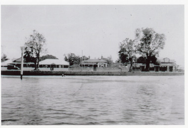
 Lakes Entrance Historical Society
Photograph - Club Hotel, 1910c
Copy is faded and stained|This is the paired before photograph used in the 150 year Lakes Entrance 1858-2008 display.|The paired after photograph number 01182.1|One other framed 12 x 16 photograph used in room display.Black and white photograph of the Club Hotel, showing a large weatherboard building, iron roof, three chimneys, partly surrounded by wooden picket fence. Large hiproofed building at right. Hotel has observation gallery included at rear of building. Bluestone wall at lake edge in front of hotel. Four people standing at front of hotel. Lakes Entrance Victoriahotels, tourism, architecture, people, room display -
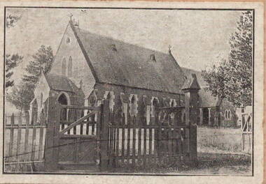 Sunbury Family History and Heritage Society Inc.
Photograph, St. Mary's Anglican Church - Sunbury
This is a photograph of St. Mary's Anglican Church in Sunbury, which is located in O'Shanassy Street in Sunbury. The congregation celebrated the official opening of their church in 1867. Services are still conducted in the church. It is one of two churches that are situated in The Village Green.St. Mary's Church of England is one of the oldest churches in the district.A scanned copy of an old black and white photograph of a simple Gothic style bluestone church with a slate roof. A wooden fence and gates are in the foreground of the building. The photograph has a cream border.st. mary's church of england., sunbury, o'shanassy street, sunbury village green -
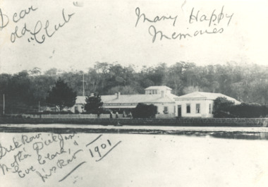 Lakes Entrance Historical Society
Photograph, Club Hotel. Lakes Entrance Victoria, 1901 c
... of building with lookout on top, picket fence in front and bluestone... fence in front and bluestone sea wall along the lake side Lakes ...Black and white photograph of Club Hotel showing full width of building with lookout on top, picket fence in front and bluestone sea wall along the lake side Lakes Entrance Victoria. Plus a second photo maybe taken earlier............hotels, accommodation