Showing 45 items
matching boat ramp
-
 Port of Echuca
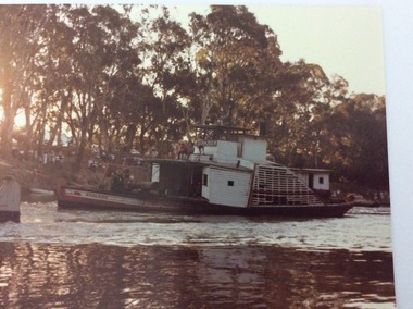
A coloured rectangular photograph, 03/04/1984
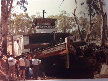
... and involved digging a boat ramp into the bank in front of the Hopwood... a boat ramp into the bank in front of the Hopwood Gardens ...Adelaide had been displayed in the Hopwood Gardens from 1960. In 1984 The City of Echuca decided to put the paddle steamer back in the river. This happened over several weeks and involved digging a boat ramp into the bank in front of the Hopwood Gardens. This involved a lot of skill and people. It also attracted a lot of attention. Crowds gathered every day to watch the task. In this photograph the P.S Pevensey in the foreground still has the name P.S Philadelphia writing on its name plate. The P.S Pevensey was used in the TV Series 'All The Rivers Run', as the P.S Philadelphia. Relates to a series of images Reg. nos. P000059.3, P000061.3, P000062.2, P000063.3, P000070.2, P000071. Statement of Significance The re-floating of the P.S Adelaide is significant because it occurred at a time when the Tourist Industry was gathering momentum in Echuca. The City of Echuca made the decision to add another paddle steamer to its fleet to carry passengers on the Murray River. The P.S Adelaide is one of the oldest, still operative wooden hulled paddle steamers in the world. It celebrated it's 150th birthday in July 2016. The re-floating of the P.S Adelaide created a lot of attention locally and regionally.A colour negative, photograph and enlargement of the re-launching of the P.S Adelaide in 1984. In the photograph the P.S Adelaide is situated in the river after just being launched down the slipway from Hopwood Gardens. There is a crowd of people standing on the bank behind the paddle steamer, bathed in late afternoon sunlight.The paddle steamer has the word Adelaide written across the wheelhouse, and on the front port side of it's hull.p.s adelaide, p.s pevensey, all the rivers run, p.s philadelphia, hopwood gardens, re-launch of the p.s adelaide -
 Warrnambool and District Historical Society Inc.
Map - An Angler's map of the Hopkins River Estuary, Angler's map Hopkins River, 1980s
... , boat ramp facilities and public access facilities. Some... the location of sand banks, the water depths, boat ramp facilities ...This is a map of the Hopkins River Estuary prepared by Dr John Sherwood for the benefit of anglers. The information on the sheet includes the location of sand banks, the water depths, boat ramp facilities and public access facilities. Some of the information has been gathered from aerial photographs. The map has been produced by the Warrnambool Institute of Advanced Education which was developed in the late 1960s from the tertiary section of the Warrnambool Technical College and with all its departments established by 1984 at the Sherwood Campus five kilometres from Warrnambool on the Princes Highway. Today the site is occupied by Deakin University, Warrnambool campus. The Warrnambool Anglers’ Club has its headquarters on the banks of the Hopkins River near the mouth of the river and the Lyndoch Aged Care facility.This map is of interest as a specialist one, providing fishermen with detailed information on all aspects of the Hopkins river estuary. Fishing has been both a profession and a popular recreational pursuit for Warrnambool residents since the early days of the city’s settlement. The Hopkins River Estuary has been a focal point for fishermen throughout Warrnambool’s history. This is a sheet of paper folded three times to produce a folded map. The front cover has a black and white photograph of two fishermen with a large fish. The map of the Hopkins River Estuary is in yellow, blue and black and covers the side of one sheet and three quarters of the other side. There is an advertisement for the Hopkins River Boathouse with a black and white sketch of the boathouse and notes on the map written by Dr John Sherwood. There are several diagrams showing the water depths. The map has some silverfish damage and some tearing at the folds. warrnambool anglers’ club, history of warrnambool, hopkins river, hopkins river estuary, john sherwood -
 Eltham District Historical Society Inc
Photograph - Digital Photograph, Marguerite Marshall, 'Worlingworth', 10-26 Banoon Road, Eltham, 30 January 2006
... and a boat-ramp.4 For most of his career Thomson, who was born... and a boat-ramp.4 For most of his career Thomson, who was born ...'Worlingworth', Eltham, home of noted anthropologist the late Professor Donald Thomson and his wife Dorita Thomson. Covered under Heritage Overlay, Nillumbik Planning Scheme. Published: Nillumbik Now and Then / Marguerite Marshall 2008; photographs Alan King with Marguerite Marshall.; p127 Dubbed as ‘Australia’s Lawrence of Arabia’ anthropologist Donald Thomson lived much of his life in Eltham, at Banoon Road. On his retirement as Professor of Anthropology in 1968, The University of Melbourne professorial board compared Thomson to Lawrence of Arabia because of his work for Aborigines and his controversial personality. Although Thomson is now recognised for his huge contribution, during his lifetime he suffered opposition and his life has been described as ‘tragic’.1 Thomson failed to gain the recognition as a scientist that he felt he deserved and he failed to alter government policy towards Aboriginal people. But towards the end of his life in 1970, anthropologists were moving towards the type of research he had done and the movement to grant land rights to Aborigines was strengthening. Thomson is best known for his anthropological fieldwork in Cape York, Arnhem Land and Central Australia, but he is also known for his scholarly contributions to ornithology and ecology. Thomson documented every aspect of the daily and ritual life of the Aboriginal world of Cape York and Arnhem Land in the 1930s and 1940s. The huge collection in Museum Victoria includes 11,000 photographs, 7500 items of material culture, 1000 botanical and zoological specimens and 4500 pages of field-notes.2 The film Ten Canoes used Thomson’s photographs as a source. Thomson bought the Eltham property known as Worlingworth in 1934. The single-storey 60-square house standing by the Yarra River was built in 1922-23. It is one of the last in Eltham to survive with its farm setting intact. It is also one of the few substantial residences built in the Eltham Shire from the late 19th century to the early 20th century, which signalled a major change in the area towards the residential municipality it is today.3 The original section, built in the mid 1860s, of rose pink hand-made bricks and stone quarried on the property, was incorporated in the new red-brick house built in 1922. An immense oak tree by the house grew from an acorn brought by Patrick Armstrong who first bought the land in March 14, 1862. Armstrong named Worlingworth after his forbears’ village in Suffolk, England. Worlingworth saw grand days when Commander Alan A Barlee (R.N.) bought it in 1922 after winning the Calcutta Sweep. The property then included a nine-hole golf course, a tennis court, a bowling green, a boathouse and a boat-ramp.4 For most of his career Thomson, who was born in 1901, was attached to The University of Melbourne. In 1935 he represented the Commonwealth Government at Caledon Bay in east Arnhem Land to investigate and mediate for four Aborigines accused of killing five Japanese and three Europeans. In 1938 Thomson was awarded a PhD in Anthropology at Cambridge University, and during his career, he received several medals from British Societies, who perhaps appreciated his work better than their Australian counterparts. From World War Two, Thomson suffered a string of hardships, beginning with severe wounding in Dutch New Guinea (for his military service in New Guinea he was awarded an OBE) and he was invalided from service in 1944. That year he was diagnosed with diabetes. A fire in 1946 destroyed what Thomson regarded as perhaps the best record he had made of Aboriginal life – the 20,000 feet, (6096m) of film he had shot in Arnhem Land. In 1954 he and wife, Gladys, divorced. The next year he married his technical assistant, Dorita McColl. Several times during his career Thomson had major disagreements. For instance Professor P Elkin constantly opposed his work. He also opposed Thomson when he campaigned vigorously in 1947 against the establishment of a rocket range at Woomera, South Australia, because of the threat it posed Aborigines. Thomson resigned in frustration from the Victorian Aborigines Welfare Board in 1967, after serving for ten years, because he found that his advice was disregarded. His ashes were scattered over Caledon Bay from the air.This collection of almost 130 photos about places and people within the Shire of Nillumbik, an urban and rural municipality in Melbourne's north, contributes to an understanding of the history of the Shire. Published in 2008 immediately prior to the Black Saturday bushfires of February 7, 2009, it documents sites that were impacted, and in some cases destroyed by the fires. It includes photographs taken especially for the publication, creating a unique time capsule representing the Shire in the early 21st century. It remains the most recent comprehenesive publication devoted to the Shire's history connecting local residents to the past. nillumbik now and then (marshall-king) collection, banoon road, donald thomson, dorita thomson, eltham, worlingworth -
 Port of Echuca
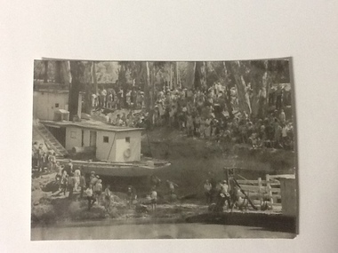
Black and white photograph, 04/03/1984
Photograph related to no.P000041, P000045 - P000048 of P. S. Adelaide re-floating. Copyright held by Riverine Herald newspaper. Original and negatives held by Riverine Herald.. Photograph taken from the river looking west towards the Echuca bank. Spectators line the higher banks and to the water line in the foreground. The back of the Adelaide and funnel is in clear view with the wheelhouse being partially obscured. The re-floating of the P. S. Adelaide was a Significant community social event evident by the number of spectators in the photograph. The community had invested a great deal of time and money into re-floating the paddlesteamer. The newspaper covered the event in detail with a number of action shots as the boat made its rear entry from the soil ramp to the water.Black and white photograph of the P. S. Adelaide on a ramp being prepared for re-floating. Spectators line the higher banks. Photograph possibly taken from the river looking west towards the Echuca bank.p. s. adelaide, echuca,victoria, re-floating of the p. s. adelaide. riverine herald newspapers, -
 Port of Echuca
Black and white photograph, 04/03/1984
Photograph related to no.P000041, P000045 - P000048 of P. S. Adelaide re-floating. Copyright held by Riverine Herald newspaper. Original and negatives held by Riverine Herald.. Photograph taken from the river looking south west as the Adelaide enters the water backwards, from the soil ramp . The right hand side of the photograph is in shadow so is very dark. 2 people can be seen on the deck with possibly another boat moored beside the Adelaide and a small motor boat to the left of that.A significant social and historical event in Echuca as many local community groups had committed many hours and much money to re-float the Adelaide to add it to the stocks for the development of the Port of Echuca as a major tourist attraction for the region.Black and white photograph of re-floating of the P. S. Adelaide in the river, possibly still partly on soil ramp. Deep shadows on the right prevent detail of front of the boat and much of the right hand bow. There are spectators in a small motorboat on left of the Adelaide and possibly another boat coming along the side of the Adelaide (2 people can be seen on the left hand side of the Adelaide). 2 people are on the deck of the Adelaide.p. s. adelaide, echuca,victoria,re-floating of the p. s. adelaide. riverine herald newspapers, -
 Port of Echuca
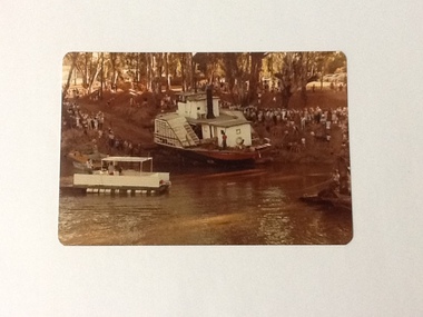
Colour Photograph, 04/03/1983
Colour photograph of P. S. Adelaide being encouraged down the soil ramp at Paddlewheel Park, onto the Murray river at Echuca. An outboard float is on the left with some spectators on it. Spectators line both sides of the ramp. Some kind of winching float is on the right. Part of photo sequence no. P000041; P000045; P000046; P000047; P000048.The re-floating of the P. S. Adelaide was a significant community social event evident by the number of spectators in the photograph. The community had invested a great deal of time and money into re-floating the paddlesteamer. The newspaper covered the event in detail with a number of action shots as the boat made its rear entry onto the Murray river.Colour photograph of P. S. Adelaide being encouraged down a soil ramp onto the river. An outboard float is on its left. Spectators line both sides of the ramp. Some kind of winching float is on the right.p. s. adelaide, echuca, re-floating p. s. adelaide -
 Port of Echuca
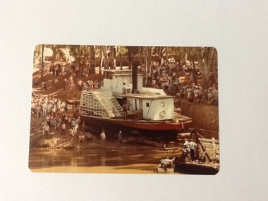
Colour Photograph, 04/03/1983
This coloured photograph shows the re-floating of the P. S. Adelaide on a soil ramp, being encouraged (rear entry) down the temporary slipway onto the river. The temporary slipway is clearly visible with a workman (possibly Kevin Hutchinson) standing at thelast log as the boat nears the waters' edge. A winching float and an outboard motor boat are at the right. Spectators line the banks of the ramp. Part of a photo sequence no.P000041; P000045; P000046; P000047; P000048 of P. S. Adelaide re-floating.The re-floating of the P. S. Adelaide was a Significant community social event evident by the number of spectators in the photograph. The community had invested a great deal of time and money into re-floating the paddlesteamer. The newspaper covered the event in detail with a number of action shots as the boat made its rear entry from the temporary slipway onto the river. Part of a photo sequence no.P000041; P000045; P000046; P000047; P000048 of P. S. Adelaide re-floating.Colour photograph of the P. S. Adelaide on a soil ramp, being encouraged (rear entry) onto the river. A winching float and an outboard motor boat are at the right front. Spectators line the banks of the ramp. Temporary slipway constructed of logs is clearly visible before the boat enters the water. -
 Port of Echuca
Colour photo and negative, 04/03/1984
This photograph shows the relaunching of the P.S Adelaide in 1984. The P.S Adelaide had sat in Hopwood Gardens since 1961 when the City of Echuca had bought the boat and returned it to Echuca. The relaunch involved digging a slipway down into the river, which this photograph shows. The paddle steamer was finally returned to the river on the 4th March 1984.This photograph is significant because it shows the P.SAdelaide being returned to the river after sitting in the Hopwood Gardens as a stationary exhibit . The P.S Adelaide is only one of two of the oldest known wooden hulled paddle steamers still operating in the world. The P.S Adelaide was the first paddle steamer bought by the City of Echuca. The P.S Adelaide celebrated her 150th birthday in 2016. This photograph relates to a series of images; P000060.3, P000061.3, P000062.2, P000063.3, P000070.2, P000071.A coloured rectangular photograph of the P.S Adelaide being relaunched from Hopwood Gardens into the Murray River. The P.SAdelaide is being towed along earth ramp with logs beneath her and spectators line the banks on each side of the paddle steamer.Written on the back in pen on P000059.3 are the words 'Belongs in Archives. Refloating Adelaide. On the boat in the photograph the name Adelaide can be seen.p.s adelaide, hopwood gardens, murray river-echuca, paddlesteamers -
 Phillip Island and District Historical Society Inc.
Newspaper clippings, 18/04/1938
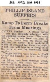
Article in Sun News Pictorial on Monday April 18th 1938.Article on a storm which caused the Cowes ferry ramp to break away from its mooring and also washed a fishing boat ashore.local history, documents, newspapers, cowes ferry ramp, phillip island, black & white newspaper clipping -
 Phillip Island and District Historical Society Inc.
Newspaper clippings, 18/04/1938
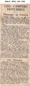
Article in The Argus newspaper on 18/04/1938Article on a severe storm at Phillip Island which washed out campers, washed fishing boats ashore and wrecked the ferry ramp.local history, documents, newspapers, storms, phillip island, black & white newspaper clipping, phillip island storm -
 Mission to Seafarers Victoria
Photograph - Photograph, Black and white, Allan Charles Quinn, Landing Docks, 30 September 1949
... sailing boats ramps promenades allan charles quinn Blue/green ink ...Allan Charles Quinn went to sea aged 16 and photographed his work and the places he visited. His collection of photo albums provides a pictorial autobiography for a period in his life. Included in the Allan Charles Quinn Collection are a series of letters written to and from his mother.Black and white photograph of landing docks at San Francisco. To the right of the photograph is the streetscape which includes a walking track and street lighting in front of a road and row of shops or houses. To the centre of the photograph are the ramps to reach the jetty where the yachts are moored. To the left of the photograph are the bows of a long line of yachts. In the background of the photograph there is a large multi-storeyed building.Blue/green ink, handwritten on reverse: "30/9/49" Handwritten in pencil: "K9/A"san francisco, sailing boats, ramps, promenades, allan charles quinn -
 Glenelg Shire Council Cultural Collection
Photograph - Photograph - Tug 'Tarragal', n.d
Port of Portland Authority ArchivesBack: Professional Photographer's Blue Stamp 69/1621 in pencil.port of portland archives, tug boat, wharf, portland -
Peterborough History Group
Peterborough Foreshore Committee Records
... in 1958. Also information about the construction of the river boat ...Records about the running of the Foreshore Reserve, including the playground and the development of the Caravan Park.Significant as it includes information about the establishment, maintenance and running of the caravan park, including a list of names of bookings in 1958. Also information about the construction of the river boat ramp and the town playground. Correspondence about a request by the Foreshore Committee to include land to the west of Peterborough but which was subsequently adopted by National Parks. It is interesting to note the names of Committee members and the changes over time. Storage box containing various documents pertaining to the running of the Foreshore Committee including cheque book, copies of correspondence, receipts and financial records.peterborough, great ocean road, camping, curdies river -
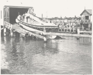 Queenscliffe Maritime Museum
Photograph - Lifeboat QUEENSCLIFFE pre-launch at its Queenscliffe ramp, The QUEENSCLIFFE preparing to be launched c1949, c1949
The Queenscliffe lifeboatPre-launch of the QUEENSCLIFFE at Queenscliffe c1949QUEENSCLIFFE lifeboat about to be launched c1949.Reverse " launching shortly after transfer from Fishermans Pier to Boat Pier / "QUEENSCLIFFE" lifeboat "lifeboat 'queenscliffe' -
 Kew Historical Society Inc
Photograph - Flooding of the Yarra River in North Kew, 1934
North Kew, now divided between Kew and Kew East, bordered the Yarra River. As such, it was a region subject to flooding in the Yarra Valley. Development beyond this point (ie Kellett Grove) was limited by the City of Kew's planning regulations. Prior to urban development, the area since European settlement and the first land sales in the district in the 1840s, had been used for dairy farming. Small sepia snapshot taken from the river ramp of a house at 8 Kellett Grove, in what was then known as North Kew. The point of view is from a backyard looking towards Fairfield. Beyond the fence line are two almost submerged houses. A number of people are in a motor driven boat midstream. Fairfield at this period, (ie 1934) was noted for its limited river side development. Verso: 2/12/34 / TAKEN FROM OUR RAMPyarra river -- north kew, floods -- yarra valley, floods -- north kew, floods -- 1929, floods -- 1934, natural disasters -- kew