Showing 62 items
matching castlemaine area
-
 Bendigo Historical Society Inc.
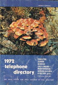
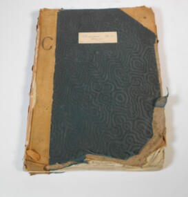
Book - BOOK - 1972 TELEPHONE DIRECTORY
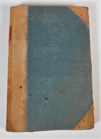
A copy of the 1972 Telephone Directy for Charlton, Echuca, Bendigo, Castlemaine, Maryborough, Kerang Districts, Kyneton area. The book is blue with a unique pattern and has a picture of the local flora.The back cover features of a map of the Bendigo Area.book, rural -
 Bendigo Historical Society Inc.
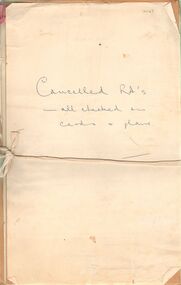
Document - LANDS OFFICE: CANCELLED R.A.'S FROM CASTLEMAINE/BENDIGO/INGLEWOOD
... PLACE Bendigo castlemaine residence areas Bendigo Sandhurst land ...Document: collection of individually tied files, tied with faded red ribbon, tied across centre with white tape. Applications for right to occupy residence areas - miners rights. On front page ' cancelled R.A's - all checked on cards and plans' written in blue ink.Lands Officeplace, bendigo, castlemaine residence areas, bendigo, sandhurst, land sales, residence areas, miners rights -
 Bendigo Historical Society Inc.
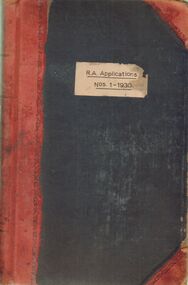
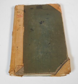
Document - LANDS OFFICE: R. A. APPLICATIONS NOS. 1 - 1930, 1936
Document: green hard cover journal with red spine and corners. On front cover ' R.A. Applications Nos. 1 - 1930' Residence areas - applicants for land Bendigo, Maldon, Castlemaine, Daylesford, Eaglehawk, Marong and district. 1936Lands Officeplace, bendigo, land sales, bendigo, sandhurst, land sales, r.a. applications -
 Bendigo Historical Society Inc.
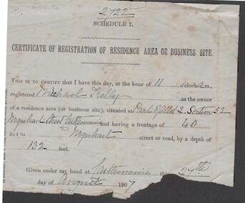
Document - KELLY AND ALLSOP COLLECTION: CERTIFICATE OF REGISTRATION OF RESIDENCE OR BUSINESS, 27/08/1907
Document. KELLY & ALLSOP COLLECTION. Certificate of Registration of Residence Area or Business Site. Issued to Michael Kelly as the owner of residence area (Part of Allot.2, Section 52) Urquhart St., Castlemaine. Frontage of 40 feet and depth of 132 feet. Dated 27 August 1907. Section at bottom is torn away where signature of issuer would be.Unknownbusiness, stockbroker, kelly & allsop, kelly & allsop collection, residence registration certificate, michael kelly, urquhart st., castlemaine -
 Bendigo Historical Society Inc.
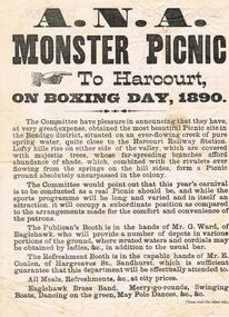
Document - A. N. A. MONSTER PICNIC 1890
Printed flyer announcing the A. N. A. Monster Picnic to Harcourt, on Boxing Day, 1890. There is a description of the picnic area, which was running the Publican's Booth and the Refreshment Booth, entertainment, and on the back the Monster Art Union 100 prizes, value £500. There is also a sports programme, details of train travel from Sandhurst, Eaglehawk, California Gully, Golden Square, Kangaroo Flat and Castlemaine. Also included are Railway Fare, Admission to Ground and a chance in the Art Union.event, social, a.n.a., a n a monster picnic 1890, harcourt railway station, mr g ward, mr e conlen, eaglehawk brass band, j e buchan -
 Bendigo Historical Society Inc.
Document - BROADCASTING STATION 3CV, MARYBOROUGH, 2 March, 1956
Broadcasting Station 3CV, Maryborough. A souvenir of the opening of the New Studios and Offices of Central Victoria Broadcasters Pty Ltd. March 2nd, 1956. Established 1956, offices in Burke Street, opening coincides with the stations 21st birthday, March 2 for the former celebration, October 26 for the latter. Coverage included Bendigo, Ballarat, Daylesford, Castlemaine and Maryborough. 3CV plays active part in assisting charities and hospitals at Maryborough, Daylesford, Maldon and Dunolly. Active Women's Radio Club with branches in country centres adds strength to station's charitable efforts. Opening 3CV's new premises will widen the scope of the station's charitable efforts, and stronger link with Australian Commercial Broadcasting stations. Writer Harold V Nunn writes history of district of Mayborough. Manager Ken J Parker, Central Victoria Broadcasters Pty. Ltd. The Souvenir brochure also covers topics such as: deep lead mining. WWI. Houses being pulled down. New settlements of Mildura. Secondary Industries. Bowenvale, Alma, Majorca, Craigie, Amherst, Adelaide Lead, Havelock, Bet Bet, Bently. Primary production and a railway staff of approximately 150. Maryborough a little town without a future. Coal fields at Wonthaggi. 1917 a public meeting was convened in an effort to stem the tide of adversity. Mayor George Frost, M.L.A., decision to form a Progress Association, a policy of secondary industry was decided upon and committees were appointed, James L Drew much credit is due. Maryborough's move for rejuvenation was revolutionary, because apart from Ballarat, Bendigo and Geelong, it was regarded as so much presumption that industry could be expected to function with success in a country town. Governments were unsympathetic. Maryborough & district people showed determination to succeed and their faith in their town. Employment and economic security provided by the industries outweighed the debt. Maryborough's general position is that it is no longer dependent upon one particular phase of activity. The first of the industries to be formed in 1918 was the Butter Factory. The nearer dairy companies did not take kindly to the prospect of another opposition company taking supplies from their districts, and in the first few years of establishment completion made the going hard for the management. But adopting a conservative policy and placing all profits to reserve I the first six years of operation headway was gradually made. Thus it was a red letter day for the company in 1925 when the first dividend of 5 percent was paid.1955 dividend of 10 per cent. Operating it's own trucks the dairy serviced local dairymen up to 40 miles. Maryborough Knitting mills est. 1923, having transferred from Clunes. Out bid Ballarat and Bendigo to the industry. The mill has what is probably the largest circular underwear plant in the Commonwealth, which is conservatively valued at 198,913 pounds. It produces between four and five million garments each year, worth over one million pounds. The company has established subsidiary mills at Dunolly, Talbot and Avoca. The company also assisted in the establishment of the Interknit Hosiery Co. Ltd., Clunes. The Maryborough Flour Mills is the second oldest of Mayborough's industries. It was built by Mr Cadwallader over 70 years ago. It was later sold to Mr. A Land and then to Jas. Minifie & Co. It had a somewhat 'in-and -out' existence until purchased in 1923 by Messrs. Willersdorf and Forbes, of Eddington. In 1939 the firm began to build silos for the storage of bulk wheat and the present storage capacity is 100,000 bushels. 1944 power was changed from steam to electricity. The mill has an out put of 20 sacks an hour. 1938 a chaff mill was built, and now is regarded as one of the best in Victoria. Its output in one year of approximately 6,800 tons is a State record for a single cutter. During this 30 year period Patience and Nicholson Limited has grown with Maryborough and is now one of the major key industries of Australia. The P&N brand covers precision tools - taps, dies and twist drills - indispensable to the country's economy, and quality is acknowledged equally by an air craft factory in Canada, a dockyard in Thailand, a railway workshop in New Zealand, no less than by our own Australian industries. Maryborough can be proud of the part played by P&N in war when, geared to the needs of the times, it poured countless millions of tools into defence factories and to the armed forces of the Allies, and now in peace when it is providing, hydro-electric undertakings and the manufacture of cars and tractors. From 1858, W Phelan & Sons Pty Ltd has made phenomenal and spectacular growth, becoming incorporated as a private company in 1929. It is without doubt the greatest private development in the history of Maryborough. 1940 joinery manufacture was commenced. The company entered the Ready Built Housing field in `950 - and in 1951 established a factory at Cairns, Northern Queensland to overcome the manufacturing difficulties being experienced due to the shortage of plywood in Victoria. Present activities include: Ready Built Housing Factory, on-site building, a modern joinery, timber yard, drying kilns, etc., and plumbing & electrical & engineering services, a door and panel factory at Cairns, retail hardware store, Melbourne Sales Depot. Hedges & Bell Pty Ltd were est 1945, with a staff of 40 employees are the largest printing firm outside the metropolitan area. The branch of Premier Wireworks is a contribution made by the decentralisation policy of the State.event, official, celebration, broadcasting station 3cv, maryborough. a souvenir of the opening of the new studios and offices of central victoria broadcasters pty ltd. march 2nd, 1956. established 1956, offices in burke street, 21st birthday. coverage bendigo, ballarat, daylesford, castlemaine maryborough. assisting charities and hospitals maldon and dunolly. women's radio club opening 3cv's new premises australian commercial broadcasting stations. writer harold v nunn writes history of district of mayborough. manager ken j parker, central victoria broadcasters pty. ltd. souvenir brochure: deep lead mining. wwi. houses pulled down. new settlements. primary production railway staff. coal fields wonthaggi. 1917 a public meeting was convened in an effort to stem the tide of adversity. mayor george frost, m.l.a., form a progress association, policy of secondary industry, james l drew rejuvenation was revolutionary, employment and economic security. the first of the industries to be formed in 1918 was the butter factory. thus it was a red letter day for the company in 1925 when the first dividend of 5 percent was paid.1955 dividend of 10 per cent. operating it's own trucks serviced local dairymen. maryborough knitting mills est. 1923 largest circular underwear plant in the commonwealth. established subsidiary mills at dunolly, talbot, avoca. interknit hosiery co. ltd., clunes. the maryborough flour mills it was built by mr cadwallader. mr. a land jas. minifie & co. messrs. willersdorf and forbes, build silos for wheat storage capacity is 100, 000 bushels. 1944 power was changed from steam to electricity. 20 sacks an hour. 1938 a chaff mill was built, best in victoria. patience and nicholson limited the p&n precision tools - taps, dies and twist drills. war, geared to the needs of the times, countless millions of tools into defence factories the armed forces of the allies, hydro-electric undertakings and the manufacture of cars and tractors. from 1858, w phelan & sons pty ltd, incorporated 1929. 1940 joinery manufacture. ready built housing field in 1950 - 1951 established a factory at cairns, northern queensland to overcome the manufacturing difficulties being experienced due to the shortage of plywood in victoria. present activities: ready built housing factory, on-site building, a modern joinery, timber yard, drying kilns, etc., and plumbing & electrical & engineering services, a door and panel factory at cairns, retail hardware store, melbourne sales depot. hedges & bell pty ltd were est. 1945, with a staff of 40 employees are the largest printing firm outside the metropolitan area. the branch of premier wireworks is a contribution made by the decentralisation policy of the state. -
 Bendigo Historical Society Inc.
Slide - MALDON & SURROUNDING AREAS, Apr 1968
Slide. Maldon & Surrounding Areas. An old house on the Muckleford to Castlemaine Road.slide, maldon & surrounding areas., maldon & surrounding areas. -
 Bendigo Historical Society Inc.
Document - STATISTICS RE GOLD ESCORTS SA & VICTORIA 1851 TO1856
Statistics re Gold Escorts (SA & Victoria re 1851-1856); author L J Blake, RHSV, no date. Statistics re South Australia (Mt Alexander to Adelaide 1852/53); Victoria (Ballarat to Melbourne, Geelong 1852; Victoria (Mt Alexander to Melbourne 1852? Escort Loadings Sample, Castlemaine 1853; Escort Loadings, all areas 1860; Total Escort Loadings, Victoria 1851 -1862.document, gold, gold escort statistics, gold escorts. south australia. victoria. -
 Stawell Historical Society Inc
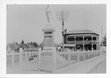
Photograph, Soldiers’ Memorial World War 1 in Main Street in front of the Coffee Palace
Soldiers’ WW1 Memorial with gate and fence around the memorial. The Weighbridge and Coffee Palace formerly Castlemaine Hotel can be seen in background. The photograph probably taken in the 1930's. Many changes have taken place since. The Coffee Palace, and Weighbridge have been removed and the area around the memorial has changed. Sepia photograph of the WW1 Soldiers Memorial with gate and fence around the memorial. Weighbridge and Coffee Place in the background. c.1930.stawell ww1 -
 Stawell Historical Society Inc
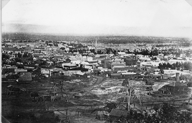
Photograph, Panorama of Stawell from Big Hill with Whims & Poppet Heads Victorian Views Collection C Herbert c.1880s
Views from Big Hill Sloane Street Fisher Street areas looking towards West. Mining in foreground of photo. Upper Main Street and Patrick Street Streetscapes visible. Mathers and Franklin. Agnew Draper. J R Franklin? Draper. Coffee Palace formerly Castlemaine Hotel , Town Hall visiblePanorama of Stawell from Big Hill showing Sloane's St. / Fisher St. areas. The photo has Whims & Poppet Heads in the foreground. There are around 6 copes of the photograph. Victorian Views. C. Herbert. Photo. Copyright Registered. Stawellstawell, panorama, mining, streetscape -
 Ballarat Heritage Services
Photograph - Image, Guildford, Victoria, 1867
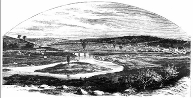
Black and white image of Guildford, near Castlemaine, VictoriaGUILDFORD Is a small township situated at the junction of Campbell's Creek and the Loddon. It is about seven miles from Castlemaine, on the road from that town to Ballaarat and Daylesford. The land near the Loddon is very rich, and as a large number both of theoretical and practical miners believe that a rich goldfield underlies the surface basalt, there is every probability of Guildford being ere an important goldfield. A large area of land in the neighbourhood has been already worked, principaIy by Chinamen, who until very recently mustered in great force in the locality. (Illustrated Adelaide Post, 23 March 1867)guildford, loddon river -
 Bendigo Historical Society Inc.
Photograph - CASTLEMAINE GAS COMPANY COLLECTION: CABLING CHAPEL AND HOPETOUN STREET
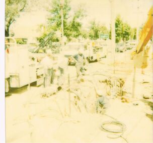
... photo digging for cabling in the area. Photograph CASTLEMAINE ...13/12/1989 - 704 5028 - Chapel and Hopetoun Street. Faded photo digging for cabling in the area.Polaroid -
 Bendigo Historical Society Inc.
Administrative record - Land Sales Register
Large cloth bound ledger, hard board cover, front and back. Over a hundred pages not all numbered. Handwritten. Dates from 1906 - 1922. ledger filled with names, addresses, financial details, and glued in posters of land sales associated with clients. Castlemaine is listed as the area for the ledger and also St Anaud, Maryborough, Avoca, Inglewood, Dunolly, Daylesford, Maldon, Heathcote, Woodend. Scratched on the front cover is a faded reading of 'Castlemaine.' Written onto the spine is written in blue texta, 'Land Sales, C'Maine,' and also '8.6.1906 to 23.2.1922.' land sales, register, castlemaine -
 Bendigo Historical Society Inc.
Administrative record - Land Sales Register - Castlemaine sec. 12
Book has a blue cover and brown leather spine. The book is a register of land sales. The sales are recorded in alphabetical order. The records give the number of the application, the date of registry, the date of application, the surname of the purchaser, the Christian name and address, the parish, allotment, section and area, the decision, special condition, the license and remarks. The book covers the years from 1896 to the 1940's. On the cover a white sticker with the words: "Castlemaine Sec 12 register" and in texter the number 26 and letter C. On the spine "S 12 171"land sales, castlemaine -
 Bendigo Historical Society Inc.
Administrative record - Land sales applications
Green cover book with brown leather spine. The book lists the applications for allotments of land for sale. The headings in the book are: number of application, date of registry, date of application, surname, Christian name and address, parish, allotment, section, area, local land board, Licence dated, licence issued, references and remarks. The book covers the years 1908-1960.On the cover in black ink "Castlemaine" and in red ink "138 front, 130 Rear" On the first page in pen: 138-129 front 130-121 back.land sales, castlemaine -
 Bendigo Historical Society Inc.
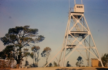
Slide - Peter Ellis Collection, Kaweka Wildflower Reserve, Castlemaine, Lightning Hill Lookout Bendigo, One Tree Hill Lookout Tower Bendigo, Kamarooka Forest Area, c1970-1972
Kaweka Reserve is a a small reserve of approximately 8ha. The land was donated to the Castlemaine City to be a wildflower Reserve. A management committee was formed in 1966. The committee is still managing the park. Vicroads Edition 6: Map 59E2, 628 H4 Location. Turner St, Castlemaine. From the Castlemaine Post Office, drive north (towards Bendigo) and turn right along Turner Street to the park entrance. What to do: walk along some of the tracks through the park follow the nature trail bird watch have a picnic at the picnic tables. RUSH Dam is a basic free camping area sits alongside Rush Dam in the Greater Bendigo National Park, featuring a single picnic table and wood fire barbecue.Peter Ellis Collection: Seventeen slides of Kaweka Wildflower Reserve, Castlemaine, Lightning Hill Lookout Bendigo, One Tree Hill Lookout Tower Bendigo. Also the Rush Dam free camping area at Kamarooka. Also a slide of an unknown group having a meal or day out; perhaps also a working bee. In addition there are two slides of a house - location not specified; and a working bee clearing along a pipeline at Big Hill. Peter was a chemistry lecturer at the Bendigo Institute of technology.history, bendigo, peter ellis collection, whipstick bendigo, bendigo state forests, kaweka wildflower reserve castlemaine, one tree hill lookout bendigo, lightning hill lookout bendigo, kamarooka, rush dam kamarooka, greater bendigo national park -
 Bendigo Historical Society Inc.
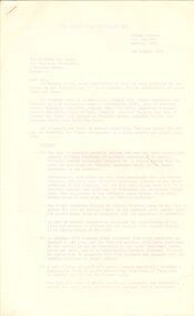
Document - PETER ELLIS COLLECTION: LETTER, 4th October, 1976
Letter, dated 4/10/1976 from Diana R. Collier, Hon. Secretary, The Bendigo Field Naturalists Club to The Minister for Lands, The Hon. W. A. Borthwick making an application to have a reserved area for the preservation of native flora and fauna near the Quarry Hill Golf Club. Features, fauna and flora are mentioned including an original Boundary Stone and the Fairy Waxflower (Eriostemon verrucosus) also known as the Bendigo Wax Flower. Included is a list of birds (including some that nest in the area sometimes) and plants.communication, postal, letters, peter ellis collection, the bendigo field naturalists club, proposed boyd st nature reserve, the hon w a borthwick, recreation reserve extension (rs 3458), cemetry reserve extension (rs 3777), rubbish depot (rs 5980), education purposes reserve, (rs 6402), j willis, bendigo city council, city boundary stone, regel, quarry hill golf club, canberra botanical gardens, stony ridge flora reserve sydney, kings park perth, maranoa gardens melbourne, kaweka sanctuary castlemaine, central and northern branch of the national trust, school sanctuary (quarry hill), education dept, society for growing australian plants - bendigo group, lawn cemetery, bendigo city council parks and recreation dept, bendigo trust afforestation committee, quality of life action group, ackhurst plan, winifred waddell estate, dept of crown lands and survey, ministry for conservation, mr g edwards, mr m goode, mr j chellacombe, diana r collier -
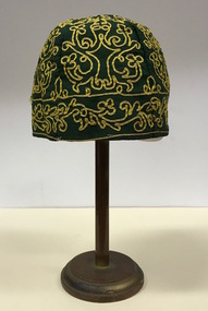 Kew Historical Society Inc
Headwear - Green Cotton & Yellow Silk Ribbon Smoker's or Lounge Cap, 1860s
The context in which the hat was made and worn assists in establishing its potential historic significance. 'Bailliere's Victorian Gazetteer and Road Guide containing the most recent and accurate information as to every place in the Colony' (1870), describes the village of Vaughan as being located on the road from Daylesford to Castlemaine. In 1870 the Vaughan was deemed to be entirely a gold mining area, gold having been discovered in the district in 1853. Intriguingly the entry in the Gazetteer claims that the electoral division of Vaughan began at the junction of the Middleton Creek and the Loddon River, so perhaps the cap might have belonged to a member of a significant local family. In 1870, Vaughan had a population of about 1000 persons and included almost 300 dwellings. Articles from newspapers, published on Trove refer frequently to a Mr Middleton as a litigant in court cases before the Vaughan Court in the 1860s. By the 1870s, the Mt Alexander Mail, in an article on ‘Mining: The Pioneer Wheel’ describes the success of Mr Middleton and his Middleton’s Reef Gold Quartz Mining Company, which had built the largest water wheel in the Colony. The wheel was 20’ in diameter and 2’ wide. Quartz mining as practiced by companies such as Middleton’s had become necessary after the exhaustion of alluvial quartz mining deposits in the 1860s. So we can probably establish a link between the cap and a significant mining identity in the period in which the article was made. The historical significance of the cap is only one part of the story. Caps such as the Middleton example can also be items of aesthetic significance as they were typically, examples of women’s work, using published patterns in magazines such as the Ladies Home Magazine. While women might follow or adapt a published pattern, their choice of materials reflected what was available locally. The fine hand stitching on this example is evidence of high quality domestic needlework. The maker crafted the cap from five triangular pieces of cotton cloth, each piece lined with a faded yellow net. The net provides some stiffening for the cap and has a functional purpose in that it anchors the hand-stitched, looped design of yellow silk ribbon that decorates the surface of the cap. Gentleman’s smoking (lounging) cap believed to have been made in c.1860-69. The conical hat is made of a dark green cotton fabric embroidered with narrow ribbon of a paler green silk. The unlined rimless hat is made of four pieces of fabric. There is no evidence of the hat at one stage featuring a tassle. The original donation record noted that the cap had been made for, and was worn by, a Mr Middleton, of Vaughan in Central Victoria. Nilhats, smokers hats, men's clothing -
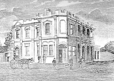 Surrey Hills Historical Society Collection
Photograph, Humberstone's Royal Hotel Surrey Hills
Humberstone's Royal Hotel was a substantial 2-storey building on the corner of Canterbury and Broughton Road. The hotel was built in 1887 to replace an older hotel (Delany's Hotel) built further east in 1856. It was de-licensed in 1921 after a "Local Option Poll" and became Tower House Day & Boarding School under Miss Marion Beetson from 1922 until 1932. It was demolished in 1932. There were 25 students in the 1920's, mostly boarders from outside Surrey Hills and all primary school students. The school room was detached from the main building and there was 6 acres of playing area. The old bar was the business office, the girls' dormitory the old dining room. Marion Beetson was the teacher, Mary Beetson managed the household. Their father was an Indian Army officer. The younger children wore a school blazer with the T.H.C. badge on the pocket. Miss Susan Kelsall visited to give piano lessons and Prof. Kelsall taught French. Miss Marion Beetson died in Castlemaine on 8 February 1952. Information courtesy of Mrs Louise Bell, Castlemaine, ex-student. See SHP0867a and SHP0867b, photos of Louisa in T.H.C. uniform. Photograph of line sketch of Humberstone's Royal Hotel, Surrey Hills. In the foreground is a horse and cart with 5 men standing in front of the hotel. Main entrance is on the corner of the intersection with large windows. There are 8 on one side and 3 on the other with 4 arches on both upper and ground floors. Turret style edging hides the rooftop with two chimneys visible. Pencilled on back "Spare - have in/ our photo files"delany's hotel, miss marion beetson, humberstone's royalhotel, surrey hills, canterbury road, broughton road, hotels, accommodation, royal hotel, tower house day and boarding school, 1880-1890, mary beetson -
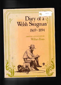 The Celtic Club
Book, William Evans, Diary of a Welsh Swagman1869-1894, 1975
... in 1869, and worked in the Ballarat and Castlemaine area. Ill, p ...The diaries of Joseph Jenkins, who migrated to Australia in 1869, and worked in the Ballarat and Castlemaine area.Ill, p. 217.non-fictionThe diaries of Joseph Jenkins, who migrated to Australia in 1869, and worked in the Ballarat and Castlemaine area. tramps - australia, australia - rural conditions -
 Wodonga & District Historical Society Inc
Book - The Mortlock Family History 1833-2003, R. Polkinghorne & R Mortlock
... settled in the Castlemaine area, Wagga Wagga and Bethanga near ...A detailed history of the Mortlock family, from their convict and then successful settler ancestor, Thomas John Mortlock, through succeeding generations of high-country settlers. Later branches of the family settled in the Castlemaine area, Wagga Wagga and Bethanga near Wodonga, Victoria. The history is profusely illustrated with maps, family photographs provided by Maud Cadman. There is some detail of the methods of settling the high country of the Monaro before the new Land Acts of 1861 and anecdotal reference to one family member running the Post Office at the Prisoner of War Camp at Cowra during World War IInon-fictionA detailed history of the Mortlock family, from their convict and then successful settler ancestor, Thomas John Mortlock, through succeeding generations of high-country settlers. Later branches of the family settled in the Castlemaine area, Wagga Wagga and Bethanga near Wodonga, Victoria. The history is profusely illustrated with maps, family photographs provided by Maud Cadman. There is some detail of the methods of settling the high country of the Monaro before the new Land Acts of 1861 and anecdotal reference to one family member running the Post Office at the Prisoner of War Camp at Cowra during World War IImortlock family, high country, bethanga, thomas mortlock, monaro -
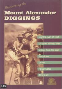 Bendigo Historical Society Inc.
Book - BOOK: DISCOVERING THE MOUNT ALEXANDER DIGGINGS - MOUNT ALEXANDER DIGGINGS COMMITTEE, 1999
... , suggested tours, drives and walks. The areas covered include Chewton.... The areas covered include Chewton, Castlemaine, Campbells Creek ...BHS CollectionSoftcover book with purple cover and a detail from a sepia photograph of miners in Forest Creek in 1858. The book is a guide to the Mount Alexander goldfields with historical notes, sites to visit, suggested tours, drives and walks. The areas covered include Chewton, Castlemaine, Campbells Creek, Vaughan, Fryerstown Newstead and Maldon. Indigenous stories are also included.Mount Alexander Diggins Committeegoldfields, gold mining, mount alexander, castlemaine, campbells creek, maldon, indigenous stories -
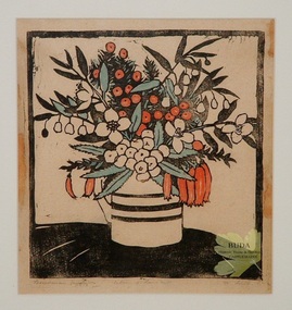 Buda Historic Home & Garden Castlemaine
Print - Linocut print, Tasmanian Berries, c 1928
Owned by the Leviny family. Collected by Kate Leviny. The Leviny women at Buda in Castlemaine were keen collectors of artworks by women printmakers from the early twentieth century.This original print by Australian woman artist, Mildred Lovett, is from a period in Australia's history when women artists and printmakers were gaining recognition for their work that had been a previously been an area dominated by male artists.Hand coloured linocut of a jug full of assorted berries, mounted in a frame. By Tasmanian artist, Mildred Lovett. Paper, ink, paint.Lower left corner 'Tasmanian berries'. Lower centre 'coloured linocut'. Lower right 'M. Lovett'. Verso '44' encircledmildred lovett, tasmania, linocut print, tasmanian berries, australian women printmakers, leviny collection, buda, castlemaine -
 Bendigo Historical Society Inc.
Administrative record - LANDS OFFICE: LAND BOARD SCHEDULE 1936 - 1949, 1936 - 1949
Ledger. Hard cover journal, orange-tan cover with leather spine and corners. Contains unused index in front of book. 740 pages with details of local land board dealings, including 'show cause'. On each page: schedule of applications and other matters considered by local land board at (name of area inserted). Some areas listed: Boort, Bendigo, Sea Lake, Robinvale, Swan Hill, Kerang, Kyabram, Castlemaine, Echuca, Daylesford, Manangatang.Lands Officeplace, land board schedules, bendigo, sandhurst, land sales -
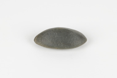 The Beechworth Burke Museum
Geological specimen - Ventifact (wind- or ice-shaped) pebble
Ventifacts are sand-blasted rocks that are typically faceted and often display parallel grooves carved by wind-blown sand. They are useful indicators of wind direction and strength in environments such as deserts, mountains, and coastal areas because they are usually not hidden by later sediment, soil or vegetation cover. In Antarctica ventifaction is strongly related to the composition or type of rock. Ventifacts are important because they provide evidence for abraders such as sand, dust or snow and ice crystals, and offer a unique understanding of past wind processes that are effective in the reconstruction of past wind flow conditions and can provides clues to weather and climate changes in the past. Interestingly ventifacts have also been found on the surface of Mars. They were a threat to the NASA rover due to the sharp angles of the facets, created by the Martian wind over the course of millions of years. These Martian ventifacts act like weathervanes for past wind and weather patterns on the red planet in a similar manner to those found on earth.The Geological Survey of Victoria was instigated in response to the Victorian Gold Rush which began around 1851 in the Beechworth, Castlemaine, Daylesford, Bendigo and Ballarat areas. The survey was conducted by Alfred Richard Cecil Selwyn from his arrival in December 1852 until his resignation in 1869and during this time he trained many notable geologists, e.g. Aplin, Wilkinson, Daintree, who went on to other State survey senior positions. This specimen was among those donated to the Burke Museum in 1868.A hand-sized solid mineral specimen in shades of dark and light browns with light lines visible in all configurations and a groove on configuration 2.light lines visible in all configurations and a groove on configuration 2burke museum, beechworth, geological, geological specimen, ventifact, antarctic region, antarctic, alfred richard cecil selwyn, alfred selwyn, wind direction, wind strength, abraders, wind flow, climate change, reconstruction of wind flow conditions, weather change, mars -
 Bendigo Historical Society Inc.
Document - LANDS OFFICE: REGISTER OF CROWN LAND LOTS SOLD BY PUBLIC AUCTION, 1951 - 1987
Document: hard cover journal, black cover with buff spine and edges. 89 pages entered with details of sales by public auction of crown lands. LH page: lot, county, town or parish, allotment, section, area, survey fee paid, upset price per lot, sold for per lot. RH page: value of improvements if any, name of purchaser, address, purchase money paid, grant fees and assurance paid.Lands Officeland sales, lands office, crown land, bendigo, kyneton, castlemaine, sea lake, girgarre, inglewood, echuca -
 Bendigo Historical Society Inc.
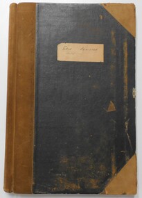
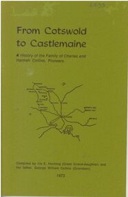
Booklet - From Cotswold to Castlemaine
A history of the Family of Charles and Hannah Collins, Pioneers. 24-page booklet. Compiled in 1973 by Iris E. Hocking (Great Granddaughter) and her father, George William Collins (Grandson). Sketch map of Victorian Goldfields area on title page. B&W photos of George C R Collins and Jemima on page 13. B&W photo of family of George and Jemima on page 14. Printed by Advertiser (Jamieson) Printery.Signature of Iris E. Hocking in ink at bottom of page 1.charles and hannah collins, family history, george c r collins, hannah charlotte whitaker-clarke, jemima martin, charles collins, hannah collins -
 Eltham District Historical Society Inc
Photograph - Digital Photograph, Alan King, Pauline Toner Butterfly Reserve, 2008
One of seven sites in Eltham and Greensborough where the butterfly survives. Published: Nillumbik Now and Then / Marguerite Marshall 2008; photographs Alan King with Marguerite Marshall.; p181 The rare Eltham Copper Butterfly, Paralucia pyro-discus, was saved from near extinction by a community campaign in the late 1980s. Thanks to that effort, the butterfly, a form of the Fiery Copper Butterfly, with a wing span of only 2.5cm, can be seen in parts of Eltham and Greensborough from late November to April. As late as 1987 the butterfly was thought to be near extinction. But that year, entomologist, Michael Braby, found several colonies, including two major ones in natural bushland on Diosma Road, Eltham. However these were threatened with destruction, as their habitat was to be destroyed by a development of 71 houses. The colonies were on a 14 hectare subdivision owned by Esanda Finance, an ANZ Bank subsidiary. It would cost around $5 million, to reimburse the bank for the land. The butterfly, which depends on woodland, a stunted form of the Sweet Bursaria bush, and the Notoncus ant, was considered too fragile to relocate. Braby’s discovery led to a sometimes fiery two-year campaign, which even became an election issue. It involved the local community, local and state governments and the developer, before a compromise was reached. The larvae have an intricate relationship with the small black ant, Notoncus. During the day, the larvae shelter in nests made by the ants around the base of the trunk and roots of the Sweet Bursaria (Bursaria spinosa). The ants are thought to protect the larvae from predators and parasites, as they attend them from the nests to feed on the Bursaria leaves at night. In return, the larvae excrete a sugar solution, which the ants love to eat. The butterfly was first recorded in Victoria in 1893, and first collected scientifically from Eltham in 1931. But it was only officially named in 1951, by Victoria’s then top butterfly expert, David Crosby.2 However, from 1970, rapid housing development in Eltham destroyed much of the butterfly’s habitat. The discovery of several major colonies in 1987 met with great excitement, and 250 people attended the first local public meeting. The State Government commissioned Crosby to investigate how to protect the butterfly, and the council froze development for three weeks. Then Esanda agreed to suspend development for several months, until a compromise was reached. Crosby recommended that 62 of the 71 lots be kept to ensure the butterflys’ survival. However this would cost $1 million to $1.5million in compensation to Esanda. Greensborough MP Pauline Toner, launched a $1million fundraising campaign and many artists donated their works to the appeal. Toner offered Clifton Pugh’s painting Eltham Copper Country to millionaire Alan Bond for $1 million, after having heard that he had offered $6 million for the Van Gough painting Sunflowers. However Bond did not accept. The butterfly was considered a ‘hot’ election issue during the by-election, following Pauline Toner’s resignation. Liberal party candidate, Margaret Brown, was accused of falsely saying she had been involved in the butterfly campaign so as to win votes. Sadly, the $1million appeal fell short at $426,000, so a compromise was reached. The State Government donated the Education Department site on Eucalyptus Road, but only nine lots of the Diosma site were bought, and the rest of the development went ahead. On March 3, 1989, Ms Toner died. Thee Eucalyptus Road site was named in her honour. Around 2000 the butterfly was further threatened by proposed developments on Pitt Street, facing the Pauline Toner Reserve and between Diosma and Nyora Roads. Fortunately the Friends of the ECB, with the Shire of Nillumbik, ensured that more habitat was made available. The butterfly now survives in seven sites in Eltham and Greensborough, including the main sites at the Pauline Toner Reserve on Eucalyptus Road, the Western and Eastern colonies on Diosma Road, and the Yandell Reserve in Greensborough.5 The butterfly survives also in Castlemaine and in the Kiata and Salisbury areas. However, it remains endangered.This collection of almost 130 photos about places and people within the Shire of Nillumbik, an urban and rural municipality in Melbourne's north, contributes to an understanding of the history of the Shire. Published in 2008 immediately prior to the Black Saturday bushfires of February 7, 2009, it documents sites that were impacted, and in some cases destroyed by the fires. It includes photographs taken especially for the publication, creating a unique time capsule representing the Shire in the early 21st century. It remains the most recent comprehenesive publication devoted to the Shire's history connecting local residents to the past. nillumbik now and then (marshall-king) collection, eltham copper butterfly, pauline toner butterfly reserve -
 Eltham District Historical Society Inc
Photograph - Digital Photograph, Alan King, Sweet Bursaria, 2008
Published: Nillumbik Now and Then / Marguerite Marshall 2008; photographs Alan King with Marguerite Marshall.; p181 The rare Eltham Copper Butterfly, Paralucia pyro-discus, was saved from near extinction by a community campaign in the late 1980s. Thanks to that effort, the butterfly, a form of the Fiery Copper Butterfly, with a wing span of only 2.5cm, can be seen in parts of Eltham and Greensborough from late November to April. As late as 1987 the butterfly was thought to be near extinction. But that year, entomologist, Michael Braby, found several colonies, including two major ones in natural bushland on Diosma Road, Eltham. However these were threatened with destruction, as their habitat was to be destroyed by a development of 71 houses. The colonies were on a 14 hectare subdivision owned by Esanda Finance, an ANZ Bank subsidiary. It would cost around $5 million, to reimburse the bank for the land. The butterfly, which depends on woodland, a stunted form of the Sweet Bursaria bush, and the Notoncus ant, was considered too fragile to relocate. Braby’s discovery led to a sometimes fiery two-year campaign, which even became an election issue. It involved the local community, local and state governments and the developer, before a compromise was reached. The larvae have an intricate relationship with the small black ant, Notoncus. During the day, the larvae shelter in nests made by the ants around the base of the trunk and roots of the Sweet Bursaria (Bursaria spinosa). The ants are thought to protect the larvae from predators and parasites, as they attend them from the nests to feed on the Bursaria leaves at night. In return, the larvae excrete a sugar solution, which the ants love to eat. The butterfly was first recorded in Victoria in 1893, and first collected scientifically from Eltham in 1931. But it was only officially named in 1951, by Victoria’s then top butterfly expert, David Crosby.2 However, from 1970, rapid housing development in Eltham destroyed much of the butterfly’s habitat. The discovery of several major colonies in 1987 met with great excitement, and 250 people attended the first local public meeting. The State Government commissioned Crosby to investigate how to protect the butterfly, and the council froze development for three weeks. Then Esanda agreed to suspend development for several months, until a compromise was reached. Crosby recommended that 62 of the 71 lots be kept to ensure the butterflys’ survival. However this would cost $1 million to $1.5million in compensation to Esanda. Greensborough MP Pauline Toner, launched a $1million fundraising campaign and many artists donated their works to the appeal. Toner offered Clifton Pugh’s painting Eltham Copper Country to millionaire Alan Bond for $1 million, after having heard that he had offered $6 million for the Van Gough painting Sunflowers. However Bond did not accept. The butterfly was considered a ‘hot’ election issue during the by-election, following Pauline Toner’s resignation. Liberal party candidate, Margaret Brown, was accused of falsely saying she had been involved in the butterfly campaign so as to win votes. Sadly, the $1million appeal fell short at $426,000, so a compromise was reached. The State Government donated the Education Department site on Eucalyptus Road, but only nine lots of the Diosma site were bought, and the rest of the development went ahead. On March 3, 1989, Ms Toner died, and the Eucalyptus Road site was named in her honour. Around 2000 the butterfly was further threatened by proposed developments on Pitt Street, facing the Pauline Toner Reserve and between Diosma and Nyora Roads. Fortunately the Friends of the ECB, with the Shire of Nillumbik, ensured that more habitat was made available. The butterfly now survives in seven sites in Eltham and Greensborough, including the main sites at the Pauline Toner Reserve on Eucalyptus Road, the Western and Eastern colonies on Diosma Road, and the Yandell Reserve in Greensborough.The butterfly survives also in Castlemaine and in the Kiata and Salisbury areas. However, it remains endangered.This collection of almost 130 photos about places and people within the Shire of Nillumbik, an urban and rural municipality in Melbourne's north, contributes to an understanding of the history of the Shire. Published in 2008 immediately prior to the Black Saturday bushfires of February 7, 2009, it documents sites that were impacted, and in some cases destroyed by the fires. It includes photographs taken especially for the publication, creating a unique time capsule representing the Shire in the early 21st century. It remains the most recent comprehenesive publication devoted to the Shire's history connecting local residents to the past. nillumbik now and then (marshall-king) collection, eltham copper butterfly, sweet bursaria -
 Bendigo Historical Society Inc.
Photograph - CASTLEMAINE GAS COMPANY COLLECTION: STORAGE AREA
BHS CollectionCollection Castlemaine Gas & Fuel. Colour photograph storage area fas stove background right, Box containing two books, number of books and paper sheets on floor, Appliance foreground right, Windows along loft side.business, retail, gas and fuel