Showing 48 items matching "city of kew -- engineers department"
-
 Kew Historical Society Inc
Plan, Melbourne & Metropolitan Board of Works : Borough of Kew : Detail Plan No.1571, 1904
The Melbourne and Metropolitan Board of Works (MMBW) plans were produced from the 1890s to the 1950s. They were crucial to the design and development of Melbourne's sewerage and drainage system. The plans, at a scale of 40 feet to 1 inch (1:480), provide a detailed historical record of Melbourne streetscapes and environmental features. Each plan covers one or two street blocks (roughly six streets), showing details of buildings, including garden layouts and ownership boundaries, and features such as laneways, drains, bridges, parks, municipal boundaries and other prominent landmarks as they existed at the time each plan was produced. (Source: State Library of Victoria)This plan forms part of a large group of MMBW plans and maps that was donated to the Society by the Mr Poulter, City Engineer of the City of Kew in 1989. Within this collection, thirty-five hand-coloured plans, backed with linen, are of statewide significance as they include annotations that provide details of construction materials used in buildings in the first decade of the 20th century as well as additional information about land ownership and usage. The copies in the Public Record Office Victoria and the State Library of Victoria are monochrome versions which do not denote building materials so that the maps in this collection are invaluable and unique tools for researchers and heritage consultants. A number of the plans are not held in the collection of the State Library of Victoria so they have the additional attribute of rarity.Digital copy of the original survey plan, issued by the MMBW to a contractor with responsibility for constructing sewers in the area identified on the plan within the Borough of Kew. The plan was at some stage hand-coloured, possibly by the contractor, but more likely by officers working in the Engineering Department of the Borough and later Town, then City of Kew. The hand-coloured sections of buildings on the plan were used to denote masonry or brick constructions (pink), weatherboard constructions (yellow), and public buildings (grey). This plan is part of a large and historically significant group of MMBW plans and maps that was donated to the Society by the Mr Poulter, City Engineer of the City of Kew in 1989. When the contracts were let for surveyors to identify and record the extant houses and landscapes within an area for the Board of Works, the contracts were let at separate times, hence the anomaly where two copies of Plan No.1571 exist in our collection. The first of these plans identifies the building materials used in houses bordering Fitzwilliam Street, Edgevale Road, May Street, Malin Street, Davis Street and Wellington Street. The cut off point for the survey was the south side of Wellington Street. By 1903 when the survey was undertaken many of the sites were already built on, particularly those facing Edgevale Road. The plan identifies the preponderance of weatherboard houses in the area. The other version of the plan identifies the buildings between Wellington Street and Cotham Road.melbourne and metropolitan board of works, detail plans, mmbw 1571, cartography -
![Workplace Humour, Engineer's Department [Kew]](/media/collectors/550653872162f11fb04854aa/items/58b818b8d0ce8a1c5052e050/item-media/58b81907d0ce8a1c5052f7dc/item-fit-380x285.jpg) Kew Historical Society Inc
Kew Historical Society IncPhotograph, City of Kew, Workplace Humour, Engineer's Department [Kew], 1961-1994
... by the City's Engineering Department preceding the amalgamation of Kew ...An original photograph donated to the Kew Historical Society by the City's Engineering Department preceding the amalgamation of Kew into the City of Boroondara. The photograph can be dated to the period 1961-1994 when the Victorian Totalisator Agency Board (TAB) began operations as a state enterprise. The latter was privatised in 1994.Public works. An ironic sign in a workplace requesting donations for a hamper. Inscription on reverse: "THE BILL DAWSON APPEAL / PLEASE GIVE (CIGARETTE BUTTS OLD TAB TICKETS) / R. GOULD (SEC) P. HUGGINS (TREASURER) / A HAMPER FOR BILL"workplace humour, city of kew -
 Kew Historical Society Inc
Photograph, Stuart Tompkins Studio, Electricity Supply Poles, South Road, Moorabbin, 1965
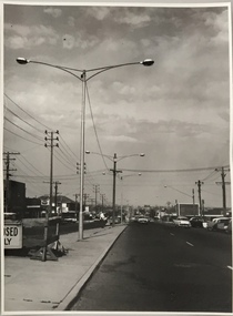
... of kew city of kew -- engineer's department Typed inscription ...Research provided by Stuart Tompkins Studio, Box Hill, into alternatives for median strip street lighting to be used in Burke Road, Kew. The photographers identified variants in different suburbs appropriate to Kew's needs.The series from which the photograph is drawn provides a snapshot by a commercial photographic studio of each named vicinity in 1965 as well as providing examples of public works infrastructure being commissioned by local government in the 1960s. The photos originally formed part of the Engineering Department's files in the City of Kew before being donated to the kew Historical Society.Electricity Supply Poles, South Road, Moorabbin, 1965. Stuart Tompkins Studio provided this photograph for the Kew City Council. The photograph of South Road, Moorabbin, west of Jasper Road, looking east depicts steel poles with two lamps in a median strip and supply wires from pole to pole. The poles were described as 100′ apart. The notation on the rear of the photograph was that there were lamps along the median strip except at intersections. A wooden pole is recognised as supporting heavy supply lines across the road. The steel poles in the photograph were said to be between 3′ to 3.5′ whereas the wooden poles were three to 12.25″ in diameter. [There are three copies of this photograph in the Collection.] Typed inscription on reverse: "Electricity Supply Poles. Photographed for Kew City Council 8/2/65. No.2 South Road - Moorabbin, west of Jasper Road, looking east. Steel poles with two lamps in median strip and supply wires from pole to pole along median strip (poles only 100' apart). Lamps along median only except at intersections. Wooden pole supports heavy supply lines across the road. Wooden poles 3' up and 8 1/2" dia. Wooden poles 3' up and 12 1/2 dia." Studio stamp: "Stuart Tompkins Studio. 547 Station Street, Box Hill. WX1439."stuart tompkins studio, street lighting, south road (moorabin) 1965, public infrastructure -- city of kew, city of kew -- engineer's department -
 Kew Historical Society Inc
Photograph, Stuart Tompkins Studio, Electricity Supply Poles, North Road, Ormond, 1965
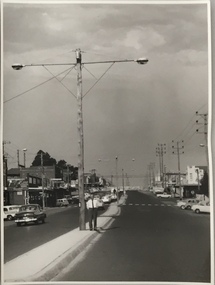
... of kew city of kew -- engineer's department Typed inscription ...Research provided by Stuart Tompkins Studio, Box Hill, into alternatives for median strip street lighting to be used in Burke Road, Kew. The photographers identified variants in different suburbs appropriate to Kew's needs.The series from which the photograph is drawn provides a snapshot by a commercial photographic studio of each named vicinity in 1965 as well as providing examples of public works infrastructure being commissioned by local government in the 1960s. The photos originally formed part of the Engineering Department's files in the City of Kew before being donated to the kew Historical Society.Electricity Supply Poles, North Road, Ormond, 1965. Electricity supply poles photographed for the Kew City Council by Stuart Tompkins Studio. The photograph of North Road, Ormond west of Jasper Road, looking east depicts wooden poles carrying two lamps in a median strip and with two on each side alternately. It was noted that the supply wires were from one side only. The poles were described as 3′ above ground and 11.25″ in diameter. The plan was to use this approach for Burke Road, Kew. [There are three copies of this photograph in the Collection.] Typed inscription on reverse: "Electricity Supply Poles. Photographed for Kew City Council 8/2/65. No.1 North Road - Ormond, west of Jasper Road, looking east. Wooden poles carrying two lamps in median strip and two on each side alternately just as is proposed for Burke Road, Kew. Supply wires from one side only. Poles 3' above ground 11 1/4" dia." Studio stamp: "Stuart Tompkins Studio. 547 Station Street, Box Hill. WX1439."stuart tompkins studio, street lighting, south road (moorabin) 1965, public infrastructure -- city of kew, city of kew -- engineer's department -
 Kew Historical Society Inc
Map, MMBW, MMBW Plan No.39 Kew & Heidelberg, 1900-1910
... assembled and originally stored in the City Engineer's Department ...The Melbourne and Metropolitan Board of Works (MMBW) was established by an act of the Victorian Parliament in 1890 to prepare for and to implement a sewerage and water reticulation system across what was then inner Melbourne, its surrounding and middle distance suburbs, including Kew. The MMBW was disbanded in 1991.The map collection of the Kew Historical Society has at its core the historic maps assembled and originally stored in the City Engineer's Department of the City of Kew. These include maps in a number of scales. The vast majority of maps were produced by the MMBW in the first two decades of the twentieth century, and are solid working maps, backed by linen for durability. These maps are historically significant to Kew, the City of Boroondara and to the history of the development of state utilities in Victoria. A number of the Kew maps have additional details added by former municipal officers, including the levels reached by various floods. As these were working documents, information was added to them long after the period of their initial production and distribution.Early map of part of the Borough of Kew, created in the first decade of the twentieth century, at a scale 160 ft to 1 inch. The map covers what was then the north western section of Kew, bordered on its north by Wills Street and the Kew Lunatic Asylum, in the west by the River Yarra [and the later added Yarra Boulevard] , by Princess Street in the East and Holroyd Street in the south. The map shows the extent of urban development by that time, prominent institutions and the outlines of built structures in the municipality. Contour lines were added in ink to the map at a later stage.MELBOURNE AND METROPOLITAN BOARD OF WORKS / PLAN NO. 39 / KEW & HEIDELBERGmelbourne & metropolitan board of works, mmbw maps, mmbw plans, borough of kew, cartography -
 Kew Historical Society Inc
Map, MMBW, MMBW Plan No.40 Collingwood & Kew, 1900-1910
... assembled and originally stored in the City Engineer's Department ...The Melbourne and Metropolitan Board of Works (MMBW) was established by an act of the Victorian Parliament in 1890 to prepare for and to implement a sewerage and water reticulation system across what was then inner Melbourne, its surrounding and middle distance suburbs, including Kew. The MMBW was disbanded in 1991.The map collection of the Kew Historical Society has at its core the historic maps assembled and originally stored in the City Engineer's Department of the City of Kew. These include maps in a number of scales. The vast majority of maps were produced by the MMBW in the first two decades of the twentieth century, and are solid working maps, backed by linen for durability. These maps are historically significant to Kew, the City of Boroondara and to the history of the development of state utilities in Victoria. A number of the Kew maps have additional details added by former municipal officers, including the levels reached by various floods. As these were working documents, information was added to them long after the period of their initial production and distribution.Early map of part of the Borough of Kew, created in the first decade of the twentieth century, at a scale 160 ft to 1 inch. The map covers what was then the south western section of Kew, bordered on its north by Studley Park Road, in the west by Walmer Street and the River Yarra, by High Street South and Princess Street in the East and Barkers Road in the south. The map shows the extent of urban development by that time, prominent institutions and the outlines of built structures in the municipality. Contour lines and historic flood levels were added in ink to the map at a later stage.MELBOURNE AND METROPOLITAN BOARD OF WORKS / PLAN NO. 40 / COLLINGWOOD & KEWmelbourne & metropolitan board of works, mmbw maps, mmbw plans, borough of kew, cartography -
 Kew Historical Society Inc
Map, MMBW, MMBW Plan No.64 Kew & Heidelberg, 1900-1910
... assembled and originally stored in the City Engineer's Department ...The Melbourne and Metropolitan Board of Works (MMBW) was established by an act of the Victorian Parliament in 1890 to prepare for and to implement a sewerage and water reticulation system across what was then inner Melbourne, its surrounding and middle distance suburbs, including Kew. The MMBW was disbanded in 1991.The map collection of the Kew Historical Society has at its core the historic maps assembled and originally stored in the City Engineer's Department of the City of Kew. These include maps in a number of scales. The vast majority of maps were produced by the MMBW in the first two decades of the twentieth century, and are solid working maps, backed by linen for durability. These maps are historically significant to Kew, the City of Boroondara and to the history of the development of state utilities in Victoria. A number of the Kew maps have additional details added by former municipal officers, including the levels reached by various floods. As these were working documents, information was added to them long after the period of their initial production and distribution.Early map of part of the Borough of Kew, created in the first decade of the twentieth century, at a scale 160 ft to 1 inch. The map covers what was then the northern most part of Kew, bordered on its north and west by the Yarra River, in the East by Connor's Creek and by the Asylum in the south. The map shows the extent of urban development by that time, prominent institutions and the outlines of built structures in the municipality. Contour lines and historic flood levels were added in ink to the map at a later stage.MELBOURNE AND METROPOLITAN BOARD OF WORKS / PLAN NO. 64 / KEW & HEIDELBERGmelbourne & metropolitan board of works, mmbw maps, mmbw plans, borough of kew, cartography -
 Kew Historical Society Inc
Map, MMBW, MMBW Plan No.65 Kew & Heidelberg, 1900-1910
... assembled and originally stored in the City Engineer's Department ...The Melbourne and Metropolitan Board of Works (MMBW) was established by an act of the Victorian Parliament in 1890 to prepare for and to implement a sewerage and water reticulation system across what was then inner Melbourne, its surrounding and middle distance suburbs, including Kew. The MMBW was disbanded in 1991.The map collection of the Kew Historical Society has at its core the historic maps assembled and originally stored in the City Engineer's Department of the City of Kew. These include maps in a number of scales. The vast majority of maps were produced by the MMBW in the first two decades of the twentieth century, and are solid working maps, backed by linen for durability. These maps are historically significant to Kew, the City of Boroondara and to the history of the development of state utilities in Victoria. A number of the Kew maps have additional details added by former municipal officers, including the levels reached by various floods. As these were working documents, information was added to them long after the period of their initial production and distribution.Early map of part of the Borough of Kew, created in the first decade of the twentieth century, at a scale 160 ft to 1 inch. The map covers what was then the south central part of Kew, bordered on its north by Malmsbury Street, in the west by Florence Avenue, in the south by Barkers Road, and in the east by Princess Street. The map shows the extent of urban development by that time, prominent institutions and the outlines of built structures in the municipality. Contour lines were added in ink to the map at a later stage.MELBOURNE AND METROPOLITAN BOARD OF WORKS / PLAN NO. 65 / KEW & HEIDELBERGmelbourne & metropolitan board of works, mmbw maps, mmbw plans, borough of kew, cartography -
 Kew Historical Society Inc
Map, MMBW, MMBW Plan No.66 Kew, 1900-1910
... assembled and originally stored in the City Engineer's Department ...The Melbourne and Metropolitan Board of Works (MMBW) was established by an act of the Victorian Parliament in 1890 to prepare for and to implement a sewerage and water reticulation system across what was then inner Melbourne, its surrounding and middle distance suburbs, including Kew. The MMBW was disbanded in 1991.The map collection of the Kew Historical Society has at its core the historic maps assembled and originally stored in the City Engineer's Department of the City of Kew. These include maps in a number of scales. The vast majority of maps were produced by the MMBW in the first two decades of the twentieth century, and are solid working maps, backed by linen for durability. These maps are historically significant to Kew, the City of Boroondara and to the history of the development of state utilities in Victoria. A number of the Kew maps have additional details added by former municipal officers, including the levels reached by various floods. As these were working documents, information was added to them long after the period of their initial production and distribution.Early map of part of the Borough of Kew, created in the first decade of the twentieth century, at a scale 160 ft to 1 inch. The map covers what was then the south eastern part of Kew, bordered on its north by Adeney Avenue, in the west by Sackville Street, in the south by Barkers Road, and in the east by Burke Road. The map shows the extent of urban development by that time, prominent institutions and the outlines of built structures in the municipality. Contour lines were added in ink to the map at a later stage.MELBOURNE AND METROPOLITAN BOARD OF WORKS / PLAN NO. 66 / KEW melbourne & metropolitan board of works, mmbw maps, mmbw plans, borough of kew, cartography -
 Kew Historical Society Inc
Map, MMBW, MMBW Plan No.67 Kew, 1900-1910
... assembled and originally stored in the City Engineer's Department ...The Melbourne and Metropolitan Board of Works (MMBW) was established by an act of the Victorian Parliament in 1890 to prepare for and to implement a sewerage and water reticulation system across what was then inner Melbourne, its surrounding and middle distance suburbs, including Kew. The MMBW was disbanded in 1991.The map collection of the Kew Historical Society has at its core the historic maps assembled and originally stored in the City Engineer's Department of the City of Kew. These include maps in a number of scales. The vast majority of maps were produced by the MMBW in the first two decades of the twentieth century, and are solid working maps, backed by linen for durability. These maps are historically significant to Kew, the City of Boroondara and to the history of the development of state utilities in Victoria. A number of the Kew maps have additional details added by former municipal officers, including the levels reached by various floods. As these were working documents, information was added to them long after the period of their initial production and distribution.Early map of part of the Borough of Kew, created in the first decade of the twentieth century, at a scale 160 ft to 1 inch. The map covers what was then the north central part of Kew, bordered on its north by the Outer Circle Railway Spruzen and Beresford Avenues, in the west by Princess Street, in the south by High Street, and in the east by (about) Belford Road. The map shows the extent of urban development by that time, prominent institutions and the outlines of built structures in the municipality. Contour lines were added in ink to the map at a later stage.MELBOURNE AND METROPOLITAN BOARD OF WORKS / PLAN NO. 67 / KEW melbourne & metropolitan board of works, mmbw maps, mmbw plans, borough of kew, cartography -
 Kew Historical Society Inc
Map, MMBW, MMBW Plan No.68 Kew, 1900-1910
... assembled and originally stored in the City Engineer's Department ...The Melbourne and Metropolitan Board of Works (MMBW) was established by an act of the Victorian Parliament in 1890 to prepare for and to implement a sewerage and water reticulation system across what was then inner Melbourne, its surrounding and middle distance suburbs, including Kew. The MMBW was disbanded in 1991.The map collection of the Kew Historical Society has at its core the historic maps assembled and originally stored in the City Engineer's Department of the City of Kew. These include maps in a number of scales. The vast majority of maps were produced by the MMBW in the first two decades of the twentieth century, and are solid working maps, backed by linen for durability. These maps are historically significant to Kew, the City of Boroondara and to the history of the development of state utilities in Victoria. A number of the Kew maps have additional details added by former municipal officers, including the levels reached by various floods. As these were working documents, information was added to them long after the period of their initial production and distribution.Early map of part of the Borough of Kew, created in the first decade of the twentieth century, at a scale 160 ft to 1 inch. The map covers what was then the north central part of Kew, bordered in the north by Oak Avenue, in the west by the Yarra River and Connor's Creek, in the south by Beresford and Carnegie Avenues, and in the east by Glass's Creek and Burke Road. The map shows the extent of urban development by that time, prominent institutions and the outlines of built structures in the municipality. Contour lines and the levels of historic floods were added in ink to the map at a later stage.MELBOURNE AND METROPOLITAN BOARD OF WORKS / PLAN NO. 68 / KEW melbourne & metropolitan board of works, mmbw maps, mmbw plans, borough of kew, cartography -
 Kew Historical Society Inc
Map, MMBW, MMBW Plan No.117 Heidelberg & Kew, 1900-1910
... assembled and originally stored in the City Engineer's Department ...The Melbourne and Metropolitan Board of Works (MMBW) was established by an act of the Victorian Parliament in 1890 to prepare for and to implement a sewerage and water reticulation system across what was then inner Melbourne, its surrounding and middle distance suburbs, including Kew. The MMBW was disbanded in 1991.The map collection of the Kew Historical Society has at its core the historic maps assembled and originally stored in the City Engineer's Department of the City of Kew. These include maps in a number of scales. The vast majority of maps were produced by the MMBW in the first two decades of the twentieth century, and are solid working maps, backed by linen for durability. These maps are historically significant to Kew, the City of Boroondara and to the history of the development of state utilities in Victoria. A number of the Kew maps have additional details added by former municipal officers, including the levels reached by various floods. As these were working documents, information was added to them long after the period of their initial production and distribution.Early map of part of the Borough of Kew, created in the early twentieth century, at a scale 160 ft to 1 inch. The map covers what was then the north eastern part of Kew showing the natural landscape and limited development on the south side of the Yarra River. In the Kew section, south of the river, the land is occupied currently by the Greenacres and Kew Golf Clubs. The map shows the extent of urban development by that time and the outlines of the few built structures in the municipality. The height above sea level of all parts of the landscape are indicated numerically in feet. Contour lines and the levels of historic floods were added in ink to the map at a later stage. MELBOURNE AND METROPOLITAN BOARD OF WORKS / PLAN NO. 117 / HEIDELBERG & KEW melbourne & metropolitan board of works, mmbw maps, borough of kew, cartography, mmbw plan no. 117, kew (vic.) -- maps, heidelberg (vic.) -- maps -
 Kew Historical Society Inc
Map, MMBW, River Yarra Beautification Schemes, c.1913
... assembled and originally stored in the City Engineer's Department ...The Melbourne and Metropolitan Board of Works (MMBW) was established by an act of the Victorian Parliament in 1890 to prepare for and to implement a sewerage and water reticulation system across what was then inner Melbourne, its surrounding and middle distance suburbs, including Kew. The MMBW was disbanded in 1991.The map collection of the Kew Historical Society has at its core the historic maps assembled and originally stored in the City Engineer's Department of the City of Kew. These include maps in a number of scales. The vast majority of maps were produced by the MMBW in the first two decades of the twentieth century, and are solid working maps, backed by linen for durability. These maps are historically significant to Kew, the City of Boroondara and to the history of the development of state utilities in Victoria. A number of the Kew maps have additional details added by former municipal officers, including the levels reached by various floods. As these were working documents, information was added to them long after the period of their initial production and distribution.Map of the City of Kew showing part of the River Yarra Beautification Schemes. The map shows development to date and the flood levels reached in 1923 and 1924. This map may have been adapted from an earlier map, as most development in central Kew and Studley Park had occurred by this date yet numerous streets are not represented. Public buildings and institutions are clearly represented and named on the map as are significant public transport infrastructure (eg the Outer Circle railway).MELBOURNE AND METROPOLITAN BOARD OF WORKS / RIVER YARRA BEAUTIFICATION SCHEMES / SCHEME / SCALE 10 CHAINS TO AN INCHmelbourne & metropolitan board of works, mmbw maps, mmbw plans, city of kew, flood levels -- kew (vic.), cartography -
 Kew Historical Society Inc
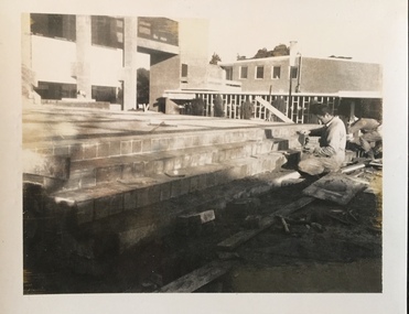
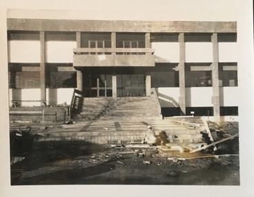
Photograph - Construction of the Kew Civic Centre, 1972
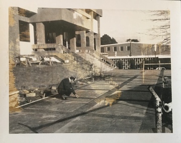
The Kew Civic Centre, as opposed to the adjacent Kew Civic Hall (see also Kew City Hall), was built to house a new Council Chamber and Council Offices in 1972. The Kew Library was to be located on the ground floor and accessed from the current carpark. This building replaced the former Town Hall in Walpole Street, Kew which had served as a town hall from 1865-1972. After the sale of the old Town Hall, the new Civic Centre was built to a design of the architects A K Lines, MacFarlane & Marshall. A fit-out of the building was still occurring when councillors and council officers moved into the building. In 1987, the Kew Library (and the Kew Historical Society) moved across the road to the reconfigured Civic Hall. The Civic Centre, pictured here, was ultimately sold to Trinity Grammar School following the amalgamation of Kew into the City of Boroondara.These four black and white photographs were taken by a photographer in the City Engineer's Department during the final construction phase. Each is dated and inscribed with a description.Laying of concrete tiles in the forecourt of the new Kew Civic Centre in 1972. The Civic Hall (now the Kew Library) is in the background. Annotated verso: "Civic Centre - Forecourt / 17.7.72"kew civic centre, kew civic offices, city of kew -- council chamber -
 Kew Historical Society Inc
Photograph - Construction of the Kew Civic Centre, 1972
The Kew Civic Centre, as opposed to the adjacent Kew Civic Hall (see also Kew City Hall), was built to house a new Council Chamber and Council Offices in 1972. The Kew Library was to be located on the ground floor and accessed from the current carpark. This building replaced the former Town Hall in Walpole Street, Kew which had served as a town hall from 1865-1972. After the sale of the old Town Hall, the new Civic Centre was built to a design of the architects A K Lines, MacFarlane & Marshall. A fit-out of the building was still occurring when councillors and council officers moved into the building. In 1987, the Kew Library (and the Kew Historical Society) moved across the road to the reconfigured Civic Hall. The Civic Centre, pictured here, was ultimately sold to Trinity Grammar School following the amalgamation of Kew into the City of Boroondara.These four black and white photographs were taken by a photographer in the City Engineer's Department during the final construction phase. Each is dated and inscribed with a description.Forecourt of the new Kew Civic Centre in 1972.Annotated verso: "Civic Centre - Forecourt / 16.7.72"kew civic centre, kew civic offices, city of kew -- council chamber -
 Kew Historical Society Inc
Photograph - Construction of the Kew Civic Centre, 1972
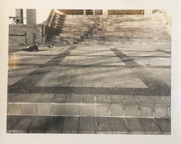
The Kew Civic Centre, as opposed to the adjacent Kew Civic Hall (see also Kew City Hall), was built to house a new Council Chamber and Council Offices in 1972. The Kew Library was to be located on the ground floor and accessed from the current carpark. This building replaced the former Town Hall in Walpole Street, Kew which had served as a town hall from 1865-1972. After the sale of the old Town Hall, the new Civic Centre was built to a design of the architects A K Lines, MacFarlane & Marshall. A fit-out of the building was still occurring when councillors and council officers moved into the building. In 1987, the Kew Library (and the Kew Historical Society) moved across the road to the reconfigured Civic Hall. The Civic Centre, pictured here, was ultimately sold to Trinity Grammar School following the amalgamation of Kew into the City of Boroondara.These four black and white photographs were taken by a photographer in the City Engineer's Department during the final construction phase. Each is dated and inscribed with a description.Tiling the steps leading from the forecourt to the new Kew Civic Centre in 1972.Annotated verso: "Civic Centre - Forecourt / 16.7.72"kew civic centre, kew civic offices, city of kew -- council chamber -
 Kew Historical Society Inc
Photograph - Construction of the Kew Civic Centre, 1972
The Kew Civic Centre, as opposed to the adjacent Kew Civic Hall (see also Kew City Hall), was built to house a new Council Chamber and Council Offices in 1972. The Kew Library was to be located on the ground floor and accessed from the current carpark. This building replaced the former Town Hall in Walpole Street, Kew which had served as a town hall from 1865-1972. After the sale of the old Town Hall, the new Civic Centre was built to a design of the architects A K Lines, MacFarlane & Marshall. A fit-out of the building was still occurring when councillors and council officers moved into the building. In 1987, the Kew Library (and the Kew Historical Society) moved across the road to the reconfigured Civic Hall. The Civic Centre, pictured here, was ultimately sold to Trinity Grammar School following the amalgamation of Kew into the City of Boroondara.These four black and white photographs were taken by a photographer in the City Engineer's Department during the final construction phase. Each is dated and inscribed with a description.Creating the forecourt to the new Kew Civic Centre in 1972.Annotated verso: "Civic Centre - Forecourt / 16.7.72"kew civic centre, kew civic offices, city of kew -- council chamber -
 Kew Historical Society Inc
Photograph - Denmark Street, Kew, 1972
... The Engineer's Department of the former City of Kew had... The Engineer's Department of the former City of Kew had an extensive ...The Engineer's Department of the former City of Kew had an extensive collection of photograph of sites in Kew requiring documentation to inform public works. It also kept images of engineering practice in other parts of Melbourne, and overseas, that could be used as models for local activity. Many of these photographs (and plans) were donated to our collection in the 1980s. A number of the photographs are annotated, either on the image itself or on the reverse.This photograph, and others sourced from the City Engineer's Department of the former City of Kew, qualifies as an important record of local streets, public works, street beautification, and engineering techniques of the period. Original black and white photographic positive of automobiles and buildings in Denmark Street, Kew, immediately before the road enters Kew Junction. On the left is McKeon Motors and a retailer of Insulwool, while in the distance is the pharmacy on the corner of High Street and Princess Street (later demolished during the widening of Kew Junction). Notable are the bluestone guttering and what appears to be vacant land on the apex of the triangle of land bounded by High Street South, Denmark Street and Barkers Road. This site was the original location of O'Shaughnessy's 'Kew Hotel', and after the destruction by fire of the latter, the location of a service station. [It is now the site of the Cresco Reserve].Annotation verso: "Indicating the existence of a vehicular entrance at Denmark St abuttal of No.188 High St prior to reconstruction of channeling &c 1972."denmark street -- kew (vic.), kew junction, luestone gutters, mckeon motors, insulwool