Showing 444 items
matching clearing
-
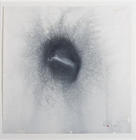 Nillumbik Shire Council
Drawing (ink): Cameron ROBBINS, 3-9-06 1.00pm KGMT / amid changes, SW / 10am 4-9 clearing / 21hours
-
 Swan Hill Regional Art Gallery
Painting, LAW, C Anthony, Clearing, 1986
-
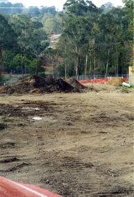 Whitehorse Historical Society Inc.
Photograph, Deep Creek Road Clearing, 1/07/2001 12:00:00 AM
Coloured Photo of Site cleared for Path of Bridge and Entrance on Deep Creek Road, Mitcham.deep creek road, mitcham. -
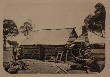 Ballarat Heritage Services
Image, A Log Hut in the Clearing, c1918, c1918
Black and white image of a slab hut.bushman, log hut, architecture -
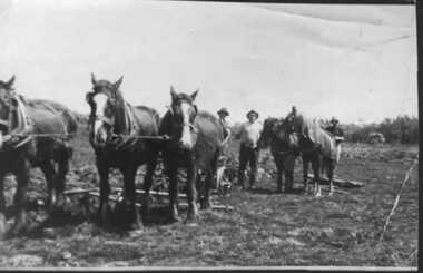 Inverloch Historical Society
000902 - Photograph - Point Smythe - c1936 - Mcdonald Farm - horse teams clearing bush - Christmas postcard to Lloyd Beard and family - from Dorothy Beard
-
 Ringwood and District Historical Society
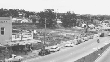
Photograph, Ringwood Coolstore site after clearing, 1962
Black and white photograph (2 copies)Image taken from Town Hall roof and shows cleared site of coolstore on corner of Maroondah Highway and Wantirna Road. -
 Ringwood and District Historical Society
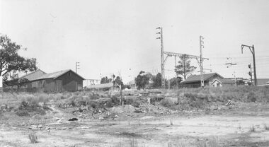
Photograph, Ringwood Coolstore site after clearing in 1963, 1963
Black and white photographWritten on back of photograph: "Site of Cool Store- 17.11.63. Old goods shed to the left, new shed to the right. Kendall's house (old hospital) in background. Corner of Whitehorse Road and Watirna Road. Photographed by Brian Pump, 36 Knaith Road, Ringwood East. -
 National Vietnam Veterans Museum (NVVM)
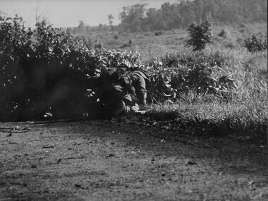
Photograph, Gibbons, Denis, Clearing Road Block
Denis Gibbons (1937 – 2011) Trained with the Australian Army, before travelling to Vietnam in January 1966, Denis stayed with the 1st Australian Task Force in Nui Dat working as a photographer. For almost five years Gibbons toured with nine Australian infantry battalions, posting compelling war images from within many combat zones before being flown out in late November 1970 after sustaining injuries. The images held within the National Vietnam Veterans Museum make up the Gibbons Collection.A black and white photograph of an Australian Engineers crawls around a road block constructed by VietCong across the National Highway North West of the Province capital Baria. Once the charges and mines were isolated, the Engineer cleared the obstruction and reopened the roadphotograph, nva/vc, engineers, baria, gibbons collection catalogue, viet cong, national highway, province, land mines, denis gibbons -
 Mt Dandenong & District Historical Society Inc.
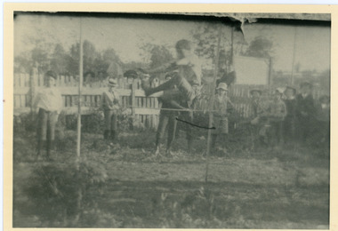
Photograph, High Jump Olinda Sports Carnival 1909
Scene from the Easter Monday Olinda Sports Carnival in 1909 with Alan Dodd clearing the high jump bar and Ernie Schneider standing to the left of the bar. The descriptive text on the reverse of this photograph was hand written by John Lundy-Clarke.1909 Alan Dodd clearing the bar. Ernie Schneider to the left of the bar.olinda, olinda school, alan dodd, ernie schneider, sports, sports carnival -
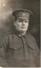 Hume City Civic Collection
Photograph, 2/11/1915
Sargent Medical Corps. 2nd Australian Casualty Clearing StationA b/w postcard portrait of soldier H. Martin.Typewritten on front: Private H. Martin Printed on front: TALMA MELBOURNE Handwritten on back: PRIVATE H.J. MARTIN, 2ND AUST CASUALTY CLEARING STATION A.M.C. (ON ACTIVE SERVICE) 2/11/15world war 1, martin, h. j. (private), soldiers, armed forces, uniforms, clothing and dress, postcards, george evans collection -
 Orbost & District Historical Society
black and white photograph, 1913
This photograph shows Country Roads Board men clearing a bush track at Hospital Creek. Their vehicle was bogged. The y Roads Board was formed in 1913 1910 it had become apparent that there was a need for a central roads authority to take over responsibility from the Board of Lands and Works for the care and management of the main roads of the state of Victoria. Because there was no consistent and systematic policy for road maintenance Victorian roads were in a deplorable condition. At this time the use of the motor car accentuated the demands for better roads. As a result of these needs the Country Roads Act 1912 was proclaimed in 1913 providing for the establishment of the Country Roads Board as a central road authority with responsibility for those roads within the State considered to be main roads. the C.R.B. was responsible for the construction of roads and bridges including the Snowy River road bridges in Orbost.. This is a pictorial record of transport difficulties in East Gippsland in early 20th century.A large black / white photograph of three men clearing a bush track with a motor vehicle behind them.transport roads road-maintenance country-roads-board -
National Vietnam Veterans Museum (NVVM)
Document, Extract from 17 Construction Sqn RAE Routine Orders: letter of thanks from the people of Tam Phuoc
The letter is from the people of Tam Phuoc expressing their thanks to the commanders & all drivers & crews of the 17th Const. Sqn Land Clearing Team & the 3rd Cav Det attached to the Land Clearing Team for clearing the land for their village.17th construction squadron, 3rd cavalry regiment, land mines -- tam phuoc -
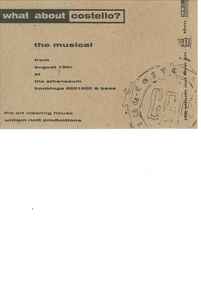 Melbourne Athenaeum Archives
Theatre Flyer, What About Costello (musical) performed at Athenaeum Theatre Two, Melbourne commencing 18 August 1994
D-XTYRIA also performed ornamental collaspe at the athenauem theatre for the 21-30 August 1994a small flyerThe art clearing house William Nott productionswilliam nott productions, art clearing house, what about costello, musical, athenaeum theatre\ -
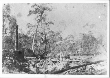 Halls Gap & Grampians Historical Society
Photograph - B/W
The photo shows the site and remains of John Child's Glenbower Mill (which operated in the mid-1800's).The photo shows a clearing with the remains of an old building and steam engine on the front left. A small hut can be seen at the back of the clearing, to the right of centretimber industries, logging, sawmilling -
 Kiewa Valley Historical Society
Photographs x 2 1. Lake Guy & Bogong Village 2. Bulldozer moving rocks
1. In 1940 Field Headquarters for the Kiewa Scheme were established at Bogong with office, workshop facilities and accommodation for workmen, staff and some families constructed. (There had been a 'tent camp' on this site in 1939 but was destroyed by bushfires) Construction of accommodation continued until 1947. A total of 40 houses plus a hostel for single staff, post office, police station, medical centre and primary school all with water and sewerage and electricity supply. The staff hostel was known as Kiewa House and is now occupied by the Education Department. Lake Guy was named after Mr. L.T. Guy who was the Resident Engineer in charge of construction work and associated activities on the Kiewa area. He held this position from 1939 to November 1946 when he was transferred to Head Office. 2. Example of the type of heavy machinery used in clearing and building of Lake Guy, Bogong Village and Clover Dam 1. The Bogong Township was developed firstly as an accommodation centre (base camp) for construction workers employed under the Kiewa Hydroelectric Scheme. At the completion of the scheme, in the 1960's, the village was opened to public/tourism use. Strict environmental control has not allowed for any extensive redevelopment in tourist accommodation and basically restricted it to the accommodation initially built for the construction workers. Lake Guy is one of the many water storage reservoirs used to supply the power stations their main power to run the huge turbines generating the final product, electricity 2. Pictorial record of the types of machinery used in the development of Bogong Village and the Hydro-electricity scheme including the Clover Dam. Note the lack of safety equipment worn by construction workers of the period. 2 black and white photographs taken at Bogong 1. Lake Guy with Bogong Village in the background 2. Workman in bulldozer clearing rocks, possibly for construction at Bogong1. Handwritten in blue ink on back of photo 'Lake Guy showing Bogong Village' 2. No markingslake guy, bogong village, secv -
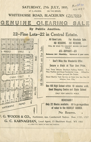 Whitehorse Historical Society Inc.
Document, Central Estate, 1935
Clearing saleClearing sale - 22 lots in Central Estate.Clearing sale g. woods & co. auctioneer, g. c. karnaghan estate agent, whitehorse road, blackburn, williams road, harold street, o'hara street -
 Running Rabbits Military Museum operated by the Upwey Belgrave RSL Sub Branch
Photo Display Gallipoli
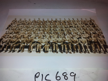
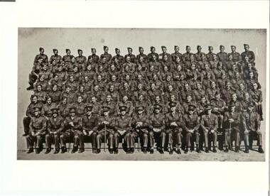
Photograph of members of 32 Casualty Clearing Stationphoto, ww2, army -
 Mt Dandenong & District Historical Society Inc.
Photograph, Site of Jeannie Richardson's Home 1973
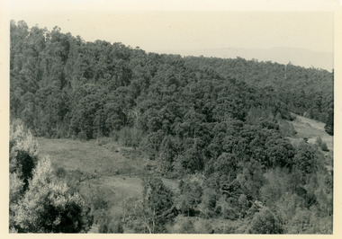
John Lundy-Clarke grew up in the Kalorama/Mt Dandenong area and later in life (1972-74) began to write a comprehensive history of the area working from an original settlement map in an effort to cover all areas. It was in the clearing on the left that John William (Willie) Richardson built a home for his wife Jeanie Green. It was called Mount Calvin. Jeanie was often ill and the family left the area seeking a warmer climate. They eventually settled in Brisbane. Willie sold the home and 60 acres around it to W. Rowse. Jeanie died in 1916. The remainder of the land was sold by solicitors to cover debts. Black and white photograph showing a treed hillside with a cleared area to the left hand side. Handwritten inscription on reverse by John Lundy-ClarkeLooking towards the site of Jeannie's home from near Doughty’s Road Nov 1973. Her house was in the centre of the clearing on the left. Photo Jan 1974 JLC.mount calvin, jeannie richardson, jeanie green, john william richardson, willie richardson, jeanie richardson, rowse -
 Marysville & District Historical Society
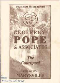
Ephemera (Item) - Property sales booklet, Geoffrey Pope, Local Real Estate Report-Geoffrey Pope & Associates, Unknown
A property sales booklet advertising properties for sale in Marysville and surrounding locations in Victoria.A property sales booklet advertising properties for sale in Marysville and surrounding locations in Victoria.re: CLEARING COLIN LAWRY (057) 747 345marysville, victoria, geoffrey pope & associates, geoffrey pope, real estate, the courtyard, real estate sales -
 Halls Gap & Grampians Historical Society
Photograph - B/W, C 1900s
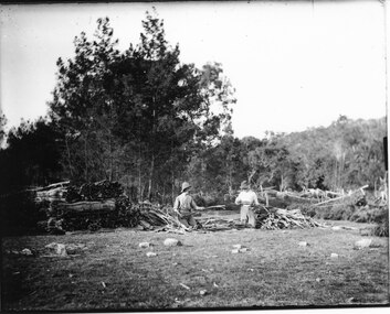
Wattle-bark stripping (bundling) at Roses Gap. The identity of the men is unknown.The photo shows two men kneeling in a clearing. They are both working on pieces of wattle bark and have piles of bark around them. There is thick bush behind the clearing.timber industries, wattlebark stripping, scenery, roses gap -
 Running Rabbits Military Museum operated by the Upwey Belgrave RSL Sub Branch
Photograph
32 Casualty Clearing Station, with most names on the rearphoto, ww2, army -
Beechworth Honey Archive
Particulars of Land
Particulars of land; Particulars of improvements in lands included in returns stated here. [ca 1910] Blue-ish coloured document with yellowing edges. Has two sections; Nature of Improvements and Values as at 30th June 1910. In section one, 6 subsections listed. 1:1; fencing, draining, clearing, 2:1; £350.0.0 1:2; building, fencing, drainage, clearing, 2:2; £397.0.0 1:3; fencing, clearing, 2:3; £387.0.0 1:4a; dwelling (2), fencing, clearing 2:4a; £352.0.0 1:5; fencing, clearing, 2:5; £18.0.0 1:4b; fencing clearing, 2:4b £25.0.0 Total £1529.0.0particulars of land, frost, beekeeper, beechworth honey -
 Running Rabbits Military Museum operated by the Upwey Belgrave RSL Sub Branch
Flag
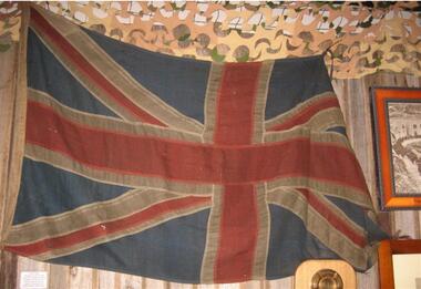
Union Flag of Great Britain, No 3 Casualty Clearing Station.flag/banner, ww1, army -
 Orbost & District Historical Society
black and white photograph, late 19th century - early 20th century
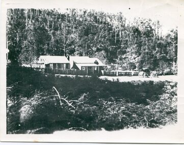
A black / white photograph of an early settler's home on a small clearing in bushland.on back - Boarding House at Sardine Creeksardine-creek -
 Phillip Island and District Historical Society Inc.
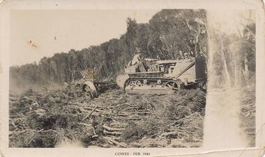
Photograph, 02/1941
One of a group of photographs from the Bryant West Collection donated by Mary Karney.Black & White photograph of a bulldozer clearing land in Cowes February 1941Cowes Feb 1941land clearing cowes phillip island, bulldozer, bryant west collection, mary karney -
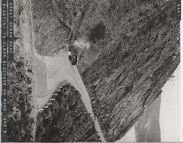 Lorne Historical Society
Photograph, Blasting to clear blockage Great Ocean Road circa 1940's
Photograph showing workmen clearing blockage on the G.O.R. circa 1940'sg.o.r; road blockage; road-blasting-1940's -
Glenelg Shire Council Cultural Collection
Mixed media - DVD - History of land clearing in the Glenelg Shire, How the West was Won, 2010
DVD. How the West was Won, history of land clearing in the Glenelg Shire -
 National Vietnam Veterans Museum (NVVM)
Document
Series of 9 pictorial/information pages explaining the Diorama of mine clearing.mine clearing -
 National Vietnam Veterans Museum (NVVM)
Document
Series of 9 pictorial/information pages re equipment used in mine clearing.mine clearing -
 National Vietnam Veterans Museum (NVVM)
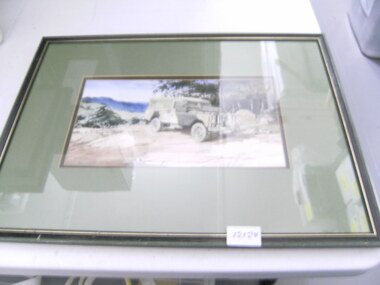
Painting, Landrover in Jungle
Framed coloured artwork by D Leversha of a camouflage painted landrover in a jungle clearing.Rego NRP 110drawing, d leversha, landrover, leversha, water colour, mutt