Showing 76 items matching "community collections - certificate"
-
 Federation University Historical Collection
Book, School of Mines and Industries, Ballarat, Submission for the Accreditation of a Community Welfare and Development Certificate, 1978
Course outline Yellow covered A4 book of 64 pagesballarat school of mines, community welfare -
 Bendigo Historical Society Inc.
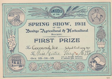
Document - GERTRUDE PERRY COLLECTION: BENDIGO AGRICULTURAL SHOW CERTIFICATE, 1931
Document. Bendigo Agricultural Show Certificate. Certificate awarded to Gertrude Perry by the Bendigo Agricultural & Horticultural Society for First Prize for Coconut Ice School Girl any Age No 792. Printed by Bolton Bros in blue on buff card.organization, club/society, community, gertrude perry collection, bendigo agricultural show certificate gertrude perry, bendigo agricultural & horticultural society, bolton bros -
 Bendigo Historical Society Inc.
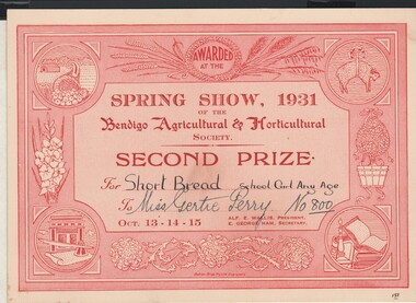
Document - GERTRUDE PERRY COLLECTION: BENDIGO AGRICULTURAL SHOW CERTIFICATE, 1931
Document. Bendigo Agricultural Show Certificate. 1931 Certificate awarded to Gertrude Perry by the Bendigo Agricultural & Horticultural Society for Second Prize for Short Bread School Girl any Age No 800. Printed by Bolton Bros. in red on buff card.organization, club/society, community, gertrude perry collection, bendigo agricultural show certificate, bendigo agricultural & horticultural society, bolton bros. -
 Bendigo Historical Society Inc.
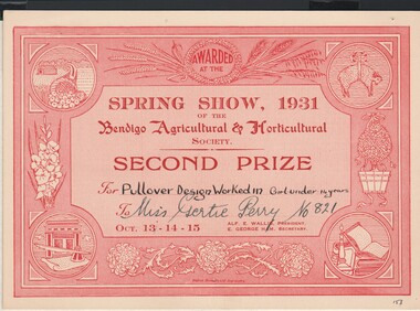
Document - GERTRUDE PERRY COLLECTION: BENDIGO AGRICULTURAL SHOW CERTIFICATE, 1931
Document. Certificate awarded to Gertrude Perry in 1931 by the Bendigo Agricultural & Horticultural Society for Second Prize for Pullover Design Worked In Girl under 14 years No821. Printed by Bolton Bros. in red on buff card.organization, club/society, community, gertrude perry collection, bendigo agricultural & horticultural society, bolton bros -
 Bendigo Historical Society Inc.
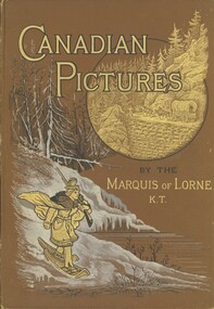
Book - PETHARD COLLECTION: CANADIAN PICTURES, 1887
Pethard collection,Hard cover book Canadian Pictures by the Marquis of Lorne K.T. A book of history & life in Canada. Brown cover with gold lettering & scenes, published by the Religious Tract Society London. Black and white illustrations drawn with pen and pencil printed by R.Clay sons and Taylor printers London. Contains fold out map in colour. Presentation certificate inside front cover reads, presented to Mr.G.A.Pethard by the members of the Mount Pleasant Glee class on his leaving Ballarat for Warragul, as a small token of esteem. Ballarat 20th May 1887. Some of the items in the Pethard Collection were donated by Barbara Bessley. The donor worked for the trustee for the Pethard Estate and to prevent the material being disposed of, she retained it. George Pethard, in his role as Mayor of Bendigo, was active in community organisations and was a member of a contingent which travelled overseas to promote Victoria. The items in this collection help to illustrate some oof Pethard's work for Bendigo and the State of Victoria.Marquis of Lorne K.T.books, albums, canada -
 Bendigo Historical Society Inc.
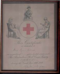
Document - LYDIA CHANCELLOR COLLECTION: AUSTRALIAN RED CROSS CERTIFICATE
An Australian Red Cross Certificate in a brown glassed frame. It was presented to Miss Lydia Pethard in 'recognition of five years service under the Australian Red Cross Society (A.R.C.S.) during the Great War 1914 1919.' C 1920 The certificate which is signed by Lady Helen Munro Ferguson, has a picture of a red cross in a circle with a seated nurse on the left who is knitting, a soldier in the centre above the circle and a nurse who is seated sewing on the right.document, certificate, australian red cross, lydia chancellor, collection, civic momentoes, plaque, war, w.w. ii., certificate, community, clubs and associations, voluntary work, document -
 Bendigo Historical Society Inc.
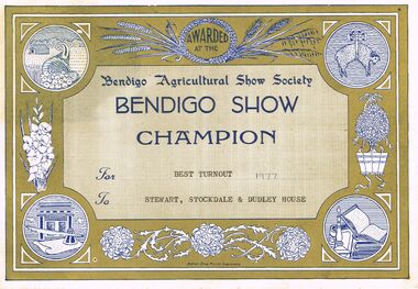
Document - LYDIA CHANCELLOR COLLECTION; BENDIGO SHOW CHAMPION
A brown blue and white certificate with the words, ' Awarded at the Bendigo Agricultural Show Society Bendigo Show Champion For Best Turnout To Stewart, Stockdale & Dudley House.' Bolton Bros. Pty. Ltd. Engravers.civic mementoes, presentations, bendigo agricultural show society, lydia chancellor, collection, bendigo agricultural show society, societies, clubs and associations, organisation, certificate, champion, agriculture, bendigo community -
Hume City Civic Collection
Photograph, Certificate of Appreciation, 7th December 1906
The laminated photograph of the certificate of appreciation was presented to Joseph Starkie in recognition of his 18 years of service to the community as a Councillor and Chairman of the Sunbury Waterworks Trust. It was signed on behalf of the residents and ratepayers of the Shire of Bulla. The Joseph D. Starkie water fountain was erected in the town in recognition of his efforts in bringing a water supply to Sunbury. A laminated photocopy of a certificate of appreciation.bulla shire council, joseph starkie, sunbury waterworks trust, starkie, starkie memorial fountain, joseph leyden -
 Bendigo Historical Society Inc.
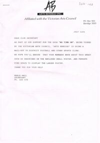
Document - MERLE HALL COLLECTION: VARIOUS ARTS BENDIGO OUTWARDS CORRESPONDENCE
Various Arts Bendigo Outwards Correspondence - To: Mailout to District Football and other clubs for show ''No Time On''; Steve Gibbons MP re nomination of Merle Hall for a Certificate of Recognition (for outstanding contribution to AB and the community (July 2001); Cr Weston Mayor COGB, re AB support for Council's application for funding for Bendigo Arts Precinct- Art Gallery Project 1997; 1998/199 Report summary of AB activities calendar for 1999; Roman Rudnytsky re confirmation of concert date Aug 1997; David Scheel re performance 1997; Dr I McBean, University College of Northern Victoria, re re Bluthner piano 'Loan arrangement'' and restoration planned (1991); ''Alexandra''?? March 1991 re performance Agreement and directions; -
 Bendigo Historical Society Inc.
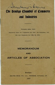
Document - Bendigo Chamber of Commerce Memorandum Articles of Association, 1937
The Bendigo Chamber of Commerce and Industry was constituted in 1886 with the vision to be the single voice for the business community across greater Bendigo. ‘Be.Bendigo’ is the trading name of the organisation ‘Bendigo Business Council’ which was formed in 2008 as a merger between two Bendigo business organisations: The Bendigo Chamber of Commerce and Central Victorian Business Network (CVBN). Upon the merger, Bendigo Business Council continued the functions of both the Chamber and CVBN by providing advocacy, networking and events to members and partners.Small booklet containing the Memorandums and Articles of Association for the Bendigo Chamber of Commerce and Industries, dated 1937. Printed by Bolton Brothers Mitchell Street Bendigo. Includes the Certificate of Incorporation dated 3 September 1913. Also a copy of the original Bendigo Chamber of Commerce Memorandum and Articles of Association dated 25 August 1913.Secretary's Copyhistory, bendigo, bendigo chamber of commerce collection -
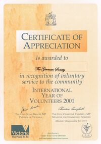 Bendigo Historical Society Inc.
Document - GERMAN HERITAGE SOCIETY COLLECTION: CERTIFICATE OF APPRECIATION
Two tone orange Certificate of Appreciation awarded to The German Society in recognition of voluntary service to the community International Year of Volunteers 2001. Signed by The Hon., Steve Bracks MP, Premier of Victoria and The Hon Christine Campbell MP, Minister of Community Services.document, certificate, german heritage society, german heritage society collection - certification of appreciation, the german society, international year of volunteers 2001, the hon steve bracks mp, the hon christine campbell mp, jan penney, north central goldfields regional library corporation -
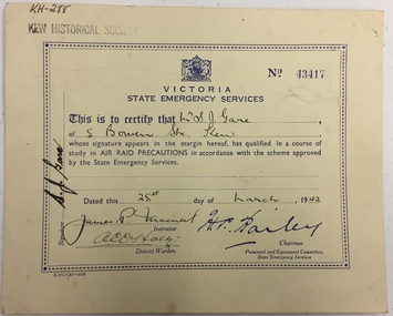 Kew Historical Society Inc
Certificate, State Emergency Services Victoria, Air Raid Precautions Certificate No.43417, Mr S J Gare, 5 Bowen St., Kew, 1942
Part of a suite of materials used by Air Raid Precautions (ARP) wardens in Kew in the Second World War. Air raid wardens managed groups of people in using air raid facilities that were constructed throughout the district. The ARP scheme was based on that developed in the United Kingdom.Primary resources showing the materials and advice developed to protect civilians on the home front. Examples of such support in the Kew Historical Society's collection includes advice for authorised community representatives, insignia and equipment.Certificate awarded to Mr. S. J. Gare of 5 Bowen Street, Kew in 1942 after successfully completing an air raid precautions course, dated 25th March 1942.second world war 1939-1945 - kew (vic), arp, state emergency services victoria 1939-1945, second world war — air raid precautions, world war 2 — 1939-1945, home front — kew (vic.) -
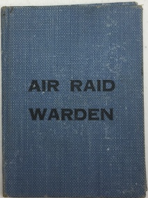 Kew Historical Society Inc
Certificate, State Emergency Council for Civil Defence, Air Raid Warden: Mr. S.J. Gare, 5 Bowen St., Kew, 1939-1945
Part of a suite of materials used by Air Raid Precautions (ARP) wardens in Kew in the Second World War. Air raid wardens managed groups of people in using air raid facilities that were constructed throughout the district. The ARP scheme was based on that developed in the United Kingdom.Primary resources showing the materials and advice developed to protect civilians on the home front. Examples of such support in the Kew Historical Society's collection includes advice for authorised community representatives, insignia and equipment.Small blue covered certificate identifying Mr. S. Gare, 5 Bowen Street Kew as an Air Raid Warden.arp, air raid precautions, state emergency services victoria 1939-1945, second world war — air raid precautions, state emergency council for civil defence victoria — 1939-1945, world war 2 — 1939-1945, home front — kew (vic.) -
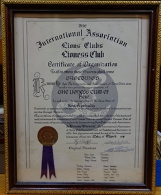 Kew Historical Society Inc
Document, The International Association of Lions Clubs, Certificate of Organization: Lioness Club of Kew, 1978
The certificate is part of a larger collection of material once belonging to the Kew Lioness Club, which was donated to the Kew Historical Society for safekeeping.The Lioness Club of Kew was the first Lioness Club in the Melbourne area. As such its records are of Historic and Social Significance as a record of post-war community organisations run by women. As the records were donated to the Kew Historical Society as a place of deposit, they are well provenanced. They comprise albums, objects, and a history of the Club so provide a complete picture of the Club's operation.A framed certificate presented to the Lioness Club of Kew in 1978 officially recognising the Club under the sponsorship of the local Lions Club. The certificate lists the original members Helen Joyce (President), Thelma Leech (Secretary), Beryl Mainon (Treasurer) and Dorothy Cameron, Arleen Ekberg, Ruth Finger, Norma Finley, Jean Franklin, Cherie Kinnear Wells, Valerie Newbegin, Lorna Patching, Marjorie Rogers, Shirley Van Scoy, Joyce Ward and Jan Watkins.lioness club (kew), women's groups -- kew -- melbourne (vic.), women's clubs -
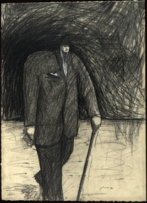
 Federation University Art Collection
Painting - Acrylic on canvas, Marcus Wills, 'Really?' by Marcus Wills, 31/08/1989
Marcus WILLS (1972 - ) Born Kaniva, Victoria Marcus Wills is a figurative realist painter who completed an Advanced Certificate of Art and Design between 1989 and 1991 at the Wimmera Community College of TAFE (now Federation University Australia's Horsham Campus). He graduated from the Victorian College of the Arts in 1995, winning the second Brett Whiteley Travelling Art Scholarship in 1999. In 2006 Marcus Wills won the Archibald Prize for his painting of 'The Paul Juraszek Monolith', based on an engraving by Marcus Gheeraerts the Elder. In 2015 and 2016 Marcus Wills has been a finalist in the Archibald Prize. Abstract painting with figuresart, artwork, marcus wills, horsham campus, archibald pize winner, alumni, wimmera community college of tafe, horsham campus art collection -
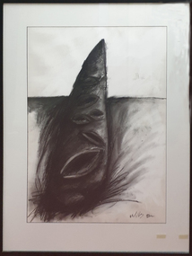
 Federation University Art Collection
Drawing - Artwork, Marcus Wills, 'Winston' by Marcus Wills, 1989
Marcus WILLS (1972 - ) Born Kaniva, Victoria Marcus Wills is a figurative realist painter who completed an Advanced Certificate of Art and Design between 1989 and 1991 at the Wimmera Community College of TAFE (now Federation University Australia's Horsham Campus). He graduated from the Victorian College of the Arts in 1995. he won the second Brett Whiteley Travelling Art Scholarship in 1999. In 2006 Marcus Wills won the Archibald Prize for his painting of 'The Paul Juraszek Monolith', based on an engraving by Marcus Gheeraerts the Elder. In 2015 and 2016 Marcus Wills has been a finalist in the Archibald Prize. Framed drawing of Winston Churchill.art, artwork, marcus wills, winston churchill, horsham, horsham campus art collection, archibald prize winner, alumni, distinguished alumni -
 Federation University Art Collection
Drawing - Artwork - Drawing, [Cone] by Marcus Wills, 1989
Marcus WILLS (1972 - ) Born Kaniva, Victoria Marcus Wills is a figurative realist painter who completed an Advanced Certificate of Art and Design between 1989 and 1991 at the Wimmera Community College of TAFE (now Federation University Australia's Horsham Campus). He graduated from the Victorian College of the Arts in 1995. he won the second Brett Whiteley Travelling Art Scholarship in 1999. In 2006 Marcus Wills won the Archibald Prize for his painting of 'The Paul Juraszek Monolith', based on an engraving by Marcus Gheeraerts the Elder.Framed drawing of a cone. art, artwork, marcus wills, drawing, horsham campus, wimmera campus, alumni, horsham campus art collection, horsham available -
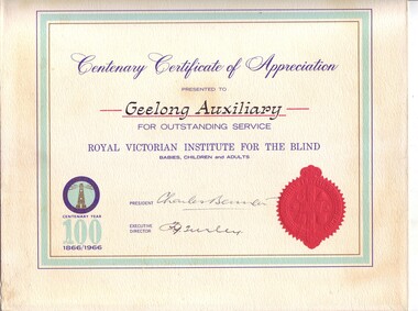 Vision Australia
Administrative record - Text, RVIB Geelong Auxiliary papers, 1933 - [1998?]
The Geelong RVIB Auxiliary was formed on February 13, 1933 by Mr Birtchnell. This collection of papers includes the minute books from 1944 until 1998. It was noted in correspondence that Geelong and surrounds had been the most outstanding financial contributor to RVIB's revenue. Collections from the Geelong community had provided high donations every year. The Geelong Auxiliary posted 301 pounds on their first return in 1934, easily topping any of the other 200 auxiliaries in the state at that time. The Annual Report from July 31, 1995 noted that with regret due to health reasons and the passing of many members The Geelong RVIB Auxiliary had no option but to go into recess. The certificate reads: Centenary Certificate of Appreciation presented to Geelong Auxiliary for outstanding service. Royal Victorian Institute for the Blind babies, children and adults. (Signed by) President (Charles Bennett) Executive Director (F.G. Turley).5 minute books -- 2 accounts books -- 1 book of newspaper clippings --various loose papers and letters -- 1 certificate of appreciation Certificate: white paper with light turquoise thick border and gold and blue thin borders. The RVIB official seal is at the base of the right hand side and a coloured image of the RVIB logo, with the words 'Centenary year 100 1866/1966' in the bottom left corner.royal victorian institute for the blind, auxiliaries -
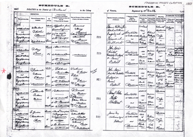 Friends of Ballarat Botanical Gardens History Group
Work on paper - Frederick Moses Claxton 1832-1888, Death Certification, 1888
F. R. Claxton died at the relatively young age of 56 years and was a civic leader and highly regarded member of the Ballarat Community.F.R. Claxton's untimely death may have been caused by food poisoning not English Cholera as noted the Death Certificate.Schedule B Death Certificate (2 copies) and one enlargement of this Death CertificateOn the back of Claxton's Death Certificate, in black biro "Obtained 22 Feb 2010 for Friends of the Ballarat Botanical Gardens History Group." john garner, doctor, ballarat botanical gardens, frederick moses claxton, death certificate, english cholera, lake wendouree, claxton memorial, claxton, john garner collection, gardens, ballarat -
 Melton City Libraries
Photograph, Melton Uniting Church Opportunity Shop volunteers, 1993
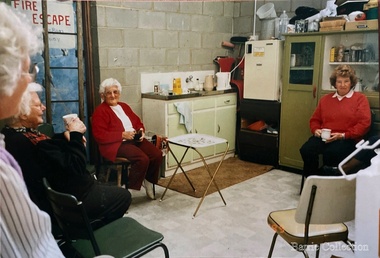
In the early l 970's , when our population was increasing rapidly and resident ministers were needed at both Melton and Bacchus Marsh, and after discussion between both denominations over many months a decision was reached , that in both areas they would unite and be known as Methodist - Presbyterian joint parishes. In 1972 Ministers were appointed, and Melton's minister occupied one of the Bacchus Marsh Manses during the building of Melton's church residence in Y uille Street. Services were held at Scots Presbyterian Church Melton. Youth Club and church meetings were held in the Methodist Church at Brooklyn Road, Melton South. At a joint Parish Committee Meeting held in May 1975 at Melton South - a major item of business was finance, to meet the repayments on the recently built Church Manse and the minister's Stipend. The meeting closed without any solution to this problem being made. As the men restacked the chairs Maisie and I viewed the building with the possibility of opening an Opp Shop on the premises. We then made the suggestion to the other members and during the forthcoming weeks investigations concerning the feasibility of this idea were made, volunteers recruited and the shop opened in July 1975. The first contribution to the Church funds of $1,600 was made in 1976 and was followed by regular contributions to the church budget each year. In 1981 a 30'x 20' steel garage costing $2,000 was erected adjacent to the original Methodist Church to provide more space. Meanwhile an Opp Shop was opened in Melton Markets and operated from 1981 to 1985. Further accommodation was needed at Yuille Street and the Atco Hall was installed at the rear of the Bluestone Church (known as Melton Uniting Church - 1977). A large proportion of finance for this project was contributed by the Opp Shop $16,000. Simultaneously finance was being built up to provide further facilities at Brooklyn Rd, resulting in the commencement of a concrete block masonry and steel extension, with facilities & fittings, being commenced during 1986 & completed in 1989. The approximate total cost of this structure was $60,000. Over the 16 years, members and friends of our church have contributed many many hours to staff the shop and many other supportive works. As an acknowledgement of their efforts, our Minister prepared Certificates for Service and Dedication which were presented to 75 supporters at a special Church Service in June 1991. The assistance that has been given to the community of Melton & District has been extensive and much appreciated by many families. In addition many appeals for goods and clothing have been received and packages sent to many outside supportive agencies. Three volunteers having a tea break in the staffroom of the Op Shoplocal identities, churches -
 Bendigo Historical Society Inc.
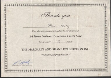
Certificate - Gertrude Perry Collection - certificate of appreciation for Miss Perry and her donation of two hours service to the 24 Hour National Freecall Crisis Line
Gertrude Perry was born in California Gully in 1917. Her singing skills were recognized at an early age. She later sang with local choirs and sang on radio. She was involved with the Bendigo Operatic Society for many years. Gertrude began her working life in sales. After studying book keeping she worked at the Bendigo Ordnance Factory during WW2 and then worked for local solicitors and accountants. Gertrude was involved with many community and sporting organizations.Gertrude Perry Collection - certificate of appreciation for Miss Perry and her donation of two hours service to the 24 Hour National Freecall Crisis Line and the Margaret and Shane Foundations Inc.physical culture class, fitness, exercise, volunteer public service -
 Eltham District Historical Society Inc
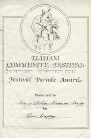
Document - Award Certificate, Eltham Community Festival, Festival Parade Award Presented to Shire of Eltham Historical Society for Best Display, 1986
1986: 7-9 November. New Banner, Ben Hall coach and vintage cars The 1986 festival was held from 7th to 9th November with the parade will be held at noon on Saturday, November 8th. The "float" consisted of Ben Hall's Cobb & Co. coach and several vintage motor vehicles. Society members were dressed in Victorian era for those riding in the coach and 1920s fashion for those in the motor vehicles. A further feature of the parade was the use of the Society banner which had been created that year. The Society's entry in the Eltham Community Festival parade included Ben Hall's Cobb and Co. coach and was awarded the major prize for the parade. This involved the presentation of a perpetual trophy which the Society held for one year. However, it was the last time the trophy was awarded and remains in the Society's collection. The trophy was replaced in 1987 with a Best Display award which again was won by the Society, and again in 1988. See EDHS_05453 award, eltham community festival, eltham festival, festival parade award, grand parade, shire of eltham historical society, 1986 -
 Bendigo Historical Society Inc.
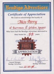
Certificate - Gertrude Perry Collection - Bendigo Advertiser Certificate of Appreciation for the delivery of the newspaper at home for 44 years
Gertrude Perry was born in California Gully in 1917. Her singing skills were recognized at an early age. She later sang with local choirs and sang on radio. She was involved with the Bendigo Operatic Society for many years. Gertrude began her working life in sales. After studying book keeping she worked at the Bendigo Ordnance Factory during WW2 and then worked for local solicitors and accountants. Gertrude was involved with many community and sporting organizations.Gertrude Perry Collection - Bendigo Advertiser Certificate of Appreciation for the delivery of the newspaper at home, 16 Burrows Street Golden Square, for 44 years, dated 22/10/1996. Certificate by Bendigo Advertiser and signed by the General Manager and the Editor.physical culture class, fitness, exercise, bendigo advertiser -
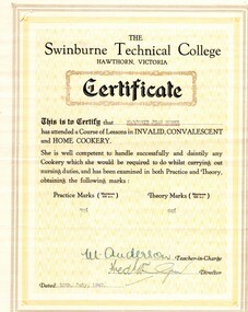 Greensborough Historical Society
Document - Certificate, Swinburne Technical College, Swinburne Technical College: results for Miss M. J. Burke, 10/07/1942
Course results for Marjorie Jean Burke issued by Swinburne Technical College, the course covered invalid, convalescent and home cookery.Miss Burke was a nurse, midwife and infant welfare sister. This collection covers her many qualifications throughout Australia and Great Britain, including references both professional and personal. When Miss Burke returned to Australia, she was employed at Diamond Valley Community Hospital as a nurse in 1953 and as Deputy Matron 1954-1971.Course results typed on cream paper, includes envelope.Signed by teacher in charge and director.marjorie jean burke, nurses, diamond valley community hospital, swinburne technical college -
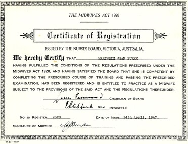 Greensborough Historical Society
Document - Certificate, Nurses Board Melbourne, Midwives Certificate for Marjorie Jean Burke, 24/04/1947
Midwives certificate for Marjorie Jean Burke issued by Nurses Board Melbourne, under the Midwives Act 1928.Miss Burke was a nurse, midwife and infant welfare sister. This collection covers her many qualifications throughout Australia and Great Britain, including references both professional and personal. When Miss Burke returned to Australia, she was employed at Diamond Valley Community Hospital as a nurse in 1953 and as Deputy Matron 1954-1971.Certificate typed on cream card.Signed by registrar.marjorie jean burke, nurses, diamond valley community hospital, nurses board melbourne -
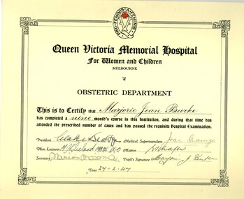 Greensborough Historical Society
Document - Certificate, Queen Victoria Hospital, Obstetrics Certificate for Marjorie Jean Burke, 27/02/1947
Obstetrics certificate for Marjorie Jean Burke issued by the Queen Victoria Memorial Hospital for Women and Children in Melbourne.Miss Burke was a nurse, midwife and infant welfare sister. This collection covers her many qualifications throughout Australia and Great Britain, including references both professional and personal. When Miss Burke returned to Australia, she was employed at Diamond Valley Community Hospital as a nurse in 1953 and as Deputy Matron 1954-1971.Certificate typed on cream card.marjorie jean burke, nurses, diamond valley community hospital, queen victoria hospital melbourne -
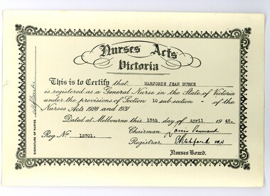 Greensborough Historical Society
Document - Certificate, Nurses Board Melbourne, General Nurse Certificate for Marjorie Jean Burke, 13/07/1945
General Nurse certificate for Marjorie Jean Burke issued by the Nurses Board under the Nurses Acts Victoria, 1928 and 1931. Miss Burke was a nurse, midwife and infant welfare sister. This collection covers her many qualifications throughout Australia and Great Britain, including references both professional and personal. When Miss Burke returned to Australia, she was employed at Diamond Valley Community Hospital as a nurse in 1953 and as Deputy Matron 1954-1971.Certificate typed on cream card.marjorie jean burke, nurses, diamond valley community hospital, nurses board melbourne -
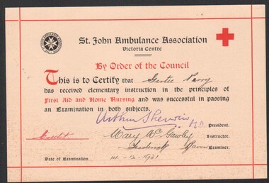 Bendigo Historical Society Inc.
Certificate - Gertrude Perry Collection - St. John Ambulance Association to certify that Gertie Perry has received elementary instruction in the principles of First Aid and Home Nursing on 14/12/1931
Gertrude Perry was born in California Gully in 1917. Her singing skills were recognized at an early age. She later sang with local choirs and sang on radio. She was involved with the Bendigo Operatic Society for many years. Gertrude began her working life in sales. After studying book keeping she worked at the Bendigo Ordnance Factory during WW2 and then worked for local solicitors and accountants. Gertrude was involved with many community and sporting organizations.Gertrude Perry Collection - St. John Ambulance Association to certify that Gertie Perry has received elementary instruction in the principles of First Aid and Home Nursing on 14/12/1931. Miss Perry was awarded a Credit for successfully passing the examinations on both subjects; and is signed by the President, Instructor and Examiner.physical culture class, fitness, exercise, st. john ambulance association -
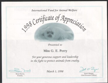 Bendigo Historical Society Inc.
Certificate - Gertrude Perry Collection - International Fund for Animal Welfare 1998 Certificate of Appreciation presented to Miss G.E. Perry
Gertrude Perry was born in California Gully in 1917. Her singing skills were recognized at an early age. She later sang with local choirs and sang on radio. She was involved with the Bendigo Operatic Society for many years. Gertrude began her working life in sales. After studying book keeping she worked at the Bendigo Ordnance Factory during WW2 and then worked for local solicitors and accountants. Gertrude was involved with many community and sporting organizations.Gertrude Perry Collection - International Fund for Animal Welfare 1998 Certificate of Appreciation presented to Miss G.E. Perry, dated 1 March 1998: for your support and leadership to protect animals from cruelty. The certificate is sent in the hope for a further contribution to the IFAW - not taken up by Miss Perry.physical culture class, fitness, exercise, animal welfare -
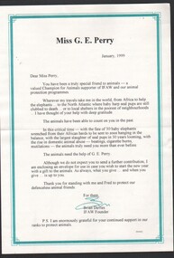 Bendigo Historical Society Inc.
Certificate - Gertrude Perry Collection - Letter format from the International Fund for Animal Welfare to Miss G.E. Perry, dated January 1999
Gertrude Perry was born in California Gully in 1917. Her singing skills were recognized at an early age. She later sang with local choirs and sang on radio. She was involved with the Bendigo Operatic Society for many years. Gertrude began her working life in sales. After studying book keeping she worked at the Bendigo Ordnance Factory during WW2 and then worked for local solicitors and accountants. Gertrude was involved with many community and sporting organizations.Gertrude Perry Collection - Letter format from the International Fund for Animal Welfare to Miss G.E. Perry, dated January 1999; seeking a contribution to assist the IFAW to further it causes of animal protection programs.physical culture class, fitness, exercise, animal welfare