Showing 1740 items matching "concrete"
-
 Eltham District Historical Society Inc
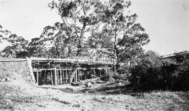
Negative - Photograph, Construction of the new concrete bridge over the Diamond Creek on Main Road, Eltham, c.May 1926
Construction of the new concrete bridge over the Diamond Creek on Main Road, Eltham, c.May 1926. Viewed from present day Wingrove Park. The original long suspension bridge over the Diamond Creek on Main Road at Eltham collapsed during flooding of the Diamond Creek on October 13 and 14, 1923. The original bridge was built around 1840 for the coach road when Cobb & Co.'s coach was the only conveyance between Eltham and Melbourne. Widespread damage was done in Melbourne and surrounding areas by floods resulting from the overflow of the Yarra at many points along its banks. A temporary bridge rigged up was severely damaged by the flooding of the creek and was closed to vehicular traffic in April 1924. A new concrete bridge was constructed to replace it and by May 1926 all the concrete piles and abutments had been completed. The bridge was finally completed and opened for traffic in September 1926, almost three years after it initially collapsed.This photo forms part of a collection of photographs gathered by the Shire of Eltham for their centenary project book,"Pioneers and Painters: 100 years of the Shire of Eltham" by Alan Marshall (1971). The collection of over 500 images is held in partnership between Eltham District Historical Society and Yarra Plenty Regional Library (Eltham Library) and is now formally known as the 'The Shire of Eltham Pioneers Photograph Collection.' It is significant in being the first community sourced collection representing the places and people of the Shire's first one hundred years.Digital image 4 x 5 inch B&W Neg Print 9 x 12.5 cmshire of eltham pioneers photograph collection, eltham, eltham lower park, main road bridge, eltham south, bridge, diamond creek (creek), wingrove park, bridge construction -
 University of Melbourne, Burnley Campus Archives
Plan, Flat Concrete Roof & New Staff Room, 1981
(1) Photocopy of plan showing Flat Concrete Roof and New Staff Room. (2) Title of a plan which is probably of (1). Internal Modifications dated 4.6.81 by J.T. Crean, Ass't Director of Public Works. Donated by Sandi Pullman 2012.staff, sandra pullman -
 Eltham District Historical Society Inc
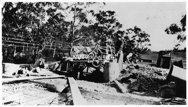
Negative - Photograph, Construction of the new concrete bridge over the Diamond Creek on Main Road, Eltham, c.May 1926
Construction of the new concrete bridge over the Diamond Creek on Main Road, Eltham, c.May 1926. Viewed from northern approach looking south east towards Eltham Park (Eltham Lower Park), showing the power lines that used to run in front of the park. The original long suspension bridge over the Diamond Creek on Main Road at Eltham collapsed during flooding of the Diamond Creek on October 13 and 14, 1923. The original bridge was built around 1840 for the coach road when Cobb & Co.'s coach was the only conveyance between Eltham and Melbourne. Widespread damage was done in Melbourne and surrounding areas by floods resulting from the overflow of the Yarra at many points along its banks. A temporary bridge rigged up was severely damaged by the flooding of the creek and was closed to vehicular traffic in April 1924. A new concrete bridge was constructed to replace it and by May 1926 all the concrete piles and abutments had been completed. The bridge was finally completed and opened for traffic in September 1926, almost three years after it initially collapsed.This photo forms part of a collection of photographs gathered by the Shire of Eltham for their centenary project book,"Pioneers and Painters: 100 years of the Shire of Eltham" by Alan Marshall (1971). The collection of over 500 images is held in partnership between Eltham District Historical Society and Yarra Plenty Regional Library (Eltham Library) and is now formally known as the 'The Shire of Eltham Pioneers Photograph Collection.' It is significant in being the first community sourced collection representing the places and people of the Shire's first one hundred years.Digital image 4 x 5 inch B&W Negshire of eltham pioneers photograph collection, bridge, bridge construction, cement mixer, diamond creek (creek), eltham, eltham lower park, eltham south, main road bridge -
 Greensborough Historical Society
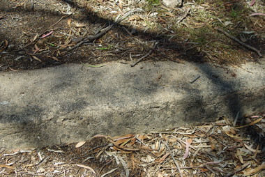
Photograph - Digital image, Marilyn Smith et al, Janefield Precinct: Preserved concrete edging, 27/11/2014
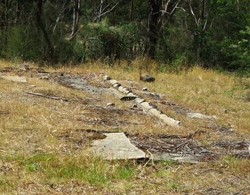
Janefield Precinct: Preserved concrete edging. The remains of this site are between Greensborough and Janefield. A RAAF Hygiene Training Camp was located on the Plenty River, just south of the Janefield community. It was in use from 1944 to 1946. The Camp was constructed from salvaged materials. Instruction included building and maintenance of grease traps, latrines, elementary plumbing and carpentry.Early remains of a WW2 training camp Digital colour photograph.raaf hygiene training camp janefield -
 Eltham District Historical Society Inc
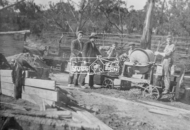
Photograph, Construction of the new concrete bridge over the Diamond Creek on Main Road, Eltham, c.May 1926
Construction of the new concrete bridge over the Diamond Creek on Main Road, Eltham, c.May 1926. Viewed from northern approach looking east, the access drive running off Antoinette Boulevard parallel to Main Road is visible as well as the power lines that used to run in front of Eltham Park (Eltham Lower Park). Also visible is a tree situated beside the roadway. It is believed this is the same tree that remains today as a dead tree trunk immediately adjacent to the road verge armco near the corner of Antoinette Boulevard. The original long suspension bridge over the Diamond Creek on Main Road at Eltham collapsed during flooding of the Diamond Creek on October 13 and 14, 1923. The original bridge was built around 1840 for the coach road when Cobb & Co.'s coach was the only conveyance between Eltham and Melbourne. Widespread damage was done in Melbourne and surrounding areas by floods resulting from the overflow of the Yarra at many points along its banks. A temporary bridge rigged up was severely damaged by the flooding of the creek and was closed to vehicular traffic in April 1924. A new concrete bridge was constructed to replace it and by May 1926 all the concrete piles and abutments had been completed. The bridge was finally completed and opened for traffic in September 1926, almost three years after it initially collapsed.This photo forms part of a collection of photographs gathered by the Shire of Eltham for their centenary project book,"Pioneers and Painters: 100 years of the Shire of Eltham" by Alan Marshall (1971). The collection of over 500 images is held in partnership between Eltham District Historical Society and Yarra Plenty Regional Library (Eltham Library) and is now formally known as the 'The Shire of Eltham Pioneers Photograph Collection.' It is significant in being the first community sourced collection representing the places and people of the Shire's first one hundred years.Photo print 9 x 12.5 cmshire of eltham pioneers photograph collection, eltham, bridge, diamond creek (creek), eltham south, main road bridge, wingrove park, antoinette boulevard, significant tree, cement mixer, bridge construction -
 Greensborough Historical Society
Photograph - Digital image, Marilyn Smith et al, Janefield Precinct: World War 2 era concrete and guttering, 27/11/2014
Janefield Precinct: World War 2 era concrete and guttering. The remains of this site are between Greensborough and Janefield. A RAAF Hygiene Training Camp was located on the Plenty River, just south of the Janefield community. It was in use from 1944 to 1946. The Camp was constructed from salvaged materials. Instruction included building and maintenance of grease traps, latrines, elementary plumbing and carpentry.Early remains of a WW2 training camp Digital colour photograph.janefield -
 Greensborough Historical Society
Photograph - Digital image, Marilyn Smith et al, Janefield Precinct: World War 2 era concrete admin block, 27/11/2014
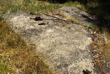
Janefield Precinct: World War 2 era concrete admin block. The remains of this site are between Greensborough and Janefield. A RAAF Hygiene Training Camp was located on the Plenty River, just south of the Janefield community. It was in use from 1944 to 1946. The Camp was constructed from salvaged materials. Instruction included building and maintenance of grease traps, latrines, elementary plumbing and carpentry.Early remains of a WW2 training camp Digital colour photograph.janefield -
 Greensborough Historical Society
Photograph - Digital image, Marilyn Smith et al, Janefield Precinct: World War 2 era concrete shed base, sump and raised edge, 27/11/2014
Janefield Precinct: World War 2 era concrete shed base, sump and raised edge. The remains of this site are between Greensborough and Janefield. A RAAF Hygiene Training Camp was located on the Plenty River, just south of the Janefield community. It was in use from 1944 to 1946. The Camp was constructed from salvaged materials. Instruction included building and maintenance of grease traps, latrines, elementary plumbing and carpentry.Early remains of a WW2 training camp Digital colour photograph.janefield -
Ringwood and District Historical Society
Piece of concrete, City of Ringwood, Concrete from the facade of the old Ringwood Town Hall demolished in 1971, 1927
The two storey facade of the Ringwood Town Hall was built in 1927 at a cost of 6,000 pounds. Behind it the council worked out of the old mechanics institute. As the need for space grew, the first Ringwood fire station, the baby health centre and council's health department squeezed onto the site. A free library and cinema also operated from the town hall for many years.Two lumps of concrete from the facade of the old Ringwood Town Hall. Red at the centre, soot and dirt marked on the outside.; This was the first debris from the demolition of the old Ringwood Town Hall, knocked off the front western pillar by the mayor Cr Jack McRae at the invitation of the purchaser Hanover Holdings Ltd, on Thursday 22-Apr-1971. +Additional Keywords: McRae, Cr J.M. / Carter, RichardFirst debris from the demolition of the old Ringwood Town Hall, knocked off the front western pillar by the mayor Cr Jack McRae at the invitation of the purchaser Hanover Holdings Ltd, on Thursday 22-Apr-1971. -
 Whitehorse Historical Society Inc.
Book, 1939
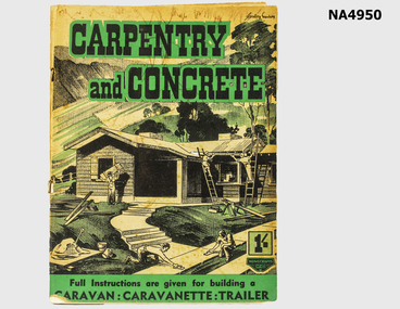
Belonged to Bill McLaren (father of Anthea Swann) in the 1930s - 1940s87 page magazine containing construction instruction for handymen and tradesmen. Title : Carpentry and Concrete: a Home Beautiful Handbook for Tradesmen and AmateursCarpentry and Concretebooks, magazines, trades, carpentry -
 Ringwood and District Historical Society
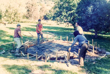
Photograph, Kubis Estate, North Ringwood on 16 June 1978. The concrete wall 27 feet deep at the pumping station in Glenvale Road
E550 N12 Part of a 51-photo record of the development of the "Kubis" Estate, Ringwood North, including road works to Debbie Place, Kubis Drive, Werac Drive, Manuelo Drive, Iluka Place and Glenvale Road. From the Jack Lundy Clarke collection. -
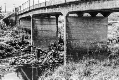
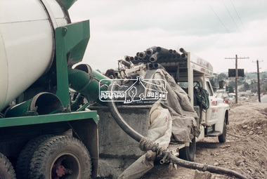 Eltham District Historical Society Inc
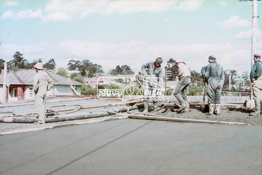
Slide, Sherbourne Road overpass, Briar Hill, Concrete pump truck, 28 July 1970, 1970
Construction of new realigned Sherbourne Road railway overpass following realignment construction works for intersection of Sherbourne Road and Para Road.35 mm colour positive transparency Mount - Agfacolor Service (Blue)briar hill, bridge construction, overpass, para road, railway bridge, road construction, sherbourne road -
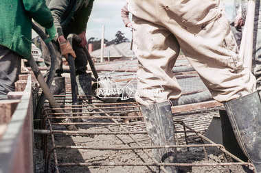 Eltham District Historical Society Inc
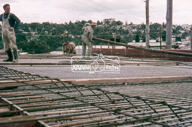
Slide, Sherbourne Road overpass, Briar Hill, Bridge span concrete pour, c.October 1970, 1970
Construction of new realigned Sherbourne Road railway overpass following realignment construction works for intersection of Sherbourne Road and Para Road.35 mm colour positive transparency Mount - Agfacolor Service (Blue)briar hill, bridge construction, overpass, para road, railway bridge, road construction, sherbourne road -
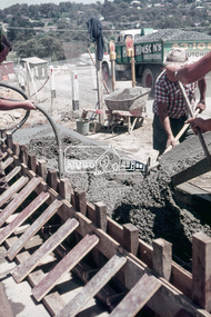 Eltham District Historical Society Inc
Slide, Sherbourne Road overpass, Briar Hill, Bridge span concrete pour, c.October 1970, 1970
Construction of new realigned Sherbourne Road railway overpass following realignment construction works for intersection of Sherbourne Road and Para Road.35 mm colour positive transparency Mount - Agfacolor Service (Blue)briar hill, bridge construction, overpass, para road, railway bridge, road construction, sherbourne road -
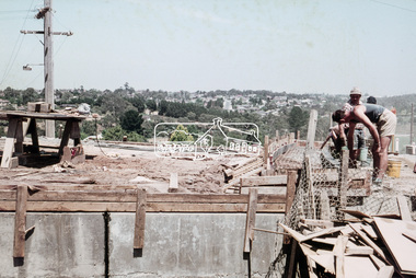 Eltham District Historical Society Inc
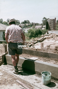
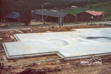
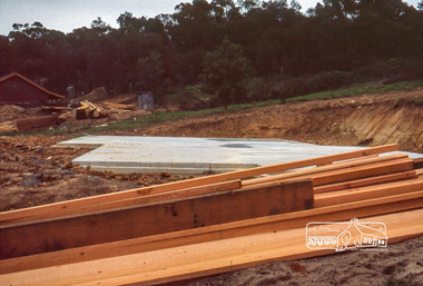
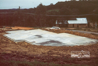
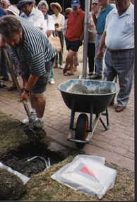
Photograph, Concrete fabrication of the Shire of Eltham Historical Society's Victorian 150th Anniversary Monument, c. October 1985, 1985
Two colour photographsactivities, 150th anniversary monument, 1985, time capsule -
 Eltham District Historical Society Inc
Photograph, Concrete slab from backyard
14 Stokes Place (Lot 83) was the home of Peter and Carla Vermey. The land was purchased in May 1979 and construction commenced September 1979. The home was built by Peter and Carla Vermey after the developer, Macquarie Builders went bankrupt. Sold October 2017 by Morrison and Kleeman Real Estate. Stokes Place was part of the Stokes Orchard Estate which was developed from the break-up of the the orchard owned by Frank Stokes who lived on the northeast corner of Nyora Road and Eucalyptus Road. His daughter Beryl advised that the Shire had levied a rate assessment on individual parcels of land within the orchard which became unaffordable resulting in its sub-division and sell off. The Stokes Orchard Estate was developed by Macquarie Builders in two stages starting with stage 1 in 1976. Stokes Place was part of Stage 2 in 1979. The Estate was bounded between Nyora Road, Eucalyptus Road, Diosma Road and Stokes Place. The original orchard only just reached the left most portions of Stokes Place and did not go fully up to Diosma, rather to just beyond the extant of Stokes Place. Stokes Place was known within the family as "The Oats" as that is where they grew oats. Frank Stokes moved to Eltham c.1945 after visiting Harold Bird to view his orchard, located diagonally opposite Stokes Orchard from the intersection of Eucalyptus Road, Pitt Street and Nyora Road. It was on Harold Bird's recommendation that Frank purchased the land.The Stokes Orchard Estate collection is typical of housing developments of the late 1970s and 1980s. It was one of the earliest estates in Eltham following the nearby Woodridge Estate development.Digital fileScanned by EDHS from 49 x 35mm colour transparencies provided on loanstokes place, eltham, stokes orchard, stokes orchard estate, streets, houses, peter and carla vermey -
 Eltham District Historical Society Inc
Photograph, Concrete slab from driveway
14 Stokes Place (Lot 83) was the home of Peter and Carla Vermey. The land was purchased in May 1979 and construction commenced September 1979. The home was built by Peter and Carla Vermey after the developer, Macquarie Builders went bankrupt. Sold October 2017 by Morrison and Kleeman Real Estate. Stokes Place was part of the Stokes Orchard Estate which was developed from the break-up of the the orchard owned by Frank Stokes who lived on the northeast corner of Nyora Road and Eucalyptus Road. His daughter Beryl advised that the Shire had levied a rate assessment on individual parcels of land within the orchard which became unaffordable resulting in its sub-division and sell off. The Stokes Orchard Estate was developed by Macquarie Builders in two stages starting with stage 1 in 1976. Stokes Place was part of Stage 2 in 1979. The Estate was bounded between Nyora Road, Eucalyptus Road, Diosma Road and Stokes Place. The original orchard only just reached the left most portions of Stokes Place and did not go fully up to Diosma, rather to just beyond the extant of Stokes Place. Stokes Place was known within the family as "The Oats" as that is where they grew oats. Frank Stokes moved to Eltham c.1945 after visiting Harold Bird to view his orchard, located diagonally opposite Stokes Orchard from the intersection of Eucalyptus Road, Pitt Street and Nyora Road. It was on Harold Bird's recommendation that Frank purchased the land.The Stokes Orchard Estate collection is typical of housing developments of the late 1970s and 1980s. It was one of the earliest estates in Eltham following the nearby Woodridge Estate development.Digital fileScanned by EDHS from 49 x 35mm colour transparencies provided on loanstokes place, eltham, stokes orchard, stokes orchard estate, streets, houses, peter and carla vermey -
 Eltham District Historical Society Inc
Photograph, Concrete slab from north elevation
14 Stokes Place (Lot 83) was the home of Peter and Carla Vermey. The land was purchased in May 1979 and construction commenced September 1979. The home was built by Peter and Carla Vermey after the developer, Macquarie Builders went bankrupt. Sold October 2017 by Morrison and Kleeman Real Estate. Stokes Place was part of the Stokes Orchard Estate which was developed from the break-up of the the orchard owned by Frank Stokes who lived on the northeast corner of Nyora Road and Eucalyptus Road. His daughter Beryl advised that the Shire had levied a rate assessment on individual parcels of land within the orchard which became unaffordable resulting in its sub-division and sell off. The Stokes Orchard Estate was developed by Macquarie Builders in two stages starting with stage 1 in 1976. Stokes Place was part of Stage 2 in 1979. The Estate was bounded between Nyora Road, Eucalyptus Road, Diosma Road and Stokes Place. The original orchard only just reached the left most portions of Stokes Place and did not go fully up to Diosma, rather to just beyond the extant of Stokes Place. Stokes Place was known within the family as "The Oats" as that is where they grew oats. Frank Stokes moved to Eltham c.1945 after visiting Harold Bird to view his orchard, located diagonally opposite Stokes Orchard from the intersection of Eucalyptus Road, Pitt Street and Nyora Road. It was on Harold Bird's recommendation that Frank purchased the land.The Stokes Orchard Estate collection is typical of housing developments of the late 1970s and 1980s. It was one of the earliest estates in Eltham following the nearby Woodridge Estate development.Digital fileScanned by EDHS from 49 x 35mm colour transparencies provided on loanstokes place, eltham, stokes orchard, stokes orchard estate, streets, houses, peter and carla vermey -
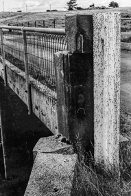
 Ringwood and District Historical Society
Photograph, Concrete culverts for new bridge. Warrandyte Rd. Ringwood 1986 (2 Views)
Written on back of photograph, "for new bridge. Warrandyte Rd. 1986." SS0369h shows plants of Barrett's old garden. -
Federation University Historical Collection
Booklet, Eureka Concrete Celebrating 40 Years, 2012
eureka concrete, eureka pre-mix concrete, troy beaston, graeme beaston, reg cooper, paul rowan, andy rowan, brendan cooper, steve hogg, lyn hayward, luke beaston, daryl killen, leo canny, rocky hazett, jeff menhennet -
 Ballaarat Mechanics' Institute (BMI Ballarat)
Film - Photograph by Herb Richmond. ca 1971, Scotchmans, Concrete Road Bridge Over the Yarrowee River, Between Napoleans and Buninyong
Ballarat History35mm B&W Kodak Plus X Pan Film.ballarat, ballaraat, scotchmans, bridge, yarrowee, river -
 Ballaarat Mechanics' Institute (BMI Ballarat)
Film - Photograph by Herb Richmond. ca 1971, Scotchmans, Concrete Road Bridge Over the Yarrowee River, Between Napoleans and Buninyong
Ballarat History35mm B&W Kodak Plus X Pan Film.ballarat, ballaraat, scotchmans, bridge, yarrowee, river -
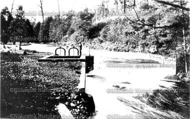 Nillumbik Historical Society Incorporated
Photograph - Black & white photograph, Concrete weir across Watts River
Black & white photographdiamond creek state school, diamond creek, nillumbik school -
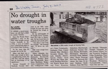 Whitehorse Historical Society Inc.
Article, Legacy is set in concrete No drought in water troughs, 2003
Two articles on Bills Water Troughs built across Victoria and elsewhere following the legacy of George Bills. Includes list of known locations including Blackburn.Two articles on Bills Water Troughs built across Victoria and elsewhere following the legacy of George Bills. Includes list of known locations including Blackburn.Two articles on Bills Water Troughs built across Victoria and elsewhere following the legacy of George Bills. Includes list of known locations including Blackburn.bills water troughs, bills, george -
 Inverloch Historical Society
001227 Photograph - January 1998 - Bass Bicentenary Time Capsule - Concrete to cover capsule - from P Jones
-
Moorabbin Air Museum
Book (Item) - Textbook Of Air Armament Part 1 , Chapter 3 Penetration Of Projectiles Into Concrete, Rock And Soil
Air Publication 110A-0300-1A3