Showing 276 items
matching conservation and planning
-
 Melbourne Tram Museum
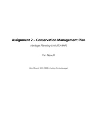
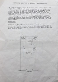
Document - Report, Yan Gaoulil, Conservation Management Plan for The Tramway Signal Cabin, Apr. 2017
Report - 28 A4 pages, double sided stapled in the top left hand corner titled "Conservation Management Plan for The Tramway Signal Cabin, Waiting Shelter and Conveniences at Swanston Street and Victoria Street Melbourne". Prepared by Yan Gaoulil as part of an assignment when undertaking Conservation Management Plan studies. Provides a introduction to the study, history, description, significance, Key Issues, Policy, implementation for the conservation of the building. Includes a Bibliography and Appendices. A second set of documents, five pages stapled in top left hand comer, lists correspondence between the Author and the Museum commencing Dec. 2016.trams, tramways, waiting shelters, franklin st, conservation planning, signal box, swanston st -
 Kew Historical Society Inc
Document, Pru Sanderson Design Pty Ltd, History and Description of 'Glencara', Sackville Street, 1984-1988
History, description, site plan and house plan of 'Glencara' at 59 Sackville Street, Kew.2-page document with site plan and internal layout of Glencara (b.1893,) 59 Sackville Street, Kew. The text in the document is identical to that in Pru Sanderson's Kew Conservation Study (1988).glencara -- sackville street -- kew (vic), houses -- sackville street -- kew -
 Whitehorse Historical Society Inc.
Book - Report, Koonung - Mullum Forestway, c1975
The Koonung-Mullum Freeway : a plan for action. A Report prepared for the Mullum Valley Freeway Action Group and Koonung Valley Action Group, under a grant from the Department of Environment by Ronald Champion Conservation Planning Environment Consultants and Paul Thompson, Rob Paul Landscapes ca1975mullum valley freeway action group, koonung valley action group, champion, randall, thompson, paul, rob paul landscapes, victoria. department of the environment, mullum mullum creek, koonung creek, eastern freeway, forest conservation, parks and reserves -
 Warrnambool and District Historical Society Inc.
Book, Warrnambool Botanic Garden Masterplan, February 1995
This Warrnambool Botanic Gardens Study and Report was funded by the National Estate Grants Program of the Australian Heritage Commission and the City of Warrnambool. It was monitored in progress by a Steering Committee consisting of representatives of the Botanic and Public Gardens Advisory Committee, the Warrnambool City Council, Friends of the Warrnambool Botanic Gardens and National Estate Grants Program representatives and community representatives. The Warrnambool Botanic Gardens were first sited close to the Hopkins River in 1859. In 1869 the gardens were relocated to the present day location in Botanic Road. This plan is of some importance as it gives an overview of the history and current condition in 1995 of the Warrnambool Botanic Gardens and draws up a plan for its future development. It is useful for research and for consideration by the City Council today of policy making and further development of the gardens. This is a publication containing a master plan for the Warrnambool Botanic Gardens. It has a section on acknowledgements, a summary, eight chapters, and 14 appendices. The pages are bound with plastic rings, the front cover is plasticized with an aerial photograph of the Botanic Gardens and surrounds and the back cover is lightweight cardboard. The pages contain printed material, fold out maps, sketches and diagrams and many photocopied photographs.Front Cover: City of Warrnambool, Warrnambool Botanic Gardens, Conservation and Development Plan, Jill Orr-Young, Patrick Mallon, SF Consultants Pty Ltd, February 1995. warrnambool botanic gardens, warrnambool -
 Whitehorse Historical Society Inc.
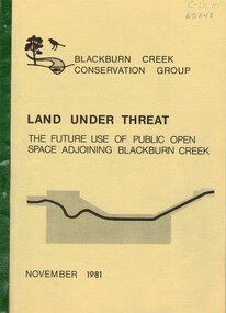
Document, Land under threat, 1981
'Land under threat: the future use of public open space adjoining Blackburn Creek' by Blackburn Creek Conservation Group, November 1981.'Land under threat: the future use of public open space adjoining Blackburn Creek' by Blackburn Creek Conservation Group, November 1981. Includes detailed descriptions, plans, bird lists, correspondence.'Land under threat: the future use of public open space adjoining Blackburn Creek' by Blackburn Creek Conservation Group, November 1981.blackburn creek, parks and reserves, kalang park, furness park, environment, blackburn creek conservation group, blacks walk, blackburn creeklands, melbourne and metropolitan board of works, city of nunawading, burgess, graham -
Southern Sherbrooke Historical Society Inc.
Book, "The Conservation of Sites and Structures of Historical and Archaelogical Significance in the Upper Yarra Valley and Dandenong Ranges Region", 1978
The work in two volumes, "Vol.1" containing the report with the exception of Chapter 5, which is the list and description of sites, and an unnumbered volume containing the entire report, was cancelled from the Belgrave branch of the Eastern Regional LibraThe publication, referred to as the Tansley Report, was prepared in 1978 as part of a Bachelor of Town & Regional Planning degree. It contains sections on conservation, pre-history and history of the area, and a list of significant sites. This is a photocopy of the original report. -
Clunes Museum
Document - PLAN, CONSERVATION MANAGEMENT PLAN, UNKNOWN
FINAL DRAFT OF CONSERVATION MANAGEMENT PLAN NOVEMBER 2018 FOR CLUNES FREE LIBRARY TEMPLETON STREET. FOLDER INCLUDES HISTORY OF CLUNES TOWNSHIP. THE BURRA CHARTER, HISTORY OF MECANICS INSTITUTE (FREE LENDING LIBRARY)conservation managment plan, free library -
University of Melbourne, Burnley Campus Archives
Plan, Alton-Hascombe Feature Survey, c. 1990
1 tracing paper and 2 paper copies of plan by Department of Conservation, Forests and Lands, Division of Survey and Mapping, of adjoining gardens Alton and Hascombe at Mount Macedon, Victoria. Scale 1:1000. Plan of properties includes buildings, gardens and paddocks. 1 copy has significant buildings coloured.feature survey, mount macedon, gardens, alton, hascombe -
Port Melbourne Historical & Preservation Society
Booklet - Ministry for Planning and Environment, Urban Conservation Areas, Aug 1986
... Ministry for Planning and Environment ...Ministry for Planning and Environment booklet of Urban Conservation Areas August 1986, detailing in words and sketches areas of inner Melbourne of special significance historically and architecturally, to be preserved. 16 pp, brown ink on cream paper.built environment, garden city, town planning, victorian ministry for planning and environment -
Lakes Entrance Historical Society
Book, Martin Brian, The SS Lady Harriet Barge and other relics Conservation Plan, 1998
A conservation plan directed towards the SS Lady Harriet barge also known as the Stone Barge, positioned on the sand hummocks near the Flagstaff Jetty. The history and use of the vessel is discussed, and recommendations for the short term stabilisation aconservation, ships and shipping -
 Old Colonists' Association of Ballarat Inc.
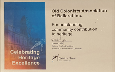
Certificate - Award, National Trust of Victoria (Ballarat Branch), Ballarat Heritage Award for Outstanding Community Contribution to Heritage, 2023
Framed certificate awarding the Old Colonists' Association of Ballarat Inc Award for Outstanding Community Contribution to Heritage. The award recognised development of a conservation management plan for the Old Colonists' Hall in Lydiard Street North, Ballarat.ballarat heritage award, old colonists' association of ballarat inc, award, national trust of victoria ballarat branch, old colonists' hall -
Kew Historical Society Inc
Archive (Sub-series) - Lyons, Dorothy File, Kew Historical Society, 'Ivy Grange', 1-3 Malmsbury Street, 1970
Various partiesReference, Research, InformationSecondary Values (KHS Imposed Order)Subject file containing brief notes on the history of the Ivy Grange compiled from various sources plus correspondence and planning documents relating to plans submitted to the City of Kew to alter the portico facing Malmsbury Street, Kew. These plans predated the first Kew Urban Conservation Study (Sanderson, 1988). There is also one newspaper article relating to the sale of the house in 2005.kew historical society - archives, kew - history, ivy grange - 1-3 malmsbury street - kew (vic), mansions - kew (vic), david beath (1835-1922), architects - victoria - charles vickerskew historical society - archives, kew - history, ivy grange - 1-3 malmsbury street - kew (vic), mansions - kew (vic), david beath (1835-1922), architects - victoria - charles vickers -
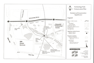 Federation University Historical Collection
Document - Plan, Mathew Gibson, Centre for Environmental Management, Ballarat Technology Park Conservation Plan, 1997, 1997
The Ballarat Technology Park is on the Mount Helen Campus.A4 photocopy of a plan of the Ballarat Technology Park showing features of conservation significance. The plan includes the Canadian Creek, an historic hand-made brick culvert, Canadian Wetland Development, early wooden bridge, old path of the Ballarat-Buninyong Railway line, Greenhill Enterprise Centre and IBM Global Services.ballarat technology park, greenhill enterprise centre, ibm global enterprises, ballarat-buninyong railway line, canadian wetlands, brick railway culvert, canadian creek, riparian woodland, yarra gum, swamp gum, blackwood, remnant vegetation, scent bark, narrow-leaf peppermint, messmate, centre for environmental management, mount helen campus -
Vision Australia
Plan - Text, Allom Lovell and Associates, RVIB Conservation Management plan, 2002
Commissioned by the RVIB, this Conservation Management plan provides an assessment of the cultural significance of the buildings and develop conservation policies around future management of the site.1 CD with 1 Word fileroyal victorian institute for the blind, buildings -
Federation University Historical Collection
Document - Conservation Management Plan, Wendy Jacobs et al, Ballarat Municipal Observatory - Conservation Management Plan
A Conservation Management Plan of the Ballarat Municipal Observatory, produced by Dr David Rowe of Authentic Heritage Services Pty Ltd and Wendy Jacobs, Architect & Heritage Consultant for the City of Ballarat and the Ballaarat Astronomical Society in April 2007.astronomy, ballarat observatory, ballarat municipal observatory, conservation management plan, cmp -
University of Melbourne, Burnley Campus Archives
Plan - Photocopy, Wendy Varcoe, Killamont, 1907? 1980?
Larger plan is probably of original fencing and drains from C.B. Luffman's layout. Killamont is the only known surviving private garden designed by Luffman.(1907).Photocopies of 2 hand drawn maps/plans of the garden at "Killamont." Drawn by Wendy Varcoe. Garden designed by C. B. Luffmann. (Also see B10.0040 Conservation Analysis and other C.B. Luffmann files in Box 75 A .)gardens, killamont, wendy varcoe, charles bogue luffman -
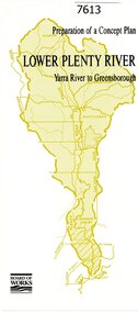 Greensborough Historical Society
Pamphlet, Melbourne & Metropolitan Board of Works, Lower Plenty River: Yarra River to Greensborough: preparation of a concept plan, 1990
This pamphlet outlines a proposed concept plan for the lower Plenty River, Greensborough to Heidelberg. The plan would focus on preserving and enhancing the aesthetic, recreational and conservation potential of the waterway.2 p., illus., tri-fold pamphlet. 2 copiesplenty river, melbourne water corporation, board of works -
 Kew Historical Society Inc
Plan - Subdivision Plan, Old Kew Golf Links Estate - Third Section, 1920-1929
Pru Sanderson, in her groundbreaking ‘City of Kew Urban Conservation Study : Volume 2 - Development History’ (1988), summarised the periods of urban development and subdivisions of land in Kew. The periods that she identified included 1845-1880, 1880-1893, 1893-1921, 1921-1933, 1933-1943, and Post-War Development. These periods were selected as they represented periods of rapid growth or decline in urban development. An obvious starting point for Sanderson’s groupings involved population growth and the associated economic cycles. These cycles also highlighted urban expansion onto land that was predominantly rural, although in other cases it represented the decline and breakup of large estates. A number of the plans in the Kew Historical Society’s collection can also be found in other collections, such as those of the State Library of Victoria and the Boroondara Library Service. A number are however unique to the collection.The Kew Historical Society collection includes almost 100 subdivision plans pertaining to suburbs of the City of Melbourne. Most of these are of Kew, Kew East or Studley Park, although a smaller number are plans of Camberwell, Deepdene, Balwyn and Hawthorn. It is believed that the majority of the plans were gifted to the Society by persons connected with the real estate firm - J. R. Mathers and McMillan, 136 Cotham Road, Kew. The Plans in the collection are rarely in pristine form, being working plans on which the agent would write notes and record lots sold and the prices of these. The subdivision plans are historically significant examples of the growth of urban Melbourne from the beginning of the 20th Century up until the 1980s. A number of the plans are double-sided and often include a photograph on the reverse. A number of the latter are by noted photographers such as J.E. Barnes.When the old Kew Golf Links was subdivided in the mid 1920s, the developers were able to break the sale into sections. The third section included eighty lots. The lots faced Kilby Road, Kodak Avenue, Belford Road, Baker Avenue, Mathers Avenue, and White Avenue. [Kodak Avenue was renamed Page Avenue at a later date].The ‘Kew Conservation Study (1988) notes that ‘On the subdivision plan, Kodak’s involvement is commemorated by the naming of the streets after Company directors, and their decision to not proceed with the construction of the factory is explained as a response to the increase in the value of the land. This explanation may have been Estate Agent’s hyperbole, as the Kodak Company records suggest that the land, with its wide creek gully, was unsuitable and too small for its purposes.subdivision plans - kew, old kew golf links estate - third section -
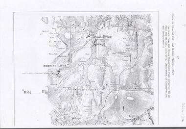 Bendigo Historical Society Inc.
Document - DIAMOND HILL AREA MAP
Map copy, 2 pages, from 'Old Mines Department Plan, Dept of Conservation and Environment File No W91006, 16.6.1972' Map shows Golden Gully area with 'Town and Country Hotel' on north side and further south, with shafts and mine names marked.bendigo, mining, diamond hill -
Port Melbourne Historical & Preservation Society
Booklet, Ministry of Planning & Environment, Urban Conservation Areas, Aug 1986
... Ministry of Planning & Environment ...Booklet outlining the historic and architectural character of a number of areas in Melbourne's inner suburbs including Port Melbourne, and their subsequent designation as Urban Conservation areas. Brown and cream 14 page booklet, cover showing terrace houses. Also Community Planning Bulletintown planning, built environment, parks and gardens, heritage, conservation - urban, conservation - parks and boulevards, ministry for planning and environment, urban conservation areas -
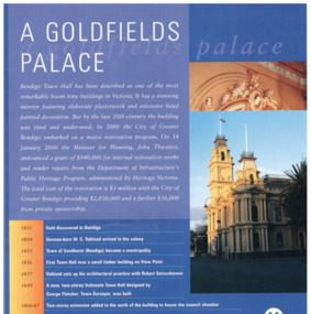 Bendigo Historical Society Inc.
Pamphlet - Bendigo Town Hall Self Tour and conservation timeline brochure, 2003
Parry Collection In 2003, the Bendigo Town Hall was returned to its 19th-century splendour after an extensive restoration and renovation program including plasterworks, murals and gold leaf worked by artists and artisans. The original Bendigo Town Hall was designed in 1859 by Bendigo's town clerk, George Avery Fletcher. A council chamber was added in 1866 and a hall for the trading of grain, known as the Corn Exchange, was added in 1871-72. Although the architecture of the additional buildings adhered to that of the original building, the completed building was unpopular with both the citizens and council of the era. In a series of major works from 1878 to 1902 the Bendigo Town Hall was transformed by the architect William Vahland who was given the task of converting the hall into something worthy of Bendigo's leading position as the "City of Gold".[2] His work included extensive new offices, enlargement of the main hall and council chambers, the introduction of an interior decorative scheme, a clock tower and mansard roof. The exterior facades were also remodelled in the classical style. Vahland commissioned Otto Waschatz, who had just decorated the Royal Palace in Copenhagen, Denmark, to design the hall's interior which featured decorative plaster adorned with 22-carat gold leaf, reflecting the opulence of the "city built on gold". The end result, completed in 1885, was one of Vahland's most significant works and has been considered the finest "boom style" building of its kind in Victoria.Bendigo Town Hall Self Tour and conservation timeline brochure. 1. A yellow paper map with the history of the town hall on one side and a self guide tour and plans on the other side. 2. A glossy 4 page guide to the history of the town hall and timeline.history, bendigo, merle lummis collection, bendigo town hall -
 Bendigo Historical Society Inc.
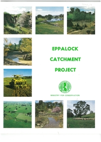
Book - EPPALOCK CATCHMENT PROJECT
43-page soft cover booklet entitled 'Eppalock Catchment Project' Contents include Before 1960, Environment, Extension, Planning, Implementation, Production. Published by the Soil Conservation Authority 1975 First published 1972 Printed by C H Rixon Government PrinterMinistry for Conservationeppalock, eppalock catchment project, ministry for conservation -
 Federation University Historical Collection
Book, Camp Street Precinct Ballarat Conservation Management Plan (Draft), 1999, 10/1999
The conservation management plan was commissioned by the City of Ballarat to assist in the process of planning for the future management and development of the Camp Street precinct, having particular regard for the Camp Street Arts and Education Precinct.White, soft covered, spiral bound book relating to Ballarat's Camp Street Precinct. Contents include: Methodology, buildings and site layout. ballarat, camp street, clare gervasoni, ballarat fine art gallery, art gallery of ballarat, old colonists' hall, former ballarat mining exchange, former state offices, former police court, former police station, former police barracks, old police station, arts academy, archaeology, conservation management plan -
 Mission to Seafarers Victoria
Plan - Architectural Plan, copy, Walter Butler, c. 2013
The copy was part of the conservation plan written by Peter Doig Architecture. Doig Architecture joined Baldasso Cortese in 2019.Large copy in black and white on glossy strong paper of the original bButler plan for the first central mission, Siddeley Street, held at the State Library of Victoria.peter doig, redevelopment, built heritage, walter richmond butler (1864–1949), siddeley street institute -
 Bendigo Historical Society Inc.
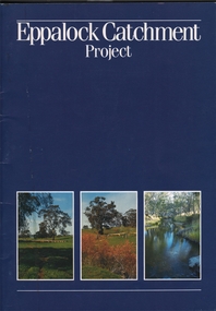
Book - EPPALOCK CATCHMENT PROJECT
27 pages booklet about the Eppalock Catchment Project - A soil conservation success story. Contents: Introduction; Before 1960; Environment; Extension; Planning and works; Implementation; Production; Eppalock-25 years on; What has the Eppalock Catchment Project demonstrated? Also with the book a 4 pages typewritten programme from the Soil Conservation Association of Victoria, Eppalock 25th Celebration, Ecumenical Thanksgiving Service, Sunday 13 October, 1985. at 11.45am - Mia Mia recreation Reserve.civil engineering, water supply, eppalock -
Kew Historical Society Inc
Archive (series) - Subject File, McDonalds (Fast Food Restaurant)
Kew Historical SocietySince its foundation in 1958, members of the Kew Historical Society have been compiling and storing information about subjects relating to the history of Kew and its environs, of which this file is an example. Arranged by Secondary Values (value of records to users)Subject file created by researchers of the Kew Historical Society containing information about the McDonald's fast food franchise in High Street, Kew. The file contains a number of primary and secondary sources including newspaper cuttings, planning objections, correspondence between KHS, the City of Kew, the Administrative Appeals Tribunal, and the Department of Conservation and Natural Resources etc. The file also includes copies of the plans for the proposed restaurant. mcdonalds fast food franchises, mcdonalds restaurant -- kew (vic.), administrative affairs tribunalmcdonalds fast food franchises, mcdonalds restaurant -- kew (vic.), administrative affairs tribunal -
Villa Alba Museum
Document, Andrew Thorn, Villa Alba: Condition Survey and Stabilization of Critical Surfaces, 1997
This report was commissioned by the Villa Alba Preservation Committee following evidence of deterioration on a number of important surfaces at Villa Alba. The report documents changes that have occurred and compares them to the situation reported on in 1986. The report then outlines treatments carried out in 1986 and recently for each of the rooms worked on in 1986.36-page conservation report conducted by Andrew Thorn (Artcare) in 1997 of surfaces in Villa Alba. The report has the following structure: Condition Survey, Treatment Materials and Methods, Detailed Work in Each Room. This copy of the draft report includes detailed plans showing areas requiring stabilization.This report was commissioned by the Villa Alba Preservation Committee following evidence of deterioration on a number of important surfaces at Villa Alba. The report documents changes that have occurred and compares them to the situation reported on in 1986. The report then outlines treatments carried out in 1986 and recently for each of the rooms worked on in 1986. villa alba museum, conservation reports, andrew thorn, artcare, conservation treatments -
Federation University Historical Collection
Booklet, Ballarat School of Mines Botanical Gardens Conservation/Restoration Management Plan
A Conservation/Restoration Management Plan for the Ballarat School of Mines Botanical Gardens. The report includes a planting timeline of the plants included in the gardens from 1850. Historical plans and maps are detailed from 1857 up to the site assessment in 2008.Printed report stapled at top left corner.Lisa Palmer written at top right corner in pencil.smb, school of mines ballarat, ballarat school of mines, botanical gardens, smb botanical gardens, conservation, restoration, ballarat school of mines garden, von mueller garden, ferdinand von mueller, botany, living collections, horticulture, gardens -
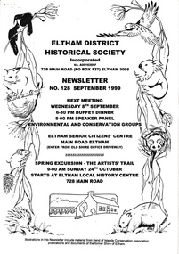 Eltham District Historical Society Inc
Newsletter, Newsletter, No. 128 September 1999
Contents: • Next meeting, Speaker Panel; Environmental and Conservation Groups • September Meeting • Spring Excursion – The Artists’ Trail • Acquisitions • President’s Notes • Nillumbik Planning Scheme – Heritage Planning Controls • Geoffrey Loftus-Hills • Other News Items The Shire of Eltham Historical Society was formed in October 1967. The first newsletter of the Society was issued May 1978 and has been published continuously ever since on a bi-monthly basis. With the cessation of the Shire of Eltham in late 1994, the Society's name was revised to Eltham District Historical Society and this name first appeared with issue No. 103, July 1995. The collection of the Society's newsletters provides a valuable resource on the history of the Society's activities, office bearers and committee members, guest speakers and subjects of historical interest pertinent to the former Shire of Eltham and the Eltham District.A4 photocopied newsletter distributed to membersnewsletter, eltham district historical society, shire of eltham historical society -
Whitehorse Historical Society Inc.
Pamphlet, Kilbarron, 1999
Kilbarron, 1 Laurel Grove, Blackburn, c 1921; A.J. Elmore [builder], by Anne Jones. Vol 1 Conservation Plan, Vol 2 Land Title. Documents with bookmark celebrating the work of A.J. Elmore. Submission for Advanced Diploma in Local and Applied History from the University of New England.elmore, algernon john, elmore houses, laurel grove, blackburn, no 1., kilbarron, anderson, john, branchflower, herbert arthur, mullett, lyndhurst thomas, coates, peter, atkinson, john malcolm